Instituto Politécnico de Tomar – Universidade de Trás-os-Montes e Alto Douro (Departamento de Geologia da UTAD – Departamento de Território, Arqueologia e Património do IPT)
Master Erasmus Mundus em QUATERNARIO E PRÉ-HISTÓRIA
Dissertação final:
Terminal Pleistocene Lithic Technology and Adaptation from
Bulbula River B1s4 Site, Ziway-Shala Basin, Ethiopia
Abebe Mengistu Taffere
Orientadores:
David Pleurdeau (PhD) Clément Ménard
Steven A. Brandt (PhD)
Júri: Marta Arzarello, Carlo Peretto, Jose Martinho Lourenço, Silverio Figueiredo, Gema Chachon, Antony Borel, François Semah, Carlos Lorenzo, Robert Sala
Ano académico 2014/215
Abstract
Archaeological excavation which had been conducted in 2009 and 2010 in the Ziway- Shala Basin, close to the Bulbula River Canyon at B1s4 site, has yielded lithic assemblages and few faunal remains. Two human occupation horizons (PS1 and PS2) were identified which are separated by an occupational hiatus at the very end of the terminal Pleistocene. Analysis of debitage on both unit levels indicates the presence of similar features that lead us to assume that B1s4 lithic industry was oriented towards the production of blades and bladelets. But, this site shows strong technological and industrial variabilities to early Holocene sites which are very close to B1S4. The microliths, which are widely discovered at early Holocene sites-and to a lesser extent sites dated to Pre-Maximum Glacial Maximum-are hard to find at B1s4.Alike Paleoenviromental records in the Ziway-Shala basin and other parts of Ethiopia and Eastern Africa, B1s4 has proved that terminal Pleistocene was characterized by fluctuating weathering conditions that might have forced hunter-gatherers in the region to practice diverse adaptive strategies.
Acknowledgments
First I would like to take this opportunity to thank my supervisor Clément Ménard, Université Toulouse Jean Jaurè, France, for his valuable suggestions, constructive comments, and unreserved guidance and direction for the overall enrichment of this thesis. I am also greatly indebted to my supervisor, Dr. David Pleurdeau, Museum National D'histoire Naturelle de Paris, France, who significantly supporting and facilitating this research since the beginning of this project. I am also sincerely grateful to my co-supervisor Dr. Steven A. Brandt, University of Florida, USA, who was also responsible in supporting this research by providing assistance and alternative views during the analysis of the materials.
I wish to thank also the European Union’s Erasmus Mundus program who providing the funding support for my study and research. I would like also to thank my professors and staff members who work in Prehistoric Art Museum of Mação, Instituto Politecnico de Tomar, Universidade de Tras-os-montes e Alto Douro and Universita' Degli Studi di Ferrara for their advice and support providing to me during my two years of Stay.
I am also very grateful to Late Stone Age Research Project in Ethiopia Directors, Dr. François Bon (Université Toulouse Jean Jaurè, France) and Asameraw Dessie (Authority for Research and Conservation of Cultural Heritage /ARCCH), Ethiopia) for granting me a permit to study their lithic materials from Bulbula B1s4 site. I would like also to thank ARCCH which provided me a laboratory room during the analysis of the lithic materials. My thanks also go to Elizabeth Peterson (University of Simon Fraser, Canada) for her support to analyze the scrapers from B1s4 and also for Dr. Joséphine Lesur (Museum National D'histoire Naturelle de Paris, France) who provided the data of faunal remains. Last, not least, I am deeply indebted to my friend, Aldo Malagó for his unreserved assistance and advice that he did to me for the last two years.
Table of Contents
Chapter One--- 1
Introduction and Research Objectives --- 1
1.1.Background--- --- 1
1.2.Research Objective --- 2
1.3.The significance of the study --- 3
1.4.Statement of the Problem --- 3
1.5.Development of the Research Interest and the selection of the study site--- 4
1.6.Research Methods--- 5 1.6.1.! Data Analysis--- 5 1.6.2.! Debitage Analysis--- 7 1.6.3.! Core Analysis--- 8 1.6.4.! Tool Analysis--- 8 1.6.5.! Exploratory analysis--- 9
1.6.6.! Use Wear Analysis--- 9
1.7. Definitions Retained for this Study--- 10
1.7.1.! Artifact Typology--- 10
1.7.2.! Completeness --- 10
1.7.3.! Length, Width, and Thickness --- 10
1.7.4.! Dorsal Scar Pattern and Scar Counts--- 11
1.7.5.! Presence or Absence of Cortex --- 11
Chapter two--- 12
Cultural and Environmental Background--- 12
2.1.Contextual Data--- 12
2.1.1.! Features of the Ziway-Shala basin, Main Ethiopian Rift--- 12
2.1.1.1.Geology and Geomorphology of Bulbula River--- 15
2.6.LSA Raw Material Exploitation and Socio-Territorial Organization Pattern--- 43
2.7.Characteristic Feature of Blades and Bladelets and their Production Techniques--- 45
Chapter Three--- 48
Literature Review--- 48
3.1. Previous Research on Late Pleistocene LSA--- 48
3.1.1. Late Pleistocene LSA sites in East Africa--- 48
3.1.2. Previous Research on Late Pleistocene LSA sites in Ethiopia--- 48
3.2. Brief Review Late Pleistocene Paleoenvironment in East and the Horn of Africa--- 56
3.2.1. Paleoenvironment of East African Late Upper Pleistocene--- 56
3.2.2. Paleoenvironment of Ethiopian Late Upper Pleistocene --- 58
3.2.2.1. Lower Omo Basin--- 59
3.2.2.2. Central and northern Afar--- 59
3.2.2.3. Besaka--- 60
3.2.2.4. K’one Crater Complex/Garibaldi Caldera Complex--- 61
3.2.2.5. Aladi Spring--- 62
3.2.2.6. Paleoenvironment of the Ziway-Shala Basin during the Terminal Pleistocene--- --- 62
Chapter Four--- --- 67
Lithic Analysis--- --- 67
4.1. General Presentation--- 67
4.2.Faunal Remains--- --- 67
4.3. Presentation of Lithic Assemblage--- 69
4.3.1. Raw Material Acquisition--- 69
4.3.2. Raw material Condition--- 70
4.3.3. Dorsal Scar Pattern and Number of Flake Scars--- 71
4.3.4. Striking Platforms--- 74
4.3.5. Debitage Assemblage Analysis --- 75
4.3.5.1. Cores--- 77
4.3.5.3. Blades and Blade fragments--- --- 82
4.3.5.4. Bladelets and bladelet fragments--- --- 84
4.3.5.5. Chips and shattered pieces--- --- 85
4.3.6. Tools--- --- 86
4.3.6.1. Scrapers (N=14) --- --- 88
4.3.6.2. Use Wear Study of Scrapers--- --- 90
4.3.6.3. Burins--- --- 93
4.3.6.4. Other shaped tools--- --- 93
4.3.6.5. Utilized tools--- --- 97
Chapter Five--- --- 99
Discussion and Conclusion--- --- 99
5.1. Lithic reduction sequence analysis--- --- 99
5.1.1. Raw material procurement and site function --- --- 99
5.1.2. Reduction Sequence--- --- 102
5.2. Cultural affinities and chronological place of B1s4 within local and regional LSA framework--- --- 103
5.2.1. Cultural tradition and chronological sequence--- --- 103
5.2.2. Environmental and cultural comparisons --- --- 105
5.3. Conclusion--- --- 110
Appendix--- --- 112
List of Figures
Figure 1: location of study area (B1s4) --- -- --- 13" Figure 2: satellite image (Landsat) of the Ziway-Shala basin--- --- 14" Figure 3: simplified geologic map of the study area (Ziway-Shala basin)--- --- 16" Figure 4: Fluvio-lacustrine sediment, east of Lake Shala --- --- 18 Figure 5: Pumice deposit, northeast of Lake Ziway--- --- 19 Figure 6: synthesis of the main geomorphological features in Ziway-Shala--- --- 21" Figure 7: Main paleoanthopological sites and geographic features--- --- 23 Figure 8: areas investigated by the LSA Sequence in Ethiopia --- --- 25" Figure 9: schematic cross-section along Bulbula River (Ziway-Shala Basin)---- --- 28 Figure 10: Geological log of the sedimentary formations in Bulbula--- --- 30 Figure 11: Radiocarbon dates of archaeological sites in Bulbula--- --- 31" Figure 12: view of B1s4 at the end of excavation in 2010--- --- 33 Figure 13: Location major LSA sites in Eastern Africa--- --- 37" Figure 14: Artifacts covered in patina--- --- 71 Figure 15: graph shows classes of main debitage from B1s4--- --- 77 Figure 16: the various core types--- --- 79" Figure 17: selected blades blanks --- --- 83 Figure 18: Long and thing bladelets blanks--- --- 84 Figure 19: scrapers drawing illustration--- --- --- 89" Figure 20: Bulbula scraper showing scraping wear --- --- 91" Figure 21: Experimental tool used in a cutting motion--- --- --- 92 Figure 22: the graphs represent the frequency of different tool forms--- --- 94 Figure 23: Straight backed pieces from B1s4, bulbula--- --- 95
Lists of Table
Table 1: radiocarbon dates of archaeological sites in Bulbula
and sites outside the Ziway-Shala Basin. Dates for comparative--- --- 32
Table 2: total number of identified and unidentified faunal remains of B1s4)--- --- 68
Table 3: the identified dorsal scar patterns --- --- 72
Table 4: inventory butt types from B1s4--- --- 74
Table 5: descriptive analysis of different debitage classes --- 76" Table 6: inventory of platform types and core blank types--- --- 78
Table 7: inventory of Flakes as whole flakes and fragments--- --- 81
Table 8: inventory of various tool classes from B1S4--- --- 87
Table 9: different classes of scraper --- --- 88
Table 10: use wear hardness scale revised --- --- 90
Table 10: Descriptive statistics of burin--- --- 93
Table 12: Descriptive statistics of microliths, notches and backed pieces--- 96
Chapter One
Introduction and Research Objectives
1.1.! Background
The archaeological survey and excavation which had been conducted by Late Stone Age Research Project in Ethiopia from 2007 -2010 had revealed human occupation horizons at Bulbula which were dated to early Holocene, Terminal and early Pleistocene period (Bon et al., 2013). The study site, B1s4, from Bulbula 1 locality is part of this project and it was first discovered in 2008. Charcoal sample from the lower paleosol (PS1) level of B1s4 were taken for radiocarbon dating and dated to 12,040 ± 50 (14,045-13,755 cal BP) using AMS dating. Therefore, the earliest occupation at B1s4 site is belongs to the Late Stone Age, particularly for the Terminal Pleistocene period (Ménard et al., 2014) which was characterized by fluctuating climate conditions such as an increasing temperature and moisture, but it was mainly interrupted by an abrupt return to the arid condition and probably Younger Dryas climatic reversal (Kiage and Liu, 2006: 644). This fluctuating climatic condition during the terminal Pleistocene increasingly modified the cultural and subsistence strategies of the hunter-gatherers. Chronologically, the terminal phase of the last glaciation in East Africa had prevailed after 12,500 BP and had continued into the onset of the Holocene (Kiage and Liu, 2006: 644).
Moreover, during this period the cultural and environmental interaction and contact of hunter-gathers is a focus of many archaeological researchers in the field who are interested to understand human adaption. During this period, hunter-gathers may have been forced to design
Therefore, my thesis project focused on the analysis Terminal Pleistocene lithic materials from B1s4 site which had been excavated and collected by the project of Late Stone Age Sequence in Ethiopia directed by François Bon (Université de Toulouse, France) and Asamerew Dessie (ARCCH, Ethiopia).
1.2.! Research Objective
The main objective of this research was to understand technological adaptation of B1s4 Bulbula hunter-gatherers to the major resources and environmental changes that took place during the Terminal Pleistocene. The specific objectives of this research are the following:
1.! To understand characteristic features LSA lithic technology at B1s4 and how Terminal Pleistocene hunter-gatherers at B1s4 organized and used the surrounding landscape during this period;
2.! To investigate how the cores were exploited during the manufacture of flakes;
3.! To understand the subsistence strategy of hunter-gatherers of B1s4 based on evidence found on lithic and faunal remains;
4.! To understand technological and typological traditions as well as behavioral and social changes that prevalent during the end of the Pleistocene and the onset of the Holocene at Bulbula (B1s4);
5.! To compare and contrast the typological and technological features of Bulbula B1s4 lithic assemblage from local and regional site such as B1S4, DW2S1, DW2S2 at Bulbula and FEJx2 at Lake Besaka and others;
1.3.! The significance of the study
The terminal Pleistocene, which is characterized by fluctuating and turbulent climatic conditions, has been the concern of archaeologists who have been working on this period. In Ethiopia, this period spans from c. 18,000-12,000 BP and culturally has been understood by few stone artifacts uncovered from Lake Besaka (Brandt, 1982) and Bulbula B1s1 (Ménard et al., 2014; Habte, 2014). Yet, there is a lack of data to understand the technological aspect, subsistence strategy and adaptation behavioral aspect of hunter-gatherers who were living during this terminal Pleistocene period. So, this thesis would generate additional data which are useful for understanding paleoenvironment, cultural behavior and economic subsistence of hunter-gathers of the terminal Pleistocene period.
1.4.! Statement of the Problem
Despite several attempts had been made to establish the chronology and techno-typology pattern of LSA industry of the Horn of Africa, yet this period remains poorly understood. There is no general consensus about the definition and the chronological boundaries among the researchers working in the region. It is ‘catch-all concept’ which depends on different kind of contexts and industries dated between MIS3 and Late Holocene (Ménard et al., 2014). Researchers such as Brandt (1982) characterized LSA dominantly by the existence of backed microlithic tools and blade-core technology. Others said that LSA culture is apparent by the production of blade and miniaturization (Ménard et al, 201. All agree that archaeological reality is much more complex, and widely accepted that the existing archaeological data is not sufficient enough for understanding hunter-gatherers technological behavior in the region because the
Despite several research projects has been conducted in order to establish the chronology and typology of LSA in the Horn of Africa, the available data did not produce enough information and yet this period remains poorly understood. Hence, in order to generate more data useful for understanding the chronology and the nature of technological and environmental changes in the LSA period in general and the Terminal Pleistocene in particular, more data are needed sites like Bulbula. Therefore, the data from Bulbula (B1s4) has the potential to yield important information to understand Terminal Pleistocene hunter/gatherers cultural development in the Ziway-Shala basin, which is located in the Main Ethiopian Rift. My research project therefore focused to understand the adaptive strategies of the Terminal Pleistocene hunter-gathers in Bulbula (B1s4) through close examination of the technological innovation, land use and mobility pattern, and subsistence strategies.
1.5.!
Development of the Research Interest and the selection of the study site
My research interest on the study of lithics developed in 2013 when I have started to work on analysis of lithic materials collected from Mezber by Eastern Tigray archaeological Project (ETAP) near to Adigrat town. The reason for selecting B1s4 for study is related to the importance of the site for yielding information about the technological and behavioral adaptations of the hunter-gathers of the Terminal Pleistocene period as the areas is preserved important water bodies of the Ziway-Shala basin that may provide resources during the bottle neck period faced the Last Glacial Maximum hunter-gathers. In addition, the B1s4 has preserved important sedimentary formations of two paleosols in which one of it was securely dated and could provide data to answer hunter-gather adaptive strategies of the new environment they encounter during the Terminal Pleistocene and also it offers me an opportunity to compare toother post-LGM site of Bulbula like B1S1 studied by Habtie (2013)and DW2S1 and DW2S2 (Ménard et al. (2014).
1.6.! Research Methods
1.6.1.!Data Analysis
During classifying and analyzing lithic artifacts, researchers employ different approaches and often determine the methodologies based on the type of question they would like to address. According to Vanpool and Leonard (2011), both qualitative and quantitative methods are important for the analysis of lithic assemblage. The qualitative and theoretical perspective tells us which observations are important to make and how explanations are constructed. On the other hand, quantitative methods and statistical techniques play an important role in archaeological analysis because archaeologists rely on heavily on fragmentary archaeological samples that time and the vagaries of environment (including human activities) allowed to be preserved. These quantitative methods and statistics were employed for data analysis which were collected by systematic observation and analysis of the lithic assemblages. Bearing this in mind, the lithics assemblages derived from B1s4 were analyzed using both qualitative and quantitative methodological approach.
Qualitative data analysis would be organized using the lithic assemblages uncovered during excavation as well as referring the draft notes taken during the field work. In order to develop standard classification system, first levelled the artifacts on the table at the laboratory room available by Authority for Research and Conservation of Cultural Heritage (ARCCH). This would be useful for me to be apparent for the different form of tools variability and for the
of dealing with the observed variability, yet would be easy to understand and relatively fast to record.
The analysis of lithics begins with the identification and classification of lithic assemblages. Classification plays a great role for the summarization of data for descriptive purpose. It plays also a role as a heuristic device (Andrefsky, 2005). According to Whittaker (1994:270), there are four factors that govern the shapes of the lithic artifacts. These factors include 1) the raw material of which the tools are manufactured, 2) the technology employed during the production of the artifacts, 3) the function or purpose of the artifacts, and 4) the style of characteristic mode of tool form current among the people making the object. During the analysis of B1s4 lithic assemblages, the raw material choice and the technological employed were systematically examined and used to develop a classification scheme for my data analysis (based on both qualitative and quantitative method) as well as to achieve my research goals. The prehistoric hunter-gathers from B1s4 were totally produced their lithic artifacts from obsidian which are available near to the site. In addition, the techniques applied and the technologies practiced at B1s4 were traced by analyzing individual debitages, cores and tools. The stage of manufacture and the manufacturing techniques exhibited on each artifact provide evidences to understand the technology employed during the production of artifacts. So, taking in account this, individual lithic artifacts from B1s4 would be carefully classified and examined in order to determine an artifact was as cores, tools and debitages in one hand and to reconstruct the technical and technological procedures of a given assemblages on the other hand. For debitage analysis, decortications of debitage analysis, tool debitage analysis, and hierarchical analysis were employed. To understand core reduction sequence, both core and flake assemblages were analyzed.
1.6.2.!Debitage Analysis
Most prehistorians who study lithics have given much attention for cores and tools relatively compared to flakes and debris, collectively they are called debitage, during the classification and the analysis of lithic assemblages (Fish, 1981: 374). Debitage are flaked products removed by either pressure or percussion techniques. They tell the whole process which includes wide variety of activities and varies stages of process of the raw material from the original to the finished stages (Inizan et al 1999; Fish, 1981: 374). The analysis of debitage can be differed from one to another depending on the purpose of lithic studies (Gang, 1997). But, whatever such variations exists among researchers, the methods of debitage analysis can be largely divided in to two classes: individual flake analysis and flake aggregate analysis (Anderfsky, 2005; Ahler 1989:86 cited in Gang, 1997: 89). The individual flake analysis comprises decortication or core reduction debitage analysis, tool debitage analysis and hierarchical analysis (Gang 1989:89).
During the analysis of B1s4 lithic artifacts, I used individual methods of debitage analysis particularly for whole flakes, blades, bladelets, cores and tools. On the other hand, angular wastes, broken flakes, chips and shatters were analyzed in aggregate or mass analysis system. According to Gang (1989: 106), during mass or aggregate analysis, individual artifacts are not investigated, instead this debitage analysis method favors counting and weighting of the total artifacts in a given artifact sample. For individual debitage analysis, the basic and common debitage attributes such as the size and shape of every whole flakes (maximum length, width and thickness), artifact type, platform type, cross-section, the presence or absence of cortex, nature of
computer. The same attribute analysis table is used for tools and cores. This attribute table is adopted and modified from Brandt (1982; 2012).
1.6.3.!Core Analysis
Researchers employ different methodological approach for core analysis. Morphological
description, technological analysis or graphical representations of technological attributes are some of the methodological approaches often used by researchers. These methodological approaches of core analysis provide information about temporal relationships between flake removals. It also offers spatial information and gives information useful to know different stages of reduction sequence and movement of abandonment of reduction process.
Specific core industries such as blade and bladelet constitute a small part of the lithic assemblage of B1s4 and in order to understand reduction sequence of the assemblage, all of these cores were analyzed from morphological and technological point of view. Experimental archaeology has provided useful data for the understanding of reduction sequence of cores. In their early stage, cores are mostly characterized by large and heavy features and exhibit few scars on the major removal face and simple scar pattern. When it reaches at middle stage, both core size and removal surface area on cores reduced. At this stage, the negative features of the core manifests complex features both in terms of scar count and pattern which resulted from the previous scar pattern. In final and latter stage, reduction of core often characterized by amorphous shape and very complex scar pattern and high scar counts (Baumler 1987:27; Munday, 1976:120 cited in Gang, 1989).
1.6.4.!Tool Analysis
According to Anderfsky (2005: 76), tools “are considered to be all those chipped stone objective pieces that have been modified by intentionally altering their form and those detached
pieces that show signs of modification as a result of use”. Tools can be identified either by the task for which it was produced or the type of choice made by the makers among several equally valid and feasible options. The task of every tool is measured by its functional attributes, but the type of choice of the material is related to stylistic attributes. For this thesis, the lithic assemblage from B1s4 is investigated by dividing into shaped and unshaped tools. Shaped tools comprise scrapers, retouched flakes, backed pieces, while unshaped tools include irregular modified pieces and lithics with utilized edge.
1.6.5.!Exploratory analysis
Further analytical tools would be employed and the data on the attribute table were represented visually using for example frequency distributions like histogram, bar chart, pie chart etc. Then, the data summarized in the graphical representation were again further described by using numerical form of descriptive statistics which can be based on a single variable. This numerical characterization of the data allows a more formal means of both describing a distribution and comparing two or more distribution. These numerical descriptions of distribution are termed either statistics or parameters depending on whether they describe a population or a sample. Statistics are descriptions of the characteristics of a statistical sample, whereas parameters refer to the characteristics of statistical population Vanpool and Leonard (2011).
1.6.6.!Use Wear Analysis
Use wear analysis is the study of the function of tools based on the complex analysis of all traces of use, including macro-deformations, micro-linear traces and polishes (Peterson, 2015). This study can be investigated by using both low-power or high-power microscope
14 shaped obsidian tools classified as different types of scrapers from B1s4. According to here report, the method used within the analysis is the standard low-power use wear method developed by Dr. George Odell (1977). Before evaluation, each stone was washed carefully in water and then lightly bathed in 50% acetone to clear away any hand grease that could be confused as polish under microscopic inspection. The tools were then each evaluated under a stereomicroscope of 6 to 80X magnification, tracking the location, type, and frequency of the different wear attributes.
1.7.! Definitions Retained for this Study
1.7.1.!Artifact Typology
Artifact type is a subjective, macro-level assessment based on presence or absence of specific features on each artifact (e.g. lateral retouch, butt morphology, and overall artifact length, width, and thickness).
1.7.2.!Completeness
Completeness is determined based on whether or not the artifact was broken during use-related activates or during production or post-depositional processes. When an artifact had a bulb of percussion or unbroken proximal end, intact lateral edges, and intact distal tip or bit, it was coded as complete. Other codes, for example, like proximal flake and distal flake fragment were used if the artifact had an intact proximal end and lateral edges and distal end and lateral edge respectively.
1.7.3.!Length, Width, and Thickness
Length, Width, and Thickness was recorded in millimeters (mm) and measured maximum limits of each artifact. Each artifact was held perpendicular then parallel during the
measuring process. Measurements were recorded with one electronic digital caliper that measures to the hundredth of a millimeter (0.00 mm).
1.7.4.!Presence or Absence of Cortex
Cortex was measured only viewing the dorsal surface of the artifact and was recorded either the presence or absence of cortex.
1.7.5.!Dorsal Scar Pattern and Scar Counts
Dorsal scar patterns can indicate particular reduction sequences and illuminate standards in production or reduction of stone tools. For example artifacts may have parallel or convergent dorsal arrises indicating unidirectional core flaking. On the other hand scar counts are refer to the number of flake scars evident on the on the dorsal face of the flake.
Chapter two
Cultural and Environmental Background
2.1.Contextual Data
2.1.1.!Features of the Ziway-Shala basin, Main Ethiopian Rift
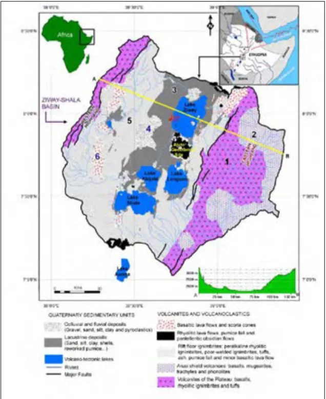
The Ziway-Shala basin is located in the Main Ethiopian Rift (hereafter called MER), which is part of the northern extension of East African Rift System. Its northern limit extends to the Red Sea and Gulf of Aden rift system (Gasse and Street, 1978: 280). The study area, B1s4, is found in the Ziway-Shal Basin and it is located at 07°49.125’ N and 038°41.909’ E close to the edge of Bulbula canyon and to the north of Bulbula 1 locality (figure 1 and figure 2) (Bon etal., 2013). It is part of the Bulbula Plain which is situated between Lake Ziway and Lake Abijata and extends 28 km in length and 10 km in width. This wider plain area varies in elevation ranging between 1640 and 1700 m a.s.l. In the eastern and western part, the Bulbula plain is bounded by Alutu volcano and, the Waso and Macho hills respectively (Di Paola, 1972).
Figure 1: Photo showing location of study area (B1s4) in the Bulbula plain with some addation (Bulbula 1 locality). Courtesy of F. Bon. and C. Ménard.
The Bulbula River connects the two most northern lakes (Lake Ziway and Lake Abijata).
Lake Abijata receives water from in its northern end from the Bulbula River that discharges from Lake Ziway. The Bulbula Rivers flows in deep gorge which is flanked by a cliff measures about 30-35 m in height. Bulbula is part of the Ziway-Shala basin which is located 7-8°30’N latitude and 38°30’E longitude with an elevation ranging from 1558 to 1636 m a.s.l. near the highest part of its floor. Approximately it is 150-210 km away south of Addis Ababa, the Ethiopian capital (Gasse and Street, 1978; Le Turdu et al., 1999: 136; Benvenuti et al., 2002: 247).
Figure 2: satellite image (Landsat) of the Ziway-Shala basin showing the location of main LSA sites (windmills) and sampled obsidian sources (blue dots) (after Ménard et al., 2014: 57).
As it has presented in figure 2, the Ziway-Shala basin comprises rift-bounded chains of four different lakes (Ziway, Langano, Abijata and Shala) which were different times connected
and formed a single lake during the late Pleistocene and Holocene (Benvenuti et al. 2002: 247;
Street, 1979; Chernet 1982). These lakes measure an area of about 14,640 km2 and they are
hydrologically closed, but surface water network connects the three northernmost lake of Ziway, Langano and Abijata (Le Turdu et al., 1999: 138).
The Ziway-Shala basin in the MER is bounded by steep border fault escarpment of 70-80 km apart. These escarpment border the Ethiopian plateau to the west and the southeastern part to the east. It is surrounded by trachytic shield volcanoes of Pliocene shield age that includes Mount Chilalo (4006 m), Mount Badda (4170 m) and Mount Kubasa (3760 m) in which these mountains overlook the Ziway-Shala lake basin system from the east. The Ziway-Shala basin has preserved the relics of several dormant silicic caldera volcanoes of Mount Bora (2293 m), the Alutu Caldera (2328 m), the O’a Caldera (1960 m), and the Corbetti Caldera (2320 m) which rises above the rift floor (Le Turdu et al., 1999).
2.1.1.1.! Geology and Geomorphology of Bulbula River
The MER divides the 1,000-km-wide uplifted Ethiopian volcanic province symmetrically into the northwest and southeast plateaus. The whole area of MER divided geographically into northern, central and southern sectors (WoldeGabriel, 1990; 1991) which is bordered by the Ethiopian Plateau to the west and the Somalian Plateau to the east (Benvenuti et al., 2002: 248). Distribution of volcanic rocks along the MER boundary faults shows a discontinuous sequence ranging in age from the Oligocene to the Quaternary (WoldeGabriel, 1990; 1991). Huge volcanic eruption especially in the southern and central MER has started in the Late Eocene-Early Oligocene by a basaltic eruption, associated with an early stage of rifting characterized by
full symmetrical grabens and rift-in-rift structures (WoldeGabriel et al., 1990; Le Turdu et al., 1999; Benvenuti et al., 2002).
" Figure 3: simplified geologic map of the study area (Ziway-Shala basin) (after Rango, 2009: 35).
The Ziway-Shala basin in the central sector of the MER was formed by the erupted voluminous flow of rhyolitic ignimbrites and collapsed calderas during early Pliocene tectonic event. This central sector of the MER and its shoulders are made of volcanites and pyroclastic rocks, whereas large areas of the rift floor are covered by volcano-lacustrine and fluvio-lacustrine deposits (WoldeGabriel et al., 1990). Compared to the previous periods, the Late Pleistocene–Holocene time interval appears to be characterized by minor tectonic deformation. During these periods, Wonji Fault Belt (WFB), which formed part of the central sector of MER and eastern marginal graben of the Ziway-Shala basin, and the Silti Debre Zeit Fault Zone (SDZFZ) were the two main areas in the sector of MER dominantly affected by tectonic and volcanic events (Benvenuti et al., 2002). Volcanic activities continue from the Middle Pleistocene to the present in WFB and are marked by the development of fluvio-lacustrine basins. Successive Fluvio-lacustrine basins have been also formed in the Pleistocene-Holocene in an extensive area of the MER floor (Le Turdu et al., 1999; Benvenuti et al., 2002). This was also a time when joint history of sedimentation in the Ziway, Langano, Abijata and Shala lake basins have started in the central MER (Le Turdu et al., 1999).
Figure 5: Pumice deposit, northeast of Lake Ziway (after Rango, 2009: 36)
Lacustrine sediments were formed by non-volcanic activities in portions of the rift. This
lacustrine formation in the portions of the rift valley covered a large area of about 4000km2 and
whose thickness is sometimes considered range from about 40 m in Bulbula River and 50 m in Boru and Maky River up to more than 100 m between Modjo and Koka. These lacustrrine sediments were formed when the big lakes were formed when lakes were filled with water drying up in the area where in the past occupied the floor of the rift valley. Lakes Ziway,
The Late Pleistocene-Holocene deposits of the Ziway-Shala basin have revealed three lithostratigraphic units. The first two, the alluvial and fluvio-lacustrine deposits, formed the lithostratigraphic unit of Meki Formation. Evidence of this formation is recorded on the fluctuation marks identifying in the Meki River base-level (Benvenuti et al., 2002). The other lithostratigraphic unit, which is called Bulbula Formation, was recorded in the Ziway-Shala Basin. Lacustrine diatomaceous marls and calcareous sands formed this lithostratigraphic unit. This formation is dominated by a thick (about 30 m) volcaniclastic Latest Pleistocene unit which preserves erosive surfaces and paleosols used as reference for the transition from Upper Pleistocene to Holocene deposits (Gasse and Street, 1978). The last stratigraphic unit is called the Ajewa Formation which is comprised the eastern shore of Lake Shala. This unit is composed of Late Pleistocene and Holocene deep to shallow lucustrine, shoreface, alluvial and colluvial deposits (Benvenuti et al., 2002).
With regards to geomorphology, striking geomorphological evidences of lake fluctuations and soil formation process have been identified in the Ziway-Shala basins in a form lacustrine recessional still stands, such as terraces and stranded plaeo-shorelines (figure 6). Evidences of lucustrine terraces (V-I from higher to lower) are recognized around Lake Ziway (Benvenuti et al., 2002). Relict shorelines were also identified and they are mainly developed in the southern basin of the MER. Evidences of terraces has continued to develop during the early phases of the Holocene and a single lake had existed during the development of terrace IV dated between 9600 and 9400 BP, with a subsequent flooding at about 5400-5100 BP (Benvenuti et al., 2002).
Figure 6: synthesis of the main geomorphological features related to Late Quaternary lake fluctuations (after Benvenuti et al., 2002:251).
Morphological evidence of lake-level lowering and complete desiccation was recorded in the Ziway-Shala basin. This desiccation is represented by N-S trending depression, 2 km wide and 15 km long, about 2 m deeper than the average lake Ziway bottom, interpreted as a
2.1.1.2.! Climate and Vegetation of the Ziway-Shala Basin
The Ziway-Shala basin modern climatic data has shown a considerable climatic variation within a short distant difference. Mainly, it is marked by alternating wet and dry seasons following the annual movement of the Intertropical Convergence Zone (ITCZ) which separates the air streams of the northeast and southeast monsoons. In the region, the average annual rainfall ranges from 600 mm at the vicinity of lake Ziway to 1200 mm in the high margins (3000 m contour) of the MER. The rainy season (Kiremt) of the study area is in the summer (from June to September), and get about 50-70 % mean annual total rainfall (Degefu, 1987). From October to February, hot and dry weather (Bega) is predominant. This is the season when the ITCZ lies in the southern Ethiopia. At the Ziway area for Example, the average monthly minimum temperature ranges from 9 °C in December to 6 °C in July. On the other hand, the average maximum temperature ranges only from 25 °C in February and July to 29 °C in May (Wendorf and Schild, 1974: 110). In general, in the Ziway-Shala basin, the mean annual temperature is less than 15 ºC in the highlands and more than 20 ºC in the lowlands. Evaporation ranges from more than 2500 mm on the rift floor to less than 1000 mm in the highlands (Le Turdu et al., 1999: 138).
The modern vegetation cover of the Ziway-Shala Basin ranges from open woodland to bushed grassland on the rift floor. Bushed grasslands is identified on the rift shoulders, and then remnants of dry, montane forest and, from 3200 to 3500 m, ericaceous scrub and Afroalpine moorland (Le Turdu et al 1999: 138).
2.2.!
Archaeological and Historical Background Bulbula
The MER, as part of the East African Rift System, contains important paeoanthropological sites where important fossils and cultural remains of hominids have been
uncovered. It comprises well know paleoanthroplogical and archaeological sites such as Konso-Gardula, Gademotta, Gedeb, Melka Kunture and Kesem-Kebena (WoldeGabriel et al., 2000).
Figure 7: Main paleoanthopological sites and geographic features in the northern part of the East African Rift System. (after WoldeGabriel et al., 2000: 84).
Lakes in the 1970s. During the survey, an exposed section near the Bulbula River was revealed that an occupation horizon embedded within a paleosol dated on charcoal to ca. 27,057 ±1,540 BP (Gasse and Street, 1978; Gasse et al., 1980) in which this radiometric data has been considered as the earliest known LSA record in Ethiopia. In addition to the occupation horizons, it was also reported that the site has been littered with obsidian blade industry including non-geometric microliths, scrapers and blades as well as faunal remains which were collected on the surface (Brandt, 1986). Despite its archaeological potential of LSA sequence, no one has conducted a research on the area until the Late Stone Sequence in Ethiopia project took the initiative and started its survey in 2007. This primary survey encompasses different environmental and topographic features including hill tops and paleoshorelines. Among the surveyed areas, the Bulbula river valley attracted the attention of the survey team. This river cuts the sedimentary deposits of the Upper Pleistocene and Holocene formation sediments in which finally the surveyed team recognized two archaeological localities: Bulbula 1 (B1S1,B1S3 and B1s4) and Deka Wede (DW1, DW2S1 and DW2S2) (figure 2) (Ménard et al., 2014).
Figure 8: detailed views of the main areas investigated by the LSA Sequence in Ethiopia project (A. Bulbula, B. Deka Wede), images taken from Google Earth (after Ménard et al., 2014: 58).
2.3.!
Stratigraphy of the Bulbula River
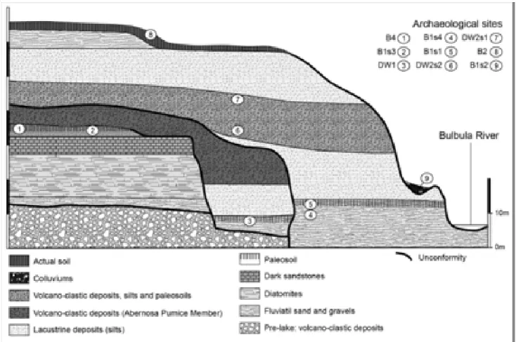
The sedimentary exposures bordering the Bulbula River provided evidence of two pre-Holocene highstands of the lakes in the Ziway-Shala basin, provisionally named as Bulbula I and Bulbula II. The Cultural stratigraphic record of the Ziway-Shala Lake basin had been dated to Late Pleistocene and Holocene based on the sample taken on a reference section designates as 0738-B20. For this stratgiraphic investigation, the most informative section comes from the quite steeply sloping inner walls of the Shala lake and along the Bulbula River (Gasse and Street, 1978; Grove et al., 1975). In Bulbula, the Late Pleistocene and Holocene section is well identified and exposed about 400 m east of Bulbula River in a large gully descending from Mt. Alutu. Two Pre-Holocene highstands of the lakes, provisionally names Bulbula I and Bulbula II, were identified from sedimentary exposures bordering the Bulbula River (Gasse and Street, 1978).
Bulbula I sedimentary deposit was recorded in limited areas and they were found overlying on a fluvial cobble-gravel containing large blocks of tuff and obsidian derived from Mt. Alutu. In Bulbula I, lacustrine sequence begins with thin silt in which a diatomaceous clast provides the only clue to the presence even older lake beds in the area. The basalt silt was overlain by ripple-marked sand containing floated pumice pebbles and very planorbid shells. The upper most and the latest sedimentary deposit are made compact sandy silt which had a thickness from 2.4-4.35 m. This upper most layer of Bulbula I lake bed was unconformobly overlain by fluvial sand pebble-gravel. The upper 20 cm of this sedimentary deposit was made up of a very weakly developed paleosol which preserves abundant worked obsidian artifacts, which probably appeared to be the age of LSA, weathered bone refuses and charcoal. The Charcoal sample has been dated at 27,050 ± 1540 BP (SUA-588) (Gasse and Street, 1978).
Figure 9: schematic cross-section along Bulbula River (Ziway-Shala Basin) showing major stratigraphic units. Key: 1) Holocene Lake deposits and surficial colluviums; 2) uppermost Pleistocene pumice deposits; 3) upper Pleistocene lake deposits; 4) upper Pleistocene fluvial
gravels; 5) hypothetical correlation; 6-9) 14C dates; 6) non-lacustrine sediments (F.A street, new
date); 7-9) lacustrine sediments; 7) F.A street, new date; 8) Geze (1975), approximate location; 9) Laury and Albritton (1975), approximate location. All section numbers are preceded area code 0738 (after Gasse and Street, 1978: 289).
Bulbula II lake beds began with lacustrine mud formation (marl) which was directly resting on the soil. Over the thin marl, ripple-marked or plane-bedded fine sand and silt formed the deposit. This formation is overlain by compact marl which is laminated from 1.5 to 2.0 m and undoubtedly records the lacustral maximum. The upper surface of the marl part were getting smaller slightly before the deposition of the overlying pebbly sands containing occasional corbicula shell, which marks a return to shallower conditions. The top part of this pebbly sand sequence is overlying by thin silt bed represent by a brief episode of non-lacustrine pumice laid down during the succeeding arid phase. Finally, the upper most deposits of Bulbula II lake beds are overlain by 7.45 m non-lacustrine pumices which were formed during the succeeding arid phases (Gasse and Street, 1978).
To know the numerical age of the Bulbula I and II deposits Late Pleistocene, an absolute
dating system (14C) was employed. The charcoal sample (SUA-494) was taken from a paleosol at
the top of the pumice bed and dated to 11,870 ±300 bp (Gasse and Street, 1978). The highest lake deposit was associated with Bulbula II phase at a smaller tributary gully of Bulbula River (0738-B17). The relicts of outcrop measures about 1,641 m. They consist of pumice beach gravel interbedded with waterlaid ash, and overlain by Alutu pumice and then Holocene lake beds.
Shells from the base of the Holocene sediments were dated at 9,360 ± 210 BP on the samples which were taken from the nearby sites (Gasse and Street, 1978).
The Holocene deposits are marked by depositional evidences formed by transgression and regression of the lakes. The presence of initial lake transgression is represented by the thin marl identified in the site. The transgression did not continue and it was replaced by a brief regression that brought in renewal deposition of pumice gravel containing occasional implements. During early Holocene, the level of the lake was increased and deposited the second marl with occasional shells. The sedimentary deposit of second marl about 14.45-15.55 m thick. The Marl bed was overlain by thin gravelly sand. The sedimentary deposits of this layer was over lain by another deposit which manifested by a thick bed of pumice lapilli representing a single eruption. Then, after a brief return of a lake, a more important regression is recorded by further airfall and fluvially reworked pumice beds. After this a second major regression took place and it left deposits consists mainly of interbedded pumice gravel and waterlaid ash with rich shell horizons. Thin beds of calcareous silt occurred at the top and bottom. The depositional sequence at this level dated to 6,110 ± 115 m. Finally, the upper most and the latest part of the Holocene deposit is covered by gradually colluviums bearing modern soil (Gasse and Street, 1978). New and details stratigraphic framework for the Late Quaternary deposits is presented by another researchers (eg. Benvenuti et al., 2002).
Figure 10: Geological log of the sedimentary formations identified in the Bulbula plain. Archaeological site locations are illustrated for information only (the actual context and location of B1s4 and B1s1 cannot be rendered here) (After Bon et al., 2013).
B1s4 was first discovered in 2008 and two test trenches (T1 and T2) were opened in 2009 on the site which is located on modern Bulbula canyon. Excavation at T2 was soon terminated, but continued on T1 in 2010 by setting up a square meter grid system (squares A, B, C and D) (figure 12). From these grids, only C and D were excavated on their whole surface. A and B B1s4 sedimentary record can be divided into 5 lithostratigraphic units that measures 1.10 meter thick sedimentary deposits of colluviums, silts and pumice (figure 12). Of these, two occupation levels (paleosols PS1and PS2) were identified, which they are separated each other by 30 cm hiatus thick intermediary silt. PS1 and PS2 contain abundant materials made of obsidian and
faunal remains. In addition to the two paleosols and the intermediary silt, two sterile horizons were exposed as the older (bottom layer) and younger (top layer) stratigraphic units (Bon et al., 2013).
Figure 11: Radiocarbon dates of archaeological sites from the end of the Pleistocene and the beginning of the Holocene and for comparative purposes, the GICC05 curve. (after Bon et al., 2013).
32 # # Table 1: radiocarbon dates of archaeological sites in Bulbula and sites outside the Ziway -Shala Basin. Dates for comparative
The lowest and the oldest stratigraphic units were made up of brown colluviums deposit that does not preserve any cultural materials and faunal remains. This lowest level was overlain by a paleosol (PS1), containing the oldest human occupation horizon which is dated by a single radiocarbon date to 12,040±50 (14,045-13,755 Cal BP). The large proportion of lithic materials from the total assemblage was derived from PS1 which yielded the majority of lithic artifacts and some faunal remains. PS1 is overlain by sterile 30 cm thick intermediary silt which separates PS1 from PS2.
The PS2 stratigraphic unit is interbedded by the pumice formation and intermediary silts at the top and the bottom respectively. This unit measure 15 cm thick and have yielded few number of lithic assemblages and faunal remains. This unit has not yet been dated but probably it is the upper most of the Terminal Pleistocene phase. PS2 is overlain by 50cm thick pumice deposit and thick silt formation of the early Holocene lake deposits (Ménard et al., 2014).
Correlation of the cultural horizons of B1s4 with other sites in the Ziway-Shala basin and other Late Pleistocene sites containing lithic assemblages is still problematic because yet it lacks complete and detail record of sedimentary deposits Late Pleistocene sites in the country. All the identified radiocarbon dates in the Ziway-Shala basin did not closely correlate with B1s4 human occupation horizon dated to 12,040±50 (14,045-13,755 Cal BP). The human occupation horizons in the Ziway-Shala basin and the rest parts of Ethiopia are either older or immediately younger than B1s4. The nearby B1S1 site (Habte, 2013) has a calibrated date on the two occupation horizons that ranges between 13,467 and 13,196 cal BP (Bon et al., 2013), which is younger than B1s4 dated 14,054-13,755 cal BP. This period was part of the terminal Pleistocene, which appeared shortly before the Younger Dryas abrupt climatic condition and some places in Ethiopia, such as Lake Besaka was marked by cool and extensive arid condition. Evidence of human occupation were hardly recognized except identifying few pieces LSA assemblage which were uncovered from weakly developed paleosol at Lake Besaka (Clark and Williams, 1978; Brandt, 1982).
2.4.Cultural and Chronological Sequence of LSA Industries in Eastern Africa
The Stone Age archaeological record in Africa covers the entire Pleistocene and the latest Pliocene (dated c. 2.6 million years ago) (Semaw et al. 1997). This prehistoric cultural sequence in Africa, South of the Sahara, is divided in three phases: the Early Stone Age
(hereafter is called ESA) (including Oldowan and Acheulian), Middle Stone Age (here after is called MSA) and Late Stone Age (LSA) (Willoughby, 2009: 303). These schemes were first used by Goodwin and Van Riet Lowe (1929) on the basis of archaeological materials discovered in South Africa. These periods can be distinguished from each other on the basis of changes in stone tools technology.
The Early Stone Age begins with the first appearance of stone artifacts such as Oldowan. The Oldowan, which is dated between 2.6-1.5 Ma, uncovered in the archaeological sites in eastern, northern and southern part of Africa. The lithic artifacts dated from these period are cores, whole and broken flakes, core angular fragments, a small number of retouched pieces and in some instance unmodified stones transported to site. But c.1.5 Ma, the Oldowan lithic industry, which lasted over 1 million years, was replaced by an advanced stone working tradition in Africa which is called Acheulian (Semaw, 1997; 2000:1198). The Acheulian, on the other hand, is different in its types from Oldowan and manifested by bifacial tools of variable size and shape manufactured on flakes. Morphologically, the Acheulian is classified into handaxes, cleavers, picks and other types.
Around 200,000 years ago, the Acheulian lithic industry disappeared and new flake tools struck from radial, discodial, or Levallois cores continue as MSA until the beginning of LSA. MSA Assemblage is characterized by the appearance flaked lithic industries including points, scrapers and other thin flakes tools (Clark, 1988: 236; Goodwin, 1928; 1929; Willoughby, 2009:303, Bar-Yosef and Kuhn, 1999) which comes to an end in Africa between 30,000 and 40,000 years ago (Clark, 1988:236). In some places in East Africa the MSA component includes
The temporal transition from MSA to LSA in East Africa was not well dated so far (Clark, 1988: 236), but recent research which has been conducted in Ethiopia in the Ziway-Shala basin(Ménard et al., 2014) and Goda Buticha in southeastern Ethiopia basin have produced important data to inderstand the temporal transition from LSA to MSA. This transition in East Africa especially remains equivocal because the transition appears to be at or beyond the limits of radiocarbon dating, around 40-45,000 years BP. On the other hand, other dating methods did not provide reliable and exact dating results. This transition period in Sub-Saharan Africa is equivalent to the Middle/ Upper Paleolithic (MP/UP) transition in northern Africa and western Eurasia (Clark, 1988:236; Ambrose, 1998:377; Klein, 1992)"despite it is a bit outdated idea to consider MSA/LSA as equivalent to MP/UP and research on the later transition during the last decades made big progress which indicate complex processes in a short period of time compared to what we know of the MSA/LSA (Ménard , Per. Communication, 2015).
Mabulla (1996), LSA associated technological culture was dated sometime between 50 ka and 20 ka and evidence of the earliest date of transition in east Africa came from Kenya at Enkapune Yamuto rock shelter. Radio carbon and obsidian hydration dates indicate that the transition from MSA to LSA may have occurred by 50,000 BP. In Enkapune Yamuto, the younger Early LSA was found in association with ostrich eggshell head manufacture, which dated to 39,000 BP (Ambrose, 1998, 377). The other early transition evidence came from one of the late MSA site, Midhishi 2 in Northern Somalia, dated ≥ 42,000 BP (Brandt and Brook, 1984). In southern Africa, however, MSA has persisted to appear during “typical” LSA times, ending about 20 ka BP (Mabulla, 1996:21).
In the Horn of Africa, the transition between the MSA and LSA provided the Somaliland variant of the Magosian and intrusive blade and burin industries of the Hargesian. The Magosian mainly identified in southern Somalia, the Ogaden, and the Afar Rift, and the Hargeisan was found in northwestern Somalia (Clark, 1954). According to Clark (1954), this transition period is characterized by maintaining both MSA and LSA elements which comprising ‘Stillbay’ MSA features such as points, levallois cores and flakes as well as LSA forms including microliths, blade tools and blade cores. LSA features in Somalia include two industries which developed from the end of the Upper Pleistocene onwards, the Doian and the Somaliland Wilton (Clark 1954; Brandt, 1986:44, 59). In Ethiopia, however, the transition from MSA to LSA is not established based on the sites previously studied. Due to this, the tempo and mode of cultural change from MSA and LSA remains poorly known. But, at least there is one LSA earliest site dated radiometrically in Ethiopia at Ziway, where an exposed section near the Bulbula River revealed an occupation horizon embedded within a paleosol dated on charcoal to ca. 27,050 ± 1,540 BP (SUA-588) (Gasse and Street, 1978; Gasse et al., 1980). At this site, lithic
assemblages such as non-microliths, scrapers, and blades made from obsidian were discovered on the surface (Brandt, 1986: 62-63). In addition to this, the excavation at Lake Besaka had yielded artifacts of blade technology dated to 22,675 ± 500 BP. At Laga Oda, the microlithic industry, using mostly chert, was dated to 15,000 years ago
The Term LSA is originally was used to describe prehistoric flaked stone industries uncovered in the Stone Age sequence of South Africa in which these materials has shown a close resemblance to the material culture of the last stone tool using people in the Southern Africa. It was later the terminology of LSA has been used for all of the Sub Saharan Countries to define the cultural sequence of the period (Goodwin and Lower, 1929). According to Clark (1969), Chronologically LSA is marked by Later Pleistocene and Holocene industries (be “Mode 4” and/or “Mode 5”). LSA industries are commonly dominated by backed microlithic tools and blade-core technology (Brandt, 1982:8) and marked by the existence of blades- and small flake based industries, burin (gravers), bladelets and end scrapers (Ambrose, 1998; 2002; Kusimba 2005; Klein, 1992) which were technologically made from on cores which has a plain platforms (Ambrose 1998:377) and that are much easier to replace a mutual exclusive (Klein, 1992). In fact, blades and backed tools were discovered in Euroasia sites which were occupied by behaviorally archaic humans. But in Africa, blades and backing tools were often considered important features of the technology of behaviorally “modern” human during MSA period (McBreaty and Brooks, 2000) despite the shift to modern human behavior appeared during LSA in Africa (Ambrose, 1998).
in MSA/MP including bone, antler, or ivory began to appear and become part of formal artifact types. These tools could be whittled, carved, or polished into a variety of useful artifact types which are a constant feature of LSA (Klein, 1992; Bar-Yosef, 2002:366). These shifts are interpreted as reflecting changes in style (i.e., transmitting cultural information) and rarely are related to functional needs (Bar-Yosef, 2002: 366).
LSA cultural sequence was also known yielding as personal adornments in a form of perforated ornaments including beads and pendants which were made of marine shells, teeth, ostrich eggshell (e.g. in Kenya at EYM rock shelter) and ivory (Klein, 1992, Bar-Yosef, 2002: 367; Ambrose 1998: 377). These are considered the self-awareness and identity of the individual as well as social groups (Bar-Yosef, 2002:367). The use of these objects of personal adornment also provides additional information about the exchange pattern and relationships among individuals and bands, and among the neighboring groups (Ambrose 1998:377). Klein (1992) has suggested that unlike the MP, LSA/UP art and personal adornment became one characteristics feature of UP sites. LSA/UP is marked by rapid differentiation into wide range regional and temporal variants. It is widely recognized by lithic assemblages that show temporal and spatial heterogeneity (Klein, 1992).
The LSA is known more in the shift in diet compared to earlier MSA. More diverse diets were included in the faunal assemblage of LSA hunter-gathers (Bar-Yosef, 2002; Steele and Klein, 2009). The most significant document shift is the appearance of small, quick, difficult to catch game, such as fish, birds, hares and small carnivores faunal remains in southern Africa costal sites, but absent from comparably located sites during MSA. In addition big and dangerous terrestrial games such as buffalos and wild pig were also included in the diet of LSA people in southern Africa (Bar-Yosef, 2002; Steele and Klein, 2009). This new diets may be the result of
the innovation new technology that made it possible to more efficient to capture these resources (Steele and Klein, 2009). Evidence of these new tools forms in a form of microlithic tool forms began to appear LSA sites that dated after 20,000 BP. These tools were probably mounted or inserted in bone or wooden handles or staff. The ethnographic research data show that microlithic pieces associated with bone LSA assemblages were probably parts of the composite arrow, while other bone and stone artifacts were probably used for fishing.
2.5.Adaptation and subsistence Strategies of Late Stone Age Hunter-Gatherers According to Mabulla (1996, pp. 37-38),
“Adaptation is a useful concept that can be used to investigate variabilities in human behaviors, culture, and biological design in time and space. It is the means by which human-environment relationships develop. Therefore, adaptation can be used to account for changes in the human behavior and culture. …archaeologists and anthropologists of cultural economy and ecosystem persuasions view adaptation as a process whereby humans actively and intentionally direct change in their strategies and tactics of survival. Taking this perspective, Bennett (1984, p. 246) defines adaptation as a “set of psychological process which are probably universal or nearly so, and situations”. To Bennet, adaptation is the product of the interaction between particular historical processes and human institutions. According to Hardesty (1986), cultural adaptation occurs because of changes in technology, organization, ideology, in short all aspects of culture. To Denevan (1983, p. 401), adaptation is “the process of change in response to changes in physical environment or a change in internal stimuli, such as demography, economics and social organization.”
All these definitions and explanation about adaption have shown that adaptation is a broad concept, and for my thesis I have to governed by my research questions and objectives and I want to limit adaption to issues that related to direct change in their strategies and tactics of survival like economic subsistence, mobility and settlement patterns.
(Conard, 2007). In East Africa there is no enough data used to reconstruct the subsistence behavior of MSA and LSA population which is partially because of lack of previous research in the region. But, southern Africa is particularly rich in evidence bearing on the subsistence of Middle and Late Stone Age people (Klein, 1983). The available limited faunal assemblages, particularly in southern part of Africa, has proved that there was a dietary changes between MSA and LSA and even in later this change had brought a major change on human behavior that led to the expansion of modern humans out of Africa (Steele and Klein, 2009).
Numerous faunal remains, including large ungulate mammals of Buffalo and elands, were recorded in the caves which once had been inhabited by MSA and LSA people in Sothern Africa at Klasies River Mouth Cave 1 and Nelson Bay cave respectively (Klein, 1983). LSA people were also known by intensive use of the existing and new diets in their subsistence which were not often used or part of MSA population. In southern Africa LSA diet was known by increased exploitation dangerous games, such as buffalo and wild pigs; increased exploitation of marine mollusks, tortoises, and airborne birds; as well as the addition of fish occupied under comparable climate and environmental condition during the present interglacial (Steele and Klein, 2009; Klein, 1983). According to Klein (1983: 43), the evidence of the exploitation of new species including fish and fowl by LSA people has been supported by the discovery of fishing and fowling gear on LSA sites. These artifacts include grooved stones that were probably used as line or net sinkers, as well as bone “gorges” that were probably baited to catch either fish or flying sea birds (Klein, 1983).
In the Horn of Africa, there is no substantial data that provides evidences for the subsistence strategies of late upper Pleistocene hunter-gatherers. Our knowledge of subsistence and dietary practice of LSA hunter-gathers for this period has been relayed on very small faunal
remains from the Lake Besaka site of FeJx4, dated to ca. 22,000 years. At Besaka, later Pleistocene and terminal Pleistocene stratigraphic sequence had provided hundreds of highly fragmentary animal bone and dental remains, 885.5 gm of ostrich eggshell fragments and small sample of fish bones which probably all these animal species were the subsistence and dietary preference of LSA hunter-gatherers. Bovids and hippopotamus cheek tooth fragments dominated the whole faunal assemblage in most unites. Bush pig dental fragment and/or warthog as well as rodent incisors and jaw fragments were also identified. Other faunal remains included post-cranial remains of a few reptile, rodent incisors and jaw fragments. Fish remains dated as old as
22,000 BP were also uncovered in a form of cranial and post-cranial element (Brandt, 1982). 2.6.LSA Raw Material Exploitation and Socio-Territorial Organization Pattern
The distribution and availability of lithic raw materials play an important role to understand how humans manufactured, used and reconfigured stone tools. It provides information for us about prehistoric people exploitation of their environment. The sources of raw material have the capacity to provide robust information about circulation of stone across the landscape. Therefore, locating the sources of raw material and investigation the procurement strategies are important tools for prehistorians who want to seek information on human land use and mobility pattern, and relating these to lithic technology. The availability of lithic raw materials is also a determinant factor in tool and core technological reduction strategies (Andrefsky, 2008).
This local raw material would be important to provide information about procurement strategy and raw material transport in to the site. As it was known, raw materials into the site were transported into different strategies. It could be transported into the site as a natural nodule,
procurement has direct or indirect influence on technological choice of the makers of stone tools of the prehistoric hunter-gathers (Andrefsky, 2009: 76).
In addition, exploitation of lithic raw materials, which needs an accurate knowledge to know the location of lithic sources actually exploited, provide information about the circulation of lithic artifacts across the landscape. Higher levels of behavioral inferences, such as home range, mobility pattern, and the evolution of regional interaction networks, reciprocal intergroup materials, information exchange and cooperation for risk reduction, are drawn from data on lithic site-to-source distance (Ambrose, 2006).
According to Bar-Yosef (2002:367), UP/LSA hunter-gathers had wider range of contact that covers hundreds kilometers through long distance exchange networks in lithic, raw materials, and marine shells. Their network and exchange system are different from MSA/MP people who were restricted to shorter ranges of raw material procurement. But this short raw material procurement pattern did not work for Howiesons Poort MSA hunter-gathers in South Africa because raw material was transported to the site from a long distance (Bar-Yosef, 2002). In East Africa, the dry grassland LSA hunter-gathers were highly mobile which crossed the landscape following herds of migratory ungulates. Because of this mobility, LSA hunter-gatherers in East Africa controlled large home ranges and had an access to with herds through either predictable moments or visual sighting from looking outs on high terrain. Their sites are characterized by ephemeral and seasonal occupation. However, the ethnographic study that conducted on modern desert hunter-gatherers provided different subsistence and mobility strategy. The ethnographic model proved that plant food has constituted the majority part in the dry and tropical environment in the Kalahari and Hadzabe of northern Tanzania hunter-gatherers.