Bárbara Filipa Vasquez Vieira
Wave hydrodynamics in coastal
stretches influenced by detached
breakwaters
Bárbara Filipa Vasquez Vieira
October 2014 UMinho | 201 4 W a ve h ydr odynamics in coas tal str e tc hes influenced b y de tac hed br eakw ater s
Escola de Engenharia
October 2014
MSc Thesis
Integrated Master in Civil Engineering
Supervised by:
Professor Doutor José Luís da Silva Pinho
Bárbara Filipa Vasquez Vieira
Wave hydrodynamics in coastal
stretches influenced by detached
breakwaters
Bárbara Vasquez Vieira iii
ACKNOWLEDGMENTS
The limited space of this section surely will not allow me to thank as I should to all the people who throughout my Master’s degree in Civil Engineering helped me directly or indirectly to fulfil my goals and accomplish this stage of my academic training. This way, I leave a few words, but with a deep feeling of meaning and acknowledgement recognized.
To Professor José Luís da Silva Pinho, I express my deep gratitude for the guidance and unconditional support that much increased my scientific knowledge and undoubtedly that inspired me to always want to know more and the constant desire to want to do better. His wisdom, availability to guide me throughout this dissertation and share of knowledge were definitely crucial for this work come to an end with a huge feeling of satisfaction.
To my college António Pereira da Silva for the amazing person he is, for his friendship and all the help given not only in this final step but also throughout the past five years. I would also like to thank for his availability and will to collect the bathymetry data of the Ofir beach and for the sharing of this information that revealed to be important to this dissertation. I will never forget this gesture of friendship.
To all my friends, an unconditional thank for all the love, friendship, companionship, help, support and concern at moments of distress. These were very important factors in the realization of this dissertation and that allowed me to face each day with particular motivation. Also I would like to thank them for being available, for the sharing of the good and the less good moments, and for never giving up on cheering me up.
To my Father, my Mother, my Brothers and my Grandmother, an unconditional thank for always believing in me, for all the education given throughout my life, for making me who I am today, for always being available to give me advice and for all the trust and strength given whenever I needed. Without them this journey could never been possible and I really hope this final step in some way reciprocates and compensates for all the love, support and dedication that they constantly offer me. To them, I dedicate all this work.
iv Bárbara Vasquez Vieira (Page intentionally left blank)
Bárbara Vasquez Vieira v
WAVE HYDRODYNAMICS IN COASTAL STRETCHES INFLUENCED BY
DETACHED BREAKWATERS
ABSTRACT
Coastal zones are highly dynamic systems directly influenced by natural driving forces and human induced impacts. Understanding the fundamentals of the physical, chemical, biological and anthropogenic phenomena related to these natural environments is of vital importance for coastal human life and property protection. Due to the predicted sea level rise over the next century and the increase in frequency and severity of storms, beaches and coastal defence structures are at risk. The worsening of erosion, with the consequent reduction of shorelines has great impact in the environment, in tourism and economy of regions affected by this problem. In order to protect coastal areas, defence structures reveal an important role in shielding urban areas. Many different engineering solutions can be used to reduce or to control coastal erosion, such as: breakwaters, groins, environmental-friendly structures and beach nourishment.
In this work the impact in hydrodynamics and sediment transport of a detached breakwater on the Portuguese Ofir beach was considered as a case study. The geometric parameters of a reference detached breakwater were obtained using UK Department of Environment Food and Rural Affairs methodology based on data of wave characteristics and bathymetry obtained from field measurements and from the Portuguese Hydrographic Institute monitoring stations. Ocean hydrodynamic data for a period between 1993 and 2007 obtained in the Leixões buoy were considered in the implementation of numerical models in order to understand the wave conditions in Ofir beach. The selected software for models construction were the COULWAVE (1D) for hydrodynamics (significant wave height and wave energy) and BOUSS-2D for 2DH hydrodynamics (significant wave height and water residual velocity). The input data needed depended on the characteristics of each one of those models. The combination of the parameters needed for the running of each model determined different simulation scenarios considering the situation of continuous and discontinuous detached breakwaters and the natural situation without detached breakwaters. In addition, a sensitivity analysis for comparing relative accuracy for significant wave height results between the two models was performed.
vi Bárbara Vasquez Vieira (Page intentionally left blank)
Bárbara Vasquez Vieira vii
HIDRODINÂMICA DAS ONDAS EM TRECHOS DE ZONAS COSTEIRAS
INFLUENCIADOS POR QUEBRAMARES DESTACADOS
RESUMO
As zonas costeiras são sistemas altamente dinâmicos directamente influenciados por forças naturais e impactos antrópicos. A compreensão dos fundamentos físicos, químicos e biológicos e os fenómenos antrópicos relacionados a esses ambientes naturais é de vital importância para a protecção de pessoas e bens nas zonas costeiras. Atendendo à prevista elevação do nível médio do mar ao longo do próximo século e ao aumento da frequência e severidade das tempestades, as praias e as estruturas de defesa costeira estão sujeitas a riscos elevados. O agravamento da erosão, com a consequente redução de linhas de costa, tem grande impacto no meio ambiente, no turismo e na economia das regiões afectadas por este problema. As estruturas de defesa assumem um papel determinante na protecção das áreas urbanas localizadas em zonas costeiras. Diferentes soluções de engenharia têm sido adoptadas para reduzir ou controlar a erosão costeira, tais como: quebramares, esporões, estruturas ecológicas e alimentação de praias.
Neste trabalho, foi estudado o impacto de um quebramar destacado na hidrodinâmica e no transporte sedimentar na praia de Ofir, concelho de Esposende. Os parâmetros geométricos de um quebramar destacado de referência foram calculados com base na metodologia do Departamento de Ambiente, Alimentação e Assuntos Rurais do Reino Unido, utilizando dados de características de onda e de batimetria obtidos a partir de medições de campo e de estações de monitorização do Instituto Hidrográfico Português. Para implementar os modelos numéricos, foi necessário estudar a hidrodinâmica marítima na bóia de Leixões, considerando um conjunto de dados de agitação para um período entre 1993 e 2007. Os programas computacionais escolhidos para a construção dos modelos foram o COULWAVE (1D) para a hidrodinâmica 1D (altura significativa e energia das ondas) e o BOUSS-2D para a hidrodinâmica 2DH (altura significativa de onda e velocidade média do mar). Os dados de entrada foram os adequados às características de cada um dos modelos. A combinação dos parâmetros aplicados a cada modelo determinou diferentes cenários de simulação, considerando cenários com quebramares destacados contínuos e descontínuos e cenários sem quebramares destacados. Para os dois modelos, foi, ainda, realizada uma análise de sensibilidade à precisão dos resultados obtidos para alturas significativas de onda.
viii Bárbara Vasquez Vieira (Page intentionally left blank)
Bárbara Vasquez Vieira ix
TABLE OF CONTENTS
ACKNOWLEDGMENTS iii ABSTRACT v RESUMO vii LIST OF FIGURES xvLIST OF TABLES xix
ACRONYMS xxi
CHAPTER 1 INTRODUCTION 1
1.1 Motivation of the work 1
1.1.1 The importance of coastal defence 1 1.1.2 Management of coastal zones in Portugal 2
1.2 Objectives 5
1.3 Methodology 6
1.4 Organization of the dissertation 8
CHAPTER 2 STATE OF THE ART 13
2.1 Technical solutions for coastal defence 13
2.1.1 Breakwaters 14
2.1.1.1 Headland breakwaters 14
2.1.1.2 Detached breakwaters 15
2.1.1.3 Artificial reefs 16
2.1.1.4 Multifunctional artificial reefs 18
2.1.2 Groins 19
2.1.3 Eco-engineering solutions 20
2.1.3.1 Sand engine 21
2.1.3.2 Oyster and mussel reefs 22
2.1.3.3 Salt marshes, mangroves and osier-beds 22
x Bárbara Vasquez Vieira
2.1.3.5 Eco concrete 24
2.1.3.6 Tidal pools 24
2.1.4 The Portuguese coastal defence situation 25
2.2 Detached breakwaters 26
2.2.1 General aspects 26
2.2.1.1 Emerged breakwaters 26
2.2.1.2 Submerged breakwaters 26
2.2.2 Geometry of detached breakwaters 28
2.2.3 Materials 29
2.2.4 Functional parameters 30
2.2.5 Hydrodynamics and sediment transport 31 2.2.6 Impacts caused by detached breakwaters 33 2.2.7 Structural types of breakwaters 34
2.2.7.1 Global classification 34
2.2.7.2 Sloping or mound type 35
2.2.7.3 Vertical type (composite and horizontally composite types) 36
2.2.7.4 Special types 39
2.2.8 Detached breakwater design 40
2.2.8.1 Introduction 41
2.2.8.2 Depth of closure and significant wave height 41
2.2.8.3 Tidal parameters 43
2.2.8.4 Geometrical parameters. Outline design procedure 45 2.3 Numerical modelling applied in coastal zones 50
2.3.1 COULWAVE 50
2.3.1.1 Breaker type 53
2.3.1.2 Bottom friction and wave breaking 53
Bárbara Vasquez Vieira xi 2.3.1.4 Spectrum in Matlab 55 2.3.1.5 Files 56 2.3.1.6 Limitations 57 2.3.2 SWAN 57 2.3.2.1 Limitations 59 2.3.3 BOUSS-2D 60 2.3.3.1 Governing Equations 62
2.3.3.2 Simulation of wave breaking 64
2.3.3.3 Bottom friction 66 2.3.3.4 Files 66 2.3.4 SMC 67 2.3.4.1 SMC global structure 68 2.3.4.2 Limitations: 69 2.3.5 MIKE 21 70 2.3.5.1 Limitations 72 2.3.6 GENESIS 73 2.3.6.1 Capabilities 73 2.3.6.2 Limitations 74 2.3.6.3 Simplifications 75 2.3.7 Delft3D 75 2.3.7.1 Delft3D Applications 76
CHAPTER 3 CASE STUDY 81
3.1 Study area: Ofir coastal zone 81
3.2 Reference detached breakwater design for Ofir beach 82 3.2.1 Depth of closure and significant wave height for Ofir beach 82 3.2.1.1 Extreme wave conditions off Leixões 82 3.2.1.2 Characteristic significant wave heights and depth of closure 83
xii Bárbara Vasquez Vieira 3.2.1.3 Group velocity at deep water at the depth of closure 84
3.2.2 Tidal parameters 85
3.2.3 Beach bathymetry 86
3.2.4 Breakwater geometrical parameters for Ofir beach 88
CHAPTER 4 MODELS SETUP 97
4.1 1D Modelling. COULWAVE 97
4.2 2D Modelling. BOUSS-2D 100
CHAPTER 5 1D MODELLING. RESULTS AND DISCUSSIONS 107
5.1 Scenarios 107
5.2 Results 109
5.3 Discussion of the results 111
5.3.1 Results for wave height in Initial scenarios 111 5.3.2 Results for wave height in scenarios with detached breakwater 112 5.3.3 Results for wave energy in Initial scenarios 117 5.3.4 Results for wave energy in scenarios with detached breakwater 118 CHAPTER 6 2D MODELLING. RESULTS AND DISCUSSIONS 125
6.1 Scenarios 125
6.2 Results 130
6.3 Discussion of the results 132
6.3.1 Results for residual velocity in Initial scenarios 132 6.3.2 Results for residual velocity in scenarios with detached breakwater 133 6.3.3 Results for significant wave height comparing Initial scenarios with scenarios with
detached breakwaters 134
6.3.4 Results for significant wave height comparing scenarios with submerged and emerged
detached breakwaters 135
6.3.5 Results for significant wave height comparing scenarios with duo and solo detached
Bárbara Vasquez Vieira xiii CHAPTER 7 DISCUSSION, CONCLUSIONS AND FUTURE WORK 139 7.1 Discussion. 1D modelling versus 2D modelling 139
7.2 Conclusions 142 7.3 Future works 143 REFERENCES 147 APPENDICES 157 APPENDIX 1 161 APPENDIX 2 169 APPENDIX 3 185 APPENDIX 4 201 APPENDIX 5 217 APPENDIX 6 233 APPENDIX 7 249 APPENDIX 8 255 APPENDIX 9 267 APPENDIX 10 277 APPENDIX 11 283
xiv Bárbara Vasquez Vieira (Page intentionally left blank)
Bárbara Vasquez Vieira xv
LIST OF FIGURES
Figure 1.1: Global sea level rise, 1985-2100 for policy of no limitation of greenhouse gases
(scenario A) (Adapted from Houghton et al., 1990). 1
Figure 1.2: Portuguese coastal occupation and existent erosion problems. (Adapted from
Veloso-Gomes and Taveira-Pinto, 1997) 3
Figure 1.3: Erosion problems in Ofir beach (storm of 2014). 4
Figure 1.4: Flooding problems in the city of Póvoa de Varzim (storm of 2014). 5
Figure 1.5: Scheme of the adopted methodology. 8
Figure 2.1: Coastal urban area: typical evolution (Veloso-Gomes and Taveira-Pinto, 1997). 13
Figure 2.2: Examples of headland breakwaters. 15
Figure 2.3: Examples of detached breakwaters. 16
Figure 2.4: Examples of submerged breakwaters. 16
Figure 2.5: Artificial reefs. 17
Figure 2.6: Artificial reefs in the Algarve (OR, 2014). 17
Figure 2.7: Schematic representation of the functioning of groins. 19
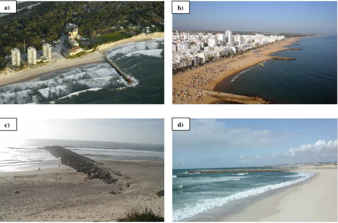
Figure 2.8: Groins in Portugal: a) Ofir; b) Lagos; c) Madeira; d) Espinho. 20
Figure 2.9: Sand engine (Deltares, 2013). 22
Figure 2.10: a) Oyster reef; b) Mussel reef. 22
Figure 2.11: a) Salt marshes; b) Mangroves; c) Osier-beds. 23
Figure 2.12: Reed floats (Deltares, 2013). 23
Figure 2.13: Eco concrete (Deltares, 2013). 24
Figure 2.14: Tidal pools (Deltares, 2013). 24
Figure 2.15: Formation of a tombolo in the leeward side of an emerged breakwater due to the
diffraction currents. 26
Figure 2.16: Schematic description of the effect of a submerged breakwater in the wave
propagation, Olympic Port, Barcelona, Spain (Taveira-Pinto and Neves, 2003). 27
Figure 2.17: Schematics of rip currents generated in the leeward side of a submerged breakwater
xvi Bárbara Vasquez Vieira
Figure 2.18: Cross section of a breakwater (Adapted from Costa, 2009). 28
Figure 2.19: Type of organic growth associated with rockfill structures and geotextiles. a) Rockfill;
b) Geotextiles. 30
Figure 2.20: Scheme for formation of tombolo and action of refraction (French, 2002). 32
Figure 2.21: Scheme for a salient and tombolo generation (Abbott and Price, 1994). 32
Figure 2.22: Scheme of diffraction caused by a detached breakwater (Silvester and Hsu, 1997). 32
Figure 2.23: Examples of sloping type breakwaters (Takahashi, 2002). 36
Figure 2.24: Examples of vertical type breakwaters (Takahashi, 2002). 37
Figure 2.25: Examples of horizontally composite breakwaters (Takahashi, 2002). 38
Figure 2.26: Examples of composite breakwaters (Takahashi, 2002). 39
Figure 2.27: Examples of special breakwaters (Takahashi, 2002). 40
Figure 2.28: Annual zoning of the seasonal variation of beach profile (adapted by Hallermeier,
1981). 43
Figure 2.29: Diagram illustrating tidal terms (adapted from LINZ, 2014). 44
Figure 2.30: Definitions of key variables for nearshore breakwater scheme: a) plan view, b) section
view (adapted from DEFRA, 2010). 45
Figure 2.31: Effect of breakwater length for different dimensionless tidal ranges (Rtidal⁄Hm0;
standing tides). 48
Figure 2.32: Effect of breakwater crest level (relative submerged depth at high water, dcr⁄Hm0) for
different breakwater length (Rtide⁄Hm0 = 2,5). 49 Figure 2.33: Existing design guidance for assessing possible shoreline erosion in the gaps between
nearshore breakwaters. 49
Figure 2.34: COULWAVE data framework (adapted from Douyère, 2003). 56
Figure 2.35: Files involved in a BOUSS-2D simulation. 67
Figure 2.36: Schematic representation of SMC (SMC, 2014). 69
Figure 2.37: Contours to avoid (adapted from SMC, 2014). 70
Figure 2.38: Representative scheme of the height of the berm, dB, and the depth of closure, hc
(Adapted from Simões et al., 2013). 74
Bárbara Vasquez Vieira xvii
Figure 3.2: North and South groins and Ofir towers location. 82
Figure 3.3: Time series of significant wave heights and annual percentage of valid records of 3 in 3
hours (Leixões 1993-2007) (Silva et al., 2008). 83
Figure 3.4: Relative frequency distribution of the significant wave height for the set of data
collected by the Leixões buoy station between 1993 and 2007 (Silva et al., 2008). 83
Figure 3.5: Shallow-Water Wave Calculator. 85
Figure 3.6: Wave heights as a function of return period (adapted from Taveira-Pinto, 1993). 86
Figure 3.7: Trimble Geo XR-6000 equipment. 86
Figure 3.8: Representation of the survey path for collecting data of beach morphology (solid line)
(on the left) and ArcGIS representation of the Ofir beach morphology and the contour lines (on the
right). 87
Figure 3.9: ArcGIS representation of the collected data of the Ofir beach and the Viana do Castelo
to Leixões contour lines. 87
Figure 4.1: Profile graph shown in ArcGIS. 97
Figure 4.2: Representation of the domain bathymetry. 100
Figure 4.3: Scheme representing the HAT, MSL and CD values for the Portuguese coast. 101
Figure 4.4: Coordinate system for wave orientation angles in degrees. 102
Figure 4.5: “Islands” created by the depth extrapolation (brown lines between blue lines). 102
Figure 4.6: Initial grid without detached breakwater (left) and depth, in meters, along the domain
without detached breakwater (right). 103
Figure 5.1: Output results for SC1. 111
Figure 5.2: Results and analysis for Initial scenarios. 112
Figure 5.3: Results and analysis for scenarios 1 to 12. 113
Figure 5.4: Results and analysis for scenarios 13 to 24. 113
Figure 5.5: Results and analysis for scenarios 25 to 36. 114
Figure 5.6: Results and analysis for scenarios 37 to 48. 114
Figure 5.7: Results and analysis for scenarios 49 to 60. 115
xviii Bárbara Vasquez Vieira
Figure 5.9: Results and analysis for scenarios 1 to 12. 119
Figure 5.10: Results and analysis for scenarios 13 to 24. 119
Figure 5.11: Results and analysis for scenarios 25 to 36. 120
Figure 5.12: Results and analysis for scenarios 37 to 48. 120
Figure 5.13: Results and analysis for scenarios 49 to 60. 121
Figure 6.1: Difference in significant wave heights results with and without a porosity boundary
(SC1 on the left and SC3 on the right). 128
Figure 6.2: Residual velocity in all beach domain (SC1). 131
Figure 6.3: Difference in significant wave height results between scenario Initial and scenario with
detached breakwater (Initial1 – SC1). 131
Figure 6.4: Difference in significant wave height results between submerged and emerged detached
breakwater scenario (SC3 – SC1). 131
Figure 6.5: Difference in significant wave height results between duo and solo detached breakwater
scenario (SC2 – SC1). 131
Figure 7.1: Observation points location for BOUSS-2D model. 140
Figure 7.2: Significant wave height results at three observation points in COULWAVE. 141
Bárbara Vasquez Vieira xix
LIST OF TABLES
Table 2.1: Structural types of breakwaters (Adapted from Takahashi, 2002). 35
Table 2.2: Parameters for determining incident wave and tide conditions used in the design curves
(DEFRA,2010). 46
Table 2.3: Parameters used for determining geometrical parameters of the breakwater (DEFRA,
2010). 47
Table 2.4: Dimensionless parameters that influence beach response in the vicinity of nearshore
breakwaters. 47
Table 2.5: Breaker type transition values for inshore Iribarren number. 53
Table 2.6: Files involved in COULWAVE (Lynett and Liu, 2014). 56
Table 2.7: Files involved in BOUSS-2D Simulation (Adapted from Demirbilek et al., 2005). 67
Table 3.1: Results obtained using the Gumbel distribution. 84
Table 3.2: Estimated limit depths. 84
Table 3.3: Basic data for determining the breakwater design parameters. 88
Table 3.4: Geometrical parameters of the breakwater (according to the calculation procedure
proposed by DEFRA, 2010). 89
Table 3.5: Form coefficient, K∆, according to different breakwater materials, slopes and shapes
(Taveira-Pinto, 1993). 91
Table 3.6: Stability coefficient, KD, according to different breakwater materials and shapes
(Taveira-Pinto, 1993). 92
Table 3.7: Slope angle with the horizontal, α, values for different breakwater materials
(Taveira-Pinto, 1993). 92
Table 5.1: Scenarios with the inclusion of detached breakwater. 108
Table 5.2: Scenarios without the inclusion of detached breakwater. 108
Table 6.1: Scenarios with the inclusion of detached breakwater. 126
Table 6.2: Scenarios without the inclusion of detached breakwater. 127
Table 6.3: Scenario analysis considered. 129
Table 7.1: Modelling conditions for COULWAVE and BOUSS-2D models. 139
xx Bárbara Vasquez Vieira (Page intentionally left blank)
Bárbara Vasquez Vieira xxi
ACRONYMS
1D One Dimensional
1DH One Dimensional in the Horizontal plane 2DH Two Dimensional in the Horizontal plane
3D Three Dimensional
ADCIRC Advanced Circulation
ADH Adaptive Hydraulics Modelling System
ArcGIS Aeronautical Reconnaissance Coverage Geographic Information System ASCII American Standard Code for Information Interchange
BOUSS-2D Boussinesq wave model for coastal regions and harbours CAD Computer-Aided Design
CD Chart Datum
CGWAVE General-purpose wave prediction model for simulating the propagation and transformation of ocean waves
CMS-FLOW Coastal Modelling System
CMS-WAVE Coastal Modelling System. Formerly known as WABED (Wave-Action Balance Equation Diffraction)
COULWAVE Cornell University Long and intermediate Wave DEFRA Department of Environment Food and Rural Affairs DHI Danish Hydraulic Institute
FESWMS Finite Element Surface Water Modelling System FVCOM Finite- Volume Coastal Ocean Model
GenCade GENESIS and Cascade combinational beach models GENESIS Generalized model for Simulating Shoreline charge GIS Geographic Information System GPS Global Positioning System
HAT Highest Astronomical Tide
H Significant wave height for a scenario Hi Significant wave height for Initial scenario Hydro AS 2D SMS model
IH Portuguese Hydrographic Institute (Instituto Hidrográfico) IPCC Intergovernmental Panel on Climate Change
xxii Bárbara Vasquez Vieira LAT Lowest Astronomical Tide
MFAR Multifunctional Artificial Reefs MHWN Mean High Water Neaps MHWS Mean High Water Springs MIKE 21 DHI software
MLWN Mean Low Water Neaps MLWS Mean Low Water Springs MSL Mean Sea Level
POOC Plans for the management of coastal zone PTM Particle Tracking Model
RANS RiverFlo 2D
Reynolds-averaged Navier Stokes SMS model
RMA2 SMS model maintained by the Army Corp of Engineers Engineering Resource Development Center
RMA4 SMS model maintained by the Army Corp of Engineers Engineering Resource Development Center
SC Scenario
SMC Software Sistema Modelado Costero SMS Surface-water Modelling System
SRH-2D Sedimentation and River Hydraulics- Two Dimensional model
STWAVE Steady-State finite difference spectral model based on the Wave action balance equation
SWAN Simulation Waves Nearshore TMA Shallow water spectrum TUFLOW SMS model
VBA Visual Basic for Applications WAM Wave prediction Model
CHAPTER 1
Introduction
‘The obstacle is the path.’
Bárbara Vasquez Vieira 1
CHAPTER 1
INTRODUCTION
1.1 Motivation of the work
1.1.1 The importance of coastal defence
Estuarine and coastal zones are highly dynamic systems. Morphodynamic behaviour of these systems is directly influenced by natural driving forces (e.g., waves, tidal currents, wind, river discharges and sea level changes) and human-induced impacts (e.g., coastal physiography modifications and modifications in sediment supply) (Dias et al., 2011). Understanding the fundamentals of the physical, chemical, biologic and anthropogenic complex phenomena inherent to the integrated study of estuaries and beaches is of paramount importance for coastal, human life and property protection.
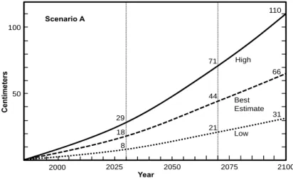
Projections presented by the Intergovernmental Panel on Climate Change (IPCC) indicate that global climate change may rise sea level as much as one meter over the next century (Figure 1.1) and, in some areas, increase the frequency and severity of storms (Gilbert and Vellinga, 1990). Consequences of this can result in the retreat of beaches as much as a few hundred metres and the rupture of protective structures. Flooding of hundreds of thousands of square kilometres of coastal wetlands and other lowlands would threaten lives, buildings, and infrastructures, as well as putting drinking water sources out of service due to salt intrusion in coastal aquifers. This way, functions and values of coastal zones are degraded with the related social and economic impacts. Consequently, populated coastal areas are becoming more and more vulnerable to sea level rise and other impacts of climate change.
Figure 1.1: Global sea level rise, 1985-2100 for policy of no limitation of greenhouse gases (scenario A) (Adapted from Houghton et al., 1990).
2000 2025 2050 2075 2100 50 100 Cent im et ers Year High Best Estimate Low 8 18 29 21 44 71 31 110 66 Scenario A
2 Bárbara Vasquez Vieira Facing the effects of sea level rise requires adequate responses in order to minimize impacts. One vital element of a plan to manage this phenomenon is to formulate and implement effective integrated coastal management programs. This was one of the recommendations of the IPCC and the 1992 Earth Summit in Rio de Janeiro. The implementation of such a plan implies the consideration of responses that fall broadly into four categories: retreat, accommodation, protection, and do nothing (Granja and Pinho, 2012).
Retreat involves no effort to protect the land from the sea. The coastal zone is abandoned and ecosystems shift landward. This choice can be motivated by excessive economic or environmental impacts of protection, and can include demolitions, relocations and compensations. In the extreme case, an entire area may be abandoned.
Accommodation implies that people continue to use the land at risk but do not attempt to prevent the land from being flooded. This option includes erecting emergency flood houses, elevating buildings on piles, converting agriculture to fish farming, or beach nourishment to adapt the overall coastal marine dynamics.
Protection involves hard structures such as seawalls, groins, breakwaters, and dikes, as well as soft solutions such as dunes and vegetation, to protect coastal segments when social and economic interests are justified.
Do nothing option allows the natural evolution of coastal marine dynamics.
Cost-benefit analysis must be applied in order to decide the appropriate mechanism for implementation. Particular response must consider social, economic, and environmental aspects of the coastal zone considered.
Improving scientific and public understanding of the problem is also a critical component of any response strategy. Basic and applied research are needed for better projections of changes in the rate of sea level rise, precipitation, frequency and intensity of storms, and coastal dynamics. Finally, in most of the countries the available information has many uncertainties due to unreliable data from which to determine how much coastal zones are at risk.
1.1.2 Management of coastal zones in Portugal
The Atlantic coast of Portugal is exposed to rough wave climate conditions and frequently submitted to powerful storms, endangering waterfronts, infrastructures and natural landscapes (Pereira et al., 2013). Main wave crest orientation is from the northwest, inducing a drift current
Bárbara Vasquez Vieira 3 from north to south. However, this current is, in some areas, reversed due to the presence of some natural (bars, ebb tidal deltas, rocky outcrops) and artificial (breakwaters, jetties, groins) obstacles that promote local wave diffraction (Granja and Pinho, 2012).
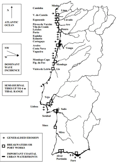
Sandy coastlines, without headlands or rocky foreshores are the most vulnerable Portuguese coastal units to erosion. Figure 1.2 depicts some examples on the Portuguese coast of intense urban development on unstable and environmentally sensitive areas and the existent erosion problems (Veloso-Gomes and Taveira-Pinto, 1997).
Figure 1.2: Portuguese coastal occupation and existent erosion problems. (Adapted from Veloso-Gomes and Taveira-Pinto, 1997)
The weaknesses of the coastal zone in Portugal are essentially due to the anthropogenic causes associated with urban and industrial occupation, river settlement interventions, dams, rise of the mean sea level and the frequency and intensity of storm events, as well as new accessibility (ports, motorways), traffic flows, and extraction of aggregates. These factors are the main responsible for reducing the amount of sediment transport along the coast, new hydrodynamic situations and major landscape changes.
4 Bárbara Vasquez Vieira Dunes have an important contribution not only in terms of slowing down the ocean’s advance, because they can act as a sand reservoir for beaches, but also in terms of protecting and recovering other natural values. The continued destruction of dunes and vegetation by trampling and by building housing and improvised parking lots prevent the accumulation of sand, thus contributing greatly to the instability of natural defences (Veloso-Gomes and Taveira-Pinto, 2003).
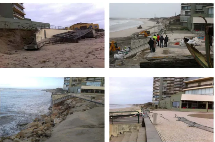
These phenomena are observed in storm situations that cyclically occur mainly in winter time along the Portuguese coastal zone (Figures 1.3 and 1.4).
Bárbara Vasquez Vieira 5
Figure 1.4: Flooding problems in the city of Póvoa de Varzim (storm of 2014).
In order to defend the urban areas and the land use, new solutions for coastal defence may be needed. However, these works may induce or anticipate other erosion problems southwards. The planning, design and construction processes of coastal structures must be based on information and knowledge of marine coastal dynamics and depend on the construction methods applied and on the characteristics of the available equipment.
Most people claim for coastal defences from the Government because they don’t want to lose their homes due to erosion. Simões et al (2013) explain that currently, there is already a concern to reset sediments on the beaches, both by feeding artificially and by building defence structures (detached breakwaters and groins along the coast, multifunctional artificial reefs, for example).
The implementation and assessment of Plans for the Management of the Coastal Zone (POOC) should be a key instrument for effective integrated management of the Portuguese coastal zones.
1.2 Objectives
This research work aims to apply hydroinformatic tools to simulate the influence of detached breakwaters on coastal zones, considering different conditions of hydrodynamics (wave height and period) and detached breakwater geometrical parameters. Also, the prediction of sediment transport in the vicinity of these coastal defence structures was analysed, considering results obtained for residual velocities associated with wave propagation. Within this main objective the following specific issues were addressed:
Comparative analysis of software solutions for coastal processes numerical simulation; Study of different types of detached breakwaters, materials and their impacts on the coastal
6 Bárbara Vasquez Vieira Assessment and identification of key variables in the design of detached breakwaters and
their influence on sediment retention;
Application of the developed methodology to the study site of Ofir beach, in the county of Esposende;
Data analysis of the bathymetry and morphology of the study site;
Construction of models and simulation of wave propagation scenarios to study the hydrodynamics and sediment transport patterns in the vicinity of detached breakwaters; Study of the variability of sediment transport and the significant wave height and wave
energy for different wave regimes and types of detached breakwaters (submerged or emerged);
Analysis of hydrodynamic patterns in the study site for different wave parameters (direction, significant height and period);
Analysis of the influence of detached breakwater geometric parameters (crest level, distance from shore to the detached breakwater, number and length of detached breakwaters and spacing between them) in the resulting significant wave height and wave energy; Analysis of the wave residual velocities fields in order to predict the sediment transport
patterns in the study site;
1.3 Methodology
To achieve the proposed objectives for this research work a Portuguese coastal stretch highly vulnerable to erosion (Ofir beach) was selected and the impact of a detached breakwater in the local hydrodynamics and sediment transport patterns was simulated for different scenarios.
The design of the simulated detached breakwater was obtained using UK Department of Environment Food and Rural Affairs (DEFRA, 2010) methodology based on bathymetric data obtained from field measurements and wave data collected at monitoring stations of the Portuguese Hydrographic Institute (IH).
To implement the numerical models it was studied the significant wave height extremes, as well as the determination of the depth of closure and the wave period associated considering a set of wave conditions data for a 14 year time period between 1993 and 2007.
COULWAVE (1DH) for hydrodynamics and BOUSS-2D for hydrodynamics and sediment transport were the selected software for models construction. Lynett and Liu (2014) demonstrated
Bárbara Vasquez Vieira 7 that COULWAVE model is a very accurate tool for the analysis of significant wave heights in the presence of detached breakwater, comparing experimental with numerical wave height results. BOUSS-2D also revealed to be a suitable numerical model to analyse the significant wave heights in a 2DH domain. Although this model does not output directly the sediment transport, it can be predicted by analysing the residual velocity field through the study domain.
Input data depend on the characteristics of each one of those models. The variables for the COULWAVE model were: the significant have height and its period; the crest level; and the distance from shore to the detached breakwater. For the BOUSS-2D model the variables considered were: the significant have height and its period; the crest level of the detached breakwater; and the wave direction. The combination of these variables determined different simulation scenarios. The simulation results were obtained considering different detached breakwaters scenarios. For 1DH model an Initial (without detached breakwater) condition and a situation with one continuous detached breakwater were simulated giving as output significant wave height and wave energy results. For 2D model an Initial (without detached breakwater) condition and two situations with one continuous and another discontinuous detached breakwater were simulated giving as output significant wave height and residual velocity fields results.
A sensitivity analysis for comparing relative accuracy between the two models was performed. Significant wave height results obtained with the 1DH and 2DH models were compared for the same wave height, domain and boundary conditions.
8 Bárbara Vasquez Vieira
Figure 1.5: Scheme of the adopted methodology.
1.4 Organization of the dissertation
The contents of this dissertation are organized according to the following chapters.
Chapter 1 briefly describes the motivation and objectives of this research work. It also highlights the importance of the coastal defence as well as the management of the coastal zones in Portugal. This is followed by the presentation of the main objectives, the methodology adopted throughout the dissertation and its structure.
Chapter 2 indicates and describes some of the different types of technical solutions for coastal defence and the current coastal defence situation in Portugal. It also focus the general aspects and the design conditions for detached breakwaters, their geometry, the most widely used materials and the functional parameters that are crucial for the effectiveness of a detached breakwater. In addition, it is described the influence of the hydrodynamics and the mechanisms of sediment transport induced by the presence of a detached breakwater, its consequences and impacts, the global classification of the structural types of breakwaters and the description, application and limitations
Bárbara Vasquez Vieira 9 of different hydroinformatics tools that can be used in coastal defence solutions modelling and analysis.
Chapter 3 presents a general description of the study area (Ofir beach) and the effects of a detached breakwater on coastal areas. Further, an analysis of the collected data for a period of 14 years by the Leixões buoy is made and the hydrological parameters needed to the design of a detached breakwater are highlighted and determined. This Chapter also includes a description of the tidal parameters used in this dissertation, the bathymetry and its slope and the calculations for determining the geometric parameters of a reference detached breakwater.
Chapter 4 describes in detail the implementation of the numerical models (COULWAVE and BOUSS-2D).
Chapter 5 presents results obtained with the 1DH COULWAVE model in a specific scenario. Also, the discussions of the results for significant wave heights and wave energy in scenarios with and without a detached breakwater are presented. The remaining results are included in Appendices 2 to 6.
Chapter 6 presents results obtained with the model implemented with BOUSS-2D. Also, the discussions of the results for significant wave height and residual velocity fields in different scenarios considering the presence or not of a detached breakwater are presented. The remaining results are included in Appendices 8 to 11.
Chapter 7 presents a comparison of the results obtained in a theoretical example for significant wave height with COULWAVE and BOUSS-2D at the same three locations of the domain for the same wave height and boundary conditions, and presents the conclusions of this work and the suggestions for future developments.
A list of the bibliographical references cited along the text is presented.
Appendices 1 to 11 contain simulation results, a programming code and details of software input data files.
CHAPTER 2
State of the art
‘Sometimes it's necessary to go a long distance out of the way in order to come back a short distance correctly.’
Bárbara Vasquez Vieira 13
CHAPTER 2
STATE OF THE ART
2.1 Technical solutions for coastal defence
In a zone prone to shoreline retreat due to high tide/wave energy action without natural defence and a high sediment transport deficit, many different solutions can be used to reduce or to control coastal erosion, namely: adherent works, transversal works, beach nourishment, sand bypassing and dunes rehabilitation, creating innovative and alternative breakwaters designs and, specially, ‘environmental-friendly’ structures (Taveira-Pinto and Neves, 2004).
It is important to highlight that the existence or the possible construction of defence structures should not be used as an excuse to allow building in areas of risk. These structures may locally reduce risks of exposure to sea action, but do not eliminate them. Each of these approaches has economic, aesthetic, environmental and human advantages and disadvantages and the choice of the solution will vary widely according to local, regional and national priorities (Veloso-Gomes and Taveira-Pinto, 1997).
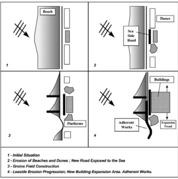
A typical coastal urban area evolution is represented in Figure 2.1.
Figure 2.1: Coastal urban area: typical evolution (Veloso-Gomes and Taveira-Pinto, 1997).
In the next sections general characteristics of most usual coastal defence technical solutions (breakwaters, groins and eco-engineering solutions) will be briefly described.
14 Bárbara Vasquez Vieira
2.1.1 Breakwaters
Breakwaters are constructed to provide a calm basin for ships and to protect harbour facilities. They are also sometimes used to protect the port area from the intrusion of littoral drift. In fact, for ports open to rough seas, breakwaters play a key role in port operations. Since sea waves have enormous power, the construction of structures to mitigate such power is not easily accomplished (Takahashi, 2002).
The breakwaters can take many forms and can be permanently submerged (reefs), permanently exposed or visible between tides. These structures can be adherent (rooted and/or located against the coast), detached (built away from the coast), or may have a one end anchored to the ground (acquiring usually a curved or an L shape: headland breakwaters). In all cases, the depth of the structure, its size and its position relative to the shoreline determine the level of protection provided (Antunes do Carmo et al., 2011).
2.1.1.1 Headland breakwaters
A series of breakwaters constructed in an "attached" fashion to the shoreline and angled in the direction of predominant wave approach such that the shoreline behind the features evolves into a log spiral embayment (USACE, 2014a). Figure 2.2 depicts some examples of these kinds of structures.
Bárbara Vasquez Vieira 15
Figure 2.2: Examples of headland breakwaters.
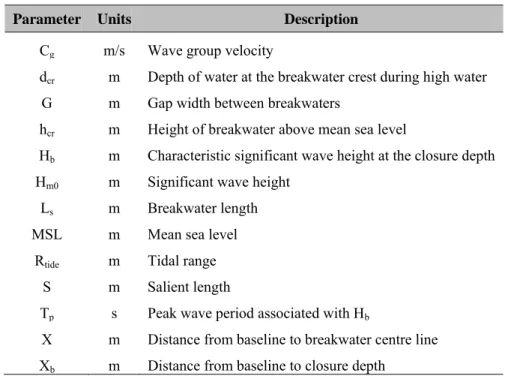
2.1.1.2 Detached breakwaters
Detached breakwaters are another example of coastal defence structures that are built offshore inside/near the surf zone, having an approximate orientation parallel to the coast built in shallow nearshore environments and that can be, according to their position relatively to the mean water level, emerged or submerged (Figure 2.3). Both constitute an obstacle to the normal wave propagation, allowing the dissipation of the incident wave energy and providing a “filter” shelter for the coast at their leeward side, reducing this way beach erosion. These structures also function well in areas where the cross-shore current, or shore-perpendicular transport of materials, is stronger as the structures will provide greater protection of original beach material while capturing new sediments entering the system.
As the waves approach the shore, the breakwaters reduce the energy of the waves, creating a calm environment on the leeward side of the structures. This environment is ideal for the deposition of sediment which in turn aids in retaining and enhancing beach width and thickness (ODNR, 2011). During the design process of these structures, it is important to consider the wave-structure interaction, defined by their functional parameters (e.g.: length, orientation and distance to the shoreline), that establish their efficiency.
The submerged breakwater is also a particularly attractive solution for the creation and preservation of beaches, due to its low environmental and visual impact (Figure 2.4). Inherent to the improvement of water quality, maintenance of fish habitats due to its lower impact of coastal development on aquatic habitat and a better integration of the coastal defence structure in the shore zone, are examples of the advantages of submerged breakwaters over the conventional structures (Taveira-Pinto and Neves, 2003).
16 Bárbara Vasquez Vieira The main technical characteristics of detached breakwaters are described in detail in Chapter 2.2.
Figure 2.3: Examples of detached breakwaters.
Figure 2.4: Examples of submerged breakwaters.
2.1.1.3 Artificial reefs
Across the world, certain types of artificial reefs generally built in mid to deep waters are seen as a management tool to sustain coastal fisheries to preserve marine life (Figure 2.5). In Portugal, the same types of artificial reefs are more used in the region of Algarve (one of the largest in Europe with an area of about 43 km2) in order to avail the productive potential of surface currents because of their richness in nutrients and because it is a propitious area to natural coastal accidents (Whitmarsh et al., 2008). Locations of these areas are shown in Figure 2.6.
Bárbara Vasquez Vieira 17
Figure 2.5: Artificial reefs.
Figure 2.6: Artificial reefs in the Algarve (OR, 2014).
In California (United States) an artificial reef was built in 2001 at Dockweiler beach, which eventually was removed in 2008 for not complying with the intended goals. On the South coast of England, Boscombe area, in 2008, a reef was built in order to increase the number of visitors, to extend the tourist season and promote economic growth. However, after two years the construction of the reef has suffered significant damage, which derailed the effects of protection, particularly in terms of accumulation of sediments (Antunes do Carmo, 2013).
18 Bárbara Vasquez Vieira
2.1.1.4 Multifunctional artificial reefs
The multifunctional artificial reefs (MFAR) is a particular case of artificial reefs and represent an innovative concept for coastal protection. In addition to have this function these artificial reefs create favourable conditions for the practice of surf, favouring other sporting activities such as diving and fishing, and enhance the environmental value of the area where they are located. MFAR provide a perfect visual amenity and can offer tourism and economic benefits to the region where they are installed (Antunes do Carmo et al., 2011).
The construction of a MFAR may play an important role in different aspects of coastal protection, namely:
Prevention of coastal erosion;
Increase of sand deposition in combination with artificial nourishment, and increase of beach stability;
Reduction of the wave load on the coast through a series of processes of transformation of wave occurring on the structure (reflection, refraction and energy dissipation);
Use for control waves propagation, creating good surfable waves, due to refraction and diffraction effects.
More recently, MFAR have been proposed typically installed in shallow waters with coastal protection goals, particularly in protection of beaches and dunes, and in generating waves for surfing. In this context, arise as examples: the artificial reef in Cable Station (near Perth), built in 1999, and artificial reef at Narrowneck Beach (Gold Coast) built in 2000, both located in Australia. In New Zealand, Maunganu Beach, was built in 2008 a MFAR using geotextile bags filled with sand with the main objective of improving local conditions for surfing.
In India, in 2010, the multifunctional reef Kovalam was built, which proved a case of great success to prevent coastal erosion and to generate great waves for surfing (Simioni and Esteves, 2010). In Portugal there are still no MFAR, although the several studies for its implementation in some areas of the Atlantic coast, particularly in locations that require urgent protection measures and which are judged to be likely to benefit from good conditions for surfing. Examples are the coastal zones of São Pedro do Estoril (Mendonça et al., 2010), Leirosa, south of Figueira da Foz (Voorde et
al, 2009; Antunes do Carmo et al. 2011; Mendonça et al., 2012) and Vagueira beach (Simões et al.,
Bárbara Vasquez Vieira 19
2.1.2 Groins
Groins are the oldest and most commonly beach stabilisation structure used on shore. They are structures that extend, fingerlike, perpendicularly to shoreline and that are relatively short when compared to navigation jetties. Usually constructed in groups called groin fields, their primary purpose is to trap and retain sand, nourishing the beach compartments between them.
Groins work as physical barriers to the alongshore transport of sand, that starts to accumulate up-drift (Figure 2.7). They are most effective where longshore transport is predominantly in one direction, and where their action will not cause unacceptable erosion of the downdrift shore. When a well-designed groin field fills to capacity with sand, longshore transport continues at about the same rate as before the groins were built, and a stable beach is maintained. Modern coastal engineering practice is to combine beach nourishment with groin construction allowing sand to immediately begin to bypass the groin field system, reducing transient erosion downdrift (USACE, 2014b).
Figure 2.7: Schematic representation of the functioning of groins.
The volume of sediments accumulated updrift from the groin is a function of its dimensions, wave conditions and sediment grain size, being indicative of the erosion contention. If the limiting retention capacity of the groin is reached it stops blocking sediments, letting them pass through. The time elapsed to fill a groin depends on several factors, like wave conditions at the groin location, beach morphology, tide regime and even current pattern in the surrounding area (Silva et al., 2007). Therefore, the filling time would be given by the ratio between the accumulated volume and the alongshore transport rate. It is important to be aware that although it may appear simple, both accumulated volume and alongshore transport are difficult to evaluate.
Longshore Transport Direction
Updrift Sediment Build up (Accretion) Updrift Side of Groin Groin
Longshore Transport Direction Original shoreline
Dowdrift Side of Groin Erosion
20 Bárbara Vasquez Vieira A very negative impact that would result from these works, if they had the capacity of inducing rip currents, would be the irreversible loss of sediments dragged to offshore. Short groins cannot jet material far offshore and permeable groins reduce the rip current effect. However, long impermeable jetties might produce large rips and jet material beyond the average surf zone width. Affirming that groins erode the offshore profile is questionable and doubtful. Under this perspective, groins should be permeable, allowing water and sand to move alongshore, and reduce rip current formation and cell circulation (Silva et al., 2007). Examples of existing groins in Portugal are presented in Figure 2.8.
Figure 2.8: Groins in Portugal: a) Ofir; b) Lagos; c) Madeira; d) Espinho.
2.1.3 Eco-engineering solutions
Eco-engineering solutions improve traditional structures using natural resources to increase the structure functionality, or the use of natural materials (flora and fauna) to create structures. In the last decade, management and development of wet nature values of dikes has been incorporated in Dutch policies, and several concepts for ‘green’ dikes and submerged reefs have been developed. To further improve the ecological value of hard substrates, the Dutch Ministry of Public Works and Water Management WINN-project ‘Diverse Dike’ was initiated in 2007. The project aims for the
a) b)
Bárbara Vasquez Vieira 21 design of ecologically diverse coastal defence structures, dikes, dams, piers and groins, on a base of ecological functions. Safety against floods naturally plays a central role, but additionally the recreational value of the coastal environment can be improved as well. The concept has been developed in an intensive cooperation of ecologists and civil hydraulic engineers, and the designs are meant to be economically and practically feasible as part of existing or new designs for coastal infrastructure (Deltares, 2014a).
Eco-engineering is important because it creates a more natural environment, with a habitat for all kinds of organisms and possibilities.
Bio-Builders are organisms that naturally occur in the relatively shallow waters along the coast and in inland waters, and that are capable of changing their environment in a way favourable to themselves. Thus, as water levels vary due to climate change, the bio-builders can adapt to the variations and maintain their function of coastal protection. Furthermore, eco-engineers grow naturally, which means that construction costs can be limited, as are costs for maintenance and repair. By means of their activity, they play a crucial role in the cycle of all kinds of substances in the water: Some filter water so it becomes clearer, others assimilate substances so that these form a food source for other organisms. In this natural way, the water quality can be improved against much lower costs than what would be possible with chemical or mechanical purification.
Hard substrates are home to the most species diverse communities of all coastal systems in many world locations. Sea dikes and levees are a habitat to many, sometimes rare species and can contribute greatly to their dispersal. By enhancing the establishment possibilities for sea animals and plants like mussels, oysters, barnacles, algae and anemones, the ecological function of hard substrates can be significantly improved. (Deltares, 2014a).
2.1.3.1 Sand engine
Sand nourishment allows natural processes to maintain a sandy coast and ‘dynamically’ keep it in place (Figure 2.9). The sand for nourishment is dredged from deep waters (below the 20-metre depth contours). Water and wind distribute this sand naturally along the beach and across the dunes (Deltares, 2013).
22 Bárbara Vasquez Vieira
Figure 2.9: Sand engine (Deltares, 2013).
2.1.3.2 Oyster and mussel reefs
Reefs of bivalves can function as stabilising or protecting agents because they reduce wave and current intensity, and because of their ability to alter properties of the sediment. Figure 2.10 shows an oyster and a mussel reefs (Deltares, 2014a).
Figure 2.10: a) Oyster reef; b) Mussel reef.
2.1.3.3 Salt marshes, mangroves and osier-beds
Vegetated areas, such as salt marshes, mangroves and osier-beds (Figure 2.11), trap sediment by reducing flow velocities, by reducing hydrodynamic forces on the seabed and by improving consolidation of muddy soils by means of evaporation. Furthermore, they attenuate waves in front of coastal protection constructions, meaning that these require less height, enforcement and repair (Deltares, 2014a).
Bárbara Vasquez Vieira 23
Figure 2.11: a) Salt marshes; b) Mangroves; c) Osier-beds.
2.1.3.4 Reed floats
In areas that are initially not suitable for bottom vegetation, for instance due to the lack of shallow shores or large variations in water levels, floating devices often are applicable (Deltares, 2013). Reeds do not affect the sediment stability directly, but do attenuate small waves and thereby protect nearby banks, prevent re-suspension of bed material and improve water clarity (Figure 2.12).
Figure 2.12: Reed floats (Deltares, 2013).
a) b)
24 Bárbara Vasquez Vieira
2.1.3.5 Eco concrete
Much marine life, such as mussels, barnacles and seaweed, need a hard surface to survive. Commonly, they find this surface on hydraulic engineering constructions, such as harbour piers and seawalls. But modern concrete is becoming increasingly smooth and therefore less suitable for these organisms to establish themselves. The use of special ‘eco concrete’ during the construction or renovation of hydraulic engineering structures appears to significantly speed up the process by which these species establish themselves and their diversity (Figure 2.13) (Deltares, 2013).
Figure 2.13: Eco concrete (Deltares, 2013).
2.1.3.6 Tidal pools
Solid constructions along the coast, such as dikes, harbour piers and dams, are the habitat of various marine species (Figure 2.14). Many of them live exclusively in places that are continuously underwater. By making simple and inexpensive adjustments to solid structures, water in higher parts of the intertidal zone will linger longer. This can be a huge boost to biodiversity and biomass and can be used as a mitigating measure for Natura 2000 objectives (Deltares, 2013).
Bárbara Vasquez Vieira 25
2.1.4 The Portuguese coastal defence situation
In Portugal, several different types of coastal defence structures have been built: frontal defences, groins, jetties, seawalls, breakwaters and cliff reinforcements. These structures are mainly concentrated in the Northwest coast due to the fact that this region is highly energetic with a wave regime typically from Northwest, characterised by a mean significant wave height of 2m and a mean period of 12s. Storms, occurring especially in the winter, come predominantly from Northwest with offshore significant wave heights that may reach 8m persisting for up to 5 days. The tide regime is semi-diurnal with a tidal range between 2m and 4m in spring tides. The potential alongshore transport mainly due to the wave action is approximately 1-2 million m3/year (Oliveira, 1997).
The energetic Portuguese west coast wave climate requires a maintenance program that involves high investments throughout their life cycle. When these investments are not made, serious damage occurs to the structures, particularly during storm events. Artificial nourishment is not compatible with Portuguese west coast dynamics and nourished beach sediments are rapidly lost. But neither do groins nor revetments stabilize the coast or reduce erosion. On the contrary, they have contributed to the acceleration of erosion rates in several coastal stretches and their financial costs were very high (Granja and Pinho, 2012).
Detached breakwaters which have the potential to promote tombolo building seem to be a less harmful hard solution. While they might create local ‘solutions’, however, they contribute to downdrift erosion.
There are not many experiences with submerged or detached breakwaters in the Portuguese coast but it can be referred four cases, where these structures were used: in Leixões harbour as a submerged breakwater (protecting the main structure), in Caxinas-Vila do Conde beach, near Neiva’s river mouth, in Aguda beach and in Algarve region.
26 Bárbara Vasquez Vieira
2.2 Detached breakwaters
2.2.1 General aspects
2.2.1.1 Emerged breakwaters
Emerged detached breakwaters are designed to attenuate the whole wave action and are submitted to the direct impact of wave breaking, resulting in larger structures that often eliminate water circulation at the leeward side (in the protected area). Consequently, degradation of water quality and of natural habitats in the leeward side is a frequent phenomenon (Taveira-Pinto and Neves, 2003).
A disadvantage of emerged breakwaters, in terms of environment, is the necessity of gaps between the barriers that often give rise to rip currents, bed irregularities and tombolos. Figure 2.15 depicts the format of a tombolo near an emerged breakwater.
Figure 2.15: Formation of a tombolo in the leeward side of an emerged breakwater due to the diffraction currents.
2.2.1.2 Submerged breakwaters
Submerged breakwaters could be constructed by several reasons, being the most common purposes the following (Taveira-Pinto and Neves, 2003):
Beach protection caused by the wave dissipation/attenuation “shelter” effect;
Creation of a calmer zone in an harbour, protecting them or preventing siltation in port access ways;
Protection of a main structure by reducing the intensity of wave action on the principal coastal defence structure;
Bárbara Vasquez Vieira 27 Redistribution of sediment transport patterns, to create desirable beach features or alteration
of the sediment deposition area in a navigation channel entrance.
Figure 2.16 demonstrates the main objective of a submerged breakwater: the capability for retaining or permitting sediment accumulation at its leeward side responsible for its important role in beach protection. This sediment accumulation is due to the attenuation of the wave height, caused by the energy dissipation and the formation of diffraction figures at the ends of the structure. Figure 2.17 illustrates the diffraction currents formed in the extremities of the submerged breakwater (Taveira-Pinto and Neves, 2003).
Figure 2.16: Schematic description of the effect of a submerged breakwater in the wave propagation, Olympic Port, Barcelona, Spain (Taveira-Pinto and Neves, 2003).
Figure 2.17: Schematics of rip currents generated in the leeward side of a submerged breakwater (Adapted from Browder, 1996).
The efficiency of a breakwater is influenced by many variables: bathymetry, wave climate, sedimentation, implantation depth, length, distance to the coast, gaps between structures, submergence level and length and submerged breakwaters structural configuration. Since there are many unknown processes and variables involved, the study of these kinds of structures is more complex than studying emerged breakwaters (Taveira-Pinto and Neves, 2003).
Offshore
Beach
Onshore directed mass transport BreakwaterSubmerged Return Flow Diverted Alongshore
28 Bárbara Vasquez Vieira Chen and Chen (2001) found that as the length of breakwater increases, so does the reducing effect on wave height. They also verified that the wave height near the breakwater increased as the height of the submerged structure increased; when waves passed the breakwater, the wave height decreased as the height of the submerged breakwater increased.
Submerged breakwaters are less subjected to wave action because of their lower height and low visual and environmental impact. Besides that, the required volume of material is smaller than in similar emerged structures. However, it is important to be aware that submerged breakwaters have, obviously, a lower level of protection, since its efficiency in the formation of tombolos is lower. In some cases, however, it was concluded that the submerged structures dissipated wave energy more efficiently than the emerged ones (Taveira-Pinto and Neves, 2003).
2.2.2 Geometry of detached breakwaters
Figure 2.18 shows an example of a cross section of a possible detached breakwater scheme. In general, the section of a detached breakwater is not very different from a rubble mound breakwater, containing the following elements (Costa, 2009):
Resistant cloak: exposed slope zone that receives the direct action of agitation, composed of two layers of artificial or natural blocks;
Intermediate cloak: designed to prevent the escape of fine sediments from the core, comprises rows of decreasing diameters towards the inside of the breakwater. Geosynthetics like geotextile material type can be used to help accomplish this task;
Core: inner zone of the breakwater;
Toe: shot below the base of the cloak sturdy support and prevents infrastructure excavations.
Bárbara Vasquez Vieira 29
2.2.3 Materials
The most used material in the construction of detached breakwaters is the rockfill. This happens mostly for its more affordable when compared with concrete blocks and because of their good quality and resistance against agitation (rockfill is more resistant than concrete to agitation and also lasts longer). Another important advantage of rockfill is the possibility of reducing the negative environmental impacts. It may allow attachment of marine species (Challinor and Hall, 2008), creating a new habitat on the breakwater if the rockfill is similar to geological characteristics of materials of the intervention zone (Figure 2.19 a)). In absence of rockfill material in the intervention zone, concrete solutions such as tetrapods, cubic blocks, or Antifer ™ blocks, among other patented blocks are also commonly used.
The use of geosynthetics is also important because it can serve to protect the base of the slope excavation infrastructure, as also applies to separate the various layers of the slope.
The blocks of rockfill are normally acquired in quarries, depending on the weight they need to resist to the actions that will be performed on them. The block of precast concrete feature patented several forms, varying the geometry, size and weight (C.E.M., 2008). The major differences between them are related to its permeability when the blocks are arranged together, and thus to its ability to dissipate energy. Another distinguishing factor among the various patents relates to stability of the blocks, as well as the entire structure.
Due to the scarcity of materials and/or the high price involved in this type of solutions, several alternative materials such as tires, carcasses of cars/buses, among others, were used in several places on the planet. However, the impacts for the environment and the requirements of structural stability are factors driving demand for viable alternative materials (CIRIA/CUR, 2007).
More recently, coastal defence works using geotextiles (Figure 2.19 b)) whether in the form of bags, containers or pipes have been built. These containers, ranging in size, are filled with sediment captured in rocks. Although there is still some reluctance in using these materials related to their long-term durability when exposed to ultraviolet, or radiation exposure to human action, there are already several cases where geotextiles were successfully used in coastal protection works or stabilization (Dubai and Australia as the most publicized cases). Because the durability of geotextiles decreases when exposed to ultraviolet radiation, the use of such material is best suited to underwater structures where the effect of such radiation is less intense. The fact that they are submerged is an advantage, decreasing exposure to wave action and the need to maintain the
30 Bárbara Vasquez Vieira detached breakwater. Another advantage is the fact that it is under water what makes this material less susceptible to damage by human actions (Nunes, 2012).
Figure 2.19: Type of organic growth associated with rockfill structures and geotextiles. a) Rockfill; b) Geotextiles.
Fauna and flora impacts, due to using geosynthetic as material in the construction of marine works have also been accompanied and studies have shown that this type of material contributes to the increase of biodiversity of species implantation sites, as well as for the proliferation of the species (Corbett et al., 2010).
In conclusion, the choice of material to use holds up much to their availability at the implantation site, with the cost associated with the material, and associated with the detached breakwater functionality.
2.2.4 Functional parameters
Along with the wave conditions of the site concerned, the functional parameters are crucial to the effectiveness of any coastal defence structure. The submergence of the breakwater and the transmission coefficient (related to the crest width, its submergence and wave climate) are two examples of these parameters.
The transmission coefficient is determined by the balance between the energy of the incident wave (immediately before the breakwater) and the energy of the transmitted wave (immediately after the breakwater), being the wave energy directly related to the wave height. In the case of submerged breakwaters, it is considered that the energy transfer is dominated by the dissipative effect of the surf wave and for emerged breakwaters, where overtopping is not admissible, the power transmission through the structure is what most affects the transmission coefficient (Nunes, 2012).