REGIONAL CIRCULATION DIFFERENCES BETWEEN A RAINY EPISODE AND A NONRAINY
EPISODE IN EASTERN SÃO PAULO STATE IN MARCH 2006
PRAKKI SATYAMURTY
1,2, SERAFIM BARBOSA DE SOUSA JR
1, MATEUS DA SILVA TEIXEIRA
1,3e
LUCIA ELIANE MARIA GULARTE DA SILVA
41
Centro de Previsão de Tempo e Estudos Climáticos / Instituto Nacional
de Pesquisas Espaciais (CPTEC/ INPE), Cachoeira Paulista - SP
2
Instituto Nacional de Pesquisas da Amazônia (INPA), Manaus - AM
3
Instituto de Pesquisas Meteorológicas, (UNESP), Bauru - SP
4
Instituto Nacional de Meteorologia, Manaus, AM
[email protected]
Received Fevereiro 2007 - Accepted Março 2008
ABSTRACT
The differences between the regional low characteristics of a rainy episode and a nonrainy episode in March 2006 in eastern São Paulo state are discussed. The surface humidity and temperature characteristics do not show signiicant differences between the two cases. The composites of the middle tropospheric geopotential ield and the lower-tropospheric wind ield show a short-wave trough in the Atlantic off southern Brazil during the rainy episode. In the upper troposphere, the Bolivian high is stronger during the rainy episode than during the nonrainy episode, indicating that the troposphere over tropical South America is warmer during the rainy episode. The low-level jet in the rainy case does not penetrate northern Argentina, and is more NW-SE oriented, indicating that the humidity transport is more toward the southeastern Brazil. The moisture lux convergence over the eastern São Paulo at the 850-hPa is fairly strong in the rainy case whereas it is divergent in the nonrainy case. The presence of a low pressure area in the South Atlantic with westward tilt in the vertical provides synoptic forcing for the rising motion over eastern São Paulo state. These differences seem to be useful indicators for distinguishing rainy and nonrainy episodes.
Keywords: Rainy episode, Non-rainy episode, State of São Paulo
RESUMO: DIFERENÇAS NA CIRCULAÇÃO REGIONAL ENTRE UM EPISÓDIO CHUVOSO E UM EPISÓDIO NÃO-CHUVOSO NO LESTE DO ESTADO DE SÃO PAULO EM MARÇO DE 2006.
As diferenças nas características do escoamento atmosférico regional entre um episódio de chuva e outro de não-chuva sobre a parte leste do estado de São Paulo durante março de 2006 são discutidas. Os compostos dos campos de umidade e temperatura próximos à superfície durante os dois episódios distintos não mostram diferenças signiicativas. Os compostos de geopotencial em 500-hPa e ventos na baixa troposfera mostram um cavado de onda curta no Atlântico a leste da costa da Região Sul do Brasil durante o episódio chuvoso. O jato de baixos níveis tem uma orientação noroeste-sudeste sobre o norte da Bolívia durante o episódio chuvoso, indicando que o transporte de umidade é dirigido para a região Sudeste do Brasil. A convergência do luxo de umidade na baixa troposfera sobre a região de chuva é moderada, enquanto que no episódio não chuvoso o luxo é divergente. Na alta troposfera a Alta de Bolívia é mais intensa e os ventos fortes sobre a Região Sul do Brasil são de sudoeste, durante o episódio chuvoso, indicando que a troposfera é mais quente sobre a América do Sul durante o episódio chuvoso. A presença de uma região de baixa pressão no Atlântico, com uma inclinação na vertical para oeste, constitui uma forçante de escala sinótica para movimento ascendente necessário para atividade convectiva. Estas diferenças devem ajudar os meteorologistas para distinguir os episódios chuvosos e não chuvosos.
1. INTRODUCTION
The eastern parts of São Paulo state receive considerable amounts of rainfall in March, the month following the three-month rainy season December through February (Rao and Hada 1990). The March rainfall has special signiicance for the region because a large number of disasters associated with rainfall, such as soil erosion, loods and mudslides, are registered in this month. The rainfall in March is more episodic, unlike the rainfall in the rainy season, which tends to be more continuous. Moreover, during the transition month of March the variability of rainfall is larger than the variability in the rainy season months DJF. This variability is essentially due to the intraseasonal variability of regional circulation features. Understanding of the intraseasonal variability of rainfall is important for extending predictability beyond short-range forecasts. Medium-range (beyond 72 hours) forecasts are especially important for eastern parts of São Paulo state, which is a densely populated and highly industrialized mountainous region.
Eastern São Paulo, including greater São Paulo city, receives heavy rainfall during active South Atlantic Convergence
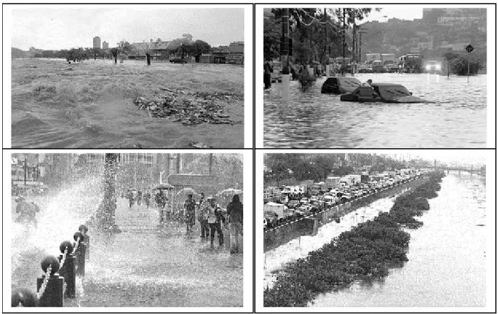
Figure 2 – Some scenes of loods and mudslides on 10 March 2006 in São Paulo.
Zone (SACZ) episodes in the months of November through March. When the soil in the mountain slopes is saturated with water during the rainy season (DJF), more-than-normal rainfall in March proves to be disastrous for the region. Therefore, meteorologists must keep vigil on the March rainfall in the city of São Paulo and in the Vale do Paraiba and Serra de Mantiqueira regions.
In March 2006, the rainfall in eastern São Paulo was more than normal in many places, especially in the city of São Paulo. There were some episodes of heavy rain and some with very little rain. Figure 1 shows the daily distribution of rainfall in the city of São Paulo (Mirante de Santana Meteorological Station) for the month of March 2006. It is very clear from the igure that the period 02-11 received copious amounts of rainfall while the period 12-15 did not receive any. The rainfall on the 10th (accumulated in the 24-hour interval from 09 LT on the 10th to 09 LT on the 11th) was very heavy and many places in and around the city of São Paulo were affected by loods and mudslides which disrupted the normal life of the population. Actually, there were many reports of disasters during the month of March 2006 in the media. Figure 2 shows some pictures of the disasters registered on 10 March 2006.
The objective of the study is to obtain the atmospheric circulation differences between the contrasting episodes, in terms of rainfall, during March 2006. This is a irst step to
understanding what characteristics of the atmospheric circulation are essential for making an episode a heavy rainfall episode. So far, such differences are not studied by the meteorologists of the region even qualitatively. These differences will possibly help the meteorologists to identify precursors of heavy rainfall in southeastern Brazil during the transition month of March.
2. DATA AND METHODOLOGY
The daily rainfall data for March 2006 and the monthly normals for the stations São Paulo, São José dos Campos, Campos do Jordão and Ubatuba, are obtained from the Instituto Nacional de Meteorologia (INMET, National Institute of Meteorology). These data are used for the characterization of the March 2006 rainfall in relation to the climatology and the rainy-season rainfall.
The rainfall in southeastern Brazil is mainly from frontal activity and the SACZ (which is viewed as a stationary
front) formation. In order to compare the daily rainfall data with the frontal activity the frontal incursion data is obtained from Climanálise which presents graphically the northward progression of cold fronts along the east coast of South America.
The daily 00 UTC and 12 UTC data sets for the surface pressure and temperature, the geopotential at 500-hPa level and the winds and humidity in the lower troposphere and winds in the upper troposphere are obtained from the NCEP-NCAR analyses (Kalnay et al. 1996). These data sets, with a resolution of 2.5º longitude x 2.5º latitude, are used to obtain the composites of the atmospheric variables for a rainy episode and a nonrainy episode in the eastern parts of São Paulo. As all datasets the NCEP reanalyses have many problems too. As there are very few synoptic and upper air meteorological stations over tropical and subtropical South America, the reanalysis data mainly represent the satellite observations and the global model behavior. Any increase in resolution of the data will not improve the quality of the analysis signiicantly, as the high-resolution data set is just a re-rendering of the original data by
interpolation methods. Moreover, for a study of the ive-day long episodes the resolution of 2.5º latitude by 2.5º longitude is not altogether insuficient.
The composites of an episode are obtained by simply taking the average of the 00 UTC and 12 UTC reanalysis over ive days of the episode, for the following ields: (1) sea-level pressure (ps), (2) sea-level temperature (Ts), (3) 850-hPa wind (V850), (4) 500-hPa geopotential (f500), (5) 200-hPa wind (V200), (6) thermal advection (-V.sT) at 850-hPa, (7) humidity transport (qV) and (8) convergence of humidity (-s.{qV}) at 850-hPa. The symbols used above have their usual meaning. The relevance of these variables to study meteorological circulations associated with rainy and nonrainy episodes is briely explained in the following lines. It is well known since the beginning of the last century that synoptic scale meteorological activity is associated with low-pressure centers at the surface. Sea-level temperature affects convective activity such that anomalously higher temperatures near the surface cause rising motion of air that is needed for the formation of rain. The 850-hPa wind ield shows the position and orientation
of low level jets which are conveyer belts of sensible and latent heat. Midtropospheric troughs and ridges and the upper tropospheric jetstreams are good indicators of the position and intensity of extratropical synoptic systems. Thermal advection ield in the lower troposphere diagnoses the frontal activity. The transport of humidity ield indicates the region from where the water vapor is brought and the convergence of humidity quantiies the amount of moisture available for moist convection. Moisture convergence or divergence in a given vertical column mostly occurs in the lower troposphere, as there is very little moisture above 500 hPa. In this study, the moisture transport and convergence at 850-hPa level are considered to represent the entire column.
3. CHARACTERIzATION OF PRECIPITATION
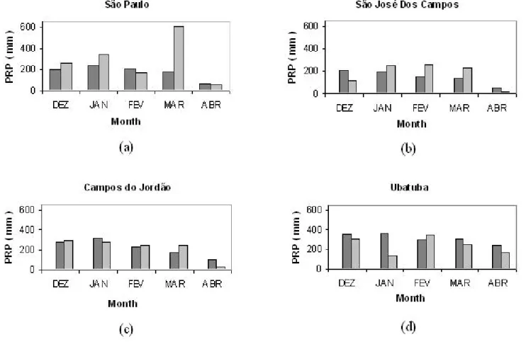
Figure 3 shows monthly rainfalls in December 2005 through March 2006, as compared to the monthly normals, at the four stations, São Paulo, São José dos Campos, Campos do Jordão and Ubatuba. The rainfall in March 2006 at the São Paulo station exceeded 600 mm while the normal for the month of March is less than 200 mm. The March rainfall was almost equal to the total Dec-Jan-Feb seasonal rainfall. At the São José dos Campos and Campos do Jordão stations the rainfall in March exceeded signiicantly the respective normals for that month. At Ubatuba station the March rainfall was slightly less than the normal, but nonetheless it was more than 200 mm. The climatological value of the number of rainy days with rainfall > 5 mm/day in March in São José dos Campos, based on the data collected at the airport for 1974-2006, is 8 (Calbete 2007, personal communication). In March 2006, however, the number of such rainy days was 11. From these data we conclude that March 2006 was a more-than-normal rainy month in the eastern parts of the state of São Paulo.
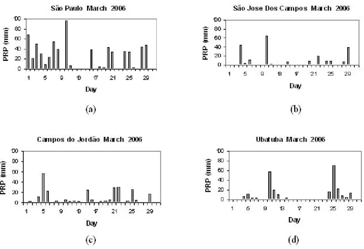
The daily distributions of rainfall in March for the four stations are shown in Figure 4. It is clear from the igure that the rainfall was not uniform over the month. In São Paulo, the irst 1/3 of the month was very rainy and the middle 1/3 was less rainy. The other three stations also show rainy and nonrainy
Figure 5 – Daily distribution of mean precipitation (mm) over eastern São Paulo state for March 2006.
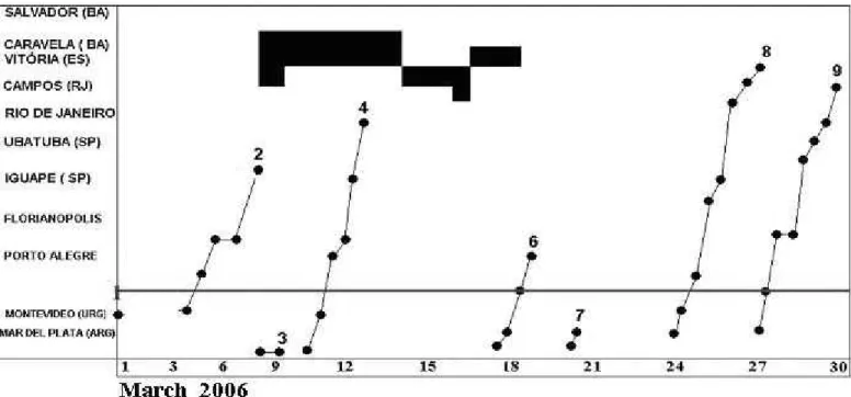
Figure 6 – Frontal system incursions along the east coast of South America during March 2006. The horizontal line north of Montevideo demarks the border between Uruguay and Brazil. The dark areas indicate the position of the SACZ.
episodes during the month. The episodic characteristic is clear from the rainfall distribution at the Ubatuba and Campos do Jordão stations. We can see that at Campos do Jordão the periods 04-06 and 20-22 recorded more than 70 mm in 3 days, whereas the periods 11-14, 17-19 and 26-28 received less than 8 mm in 3 or 4 days.
Figure 5 presents the four-station average daily rainfall, from which we can see that the 5-day periods (pentads) 6-10 and 25-29 received nearly 100 mm. The 5-day periods 12-16 and 17-21 received less than 10 mm. The two distinct pentads 06-10 and 12-16 are chosen to characterize, respectively, a rainy episode and a nonrainy episode. Thus, these two pentads are used to study the differences in the regional atmospheric circulation characteristics. The difference patterns may constitute a conceptual model for heavy rainfall situations in the region. Thus, during the transition month, the meteorologist is encouraged to look for patterns similar to the ones obtained here in the outputs of medium-range numerical forecast models in his or her operational routine.
4. MONTHLY MEAN CIRCULATION CHARACTERISTICS
The frontal activity over the eastern parts of South America during March 2006 is shown in Figure 6. Three
systems reached Ubatuba during the month. The SACZ was active in the state of Espírito Santo during the period 7-18. Both the rainy episode of 06-10 and the nonrainy episode of 12-16 occurred during active SACZ periods. This indicates that the formation of SACZ is not a suficient condition for the occurrence of heavy rainfall in eastern southeastern region of Brazil. This makes the study of the differences between the rainy episode and the nonrainy episode more interesting.
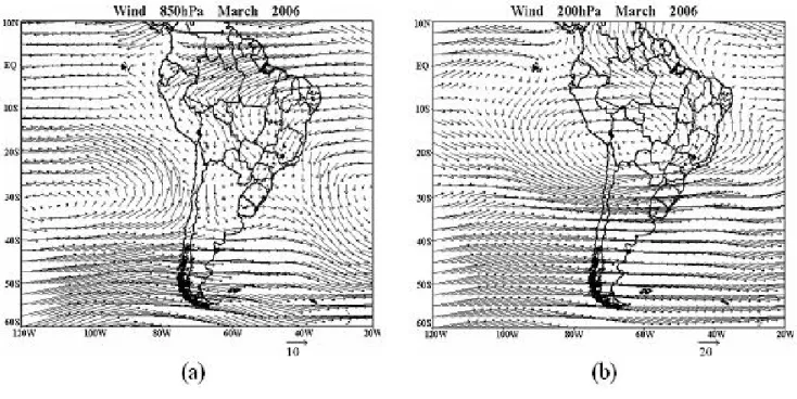
The monthly mean charts of 850-hPa and 200-hPa wind ields for March 2006 are shown in Figure 7. The lower tropospheric winds (Fig. 7a) were strong east-northeasterlies in the equatorial South America. In the region between 10ºS-30ºS the winds had a strong northerly component, with stronger northwesterlies over northern Bolivia and central-western Brazil and with northeasterlies over Bahia and Minas Gerais states. These winds formed a conluence region over Goias, Minas Gerais and São Paulo states. It is important to note that the low-level jet over Bolivia in this month, with its NW-SE orientation, did not penetrate into Argentina. Thus the transport of latent heat from Amazon region was more directed into Southeast Brazil. The winds in the upper troposphere (Fig. 7b) show a huge anticyclone over the zonal belt of 5ºS-30ºS. This is the Bolivian high with elongated zonal dimension from 100º W to 25º W. The westerly jet to its south is situated over northern Argentina, Uruguay and the state of Rio Grande do Sul. The
upper level anticyclone is an indication of a warm troposphere. The upper air trough down stream of the Bolivian high is away from the continent in the Atlantic near 20ºW. This is perhaps a favorable condition for the SACZ formation north of 20ºS, since SACZ region is known to present a ridge in the upper troposphere (Figueroa 1999).
5. RAINY AND NONRAINY EPISODES
Here we draw comparisons and contrasts between the composites for rainy and nonrainy episodes of, respectively, 06-10 and 12-16 March 2006, to be able to appreciate why the episodes behaved distinctly. To achieve this we present irst the atmospheric variables for the two episodes side by side.
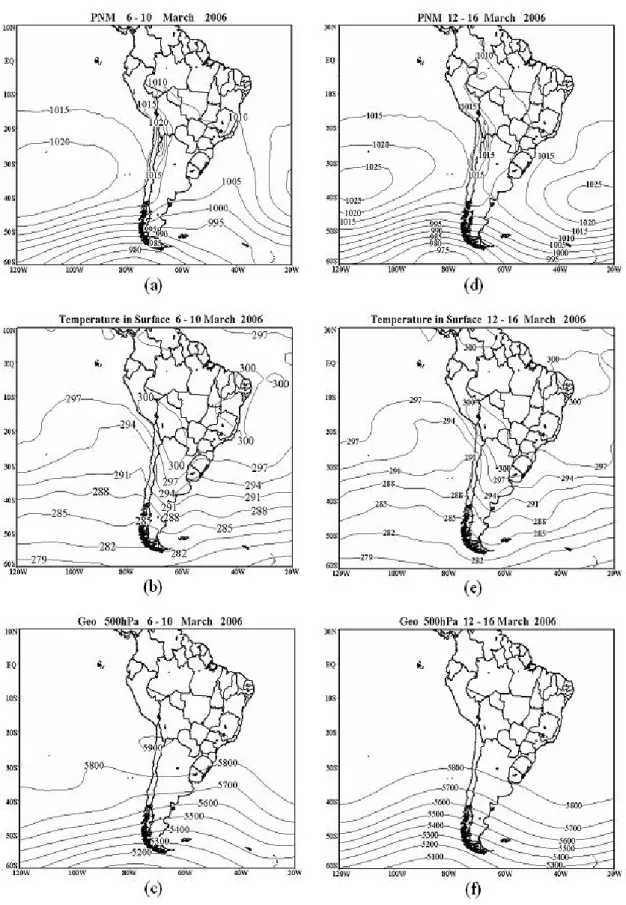
Figure 8 shows the composite ps, Ts and f500 ields
for the two episodes. The surface pressure ields for the two episodes almost look alike and normally large differences are not
expected. However, there are some differences. The subtropical highs in the Paciic and the Atlantic are farther from the continent and there is a fairly strong S-N oriented short-wave trough off the Uruguay coast during the rainy episode. In the case of the nonrainy episode the trough in the Atlantic is very weak and is perhaps associated with the monthly mean SACZ north of São Paulo. The mean high pressure values in the subtropical highs (1020 hPa) (Fig. 8a) during the rainy episode is weaker than during the nonrainy episode (1025 hPa) (Fig. 8d).
The surface temperature patterns (Fig. 8b,e) are quite similar in the two cases, especially because the horizontal temperature variability in the tropics is small. In both cases the continent is warmer than the surrounding oceans, consistent with the upper air anticyclonic circulation. However, a cool air tongue is seen over Rio Grande do Sul state and Uruguay in the rainy case and the tongue is found over the coastal waters in the nonrainy episode. These details cannot be taken too seriously
because of the inherent errors and the coarse resolution of the NCEP data for this purpose. Signiicant differences are not observed in the speciic humidity composites also (not shown). The relative humidity composites (also not shown) essentially present the same characteristics in both the episodes, with 90% humidity over Minas Gerais state and eastern parts of São Paulo state. These observations indicate that the upper air low characteristics are perhaps more important to determine if an episode is rainy or not. The whole idea is to caution the meteorologist that searching for signiicant differences between rainy and nonrainy episodes in the T, ps and RH ields is not very productive. Instead, it is more beneicial to examine the upper
air low characteristics to forecast prolonged heavy rainfall periods in eastern São Paulo.
The 500-hPa geopotential ield (Fig. 8c,f) shows some signiicant differences. The nonrainy episode shows a trough near the Chile coast and a ridge in the Atlantic, forming a long wave. The rainy episode shows two short wave troughs, one at 100ºW and the other at 45ºW in the latitude belt 30ºS-50ºS. The trough in the Atlantic, along with the trough at the surface slightly to the east, seems to be important for the convective activity responsible for the rains during this episode.
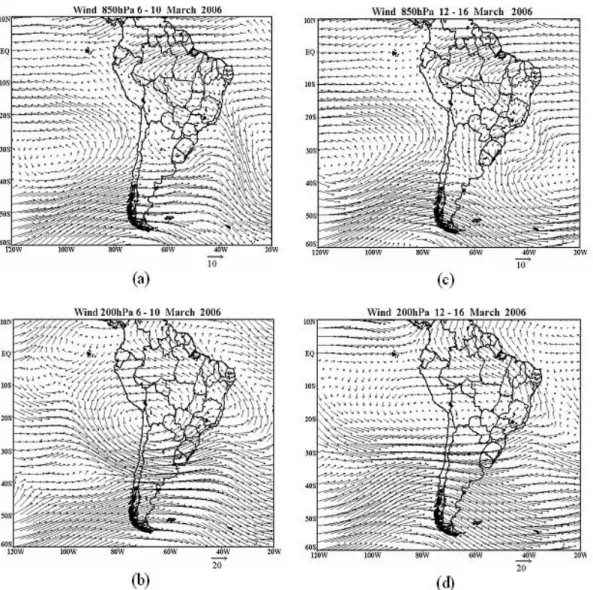
The motion field in the trough region provide the dynamical synoptic-scale forcing necessary for upward motion
through advection of absolute vorticity by thermal wind. We can see the wind ield composites at 850-hPa and 200-hPa for the two episodes in Figure 9. The thermal wind (the difference between the 200 hPa and 850 hPa levels) is southerly and the advection is cyclonic in the rainy case. This effect is weak in the nonrainy case composites.
The lower tropospheric winds in the two cases show some regional differences. A cyclonic center in the Atlantic, associated with the trough at the sea level discussed above, is situated off Uruguay coast and the strong northwesterly winds are situated over Bolivia and Mato Grosso and Mato Grosso do Sul states in the rainy case (Fig. 9a). In the nonrainy case (Fig. 9c) the winds are stronger over Mato Grosso state with an indication of conluence and convergence in the western Minas Gerais state with the northeasterlies over Minas Gerais. At the 200-hPa there are some noticeable differences between the two episodes. During the rainy episode the Bolivian high is stronger and the jet core is oriented SW-NE over southern Brazil (Fig. 9b). This indicates that the troposphere in the tropics of South America is warmer during the rainy episode.
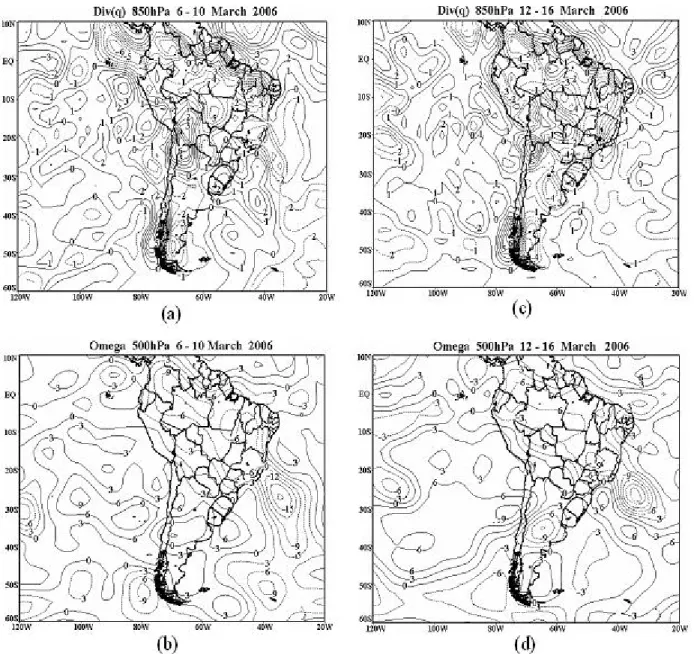
Figure 10 shows the composites of moisture flux convergence at 850 hPa and vertical velocity ield at 500 hPa for the two contrasting episodes. Over the eastern parts of São Paulo state there is convergence of the order of 2x10⁻⁵
g kg-1 day-1 during the rainy episode (Fig. 10a) while there is divergence of the same order during the nonrainy episode (Fig. 10c). The vertical velocity is -3 Pa s-1 (rising motion) over eastern São Paulo during the rainy episode (Fig. 10b) and it is near zero during the nonrainy episode (Figs. 10d), in agreement with the rising motion inferred above. That is, the lower-tropospheric moisture convergence and the midtropospheric large-scale rising motion show favorable conditions for the rainfall to occur in the rainy episode.
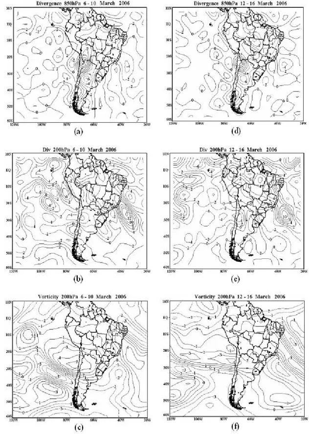
Figure 11 presents the mass divergence composites for 850 hPa and 200 hPa and the relative vorticity composites for 200-hPa level for the two contrasting episodes. During the rainy episode the convergence in the lower troposphere over eastern São Paulo is of the order of 2x10⁻⁵ s-1 (Fig. 11a) while during
the nonrainy episode it is zero convergence or divergence of the same order (Fig. 11d). This suggests that the mass convergence in the lower levels is a major contributor for the moisture convergence and midtropospheric upward motion necessary for convective activity. The moisture convergence has two terms: s.(qV) = qs.V + V.sq. As the humidity is uniform, the second term does not contribute much in the tropics and perhaps subtropics. So the irst term is the major contributor. The mass divergence at 200 hPa shown in Figures 11 b and e does not show signiicant differences between the two episodes over eastern São Paulo. The relative vorticity composite ields at 200 hPa are presented in Figures 11 c and f. The elongated region of
strong upper tropospheric anticyclonic vorticty is a characteristic of active SACZ. Such a region is observed over Bahia in both the cases. During the nonrainy episode the cyclonic vorticity area is elongated southeastward in the Atlantic, indicating a moving cyclone. However, during the rainy episode a cyclonic vorticity center is observed off the Rio Grande do Sul coast, indicating that a cyclonic system persisted there for the 5-day period (Fig. 11c). It is important to recognize that the transient perturbation near the southern coast of Brazil was stationary or moved slowly during the rainy episode.
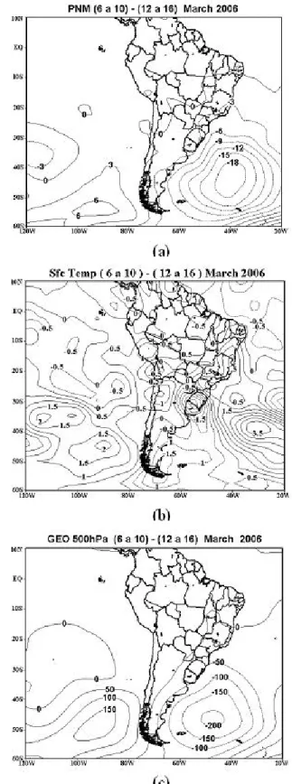
The differences between the composites of the two episodes are shown in Figures 12 and 13. The surface pressure differences (Fig. 12a) show a low-pressure center in the Atlantic off Argentina coast with a trough of –3 hPa over the eastern parts of São Paulo state. That is, as expected the surface pressure during the rainy episode is 3 hPa lower than during the nonrainy episode over the region. The differences in near surface temperature (Fig. 12b) show a cool air pool over southern Brazil and a warm air pool over eastern São Paulo showing that there is frontal effect also during the rainy episode, with rising warm air over eastern São Paulo. The geopotential difference (Fig. 12c) shows almost the same pattern as the surface pressure difference, except that the center of the low pressure area at 500 hPa is slightly inclined to the west of the surface low pressure area, showing that the synoptic situation is more baroclinic during the rainy episode than during the nonrainy episode, which is necessary for the maintenance of the system for periods of four days or longer. More moisture convergence and stronger upward motion can be veriied over eastern São Paulo state during the rainy episode from Figure 13.
Figure 13 – Differences between rainy and nonrainy episodes. (a) Humidity lux divergence (10-6 s-1), (b) vertical motion (Pa/s). Broken lines
indicate negative values.
6. SUMMARY AND CONCLUDING REMARKS
Larger than normal rainfall in March 2006 in the eastern parts of the state of São Paulo caused many problems for the population of that region. The rainfall was episodic, i. e., there were periods of three or more days of rainfall interspersed by periods of very little or no rainfall. The question that arises is what special characteristics make a rainy episode. We have presented, in this study, comparisons and contrasts between the composite atmospheric variable ields for a rainy episode (06-10) and a nonrainy episode (12-16) during March 2006.
subsiding motion and the divergence of moisture lux during the nonrainy episode. In the upper troposphere the Bolivian high was more intense, indicating that the troposphere over tropical SA was warmer, during the rainy episode. Southeast of the Bolivian High the winds were strong southwesterlies over southern Brazil. During the nonrainy episode the anticyclonic circulation was weaker and is more zonally elongated with westerly winds over the southern parts of Brazil. In terms of the 200-hPa relative vorticity, rainy episode showed a more stationary cyclone near the Rio Grande do Sul coast while the nonrainy episode showed a southeastward moving cyclone. The advection of cyclonic vorticity over eastern São Paulo by the thermal wind caused large-scale rising motion, which was necessary for the formation of convection.
These contrasts between the two episodes can assist the meteorologists to distinguish a prolonged rainy episode from a prolonged nonrainy episode during post-summer period over eastern São Paulo. The composite ields are the means of 5 days and therefore the differences between the two episodes are not due to high frequency variability (less than 48 hours). This medium-range variability is part of intraseasonal variability, whose characteristics should be understood for improving the medium-range or intermediate-range weather prediction. The results also suggest that the synoptic features in the pressure, geopotential and wind ields can serve as indicators of a rainy episode.
7. ACKNOWLEDGEMENTS
The first author is “Amazonas Senior” scholor of FAPEAM (Amazonas State Foundation for Research) at the National Institute for Amazon Region Research (INPA) since July 2007. The authors are grateful to Antonio Ocimar Manzi, Head of LBA Program, for his encouragement.
8. REFERENCES
CALBETE, N. O. Characteristics of São José dos Campos rainfall. Personal Communication, 2007.
CLIMANÁLISE Centro de Previsão de Tempo e Estudos Climáticos (CPTEC), Instituto Nacional de Pesquisas Espaciais (INPE), Cachoeira Paulista, SP, Brazil, 2006. FIGUEROA, S. N. Estudo dos sistemas de circulação de verão
sobre a América do Sul e sua simulação com modelos numéricos. Doctoral Thesis, Instituto Nacional de Pesquisas Espaciais, São José dos Campos, SP, pp. 250, 1999. KALNAY, E. et al. The NCEP/NCAR 40-Year Reanalysis
Project. Bul. Amer. Met. Soc., v. 77 (3), pp. 437–471, 1996. RAO, V. B.; HADA, K. Characteristics of rainfall over Brazil:
Annual variations and connections with the Southern Oscillation. Theor. Appl. Climatology, v. 42 (2), pp. 81-91, 1990.
SATYAMURTY, P.; NOBRE, C. A.; SILVA DIAS, P. L. Tropics: South America. In: Meteorology of the Southern Hemisphere, eds. David J. Karoly and Dayton G. Vincent, American Meteorological Society, Boston. 119-139, 1998. TEIXEIRA, M. S.; SATYAMURTY, P. Dynamical and Synoptic