Escola de Tecnologias e Arquitetura
Departamento de Arquitetura e Urbanismo
Mestrado Integrado em Arquitetura
Nome aluno
Alaa Al Hariri
Architecture as Frontline: Between an Art of
Cohesion and a Weapon of Oppression
Orientador da vertente teórica:
Doutora Eliana Sousa Santos, ISCTE-IUL
New Entrance of Alenquer
Tutor da vertente prática:
Doutor Pedro Pinto, ISCTE-IUL
ii
General Table of Contents
• Theoric part :
Acknowledgement ... IV
Abstract ... x
Table of contents ... xiv
1.Introduction ... 16
2. Syria ... 26
2.1. Damascus... 32
2.2. The War Impact ... 53
3. Conceptual Frames: ... 57
3.1. Space ... 58
3.2. Memory ... 60
3.3. Urbicide ... 62
4. .Law Number 1 ... 66
5. Case of study(Beirut) ... 73
6. Sample area(Eastern Ghouta - Douma) ... 107
7. Conclusion and recommendation ... 121
List of Biography ... 134
List of Figures ... 142
IV
ACKNOWLEDGEMENT
The path toward this work was harsh, full of challenges, and completeng it was a continued effort. It wasn’t only writing , it was a sharing of memory and soul.
I would like to sincerely thank my supervisor Professor Eliana Sousa Santos, because I was lucky to have her guidelines and she was courageous enough to take this mission with me, as well as to my project professor Pedro Pinto for his
continued support.
Similar, I owe a debt of profound gratitude to the Global Platform for Syrian Students and especially for the former president of Portugal Mr. Jorge Sampaio along with Dr. Helena Barroco for their kindness and support, and to whom I
owe the opportunity to achieve my studies and step forward with my academic progress.
For my amazing Portuguese family, Soromanho and Henriques especially for my host Teresa Soromanho who has been the most influential person on my life in the last three years.
Also, I would like to extend my thanks to my friends and colleagues at the architecture faculty, my amazing friend Naheed, and Rasha , Rita , Ahmad and Eiad, who supported me in Portugal, and Reem and Nour abroad. For the
people who had been and will always be a part of my memory and a constant motivation Miss Sima, Rebal and Ibrahem. And to those who rest in peace Salah, Mazhar, Deema.
And for all the members of my family: my parents and my brother Mouhanad and Lami. And especially to my mother who supported me throughout my academic year and my life in general.To you all, I dedicate this work! To all the
vi
Alaa Al Hariri
Architecture as Frontline: Between an Art of Cohesion and a Weapon of
Oppression
Orientador da vertente teórica:
Doutora Eliana Sousa Santos, ISCTE-IUL
viii
Resumo
Ao longo das últimas quatro décadas, a região do Levante tem sido o palco constante de guerras que causaram danos humanos e destruição física das cidades e das suas infraestruturas. A violência extrema que tem atingido o território resulta na destruição do tecido socio-urbano, não apenas durante os conflitos, como também nos períodos de reconstrução, uma vez que afecta profundamente a memória colectiva e provoca um enorme impacto na herança tangível e intangível das populações atingidas.
Há oito anos que um conflito devastador tem assolado a Síria, onde as cidades se transformaram em campos de batalha. A estrutura social e psicológica foi destruída, um terço das casas foram atingidas e mais de 12 milhões de pessoas tiveram de abandonar as suas casas, partindo para outras zonas mais seguras ou saindo do país.
Esta disertacao apresenta uma perspectiva detalhada da cidade de Damasco e das mudanças sociais e urbanas que culminaram no conflito actual. Também aborda algumas das possíveis marcas que a guerra deixará no futuro, tendo em conta a nova Lei 10, que foi a resposta encontrada pelo Governo para a reconstrução das áreas destruídas.
A investigação examina ainda os conceitos de urbicídio, espaço e memória, relaçãoionaudo se depuiudo e a maneira adequada para lidar com as linhas sectárias e as memórias de guerra. A disertacao apreresente Beirute como um caso de estudo, analisando a história urbana antes da guerra civil e o período de reconstrução.
ix
Em conclusão, esta dissertação apresenta propostas para a região de Ghouta Oriental, no distrito de Damasco, cuja principal cidade, Douma, foi palco de uma das batalhas mais importantes do conflito sírio. Esta área foi escolhida como um exemplo de como se poderá pôr em prática uma estratégia de unificação da sociedade, ligando a cidade aos seus subúrbios através de um trabalho conceptual.
x
Abstract
During the past four decades, the Levant area has been a constant host for several wars that caused huge damages on the social level and physical destruction for cities and its infrastructures. This extreme violence in cities has been taken as a tool to destroy also the bonds of socio-urban fabric during the wars, and in the periods of reconstruction, which caused damages in our collective memory as well as dramatic impact in our tangible and intangible heritage.
Syria has been suffering from a devastating conflict in which cities became battlegrounds for different wars for eight years and continuing. So far it caused destruction in the physical and social structure and displacement for over twelve million people internally and in other countries in addition to damages to nearly third of the Syrian houses.
This dissertation presents a detailed overview of the city of Damascus, its urban and social changes over time leading to the on-going conflict. It also covers the possible impacts in the future by considering the new Law 10 which wasthe government response to rebuild the destroyed areas as new politic of reconstruction the destructive areas. This research examines the concepts of urbicide, space and memory, in order to define their relation and the best way to deal with division line and war memory. In addition, the research takes Beirut as a case study, by studying the urban history of the city before the civil war and the period of the reconstruction.
xi
As conclusion the dissertation presents proposals for Eastern Ghouta in Damascus, which witnessed one of the important battles in the Syrian conflict with it main city Douma. This area has been selected as a sample area to propose a vision of uniting the society through a strategy that links the city with its suburbs by a conceptual work.
xii
Figure1:The art of oppressionxiv
Table of Contents
• Theoric part :
Acknowledgement ... IV
Abstract ... x
Table of contents ... xiv
1.Introduction ... 16
2. Syria ... 26
2.1. Damascus... 32
2.2. The War Impact ... 53
3. Conceptual Frames: ... 57
3.1. Space ... 58
3.2. Memory ... 60
3.3. Urbicide ... 62
4. .Law Number 1 ... 66
5. Case of study(Beirut) ... 73
6. Sample area(Eastern Ghouta - Douma) ... 107
7. Conclusion and recommendation ... 121
List of Biography ... 134
16
17
Research Objectives
The main aim of this research is to make a clear guideline to understand some of the sides of the postwar reconstruction in the Middle East, by studying the former political and urban aspects of the case studies —Damascus, Beirut — before, during and in the case of Beirut, after the war.
Also, defining a correct approach to understand the successes, failures and errors of the applied methodologies in post conflict situations considering the case of downtown Beirut, and define its impact on the social fabric of the city and how it contributes to the trauma of the society in a way that it dealt with memory of war and division line.
In addition, the research will discuss the new law No.10 of reconstruction in Syria with the new approaches of reconstruction and its effects on the Syrian society, as well will propose a conceptual framework to deal with Ghouta according to the concepts memory, urbicide ,space and applied it on the city of Douma.
Research Questions
The study addresses the following questions:
How urban reconstruction strategy helps or not in healing societies after civil war?
18
What are the lessons learnt from post-war reconstruction methods applied in case of Down Town Beirut?
Research method
This study is based on analyzing the urban and the political history of the study cases before, during and after the war and the reconstruction strategies and it impacts on the Lebanese society in the case of Beirut and the possible reconstruction methods in Damascus and its suburbs considering memory of the war and the way to deal with it and the space in the destroyed cities.
State of the Art
The debate around the political framing of the built environment has been very active since the last century and continues until nowadays. “Is space political?” this question was asked by Fredric Jameson— the American literature and cultural theorist, and one of the key theorists of postmodernism. Jameson who usually address the questions of cultural theory, argued that the political ‘content’ in architecture appears evident, either in building codes, zoning, city ordinances or local politics (Leach 1997,242)
Henri Lefebvre the French philosopher and sociologist argued in his book The Urban Revolution (1970) “That since everybody is involved in the built environment— architects, developers, planners,
19
politicians, and even citizens—space is never neutral, and it is profoundly political.” It depends on the spatial practices of whatever cultural dominant is producing. For Lefebvre, the results of spatial production are indelibly marked with the ideologies—economic, social, political and cultural—of the commissioning authorities that make buildings and cities possible.” (Coleman 2015,759)
We can see the proof of changes in spaces and the character of the space’s production through our daily life in our environment, especially in cities.
We observe how our cities have been transformed throughout history, especially after wars in reconstruction, according to the ideological, economic and social circumstances of the power that dominate the territory.
Because war is the biggest urban changer and destroyer, urban reconstruction after wars have different ways and methods of dealing with incidents of the war itself and the memory of it. In recent history, Europe has had its own experiences of urban reconstruction, namely after World War II the emergence of different architecture and urban movements in response to its consequences.
20
In the Middle East, especially in the Levant area, the question of the built-up environment and the identity of the spaces has been repeatedly focused on since the late 1980s.
Specially with the consequences of different wars in the region, cities like Beirut, Damascus and Aleppo have been suffering from the intractable huge spatial destruction in the city and spatial violence, which led many of those ancient cities to suffer the ‘urbicide’ of civil wars.
Many scholars have been considering civil war reconstruction in the Middle East Countries such as in Beirut. Namely Jad Thabet — The head of the Syndicate of the Architects in Lebanon (2018) — in his book Architecture and public benefit In heritage and
modernism: Beirut a city of war and a memory of the future (1996)
he included several articles and conferences that took place between 1983 and 1995 in Beirut and internationally, related to the reconstruction discussions and the memory of the city during the war during the Israeli invasion, the urban history of the city and a clear criticism to the reconstruction projects, namely the Solidere project.
Moreover, Mona Fawaz and Marwan Ghandour in their joint article “Spatial Erasure: Reconstruction Projects in Beirut” (2010) discussed the reconstruction strategies in Beirut after the two wars — the Civil War (1975 -1990) and the Israeli-Lebanese War (2006).
21
They explain how the city maintained the consolidation barriers of society referring to downtown Beirut reconstruction and Wa‛d project in Haret Hreik, Beirut.
Other scholars like Joe Nasr in his publication The Reconstructions
of Beirut (Nasr et al., 2008) observed the historical urban
development of the city canter of Beirut, during the colonial era — Ottoman and French periods — and how the new intervention plans after the Civil War in the city center of Beirut, namely the Solidere project, where pushing the city out of its character and towards a model that doesn’t correspond to its original identity and turning downtown to an isolated part of the city.
In Syria, due to the current war, the question of the reconstruction of cities is fundamental. As is the reflection about the types of built environment, strategies of reconstruction and the way of dealing with memory of war. These issues have been very controversial even before the violence even ended. According to Steve Heydeman “the debate about post-war reconstruction is emerging even though the war didn't end yet”(Carnegie, 2018).
Many movements and conferences have been taking places like,
Rebuilding Syria (University of Venice, July 2017) which had a
publication of The Making of the Future: From Urbicide to the Architecture of the City a publication for the workshop conferences
22
and conclusion in addition to the result of the cities workshops. Another event was Rebuilding Syria from within (University of Minho, July 2018) and real rehabilitation projects have been funded like the project of the UNDP in cooperation with Homs govern to rehabilitate Homs’ old markets.
Besides these events, an online platform has been founded Syrbanism which is a participatory platform that focuses on investigating the political, social and economic aspects of the urban discourses in Syria.
Scholars like Marwa Al-Sabouni — the first winner of the UN-Habitat Competition for rehabilitation of mass housing for rebuilding Baba Amr — discussed in her book, The Battle for Homs:
The Vision of a Young Architect in Syria (2017), the urban character
of the city Homs before the war, and how the urban strategy contributed to divisions within the society, and how that contributed to the war, taking Bab-Amr neighbourhood as a case study and critiqued the urban proposal that recently created for that zone of the city .
As well, Nahed Nabhan in her dissertation “Urbicide perception and reconstruction strategy strategies in post-war socio urban tessiture. The case of Jobar, Damascus” discussed how to deal with memory and trauma of war in the city of Jobar in rural Damascus. Nabhan proposed a way to deal with underground tunnels that
23
were constructed during the war to break the siege around the city, as a way to preserve the memory of the war but by using the tunnels as passages in the future of rebuilding.
All these references served as a guide to the work developed in this dissertation.
26
27
Dear lord ……please return me to the desert…. Erase the borders that have boxed me in and defaces the horizon in the memory28
Brief on Syria
Syria with its boundaries nowadays exists on the eastern cost of the Mediterranean, it is a recent country administratively, the borders were defined by the Sykes-Picot agreement1 in 1916
(figure 2) — before it was a part of the Ottoman Empire.
In 1946, Syria achieved its independence from the French occupation and maintained the same borders until nowadays. Syria had a population of 22 087 048 in 2011 and was considered a hastily growing country “the population grew from 8 million in 1972 to 22 million in 2011” (Eissa 2015, 23).
Syria was affected by different wars in the region which caused the population to have different refugee’s communities — Armenian,
1.The Sykes-Picot Agreement was a secret contract devised by the British and French governments during World War I. While the Allies fought against the Ottomans, the British encouraged the Arabs, who had been part of the Turkish Empire for over 400 years, to revolt and fight for Arab independence, thus weakening the enemy. The British promised an independent Arab State to the Emir of Mecca, Sharif Hussein Bin Ali. However, at the close of the Great War, the victors reneged on their promises, and the ‘Arab’ world was divided up between the British and the French according to their secret plans. This disloyalty is still fresh in many Arabs’ minds, and underlies a strong distrust of the West and its intentions. (Farsoun 2002, Lababedi 2008, Nabhan 2017).
29
Iraq, Palestinians. As well, the country is well-known for having a great mix of religions and ethnic groups.
In 2011, Syria has witnessed an uprising all over the country, asking for freedom and liberty of speech, the demonstrations were faced with harsh military operations which led to formulation of arming groups funded by different countries around the world, and led the country to be in a violent civil war until today.
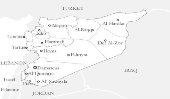
The following chapter will follow the urban history of Damascus, the capital of Syria. A city that has suffered the consequences of war, but it hasn’t witnessed a destruction in the central historical core like other cities, such as Homs or Aleppo. Instead, it had a destruction in the rural area like Ghouta and some surrounded neighbourhood such as the city of Jobar,and Qaboun.
30
Figure 2: Syria and the borders of Sykes-pico (author work).31
Figure 3:Syria and its surroundings (author work).32
2.1. Damascus
InDamascus
I count my ribs and return my heart to its amble
Perhaps the one that admitted me to her shadow killed me And I did not notice
(
Mahmoud Darwish)33
Figure 4:Damascus mountain view. Image by: Shutterstock/longtail plume 2004.34
❖ Damascus
Damascus is the capital of Syria and one of the oldest continuously inhabited city in the world. Geographically, it is crossed by Barada river, and boarded by Qasioun mountain. It is located in south west of Syria, it was a hometown for almost five million inhabitants in 2011, and the Arab Capital of Culture 2008 and UNESCO world heritage site since 1979.
Damascus has oone of the world’s highest urban growth rates, and different suburbs which became part of the city because of the fast-urban growing. Urban History of Damascus
Damascus was known for its beauty and the wonderful eastern and western Ghouta of which has the evidence of habitation in Damascus back to 5000 BCE. “The city has been always developed to chief trading stops according to the ancient Acadian and Egyptian documents: three major roads led out of the city; the western road led towards Egypt, the southern road led to Mecca, and the eastern road led to Babylon” (Lapidus 1973 cited by Lababedi 2008,15).
Damascus has been always developed according to different civilizations like the Roman and Greek and Othman …etc, that left their trace on the urban fabric; streets, alleys, monuments, homes, and people along their traditions and ways of living and language.
35
❖ Hellenic era
A lot of researchers see in Damascus and other middle eastern cities only the character of the Islamic cities ,those analyses overlooked the early formation of the Roman and Hellenistic cities (336-146 BC), even though the elements of those civilization define the structural core of the city nowadays and we can see how many of those elements survived and even continue to be in many cases the current road plans.
During the Hellenic era, the creation of the metropolitan was concentrated of creating a place of worship and commercial, in the city center, and we see the same routes exist until nowadays — for example the site of the Greek temple is today the site of the Omayyad Mosque (figure 6).
❖ Roman era
Damascus in the Roman era (64BC) was approximately the same size as the old walled city of today. As Lababedi mentioned “From Bab Sharqi (Figure 7) to Bab al-Jabiya. Two of the seven gates of the Roman city” (Lababedi 2008, 17). As well the Romans applied changes on the Jupiter Temple and the Agora (Figure 8) and extend the straight grid.
36
Figure 5:The Greek Temple of Jupiter and Damascus street map. Image by: Burns (2005), available at: Lababedi, Z. (2008.)Figure 6:The Greek city located within today’s Damascus old city walls. image by: Burns (2005), available at: Lababedi, Z. (2008).
37
❖ Byzantine
The city went into Byzantine hands in 600AD, during this period there was lacking in administrative organization, which led the church and house owners to have the freedom to expand their properties, and the temple of Jupiter was rebuilt as the Cathedral of St. John the Baptist (Eissa 2015, 25).
❖ Islamic Era
Damascus was taken easily by the Islamic armies (635 AD), with the introduction of Islam, the unregulated expanding of houses and mosques continued.
“As Lapidus (1973) describes, contrary to many ideas of ‘Islamic urbanism’, the early Umayyad city was not one of grand designs and developments. New cities were rarely built, with new settlers, the Arab garrisons typically settling into the existing quarters of the conquered cities.” (Lababedi 2008,18)
The urban life and economic activity continued the same sites as it used to be, open spaces disappeared and many of the straight Roman streets grid with large open spaces turned into “Islamic” narrow street-cities happened slowly taking many centuries to form and because of the strong ritualized living patterns. During that era the Omayyad Mosque was built on the same site as Cathedral of St. john the Baptist.
38
Figure 7: Bab Sharqi.Figure 8:The Roman city of Damascus,(author work) based on Burns (2005).
39
In 750 AD, The Abbasids got the control over the Omayyad’s and made Bagdad their capital, according to that Damascus had a declining population and a lot of Omayyad buildings had been destroyed which causes an erasing for large parts of the city.
In 1154 AD, during the Ayyubids, the first comprehensive ‘town-planning’ of Damascus, Satellite suburbs as Salihiye, Maydan, and Saruja develop on roads leading out of the city which caused the city to flourish.
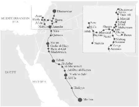
Under the Ottoman’s empire, Damascus grew along the route to Mecca2 (figure
9) and developed the straight street suburbs in late 20th century.
The Hajj-migration added over 30 % of the population. Damascus grew south along the route to Mecca and the old area of Maydan which according to Lababedi “became fully incorporated into the city as a residential suburb” (Lababedi 2008, 23) Settlements also grew following the road up to Saliheye (figure 10).
2 Mecca which is the holly place for the Muslim religion, located in
Saudi Arabia nowadays, Alhaj which is a mandatory religious duty for Muslims that must be carried out at least once in their lifetime by all adult Muslims who are physically and financially capable of
40
Figure 9:Route to Mecca, ( author work).41
Figure 10:Development of neighbourhood through different periods, Al-Qattan (2002).42
There were different periods for the Ottoman intervention in Damascus, but the most noticed ones were in the last sixty years of the Ottoman’s era, new urban changes introduced to the city (Tanzimat3), by the Sultan order
influenced by Europe modernity, three main principles for Damascus: 1. “Widening of streets and roads
2. The design of new suburbs with geometric patterns. 3. Construct in stone instead of wood”. (Lababedi 2008,28)
That made an influence on the urban fabric of the city which applied changes because of several developments like trains stations, electric tramways, streets lights, cafes, theatres. The city became less dense as a result of new residential areas that included wide streets and numerous gardens and public parks, those changes as well led to a change in the social fabric of the city.
3 Tanzimat was a movement in the late 1800 in the Ottoman’s empire
included a lot of modernization plans and social movement in the all Othman’s territory, and developed a new urban trend subordinated to three principles fully attributed to western influences: widening of streets and removing dead ends, designing new suburbs with geometric rules, constructing with stone instead of wood (Traboulsi 2013,47).
43
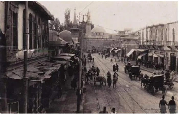
Figure 11:Damascus,1870. . Image by: Dimashq in black & white.Figure 12:Damascus, Darwishih quarter 1920, . Image by: Dimashq in black & white.
44
Figure 13::Souk AlHamadih .1918, . Image by: Dimashq in black & white.Figure 14:Saliheye in the Othman time, . Image by: Dimashq in black & white.
45
❖ Post World-War I Damascus – The French Mandate
(1920-1946)
By 1925, the Great Syrian Revolt the French troops shelled the old quarter of the city during an uprising which caused several damages After that, the French understood that they needed to change the strategy by “creating new spaces and using urban planning to create new settlements in a way that – they thought – would reshape the Syrian people to be more docile, more easily governed” (Rollins 2018).
In 1935, the first master plan for Damascus “Danger and Ecochard” presented a new road system, creating a ring road around the old town, to ease congestion and to display the cultural heritage of the old city.
They also proposed a new sewage system for the city including the old town. However, the French Mandate and Independence planning mainly focused on building new modern housing outside of the old city.
The focus was on separating the Old city and the modern European city, Later, the new suburbs were designed with tree-lined streets, like Abu Rummaneh area (Figure 15) and Bagdad Street.
46
Figure 15:Abu Rummaneh neighbourhood, . Image by: Dimashq in black & white.Figure 16:Alhijaz , Orient palace, . Image by: Dimashq in black & white.
47
❖ Ba’ath and Contemporary Damascus
Syria achieved its independence in 1946, later the country went through periods of political instability and internal struggles.
In 1958, Syria united with Egypt forming one republic named United Arab Republic (UAR), under the rule of Jamal Abdul Naser and the banner of socialism. Some of the laws caused problematic issues regarding the agricultural land and ownership of lands for Syria after two years from UAR, Syria withdrew from that union.4
In 1968, Michel Écochard, the French architect, was invited to participate again in setting new plans for the city and expanding it and producing “Damascus that would be grounded in the principles of 'functional' town planning from the Athens Charter” (Abdulac 1982).
Écochard’s aims, according to Abdulac, “tied together elements of history, regional planning, hydrology, demography, studies of traffic, the provision of amenities and concentrated on protecting the water sources of Damascus (la Ghouta)” (Abdulac 1982).
4 According to Nabhan: “Agrarian Reform Law No 161; each individual
was allowed to own maximum 80 hectares of irrigated land or 300 hectares of rain fed land. In order redistribute them to landless peasants, the system planned a full compensation using annual deeds paid by recipients over the course of 40 years in addition to a cooperative membership for recipients and for small land-hold owners” (Nabhan 2018, 37). After two years from Syria pulled out from UAR.
48
As well, one of his main concerns was to extend the city to the south-west to Mezzeh and the airport area. He proposed to destroy the old Ottoman market, AlHamadih, and open a square in front of Ummayad Mosque. Many people protested this proposal, so it was never implemented but a lot of Écochard’s recommendations to develop Damascus were implemented and were usually considered as the main reference (Thabet1996 ,93).
49
Figure 17:Martyr square (AlMarjeh 1970). Image by: Hadi Albahra.Figure 18:1968 Master Plan for Damascus, .Image by : Architect's Archives Michel Ecochard.
50
In 1963, the Socialist Party ‘Ba’ath Party’ took control of the country and gained power Hafez Al-Assad, was a leader became the president in 1970.
The urban strategy during the socialist govern included “making land reforms by reducing landholdings and prolonging time of compensation, the reform was intended to establish an equal society” (Nabhan 2018, 38), but the increasing of corruption, and individual’s self-benefits unfulfilled the promises.
Moreover, there was constant focus on the cities and creation of new suburbs like Mazzeh and Dummar while avoid considering the rural areas as mentioned by Hallaj “The government spending per-capita in Damascus (city) is about five or six times the spending per-capita in a small town somewhere else. “(Hallaj 2017,74).
This kind of strategy caused a huge migration from the countryside to the city and rapid growth of population. One of the reasons that led for the expansion of the slums that social housing systems were not encouraged by the Ba’ath government.
51
Figure 19:Qasion mountain view full of slums.52
This was not only the case of Damascus, it was the story to nearly every city in Syria , those actions caused a social divisions, also it had affected the cities’ profiles and economy cycle and caused a creating for informal economy. In 2010, Damascus population reached 4.5 million with no urban control, the social fabric no longer follows the traditions of the city, there are no proper transportation polices, cars park randomly anywhere, and there was nearly no open space for public use. The historic centre had changed, becoming a tourist zone.
One of the most affected locations was Ghouta, the fast-unplanned expanding of the city for unauthorized settlement areas reached what was the Ghouta oasis, which caused for fast urbanization for the zone, and the spread of slums and inappropriate settlements.
53
54
In 2011, while the Arab spring peaked in countries around the Mena region, millions of people went to the streets aiming to topple autocracies and create free countries with democratic systems.
According to Marc Lynch in his publication New Arab World Order: “The 2011 Arab uprisings did not come out of nowhere; they were the culmination of structural changes that had been developing for a long time. Popular frustration with countries’ stagnant economies and lack of political freedoms had been mounting for at least a decade.” (Lynch 2018)
In Syria, people were not far from that, the uprising started in March of 2011, protestors demanded civil rights and freedom. They began marching in Daraa after the incident of Hamza Alkatib, which began when a group of teenagers (ages 11-13) were detained and tortured by security officials after writing anti-regime slogans on the walls.
The demonstrations spread out all over Syria, and the government’s response was harsh, and a lot of activists were tortured, shot, killed, or simply disappeared without a trace.
Later, a group of soldiers split from the military to form what was called the Free Syrian Army, which started to protect the protesters. Soon after, their strategy became to liberate regions from the control of the regime. The uprising turned to an armed conflict and the increased use of force and violence led to an acceleration of violence without any sign of resolution.
The country turned into a door with no lock, the conflict became a proxy war for different countries as mentioned by Kaldor: “it concerns the types of war that are
55
neither classical nor civil, that are a blend between international and civil conflicts” by (Kaldor, 2012 cited by Nabhan 2018, 19).
The war in Syria has passed its 8th year, with over 470 000 deaths and around 100 000 believed to be detained or missing. In January of 2014, the United Nations stopped updating its death toll estimates for the years-long Syrian conflict (Ohlheiser.2014) Furthermore, around twelve million Syrians remain displaced and five million registered as refugees in the neighboring countries and other continents.
According to Hallaj “We are now debating on how many people still live in Syria, the UN says it is 18.8 million, but it is a political decision rather than a statistical one. Once they decided that the population is of 18.8 million people, it meant that – out of a population that should be of 23 million – 5 million people had left the country"(Hallaj 2017, 85). Economically and according to the world bank “physical capital stock since 2011 until the end of 2016, the cumulative losses in gross domestic product (GDP) have been estimated at $226 billion, about four times the Syrian GDP in 2010 “(The World Bank, 2017. 01).
One of the most devastating consequences of the war is the huge Internationally Displaced Person (IDP) count caused by the war or bombing, this huge displacement has a dramatic influence on the country’s economy as well as on it intangible heritage and society fabric.
57
3. Conceptual Frames
The intersection between the three concepts
— space, memory, urbicide —create a shareable perspective of the three points to observe the urban history of Beirut and Damascus, the process of the war, and the reconstruction strategy.
58
3.1. Space
In general, space can be characterized with different definitions but what is identified as a public space is the shared area in the environment built between different individuals, and it is the dimensions which are experienced and affect people’s everyday urban lives through their various social practices.
Henri Lefebvre’s (1974/1991), defined a concept of three interconnecting modes of socially produced space: the perceived, the conceived and the lived.
“First, the perceived space which is the product of human design, urban planning and spatial organization. Second, the conceived by contrast contains the abstract, the imagined space, as well as the visual order, signs and codes of the city, dominated by political rulers, planners and economic interests, which exist in every social system. Third, the lived space, describes how people inhabit everyday life, the way they create their city as ‘users’ through practices, images and symbol” (mention by Hanssen.2005 cited by Larkin. 2009, 04).
Urban public spaces can be big or small, natural or urban, old or new. In all the cases, those spaces are needed, because of their role within the urban context, the value that they hold to society, and the importance of public life which take place in these spaces of these elements create society’s collective memory and image of the city.
Space could hold a social value despite not having an architectural significance. For instance, in the sixties, the inhabitants of Damascus revolted against the demolishing of Souk Alhamadieh because of the social importance of this place that hold under it roof
59
different people from different areas in Syria and social and ethnic parties, it is more valuable in relation to people life than to it architectural value.
On another hand, destructive attacks would also target similar areas and popular attractions, depending on the parties involved and the motivation behind the attack. For example, the big mosque in the town of Douma is one of the most affected.
In the same way that an urban public space can be an away to heal, it could be also a way to heal society for example, if urban violence happens at a particular location on the social content and fabric, space can be way to heal the social trauma in the way that we deal with the memory associated with the place.
60
When do you think people die? When they are hit by a bullet? No! When they suffer from a disease? No! When they eat a soup made of a poisonous mushroom? No!People die when they are forgotten
Eiichiro Oda, One Piece
3.2. Memory
Usually memory is defined as experiences that are told or lived. Sharing memory is not only verbal as in books, it can be visual — movies, photos …. — or even urban — memorials, museums.
When we consider collective memory, more specifically community memory, it is the one that specifically happens in a public sphere.
Memory and space have a close relation, since we as humans cannot imagine the space without imagining our memory into it. So, when spatial disorganization, change or destruction, as in war, occurs, memory and space can be a tool to harm a group of people, as well being an effective tool to reconstruct healthy relations within society. According to Nabhan: “restoring the memory of a place is an essential aspect to be considered for the reconstruction of the physical environment where the social collective memory is inscribed” (Nabhan. 2018, 67), hurting this spatial dimension is quite sensitive for the communities because it is intimately related to our sense of identity.
61
The memory of trauma is relevant while dealing with memory of war, it is very important because war has its own temporary memory, and the accidents that happened in wars — as in the holocaust camps — or in a division line — such as the Beirut green line — or a tunnel aid in siege — Ghouta. Facing those memories is part of society’s recovery. Memories of conflict have a strange way of surviving according to Hallaj: “Cities have a strange way of living after a conflict, and of remembering where the conflict took place. The areas of confrontation between the two conflicting sides are going to be places that you are going to have to focus on in your work. If you do not treat them well, they will haunt the next layer of history and the efforts of the next people who mean to live there.” (Hallaj 2017, 80).
62
3.3. Urbicide
In general, and according to Lefebvre “urban social practices and their rhythms are particularly altered when an anomaly, such as a war, disrupts these rhythms, turning the urban experience from polyrhythmic to arrhythmic” (Lefebvre, 2004 Cited by (Mady. 2015, 11).
The disruption that can happen to the social rhythm from the anomaly of the civil war can appear as the act of spatial violence and the social separation that may happen, which are the prior ramifications of the civil war, the spatial violence that happens in the city can have two types:
1. Unorganized: when public spaces become the first victim and magnets for violence — starting from violent riots ending in a war destruction into cities — when the buildings, streets, gardens, and cafes become fighting spots and like that it become objectives to harm with no obvious purpose, and in many cases, it is a part of the fire range.
2. Organized: when a spatial eraser operates on the social, political, economic, legislative, and environmental dimensions of space even by an urban destruction that can modify the social system or by an objected war, such violence is often demonstrated by violent regimes as a tool of oppression and control or sometimes segregation according to specific code — for instance ethnic, levels… — or sometime the purpose is to harm the social identity — like the destruction of ISIS for the museum in Palmyra. In the case of civil war, sometimes it is hard to distinguish the two types, because, it is difficult to distinguish if a building is being destroyed because of its value or because it was in within the fire range of another attack.
63
When urban violence is organized we would approach the urbicide concept, this term is composed of the word Urban”, and the suffix “-cide”.
Urban means the intricate ecology of buildings and infrastructural arrangements that facilitate material and social circulation inside it, and the suffix “-cide” means “to massacre”, as in the word genocide (Coward 2007 as cited by Nabhan.2018, 51). This act of murdering the city to harm the individuals, by erasing everything related to the existing identity and fabric of those inhabiting in, by destroying buildings and public spots and houses on purpose to attacks social identity causing a traumatic psychological impact on individuals.
In the case of Beirut and according to Nasr “Beirut has successively been seen as an icon of the war-destroyed city, the paradigmatic case of “Urbicide” (Nasr et al. 2008, 01) It is paradigmatic because it is considered Urbicide due to the fact of targeting religious buildings to destroy the symbol of certain groups, when destroying a house because it was in the natural range of fire between two sides "like Beit Beirut5".Generally, it
depends on the story of the space and the consequences of the war, and the memory that it holds.
In the case of Syria, there were some notable cases that could be consider as urbicide, like the case of Mezzeh in Damascus, according to Heydemann the regime used it as a tool to control the opposition (Carnegie.2018). The case of Ghouta is different, the
5 The building is located on the former “green line “, it was based for
sniper during the civil war, the house has a strategic location with interesting architecture, today the house is turning to a war museum after a long struggle.
64
region had different war stages and it may hold a destruction by the regime in an aim control the region in another site it may hold a destruction to effect the inhabitant there or it may have a destruction by the opposition itself to make an obstacles, it depends on the study case and the actions that happened around — buildings have different stories.
66
67
Beirut and Law Number 10
Beirut was chosen as a case study despite the difference of the nature of destruction and locations — Beirut downtown and the suburb of Damascus in Eastern Ghouta(Douma). However, there are similarities in the urban history and social components between Beirut and Damascus despite the differences of the war purposes and consequences. The strategy that followed the reconstruction of Downtown Beirut seems to be similar to what will follow in Damascus, since the new announcement of property law in Syria — Law Number 10 — it seems that Damascus will deal with it suburbs in the same violence and economical strategy that Beirut dealt with it center without any consideration for the social components and the war effects. The new law might turn the Syrian cities into new Solidere only for economic benefits, ignoring the social and the urban history of the cities.
Law Number 10
This law was announced on the 02/04/2018 by the Syrian government: “the law aims for a creation of redevelopment zones across Syria “(Ismail 2018), it does not define what will be the criteria of the areas or time frameinstead, redevelopment zones are to be designated by decree...
After the announcements of the decree, the owners of a property has a period of three months to prove their ownership, late on r and after exertion pressure from several international organizations the period of ownership was extended to a year (Radiolkl. 2018). If they cannot prove it, they will lose their rights and the law has no right to appeal.
68
Even though Issam Kawli — the director of real estate affairs in the Ministry of Local Administration — has said that Law No. 10 is an urban planning law and does not affect property rights except when there is a need to build infrastructure that makes a positive contribution to the public” (Human Rights Watch. 2018).
Many international and local actors criticized the law, including the Human Rights Watch which considered the law as “an obstacle to returning home for displaced residents” (Human Rights Watch. 2018).
The case of prove of ownership is quite problematic because:
70% of refugees lack basic identification documentations, according to the Norwegian Refugee Organization.
Thousands of people forcibly disappeared during the conflict to claim their properties.
Relatives of those killed in detention may not have the necessary documentations to prove the person’s death, and since the property is still owned by the missing relative, they will also not be able to make a claim. (Human Rights Watch.2018).
Process of the law
When the Ministry of Local Administration choses an area for reconstruction, the ownership of the property after proving their ownerships transforms from sole owners to shareholders that join the collective ownership of the entire area in the master plan,
69
so the shareholders have four options: selling, registering an apportioned, joint stocks company or public auction.
To sell their property in less than a year, the ownership need to prove their ownership to the local authorities with in a limited time which is less than two months after the decree announcement. If the shareholders don’t sell, they can register an apportioned: it requires an agreement between many different shareholders to register for an apportioned plot which suits their shared values. This option has different conditions: shares are free of mortgagee and obtaining a building license in less than one year. Otherwise an annual fee of 10% of the value of the plot, will be imposed for a period of four years. If no license could be obtained after four years, the plot will be sold by the local administration during a public auction.
This option is problematic because it is rigid, since it has to be done via a group of shareholders, which is difficult to achieve in the proposed time frame. It is also uncertain as well if the shareholders don’t agree, as then the shareholder who owns more than a half of the shares, can sell it in a public auction.
In the case of the joint stock company, it is available for six months after converting properties ownership into market shares. In the process shareholders can submit an application to the local administration unit for the registering of the joint stock company.
The right of the shareholders in the joint stock company is limited to the sale of their shares and the receiving of any annual profits, the right to inspect the company’s books, as well as to participate in and vote in the meeting of the company general assembly.
70
This is problematic, because of the dominance of the shareholders who own the most shares and the centralization of the termination decision. If the shareholders don’t follow any of the options above, the local administration can sell their shares during a public auction.
In the case of a public auction, this law is problematic in Syria because with the collapse of the economy as well where local authorities don’t have the competencies required to manage project in this size in terms of staff resources and experiences.
As well, it is unfair for several reasons. It allows the centralization of the decisions regarding any process, which will eliminate any process or effort for any public participation in the decision making. It encourages reconstruction only with economic profit and neglects the urban identity by causing cultural and heritage elimination with a great ignorance for the memory of the cities before and during the war. It “deprives citizen of their ownership status and turns them into shareholders in a large area which cause a hlp rights violation” (Hanna & Harastani 2018). Moreover, it causes large displacement of informal residents due to the limited value of shares in informal settlements, which is problematic because of the increasing of the informal settlements during the war, as a result of the large number of internal displacements as well because before the war three out of four housing units in Syria were informal. Besides that it “seizes properties of more than 6 million refugee outside the country due to the lack of access of their documents, however warn that millions of refugees and displaced Syrians could be dispossessed in the process because of difficulties with proving ownership”. (Hanna & Harastani 2018)
71
To conclude, Law number 10 ignores Syrian reality where the majority of the Syrian population lives in informal settlements. One cannot apply this strategy to communities which are considered as outside the system by the laws of the system itself, which was not able to deal with them originally, and similar law caused them to leave to this type of settlement.
73
74
❖ Beirut
Lebanon is a country on the eastern cost of the Mediterranean Sea. It is well known of its various ethnic mixture and beautiful nature.
Beirut is the capital and largest city of Lebanon, exists on the coast of the Mediterranean Sea, strategically located in the Levant and is considered one of the most famous cities in the Middle East, and one of its most important ports.
Beirut has been always a cosmopolitan city, and a main cross road between the east and the west since the Phoenician navigators.
Lately in the last century, the country has been through civil war for fifteen years (1975-1990). After the war ended with (Ta’if Accord), Beirut entered a new era of transformation that has been quite controversial.
The city witnessed violent self- destruction, and the strategy of reconstruction failed to achieve or provide space for social inclusion and social revival which caused spatial inequality in the heart of the city.
This chapter will consider the urban history of the down town of Beirut since the Ottoman times, and how the postwar strategy affected the city, memories and spaces.
75
The history of Beirut urban transformation:
6❖ The “Ottomanization” of the city
From 1878 until World War I the city was the gateway between the East and West. Beirut was a small provincial Ottoman town until the middle of the 19th century, later a range of political transformations” Tanzimat”, progressively changed its status and made it one of the most important modern trade ports along the Mediterranean taking over other ports in Lebanon Also, it gained more importance with the construction of the Beirut-Damascus road ,7 which made it opened to the interior
6 To Understand Beirut’s downtown reconstruction, one might look
at each phase of history with its social, political and urban aspects and see how the city dealt with civil war memories, so that to see if it helped in the recovery of the Lebanese society or divided it more. One will show a brief overview of the history of urban
transformations of the downtown of the Lebanese capital city before 1975, describe wartime in Beirut and its new plans and look at Beirut nowadays and the influence of the strategy of reconstruction on the individual.
7 lot of western investment especially in infrastructure came
to Lebanon and in 1863 a French -ottoman enterprise (the ottoman enterprise for the Beirut -Damascus road ) which allowed to cross 110 km in 13 , which was considered the most profitable French project for in the all otmanic empire giving Beirut a huge importance , and due to its importance for trade , in 1887, the Ottomans considered it , a capital for a new state(Traboulsi .2013.87)
76
of Syria, and a central port in exporting and importing silk production and commerce to the west.
77
Figure 20 :Beirut in 1900 (drawn image).Figure 21:A portion of the Beirut-Damascus highway. Image by: Murhaf Jouejati
78
Urban Changes in Beirut Downtown
The city center moved from the port to the old city, through two main roads, one is linking the port with the markets *souks*, and the second is linking the south gate of the city with the downtown.
Outside the old wall and gates, new Ottoman’s official offices started to exist, as well different buildings and modernizing projects in town such as, the redesign of the Al-Burj Square to be a public garden following the sultan’s intentions. And the building of a clock tower (1898),(figure 23), which is one of a kind in the Arabic region, it represents the Ottoman’s modernization.
In 1915, the launch of the modernization of the souks area started. Despite the changes in Beirut, the city kept it social -fabric character the souks area continued as the main core of the city, which describe the main core of the old Arabic cities where the main market considers the spot of the intellectual and political and economic activities.
79
Figure 22::AlBurj square (now martyr square)80
Figure 24: Panoramic photo for Beirut.81
❖ The colonial time, 1923−1946, (Beirut the Paris of the East):
-After World War II, Beirut was playing a vital role, taking advantages of a range of political transformation around the Mena region.
During the French mandates the city became an attractive investment spot, so it became known as * the Paris of the East*. One of the French, first concern was completing Beirut downtown urban modernization project
Changes in Beirut:
Beirut’s population grew from about 160,000 in 1920 to 400,000 in 1950. (Nasr et al 2008, 03) due to immigration from the suburbs to Beirut.
The city had spread out the municipal boundaries all. The typology of concrete multi-store spread. Hamra as new business center was developed, and an informal settlement in refugee camps appeared (Nasr et al 2008. 03).
82
Figure 25: Beirut 1942.Post card by: Tello83
❖
Urban transformations:
1. The l’Etoile square which superimposed its branches on the old Ottoman urban fabric, the plan faced harsh resistance by the Christian AWQAF, and two of the branches were never implemented.
2. The national institutions like the Municipality or the Parliament buildings were designed according to a new “Levantine” architecture.
3.Al- Burj square which gained a new name MRTRYE SQUARE, it turns to be a transport main central station. “(Nasr et al 2008. 04)
4.. growing of Al Hoson (now it called Zaitunay Bay) which exists on the seaside to be a touristic zone.
Beirut has always been the lost city as Dr. Jad Thabet describing “Beirut had never developed according to perfect plans; it has always been constructed following the collective memory for a past that was constructed according to time layer” (Thabet 1996. 128).
Michel Ecochard, was commissioned for the task of setting up a master plan for the expanding city and modernizing parts of the city center where governmental administrations had to be built, unfortunately his attempts failed in Beirut.
84
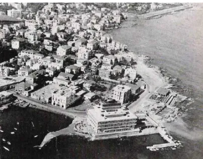
Figure 27: The St. George Hotel in Ain al-Marisa – 1948.85
❖ Independence:
IN 1958, after the independence and during Fouad Chenab presidential period, there were clear intentions by the government toward reform and modernization as a tool to unify the country.
-In 1961, Ecochard was hired again, to create a master plan for the governmental cities. His design integrated the idea of an urban de-concentrating towards new cities linked to the agglomeration by a network of freeways. According to Thabet, this intention was problematic for Beirut, especially for a city which owns an Arabic Mediterranean city form, where the urban network of the city follows the social fabric, the type of city that with its gorgeous past have prosperous and poor, old and young, Muslim and Christian, where the city has its own unique mixture.
Sharing his memory from the neighborhood where he used to live when he was young, and how the changes applied there: “The new Chenab’s mandate accompanied with the implementation of major construction projects, once the revolution ended , it was decided to demolish part of the "MATALWEH neighborhood" to open the way to the boulevard Bchara El Khoury, and then decided to demolish the remaining part of them after a few years to implement the planning of Istiklal Street.Along MATALWEH neighborhood and their inner courtyards new streets, high buildings were built with no shape or character, and the urban fabric of the old neighborhoods was removed without being replaced by a modern system that guaranteed the minimum conditions of urban cohesion” (Thabet 1996, 09).
The city center was to be widely renovated with high-rise buildings and separate circulation according to the Modern Movement principles.
86
The forced modernization that the Chehab’s attempted could not continue to reform the imbalance between the regions and the various social levels, as well the country was heading toward a capitalist economy which cause disintegration of the rural area and caused8 huge migration to the capital.
8 According to an interview with Engineer Mhd Fawaz who used to be
the head of the water and electricity supplement in Lebanon in 1959, that due to the development project that was implemented by President Fouad Chehab, 99% of the Lebanese had electricity, and 94% had drinkable water by 1974 in their houses in the villages and country side.
87
Figure 28: Intersection of Prince Bashir Street and Bchara El Khoury Street - in 60th.Figure 29: Beirut central Business district 1973. Plan by: Oussama Kabbani.(edit by the author)
88
❖ Lebanon civil war (1975,1990):
She is from the spirit of the people, a wine; From its sweat, bread and jasmine. So how did its taste become
89
The context of the Lebanese civil war was quite different in temporality, spatiality of the fights and the nature of destructions.
The war broke out, when Maronites shouted Palestinians on a bus in Ain al-Remmane in 1975, that lead to cracks in the city and society which lead the country to be in a civil war that continued for fifteen years.
The city was divided between Christian quarters which formed the east, and Muslim quarters which formed the west of Beirut, that is what mark the creation of so-called “Green Line” . 9
Down town Beirut during the civil-war: (void in memory)
Downtown Beirut was a main battlefield in the beginning but after a fight in 1976, it became an abandoned area , not dominated by any part , and as well there were no tries to dominating it, sharing Thabet's memory “each person who was able to enter the down town during the war during the case-fire, he could only be surprise for the wired scene where the constructed emerge with non-constructed , where the metal emerge with greenery in the life and death play land “.(Thabet 1996.80)
This didn’t only caused paralysis in the city but as well a void in the memory for the Lebanese people.
9 Which has got its name from the demarcation line set out in the
1949 Armistice Agreements between the armies of Israel and those of its neighbours (Egypt, Jordan, Lebanon and Syria). The Green line wasn’t physical wall, it was just a social definition for the fighting or sniper’s locations, as well, it was defined five main passages by point for the people who moved between the east and the west rarely.
90
Figure 30 :The green line Beirut city. Image by :Almashriq91
The effects of the war in Beirut were devastating, “The destruction into the municipal boundaries of Beirut where estimated at 16% and along the demarcation line and city center serious damages has have been evaluated at 80%. “(Nasr et al 2008 .2).
On regional level, the role of Beirut was deeply affected, and the economical firms were strongly hit. On social level, by the end of the war in 1987, about 27% of the inhabitants were considered refugees. Besides, huge urban transformation happened which was one of the definer for the new urban planning of Beirut, during the war the urban nuclei divided between the east and west and adapted to that.
In the West part of Beirut, the urban space expanded to the West and North towards the sea, where people used to meet.
In the East part of Beirut, the urban space closed to the sea towards the Habour because it was transformed into a fighting zone, while it expanded to the interior to the mountain.
This massive change caused spatial disorganization which led to a division of the city memory into two parts, so it had the effect of Beirut becoming two cities instead of one This massive change caused spatial disorganization which led to a division of the city memory into two parts, so it had the effect of Beirut becoming two cities instead of one.
92
Figure 31: Gabriele Basilico - Beirut, Gourand Street (1991). Image by: Andrea Assandri.93
❖ THE RECOUNSTRUCTION:
The real actions of reconstruction was taken after the (Ta’if Accord) agreement in 1990, according to Maha Yahya “ the agreement was based on the concept of no victor no vanquished, that meant that there were no war crimes persecuted as well how the city was rebuilt”(Carnegie,2018), as well the population displacement which was one of the biggest conflict war trauma effects.
The reconstruction was highly supported as a tool for the recovery, it was linked to healing the social wounds left by the long civil war specially of the downtown because the Souks were playing an ideological role and an example to similarities of Lebanese from different sectarian background and society layers. Even though the physical reconstruction was the objective the reconstruction, the strategy didn’t try to address the population separation that was consequences of the war.
The creation of Solidere:Rafiq Hariri — the businessman who based in entrepreneurial successes outside Lebanon (in Saudi Arabia) — founded “Solidere” in 1994 the private real-estate company, which took over an area of 191 ha, that mainly included Beirut’s historical core, and aimed to create a“modern, mixed use central district with 118 hectares constituting the traditional Beirut city center and a 73-hectare extension toward the sea” (Solidere 2004).
94
Figure 33:I miss you my honey (Beit Beirut). ) Photo by: John Zada.95
The company has a thirty year ‘Master plan’ (1994-2024) that incorporates 472 acres. The aims of the company’s strategy is to push up the economic cycle of the country by reviving it center, that by creating a join stocks, according to Nasr: “the rights of former property-owners and renters were transformed into shares, making up two thirds of the company’s stock. The other third was opened to investors, local and Arabs "(Nasr et al. 2008, 2).
The urban proposal:
The main aims of design of the master plan of the Downtown (BCD) by Solidere were to design the downtown according to three main north-south axes (Figure 34); to open a ring road that would encircle the BCD to facilitate transportation to and out of the BCD; to build a pair of towers (twin towers) representing the modernity of the city; to open AlBurj square (Martyr square) to the sea, and transform it into a boulevard exceeding the width of the Champs Elysées by 10 meters.
96
.
Figure 34:The three major axes of the urban design proposal/ trench ring- road in 1992. .Plan by :Oussama Kabbani (edit by the author).