Ana Rita Correia
Home range analysis of the
semi-resident Bottlenose dolphin (
Tursiops
truncatus
) population of Cardigan Bay
(Wales)
UNIVERSIDADE DO ALGARVE
Faculdade de Ciências e Tecnologia
Ana Rita Correia
Home range analysis of the semi-resident
Bottlenose dolphin (
Tursiops truncatus
)
population of Cardigan Bay (Wales)
MESTRADO EM BIOLOGIA MARINHA
Supervisores: Peter Evans (Bangor University) Ester Serrão (University of Algarve)UNIVERSIDADE DO ALGARVE
Faculdade de Ciências e Tecnologiai
Declaração de autoria de trabalho
Declaro ser a autora deste trabalho, que é original e inédito. Autores e
trabalhos consultados estão devidamente citados no texto e constam da
listagem de referências incluída.
_________________________________________ (Ana Rita Correia)
©Ana Rita Correia
A Universidade do Algarve reserva para si o direito, em conformidade
com o disposto no Código do Direito de Autor e dos Direitos Conexos, de
arquivar, reproduzir e publicar a obra, independentemente do meio
utilizado, bem como de a divulgar através de repositórios científicos e de
admitir a sua cópia e distribuição para fins meramente educacionais ou de
investigação e não comerciais, conquanto seja dado o devido crédito ao
autor e editor respetivos.
ii ACKNOWLEDGEMENTS
There are many people I'd like to thank. This work, as all scientific studies, didn't come from just one person, it's the result of the work and dedication of many, many people.
Firstly, the one person to actually give me the idea to do this project, Dr Mark Fernandez. You said I'd feel like hitting you for giving me this idea and I'd feel frustrated and desperate at some point and I just laughed, but I want to tell you that you were so, so right. It really was a good idea though, so thanks anyway.
I owe a special thanks Dr Colin MacLeod for all the help you gave me, the advice and replies to all those emails I sent, thank you so much for your patience and kindness. Without your help these maps would have never seen the light of day.
I would also like to thank the Sea Watch Foundation staff and volunteers for gathering all the data throughout the years, specially the 2017 volunteers for period 1. Those many days at sea and on landwatch were very important for keeping my sanity when computer work started. A very special thanks to Rhodri and Steph for the help with the Arc GIS program, without you I don't know how I would have done those damned maps.
To Professor Peter Evans and Katrin Lohrengel from the SWF for supervising and providing all the data necessary for this study to happen. A big thanks for professora Ester Serrão from UAlg for looking at my draft.
To everyone at the MBM in UAlg, particularly Monica, Maya, Inês and Teo for all the help with the exams and presentations we did and for all the fun we had.
To my favourite cousin, Olivier for the help with my computer issues.
A very very heartfelt thanks to whoever wrote the website http://abacus.bates.edu/~ganderso/biology/resources/writing/HTWsections.html, thank you so much, you are awesome!!
A great thanks for all the dolphins who let themselves be photographed by the SWF, believe it or not some of them were not very good dolphins and wouldn't let us photograph them, so those who did deserve all the affection I have for them, especially the ones bow ridding and staying close to the boat for a long time, they are really nice good dolphins.
Lastly, to those people that lost hours and days, if not weeks, trying to give all the help they could, for putting up with me all those years, my parents and my brother. It
iii was never easy, I know, but they say the hardest things in life are the best. If we all had to choose a family, I'd never hesitate to choose you three. Thank you for all the support, all the worries you had for me, for letting me scuba dive and drive my motorbike and all that crazy stuff I wanted to do. Most importantly for the support when I was eight and told you I wanted to be a marine biologist. You didn't laugh or said I shouldn't do it, you just supported and encouraged me and I thank the ocean every day for the gift I was given to be part of your family.
To all this people and maybe some that I'm forgetting, thank you for all the help.
"What is a scientist after all? It is a curious man looking through a keyhole, the keyhole of nature, trying to know what's going on."
Jacques-Yves Cousteau
iv ABSTRACT
The common bottlenose dolphin (Tursiops truncatus, Montagu, 1821) belongs to the sub-order Odontoceti and is one of the most widely distributed species of cetaceans. Within this species it is possible to find strict resident populations, semi-resident populations or transient communities. The Cardigan Bay bottlenose dolphin population is one of the two semi-resident populations in the United Kingdom.
With the increasing anthropogenic disturbance, particularly significant for cetacean communities whose geographic ranges are limited or decreasing, the survival of a certain population depends a great deal on its habitat. As a result, understanding the home range of a population is crucial in order to attempt any protection and monitoring measures. Also known as pattern of residency, the home range is the area where the individual spends its time feeding, breeding and nursing the young.
The purpose of this work is to estimate the home range of the bottlenose dolphin population by comparing different group sets in order to infer if there are any dissimilarities between the distributions of the selected groups.
Using photo-identification data from 2007 to 2016 obtained from surveys, combined with other information regarding the individuals, Minimum Convex Polygons and Kernel Density Estimators were calculated and mapped for each group and then compared. Both mean home range (95% KDE) and core areas (50% KDE) were inferred. Mean water depths were also determined for each group.
No significant differences were obtained for gender, markings in the dorsal fin and presence or absence of calf. There were, however differences in distribution for the summer and winter sightings.
Additional important areas for this bottlenose dolphin populations were determined, as well as seasonal differences in distribution. Further surveys are required, mainly at the areas outside the Special Areas of Conservation in Cardigan Bay.
KEY WORDS: Bottlenose dolphin, Home range, Core Area, Kernel density estimators (KDE), Minimum Convex Polygon (MCP), Cardigan Bay.
v RESUMO
O Golfinho-Roaz comum (Tursiops truncatus, Montagu, 1821) pertence à sub-ordem Odontoceti e é uma das espécies de cetáceos mais amplamente distribuídos. Pode ser encontrado em águas costeiras e oceânicas nas regiões tropicais e temperadas dos oceanos e mares. Dentro desta espécie, é possível encontrar populações residentes, cuja faixa residencial é limitada a um local específico, residentes sazonais, que só podem gastar parte do tempo na área e comunidades transitórias. A população de golfinhos roazes de Cardigan Bay (CB), utilizada para este estudo, é uma das duas populações semi-residentes no Reino Unido, sendo a outra em Moray Firth, na Escócia. Atualmente existem duas Áreas Especiais de Conservação (SACs) implementadas em Cardigan Bay: o Cardigan Bay SAC e o Pen Llŷn a'r Sarnau SAC. Apesar das constantes medidas de monitorização e proteção aplicadas, essa população tem sofrido um forte declínio desde 2007.
Com o aumento do impacto antropogénico, particularmente significativo para as comunidades de cetáceos cujas amplitudes geográficas são limitadas ou decrescentes, a sobrevivência de uma determinada população depende muito do seu habitat. Como resultado, a compreensão dos padrões de residência de uma população é crucial para tentar qualquer proteção e medidas de monitorização. Também conhecido como padrão de residência, o home range é a área onde o indivíduo gasta o seu tempo a alimentar-se, a reproduzir-se e a criar as crias.
O objetivo deste trabalho é identificar o home range da população de golfinhos roazes de CB. Ao comparar diferentes grupos, de acordo com certas características (género, data de avistamento, grau de marcações de barbatanas dorsais e presença de crias), é possível inferir as áreas que são mais importadas para cada grupo ou para toda a população, avaliando as desigualdades entre as distribuições dos grupos selecionados, a fim de verificar quais as medidas que podem ser aplicadas para diminuir o impacto exercido sobre estes animais. O uso de dados de foto identificação de 2007 a 2016 obtidos a partir de pesquisas, combinadas com outras informações sobre os indivíduos, os Minimum Convex Polygons (MCP) e os Kernel Density Estimators (KDE) foram calculados e mapeados para cada grupo, sendo depois comparados. O MCP é usado para delinear a área total onde os animais são encontrados, enquanto o KDE determina quais as áreas que são mais utilizadas pela população. O intervalo médio dos padrões de residência, que representa as áreas sem os locais pouco comuns e distantes
vi relativamente à área de ocupação normal do indivíduo, corresponde a 95% de KDE, enquanto a core area, que representa as áreas mais ocupadas pela população, onde ocorreram 50% dos avistamentos, é representada por 50% do KDE. Ambos os home range médio (95% KDE) e core area (50% KDE) foram inferidos. As profundidades médias da água também foram determinadas para cada grupo. Quanto à comparação entre fêmeas e machos, a área total, a média dos padrões de residência obtidos e a core area foram ligeiramente maiores para os machos e as áreas de sobreposição também foram semelhantes. Como as diferenças não foram significativas, a distribuição espacial é semelhante para ambos os sexos. A maior limitação foi o maior número de fêmeas em relação ao número de machos estudados.
O home range relativo aos encontros ocorridos durante os meses mais quentes (1 de Abril até 31 de Outubro - Verão) está localizada principalmente em ambos os SAC e em menor grau no norte de Anglesey. Pelo contrário, o home range dos meses de Inverno (1 de Novembro até 31 de Março) foi mais dispersa, com menor presença na área de Cardigan Bay e maiores concentrações de golfinhos desta população em torno de Anglesey, perto de Liverpool Bay e da Isle of Man. Estes resultados implicam que a maioria dos animais passa o ano em locais completamente diferentes, durante o Inverno encontram-se no norte e passam o Verão no sul, em Cardigan Bay.
Os golfinhos com barbatanas dorsais bem marcadas foram contrastados com golfinhos sem uma barbatana dorsal marcada. As áreas ocupadas pelos golfinhos sem marcas nas barbatanas dorsais sobrepuseram-se com as áreas ocupadas por indivíduos bem marcados. O facto dos animais bem marcados terem uma área estimada maior não significa que eles são mais ou que se expandam em áreas maiores. Os animais bem marcados são muito mais fáceis de identificar, enquanto que uma barbatana dorsal não marcada é muito mais difícil de usar como característica identificável. Deste modo, a área determinada pelos golfinhos sem marcas visíveis nas barbatanas dorsais é menor devido ao menor número de identificações ocorridas quando os encontros ocorreram.
As fêmeas com crias foram avistadas em locais muito mais próximos da costa e mais concentrados nos dois SAC de Cardigan Bay, com algumas fêmeas sendo avistadas na costa norte de Anglesey, enquanto que durante os anos sem crias, as fêmeas não eram apenas vistas nesses locais mas também em Liverpool Bay e na Isle of Man. A sobreposição indicou que as fêmeas com crias não procuram áreas diferentes das ocupadas por outros golfinhos fêmeas sem crias. Em vez disso, as fêmeas sem crias tendem a dispersar-se mais para fora, ocupando toda a área da baía, enquanto as fêmeas
vii
com crias tendem a ficar mais perto da costa em locais mais protegidos. Esta comparação foi limitada pelo, por vezes, reduzido número de avistamentos de mães com crias, dado que, em alguns anos, os encontros não eram suficientes para determinar se a fêmea tinha crias ou não.
Em relação às profundidades, a maioria dos grupos apresentou faixas de profundidade semelhantes com desvios padrão semelhantes. A única diferença notável foi a profundidade média dos avistamentos realizados no Inverno, porém a variação não foi significante, pois o valor do desvio padrão também foi maior para este grupo. Isso pode ser devido ao facto da maioria dos golfinhos estarem localizados fora da área de Cardigan Bay durante o estes meses. Como algumas áreas em torno de Anglesey são ligeiramente mais profundas do que a área de CB, a profundidade seria ligeiramente maior do que nos locais de verão.
Neste estudo foram determinadas áreas importantes para esta população de golfinhos roazes, bem como diferenças sazonais na distribuição. Pesquisas adicionais serão necessárias, principalmente fora das Áreas Especiais de Conservação em Cardigan Bay.
viii TABLE OF CONTENTS
Page
Declaração de autoria de trabalho i
Acknowledgments ii
Abstract iv
Resumo v
Table of contents viii
List of Figures x
List of Tables xii
List of Appendices xiii
List of Abbreviations xiv
1 - Introduction 1
1.1.Cetaceans 2
1.2. The bottlenose dolphin 3
1.3. Group living in bottlenose dolphins 5
1.4. Photo-identification 6
1.5. Home range 8
1.6. The study population 11
1.7. Objectives 11
2 - Materials and methods 13
2.1. Study Area 13
2.2. Data collection, treatment and analysis 15
3 – Results 20
3.1. Females vs males 20
3.2. Summer vs Winter 22
ix 3.4. Females with calves vs Females without calves 26
3.5. Water depth 28
4 – Discussion 29
4.1. Females vs males 29
4.2. Summer vs Winter 30
4.3. Well marked vs Non-marked 31
4.4. Females with calves vs Females without calves 32
4.5. Water depth 33 4.6. Data gathering 34 5 – Conclusion 36 6 - References 39 7 - Appendices 43 7.1. Appendix I 43 7.2. Appendix II 51 7.3. Appendix III 52
x LIST OF FIGURES
Figure Legend Page
Figure 1 Map with the distribution of the common bottlenose dolphin (Tursiops truncatus) in grey. Source: Perrin et al., 2009, p.251
3
Figure 2 Common bottlenose dolphin (Tursiops truncatus). Source: Ana Rita Correia/CRRU.
4
Figure 3 Common bottlenose dolphin (Tursiops truncatus) dorsal fins for photo-identification purposes. a and b are photos of dolphin 014-94W (Gandalf); c and d correspond to dolphin 152-05W. Photo a was taken on July 15th, 2003. Photo b was taken on May 24 th, 2017. Photo c was taken on August 14 th, 2016. Photo d was taken on August 6 th, 2009. Source: Katrin Lohrengel, SWF.
6
Figure 4 Map of the study area: Cardigan Bay, Wales. 13 Figure 5 Map of the two Special Areas of Conservation in
Cardigan Bay, Wales (Cardigan Bay SAC and Pen Llŷn a’r Sarnau SAC).
14
Figure 6 Map of the inner and outer transects to be selected at random at the beginning of each line transect survey conducted in the Cardigan Bay SAC. Souce: Lohrengel and Evans (2015).
15
Figure 7 Map of the transects to be selected at random at the beginning of each line transect survey conducted in the Pen Llŷn a’r Sarnau SAC. Souce: Lohrengel and Evans (2015).
16
Figure 8 MCP of all the females. Each dot corresponds to a single sighting of a female individual.
21
xi sighting of a male individual.
Figure 10 MCP of the summer sightings. Each dot corresponds to a single dolphin sighting that has occurred between April 1st and October 31st.
22
Figure 11 MCP of the winter sightings. Each dot corresponds to a single dolphin sighting that has occurred between November 1st and March 31st.
23
Figure 12 MCP of the well marked dolphins sightings. Each dot corresponds to a single well marked dolphin sighting.
24
Figure 13 MCP of the non-marked dolphins sightings. Each dot corresponds to a single non-marked dolphin sighting.
25
Figure 14 MCP of females with calves sightings. Each dot corresponds to a single sighting of a female dolphin in the company of her calf.
26
Figure 15 MCP of females without calves sightings. Each dot corresponds to a single sighting of a female dolphin when she does not have a calf.
xii LIST OF TABLES
Table Legend Page
Table 1 Number of sightings and dolphins in each groups used for estimating the respective home ranges.
20
Table 2 Table 2 – 95% and 50% KDE areas for females and males as well as the overlap between the two groups.
22
Table 3 95% and 50% KDE areas for winter and summer sightings as well as the overlap between the two groups.
23
Table 4 95% and 50% KDE areas for well marked and non-marked dolphins' sightings as well as the overlap between the two groups.
25
Table 5 95% and 50% KDE areas for sightings of female dolphins with and without calves as well as the overlap between the two groups.
27
Table 6 Average depths where each group of dolphins occurs, with the respective standard deviations and calculated standard errors.
xiii LIST OF APPENDICES
Figure Legend Page
Figure 1.1 Home range of all the females. The 95% KDE (mean home range) is represented in pink whereas the 50% KDE (core area) is represented in red.
43
Figure 1.2 Home range of all the males. The 95% KDE (mean home range) is represented in light blue whereas the 50% KDE (core area) is represented in dark blue.
44
Figure 1.3 Home range of the dolphins sighted in the summer (between April 1st and October 31st). The 95% KDE (mean home range) is represented in orange whereas the 50% KDE (core area) is represented in red.
45
Figure 1.4 Home range of the dolphins sighted in the winter (between November 1st and March 31st). The 95% KDE (mean home range) is represented in light blue whereas the 50% KDE (core area) is represented in dark blue.
46
Figure 1.5 Home range of the well-marked dolphins. The 95% KDE (mean home range) is represented in dark green whereas the 50% KDE (core area) is represented in light green.
47
Figure 1.6 Home range of the non-marked dolphins. The 95% KDE (mean home range) is represented in tan whereas the 50% KDE (core area) is represented in burgundy.
48
Figure 1.7 Home range of the female dolphins sighted in the years they were nursing their calves. The 95% KDE (mean home range) is represented in light green whereas the 50% KDE (core area) is represented in orange.
49
Figure 1.8 Home range of the female dolphins sighted in the years they did not have calves. The 95% KDE (mean home range) is represented in light blue whereas the 50% KDE
xiv (core area) is represented in dark blue.
Figure 2.1 Map of the study area depicting the water depth, in meters.
51
Figure 3.1 Effort form to fill in when on line transect surveys. Every line must be recorded every 15 minutes in the absence of bottlenose dolphins and every 3 minutes when an encounter is happening. Source: Lohrengel and Evans, 2015.
52
LIST OF ABBREVIATIONS
Abbreviation Meaning
CB Cardigan Bay
KDE Kernel Density Estimator
MCP Minimum Convex Polygon
PVC Percentage Volume Contours SAC Special Area of Conservation
1 1. INTRODUCTION
Despite being an emblematic and widespread group, small cetaceans are heavily impacted by anthropogenic activities (Cheney et al., 2013). The life history characteristics of these animals, since they are K-selected species, as well as the impacts caused by human activities on the marine habitats, particularly in near-shore environments, are reasons for their vulnerability (Ross et al., 2011).
Human disturbance causes a particularly significant impact on cetacean communities whose geographic ranges are limited or decreasing. It is important to understand that the survival of a certain population depends a great deal on its habitat (Ross et al., 2011). Consequently, understanding the home range of a population is crucial in order to attempt any protection and monitoring measures (Ingram and Rogan, 2002; Ross et al., 2011; Dwyer et al., 2016; Sprogis et al., 2016).
As the population is presently declining (Feingold and Evans, 2014a; Lohrengel and Evans, 2015), more conservation measures are necessary in order to reverse this trend, as these animals are being increasingly affected by anthropogenic activities.
This study aims to estimate the home range of the bottlenose dolphin population by comparing different group sets in order to infer if there are any dissimilarities between the distributions of the selected groups. By analysing the core areas it is possible to determine the most important areas to protect, assessing if there are different areas for opposite groups and how best to manage them, decreasing the pressure exerted on the population.
2 1.1.Cetaceans
The order Cetacea, comprised of 87 species of whales, dolphins and porpoises (Hoyt, 2011) is divided into two sub-orders, the Mysticeti (baleen whales) and the Odontoceti (toothed whales), which include dolphins and porpoises (Evans and Raga, 2012). The two suborders have radiated during the Oligocene from the archaeocetes, primitive toothed cetaceans that emerged from terrestrial mammals (Fordyce, 1980).
Cetaceans vary in length, from 1.5m to 33m and inhabit marine ecosystems, although some species can be found in lakes and river systems. Having descended from mammals, cetaceans share certain traits with their terrestrial relatives, such as being air-breathing homeotherms (Alves, 2013).
These aquatic mammals are well adapted to living in aquatic ecosystems, with a streamline shaped body, flat paddle-shaped forelimbs and no external hindlimbs, having a horizontal tail - the fluke. In some species it is possible to find a dorsal fin. The nasal opening is located on top of the head in addition to reduced appendages (internal reproductive organs as well as internal ears) in order to decrease the water resistance (Fordyce, 1980; Evans and Raga, 2012; Jefferson et al., 1993). Furthermore, insulation is provided through a thick layer of sub-dermal fat named blubber, allowing these animals to occupy a wide variety of temperatures, from 2ºC to over 30ºC (Evans and Raga, 2012; Alves, 2013).
Despite all this similarities, there are quite a few differences between the two sub-orders. The mysticetes are often larger than the toothed whales and possess baleen plates, a feeding apparatus that allows the animal to filter prey organisms present in the water column. On the other hand, odontocetes feed on individual large food items, such as fish, cephalopods and crustaceans, using their teeth. Exceptions can be found, as these do not erupt through the gums of the females of the family Ziphiidae (Fordyce, 1980; Evans and Raga, 2012).
The other main distinction regards the nasal cavity, known as blowhole. Mysticetes have two blowholes, whereas odontocetes only possess one (Jefferson et al., 1993; Evans and Raga, 2012).
Diverse studies have been conducted in order to gather knowledge on these animals, however, in opposition to terrestrial animals, aquatic mammals are not frequently visible, since they spend most of their time underwater (Gowans et al.,2007).
Their aquatic lifestyle presents a challenge for scientific studies, as it is often complicated to observe or detect the animals. Moreover, these species are highly mobile
3 and may occupy a wide geographical area, including sometimes great depths. Most research studies are concentrated in small areas, which can hinder the possibility to gather information if the animals occur in a greater range or even in neighbouring countries (Evans and Hammond, 2004; Alves, 2013; Nuuttila et al., 2013).
In addition, the large body size, fragility, endangered status and the high levels of public attention towards these aquatic mammals can lead to a more demanding way to acquire knowledge from cetaceans (Alves, 2013).
1.2. The bottlenose dolphin
The common bottlenose dolphin (Tursiops truncatus, Montagu, 1821) belongs to the sub-order Odontoceti and is one of the most widely distributed species of cetaceans (Fig. 1). It can be found in both coastal and oceanic waters in the tropical and temperate regions of oceans and seas. Some populations reside in rivers and estuaries (Gregory and Rowden, 2001; Santos et al., 2007).
It is probably the most recognised species of cetaceans, featuring in several movies and due to its captivity in zoos and dolphinariums. Despite this, there has been a debate in the scientific community regarding the systematics of this genus. Presently, the genus Tursiops consists of three distinct species: Tursiops truncatus, T. aduncus and T. australis (Connor et al., 2000; Charlton-Robb et al., 2011).
Figure 1 - Map with the distribution of the common bottlenose dolphin (Tursiops truncatus) in grey. Source: Perrin et al., 2009, p.251
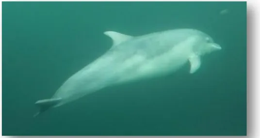
4 Members of this species display great variation in size and coloration. Adults can measure between 1.9 to 4.1meters and weigh between 150 to 650kg, with the males typically slightly larger than the females. Coloration can range between dark gray to light grey with a white belly (Fig.2). Individuals are usually found in groups (Shirihai, 2006).
In this species, two disparate strategies have been considered: the coastal resident populations and the wide ranging oceanic populations. In resident populations, since the amount of prey and resources available is relatively small, large groups would be disadvantageous. For that reason, group size in these communities is reduced, leading to lower competition for food. Since these populations inhabit locations with lower risk of predation, safety in numbers is not a necessity. On the other hand, oceanic groups have a tendency to expand over large areas, as prey availability is often irregular and in low concentration. Frequently, these communities must rely on a big group, as refuge from predators is scarce and prey schools tend to concentrate in small regions, with large areas without any food available. In both these cases, a large community provides protection and increases foraging and ability to catch prey (Gregory and Rowden, 2001; Gowans et al., 2007).
It is, however, quite complicated to conclude with certainty the strategies and patterns of movement of the oceanic groups, as the act of studying them is complex, particularly considering its large area of distribution. Furthermore, offshore bottlenose communities have a tendency to present a dissimilar social structure, exhibiting
Figure 2 - Common bottlenose dolphin (Tursiops truncatus). Source: Ana Rita Correia/CRRU.
5 relatively lower low-term associations and greater ranges (Gregory and Rowden, 2001; Gowans et al., 2007).
Gowans et al (2007) have also referred that, based on genetic studies, inshore and offshore ecotypes display marked genetic differences. For that reason, both are isolated from each other on a reproductive level.
1.3. Group living in bottlenose dolphins
When encountering members of the species Tursiops truncatus, it is possible to observe several individuals. Like most delphinids, these animals form groups or pods. A group is a set of individuals that display stronger associations amongst each other than with the other members of the population over large periods of time (Connor et al., 1998).
There are several advantages in forming groups such as the decrease in mortality due to predation, increase in detection and acquisition of prey and other resources and a bigger amount of individuals for reproduction. Moreover, the probability of acquiring knowledge through learning and social interactions increases when an individual is inserted in a group (Gowans et al., 2007).
However, group living may increase competition for food and other resources as well as probability of spreading certain illnesses or parasites (Gowans et al., 2007).
Despite the existence of a few disadvantages, grouping is quite common in cetaceans. In fact, Connor et al (2000) refers that all populations of bottlenose dolphins appear to form what was called fission-fusion groups. In this grouping strategy, associations formed between different animals often change in composition for small periods of time.
Depending on the activity in progress at the time, different groups may be defined, nevertheless each individual can be considered to be in more than one simultaneously (Gowans et al., 2007). One example could be of a nursery group, where several females have grouped to take care of calves, that join a feeding group.
The decrease or absence of competition is quite beneficial for the success of the group or groups and cooperation can exist even when the animals are not related to each other (Gowans et al., 2007).
6 1.4. Photo-identification
Photo identification is a method based on the analysis of photographs whose goal is to identify and recognise different individuals (Fig.3).
According to Würsig and Jefferson (1990) studies comparing natural marks in cetaceans have started in the early 1970's.
One main advantage to using this particular method is that it does not harm the animals sampled. It also provides an array of information with a relatively low cost (Evans and Hammond, 2004).
Photo-identification can be useful in assessing movement and population parameters, namely life history information, such as age of sexual maturity, reproductive and total life span, calving intervals, length of nursing, and, in some cases, mortality and disease rates. Group composition and behaviour of the population is possible to be inferred when all the individuals are accounted for. Area distribution as well as short term movement patterns and migrations are also possible to be determined,
Figure 3 - Common bottlenose dolphin (Tursiops truncatus) dorsal fins for photo-identification purposes. a and b are photos of dolphin 014-94W (Gandalf); c and d correspond to dolphin 152-05W. Photo a was taken on July 15th, 2003. Photo b was taken on May 24 th, 2017. Photo c was taken on August 14 th, 2016. Photo d was taken on August 6 th, 2009. Source: Katrin Lohrengel, SWF.
7 when the photo-identification occurs in different locations (Würsig and Jefferson, 1990; Evans and Hammond, 2004; Connor and Krutzen, 2015).
Reliable data must be attained for these studies, in order to avoid getting biased information. The natural marks used for the recognition of the animal must be discernible over time as well as be unique to that specific individual. In most cases this condition is easily met, since most marks will seldom change beyond recognition even when other marks appear in the dorsal fin/fluke. In addition, most marks will be present throughout the individual's lifetime (Würsig and Jefferson, 1990; Evans and Hammond, 2004).
Another consideration when photographing the individuals is that most dolphins or whales acquire marks or nicks as they get older, hence the probability to recognise a calf or a juvenile is much lower. Fortunately, marks tend to appear as the individual gets older, improving the possibilities of identification (Würsig and Jefferson, 1990).
Despite most photo-identification work only accounting for the marks, nicks and amputations present in flukes or dorsal fins as well as its shape, some studies (Katona and Whitehead, 1981; Würsig and Jefferson, 1990; Hartman et al., 2014) have pointed out other ways to positively identify cetaceans, such as using pectoral fins in order to identify Humpback Whales (Megaptera novaeangliae), as well as pigment patterns in different species of whales. In addition, shading of the fin and upper body, wounds and foreign objects present in the animal can be useful when recognising a specific individual. One trait more commonly found in the Risso's dolphins (Grampus griseus) is the scarification pattern present on the animal's dorsal fins and bodies.
Despite all the different characteristics, all these must be identifiable and including poor quality photographs may lead to animals not being recognized or correctly named. Even when the photographs have a good quality, not all animals in the population may bear distinguishable markings along with the fact that in some species most individuals do not hold natural lasting marks or scars. (Evans and Hammond, 2004).
Moreover, other approaches have been used in order to collect the same type of information as the one gathered through photo-identification. Some whale species have been identified from airplanes, however delphinids are not possible to identify using this method. Another method used is underwater acoustics, which does not require visualisation of the animals. However, the animals must be vocalising for this method to be successfully employed and some species only do so throughout specific times of the
8 year. Underwater photography is also a potentially important method, as the animals are more frequently under water (Würsig and Jefferson, 1990; Evans and Hammond, 2004).
Despite having some disadvantages, photo-identification can be applied to several studies, such as habitat preference (MacLeod et al., 2007). By understanding the species' habitat preference, it may be possible to predict its response to changes of the environment, mitigating the impact of human interactions with cetaceans. Another use of employing photo-identification is to ascertain home range as well as determining resident and non-resident cetacean populations (Hartman et al., 2014; Hartman et al., 2015). Additionally, mark-recapture methods applied to photo-identification are frequently used in monitoring programs, often improving conservation efforts (Evans and Hammond, 2004).
1.5. Home range
Burt (1943) has defined home range, also known as pattern of residency, as the area where the individual spends its time feeding, breeding and nursing the young (Defran et al., 1999; Ingram and Rogan, 2002).
In the past this concept has been used in studies of terrestrial mammals (Ingram and Rogan, 2002), however residence patterns have increasingly been used to determine important habitats for populations of aquatic mammals (Dinis et al., 2016).
Nevertheless, not all species and even populations of the same species will occupy the same exact locations: some populations can use the same home range for decades and other populations may display temporary or seasonal migrations away from the area. Sometimes it is even possible to find different home ranges for different individuals in the same geographical area (Defran et al., 1999).
In bottlenose dolphins, it is possible to find strict resident populations, whose home range is limited to a specific location, seasonal residents, which may only spend a portion of time in the area and transient communities (Papale et al., 2016).
Using location data, the home range can be estimated through two simple widely applied methods: MCP (Minimum Convex Polygon) and KDE (Kernel Density). MCP is used to outline the total area where the animals are found. However, this approach tends to overestimate the home range, as it builds a convex polygon of the area used, assuming that the animals use this area equally. Odd locations, far away from the normal area used will induce a biased home range, as MCP does not take into account
9 that most animals tend to spend more time in some areas than other (Anderson, 1982; MacLeod, 2013; Sprogis et al., 2016).
In order to determine which areas are more frequently used by the population a different method must be applied. The KDE assumes the areas with a greater number of sightings are more important for the individuals than the areas with low density of records. In this approach, 50% and 95% KDE polygons are created. Mean home range, that represents the areas without the odd locations far away from the individual's normal range, corresponds to 95% KDE whereas the core area, which stands for the most occupied areas by the population, where 50% of the total number of sightings occurred, is represented by 50% KDE (Anderson, 1982; Hauser et al., 2007; MacLeod, 2013).
The original KDE was used for populations within study areas that did not contain any barriers to movement. For offshore cetacean species, whose habitat allows them to move freely, this method can be used. However, for coastal cetacean population, such as the Cardigan Bay bottlenose dolphins, this implies an overestimation of the home range, as the coastline acts as a barrier to the movement. In order to avoid a biased home range estimation the method used must take into account the presence of barriers in the study area (MacLeod, 2013; Sprogis et al., 2016).
Other than the presence of barriers to the movements of the animals, home range may be affected by physical habitat features, such as depth, variability in climate, temperature, salinity, tidal cycles and other ocean processes (Ingram and Rogan, 2002; Hauser et al., 2007).
Individuals use their home range to gather food and other resources, to avoid predators and attain conditions for their survival. Therefore, home range is not a fixed location in time. Ecological conditions may alter, causing modifications on the distribution patterns with the goal to increase the group's chances of survival and reproductive success (Lusseau, 2005; Hauser et al., 2007; Powell and Mitchell, 2012).
These changes in distribution may also include areas known by the animal, yet were not visited before (Powell and Mitchell, 2012). By studying home range, particularly in cetaceans, the researcher must take into account not only the areas where the animals can be found, but also the social organisation and behaviour of the populations (Hauser et al., 2007).
In an innovative study, Powell and Mitchell (2012) have attempted to determine how an individual would perceive its home range and have presumed that a residence pattern originates from a combination of resource availability (the environment) and the
10 animal's understanding of that environment, its cognitive map. By determining how the individual's decision-making process works in regards to changes in the environmental conditions, home range would be more accurately estimated.
It is, however, still not possible to determine a home range based on this method. Consequently, quantitative statistical approaches are presently used. One other disadvantage is the dynamism of residency patterns, often altering in a timescale that would not allow an effective data collection for its estimation (Powell and Mitchell, 2012).
There are several methods that can be used to obtain information to estimate a population's home range. Previously, visual data was the main method used (Sveegard et al., 2011). Nevertheless, other techniques started being employed in order to attain the same information. These include use of telemetry (Powell and Mitchell, 2012) and multiple acoustic methods (Sveegard et al., 2011; Nuuttila et al., 2013).
Although a decrease in resource availability can play an important role in shifting a population's home range (Defran et al., 1999; Gowans et al., 2007; Sveegard et al., 2011), anthropogenic disturbance caused by fishery activities as well as overall boat traffic and noise are cause for concern regarding the dolphin's welfare. For dolphins, boat presence could lead to physical injuries from collisions, hearing problems from the excessive noise, more time spent foraging due to avoidance of areas with large amounts of boats (Lusseau, 2005; Pierpoint et al., 2009; Papale et al., 2016).
Information regarding residency patterns can be applied in conservation and management efforts of resident populations. By determining the most frequently used areas for a certain population or group, considered to be the locations where food and other resources are more abundant, it would be possible to more effectively protect it, creating Marine Protected Areas or decreasing anthropogenic impact close to that area (Sveegard et al., 2011; Hartman et al., 2015). One example was the creation of the Gully Marine Protected Area, in Nova Scotia due to the presence of a resident population of the northern bottlenose whale (Hyperoodon ampullatus) (Hartman et al., 2015).
11 1.6. The study population
The Cardigan Bay bottlenose dolphin population is one of the two semi-resident populations in the United Kingdom, the other being the Moray Firth, in Scotland (Feingold and Evans, 2014a).
Estimates of the size of the population vary between 121 and 230 individuals, with a greater presence during the summer season. On the other hand, some individuals keep being sighted in the bay during the winter months (Feingold and Evans, 2014a).
Previous studies have determined that several individuals have been moving towards the north, mostly at the north coast of Anglesey, with sightings recorded as far as Liverpool Bay and the Isle of Man during the summer months, which leads to the conclusion that these dolphins no longer inhabit the Cardigan Bay area during the summer (Gregory and Rowden, 2001; Pierpoint et al., 2009; Feingold and Evans, 2014a; Lohrengel and Evans, 2015).
Until recently the dolphin population was growing in numbers. However, with the increase in boat disturbance, the decrease in prey and overall anthropogenic impact the population has suffered a decline (Feingold and Evans, 2014a; Lohrengel and Evans, 2015).
1.7. Objectives
The present study aims to assess the home range of the bottlenose dolphin population of Cardigan Bay using long-term photo-identification data in order to improve the knowledge of this population and contribute for its conservation.
The objectives of this study are as follows:
- Compare the Minimum Convex Polygon (MCP) as well as 50% and 95% Kernel Density Estimators (KDE) of males vs females.
- Compare the MCP as well as 50% and 95% KDE of the individuals sighted in the summer vs individuals sighted in the winter.
- Compare the MCP as well as 50% and 95% KDE of the dolphins without marks in the dorsal fin vs heavily marked dolphins.
- Compare the MCP as well as 50% and 95% KDE of females with calves vs females without calves.
12 These objectives are designed to answer the following questions:
(1) Do females and males occupy the same areas and where do they stay?
(2) Does the population remain at the same location during the summer and the winter? If not, where do they go?
(3) Is there a difference in identification between dolphins with a well-marked dorsal fin and dolphins without marks in their dorsal fins?
(4) Do bottlenose dolphin mothers stay in different locations with their calves than when they don't have a calf? Is there a place in Cardigan Bay where mothers do not go with their calves or a place only mothers and calves go to?
13 2. MATERIALS AND METHODS
2.1. Study Area
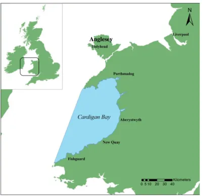
Located in West Wales, Cardigan Bay is the largest bay of the British Isles with an estimated area of 5000 km2 measuring over 100km between its northern (the Llŷn Peninsula) and southern boundaries (St David’s Head). It is surrounded by the coastline of Wales on three sides and opens to the Irish Sea on its western border (Fig.4). Its greatest depth reaches about 50 m, however the average depth is approximately 40 meters. Its depth increases from east to west with very gentle slopes (Gregory and Rowden, 2001; Anon, 2007; Lohrengel and Evans, 2015).
Cardigan Bay is relatively sheltered, having calm waters, particularly at small embayments within the bay. Salinity is greater in the south and lower near the coast due to freshwater input from rivers and rainfall (Anon, 2007).
The seabed of the bay is diverse in its nature, being comprised of sand and broken shells, gravel, shingle and mud (Gregory and Rowden, 2001; Anon, 2007).
Boat traffic is frequent, mainly in the summer months, with tourist activities such as water sports and recreational boat trips, with wildlife boat trips actively chasing the semi-resident population of bottlenose dolphins present in the bay (Gregory and Rowden, 2001).
Figure 4 - Map of the study area: Cardigan Bay, Wales.
14 Under the European Community's Habitats Directive, two Special Areas of Conservation (SACs) were implemented in Cardigan Bay: the Cardigan Bay SAC in the south and the Pen Llŷn a’r Sarnau SAC in the north (Fig.5).
Proposed in 1996, both officially started in 2004, with the main purpose of protecting the marine wildlife present in both areas (Anon, 2007; Evans and Pesante, 2008; Pierpoint et al., 2009)
The Cardigan Bay Special Area of Conservation is located from the Teifi Estuary to Aberaeron. It has approximately 960km2 and its primary objective is to protect the semi-resident bottlenose dolphin population as well as other species and habitat features, such as the Atlantic Grey Seal (Halichoerus grypus), the River Lamprey (Lamptera fluviatilis), the Sea Lamprey (Petromyzon marinus), reefs, submerged sea banks and submerged or partially submerged sea caves (Anon, 2007; Evans and Pesante, 2008; Pierpoint et al., 2009; Lohrengel and Evans, 2015).
The Pen Llŷn a’r Sarnau Special Area of Conservation, between the Dovey Estuary and around the Lleyn Peninsula, has an estimated area of 1460km2. Originally designed to protect mostly habitat features, such as estuaries, reefs, shallow bays and inlets, mudflats and subtidal sand banks, as well as the European Otter (Lutra lutra) it
Figure 5 - Map of the two Special Areas of Conservation in Cardigan Bay, Wales (Cardigan Bay SAC and Pen Llŷn a’r Sarnau SAC).
Irish Sea
Cardigan Bay
15 later encompassed the Bottlenose Dolphin (Pen Llŷn cSAC Plan, 2001; Evans and Pesante, 2008; Lohrengel and Evans, 2015).
2.2. Data collection, treatment and analysis
The dataset used in this study was collected by the Sea Watch Foundation (SWF) between 2007 and 2016. Land-based and boat-based surveys were conducted throughout the year in Cardigan Bay, around the coast of Anglesey, in Liverpool Bay and at the Isle of Man.
Surveys occurred mainly between April and October, however there have been sightings in other months, particularly in the north of Anglesey.
While collecting data, environmental conditions need to be favourable, with sea state 3 or less, the visibility must be over 1.5km and absence of precipitation (Lohrengel and Evans, 2015).
Boat-based data was collected from dedicated line transect surveys aboard motorised vessels with members of the SWF as well as trained volunteers. The line transects had been previously defined (Figures 6 and 7) and are chosen at random at the beginning of each survey.
Figure 6 - Map of the inner and outer transects to be selected at random at the beginning of each line transect survey conducted in the Cardigan Bay SAC. Souce: Lohrengel and Evans (2015).
Inner transects
16 As seen in Lohrengel and Evans (2015), there are four observers (two primary and two independent) actively searching for the animals as well as a researcher recording effort data at all times throughout the survey. Environmental data such as visibility, precipitation, glare, sea state and swell are recorded on the effort forms every 15 minutes. Other information such as boat speed and course, location coordinates and presence or absence of other vessels in the area is also registered (Fig. 3.1 - Appendix III). When bottlenose dolphins are present, effort must be done every three minutes. Data recorded includes location (geographical coordinates), behaviour, group size and composition, video and underwater video recordings. Occasionally, underwater acoustic data and drone footage can also be attained. Information such as the distance from the boat, first cue the observer spotted (dorsal fin, fluke, back, head, blow,...), reaction to the boat and the angle where the animal was first spotted is also part of the data collected.
Photo-identification is also carried out, when possible, both in the line transect and the ad libitum surveys. The latter are conducted when weather conditions are not ideal or aboard wildlife watching vessels. Photographs were taken using a Canon EOS 40D or a Canon EOS 7D camera body with 18-200mm, 18-300mm or 75-300mm
Figure 7- Map of the transects to be selected at random at the beginning of each line transect survey conducted in the Pen Llŷn a’r Sarnau SAC. Souce: Lohrengel and Evans (2015).
17 telephoto zoom lens (Lohrengel and Evans, 2015). The trips aboard the whale watching vessels are only carried out at the near-shore area of the Cardigan Bay SAC.
On land-based surveys it is necessary to document the number of animals (adults and calves) that can be seen along with the location they were first spotted. Additionally, all boat encounters must be registered as well as the distance of the animals to the boats. The number of vessels present in the water is another feature that must be written down.
All research was carried out under licence from Natural Resources Wales and following all the rules regarding interactions with cetaceans.
After the encounters, all data is treated. Each dorsal fin photograph must have enough quality so that it can be used to confidently identify the individual. If this is not possible, the photo must be deleted. After the photographs are determined to have sufficient quality, each one is given a code. An example of the code is 160124_001_dunbar_RCO_001, where 160124 is the date (year 2016, on January 24th), 001 represents the encounter number, dunbar is the name of the boat (when the survey is land-based, this should be replaced with "land"), RCO corresponds the initials of the photographer (Rita COrreia) and the last three numbers stand for the consecutive order of the photograph.
After the photographs are batch renamed, they must be cropped in order to obtain a photograph that shows the fin and any scars present on the body that could be used to more easily identify the individual. All pictures of the same individual must be given the same code at the beginning of the name.
The dorsal fin is then compared with the photographs catalogued. There are three different catalogues: two containing all the unmarked dorsal fins, divided into the left and right catalogues, corresponding to the side represented in the photograph. The third catalogue is divided into two sub-catalogues, the well-marked and the slightly marked.
After a match is found or the animal is not on the catalogue, it must be validated. The validation process will be completed by someone else, in order to have certainty that the identification is correct. Afterwards, the sighting information is stored to be used for future studies.
18 In this study the dataset had the following information: name, sex, date of sighting and geographic coordinates. All sightings from the marked catalogue were used, however, in order to prevent using the same animal more than once, only data from the left catalogue was analysed.
All dolphins not sighted a minimum of 4 years between 2007 and 2016 were excluded from the dataset. The individuals had to have seen sighted in at least four different years in order to insure that these were not transients or occasional visitors.
All the dolphins present in the dataset were divided into several different datasheets, according to the characteristics analysed. A minimum of 30 sightings were used for determining home ranges, as done in other studies (Hartman et al., 2014; Hartman et al., 2015), in order to obtain an accurate analysis.
In order to compare females and males, the dataset was divided into only females and only males. Possible females and possible males were excluded from this study, as sexing is often difficult and no confirmation of these animals' gender could lead to a biased home range estimation.
When comparing summer and winter, all the sightings were ordered by their date of occurrence. Sightings between April 1st and October 31st were classified as summer sightings. Between November 1st and March 31st occurred the winter sightings. All dolphins that did not have both winter and summer sightings were excluded.
In the well-marked against not-marked study, only the well-marked and the non-marked left catalogued individuals in the dataset were included.
As for the females with calves and females without calves, every female that had been seen next to calf at least 3 times in the same year was considered a mother in that year. Only females who had previously been mothers were used in the comparison. Furthermore, information regarding females and calves from the year 2016 was not available for this study, as a result the sightings used occurred between 2007 and 2015.
All data was analysed using the ArcGIS Desktop 10.1 software. The geographic coordinate system used was WGS 1984 whereas the projected coordinate system was a custom Transverse Mercator (Latitude of Origin: 51; Central Meridian: -1).
In order to calculate the total area used by each group of individuals an MCP (Minimum Convex Polygon) was estimated (Hartman et al., 2015). Considering the fact that cetaceans are exclusively aquatic mammals, all areas of the MCP that fall on land were removed. For each group to be compared a map was created and the total area was calculated.
19 The residency patterns are calculated using kernel density estimators (KDE) in order to determine the distributions and space use of each group (Hauser et al., 2007; Dwyer et al., 2016). Once again, all areas that fall on land must be excluded, making this a kernel analysis with barriers. To remove the land from the study a polygon data layer, whose coordinate values are as follows: Top: 300000; Right: 90000; Bottom: -60000; Left: -170000.
Subsequent to attaining the map with the KDE values with barriers, two PVCs (Percentage Volume Contours) were created for each group of dolphins, the 95%PVC that represents the mean home range and the 50%PVC, which corresponds to the core area (Hauser et al., 2007). Using the 50% and 95% polygons previously created, the whole area was then calculated for each different group.
The areas for each set of individuals to be compared were combined into a single polygon in order to determine the overlap between each set of dolphins. Percentage of overlap was also determine for both methods.
After all the comparisons, a water depth raster was added in order to determine the mean depth for each group, using the 95% PVCs previously attained, with the determination of the mean water depth and standard variation of each group.
The standard error for each group was calculated as follows:
where corresponds to the standard deviation obtained and n is the total number of sightings for the group.
20 3. RESULTS
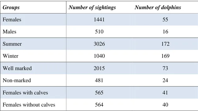
The main dataset contained a total of 4232 sightings from 189 dolphins. As previously stated, the dataset was divided into several groups. The number of sightings and dolphins analysed in each groups is depicted in Table 1.
Groups Number of sightings Number of dolphins
Females 1441 55 Males 510 16 Summer 3026 172 Winter 1040 169 Well marked 2015 73 Non-marked 481 24
Females with calves 565 41
Females without calves 564 40
3.1. Females vs Males
Though the number of females was greater than the number of males in the dataset, the Minimum Convex Polygon (MCP) was higher for the males (9715,30 km2) than the females (8812,05 km2). However, the area of overlap represents a big portion of both MCP areas (7512,54 km2), with a similar percentage of overlap for both groups (77.3% for males and 85.3% for females). Both maps with the females and males' MCPs are represented by figures 8 and 9.
The Kernel Density Estimate areas calculated for both females and males can be found on Table 2, while the maps are located in figures 1.1 and 1.2 (Appendix I), respectively.
Table 1 – Number of sightings and dolphins in each groups used for estimating the respective home ranges.
21
Female sighting Female MCP
Male sighting Male MCP
Figure 8 – MCP of all the females. Each dot corresponds to a single sighting of a female individual.
Figure 9 – MCP of all the males. Each dot corresponds to a single sighting of a male individual.
22 The percentage of overlap for the females was 73.3% (95% KDE) and 90.8% (50% KDE). For males was 69.5% (95% KDE) and 80.9% (50% KDE).
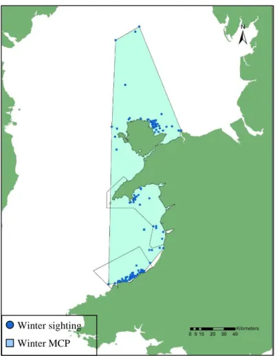
3.2. Summer vs Winter
When comparing sightings that occurred in the cold and hot months, the winter MCP was higher (8139,72 km2) than the summer MCP (6373,77 km2). The overlap consisted of 5052,90 km2(figures 10 and 11). The percentage of overlap was 79.3% for the summer and 62.1% for the winter.
In table 3 can be found the KDE areas for each groups. The maps generated are located in figures 1.3 (summer) and 1.4 (winter) (Appendix I).
Method
Females
Males
Overlap
KDE 95% (km
2)
883,70
932,25
647,50
KDE 50% (km
2)58,63
65,75
53,21
Summer sighting Summer MCP
Figure 10 – MCP of the summer sightings. Each dot corresponds to a single dolphin sighting that has occurred between April 1st and October 31st.
Table 2 – 95% and 50% KDE areas for females and males as well as the overlap between the two groups.
23
Method
Summer
Winter
Overlap
KDE 95% (km
2)
1805,92
1444,13
723,85
KDE 50% (km
2)137,57
143,49
38,75
The percentage of overlap for summer was 40.1% (95% KDE) and 28.2% (50% KDE). For winter was 50.1% (95% KDE) and 27.0% (50% KDE).
Winter sighting Winter MCP
Figure 11 – MCP of the winter sightings. Each dot corresponds to a single dolphin sighting that has occurred between November 1st and March 31st.
Table 3 –95% and 50% KDE areas for winter and summer sightings as well as the overlap between the two groups
24 3.3. Well marked vs Non-marked
In relation to the comparison between the well marked and the non-marked dolphins, the MCP regarding the well marked individuals was 2,14 times higher (11666,74 km2) than the MCP of the non-marked dolphins (5454,76 km2). The overlap consisted of 5454,76 km2 (figures 12 and 13), while the percentage of overlap was 100% for the unmarked individuals and 46.8% for well marked individuals.
In table 4 are represented the mean home range and core area for each groups. The maps generated are located in figures 1.5 (well-marked) and 1.6 (non-marked) (Appendix I). Well marked dolphin sighting - Well marked dolphins MCP
Figure 12 – MCP of the well marked dolphins sightings. Each dot corresponds to a single well marked dolphin sighting.
25
Method
Well marked
Non-marked
Overlap
KDE 95% (km
2)
2464,15
1275,44
1164,14
KDE 50% (km
2)181,82
58,05
57,31
The percentage of overlap for well-marked dolphins was 47.2% (95% KDE) and 31.5% (50% KDE). For non-marked individuals was 91.3% (95% KDE) and 98.7% (50% KDE). Non-marked dolphin sighting Non-marked dolphins MCP
Figure 13 - MCP of the non-marked dolphins sightings. Each dot corresponds to a single non-marked dolphin sighting.
Table 4 –95% and 50% KDE areas for well marked and non-marked dolphins' sightings as well as the overlap between the two groups
26 3.4. Females with calves vs Females without calves
When comparing the females with and without calves, the females without calves had an MCP of 9788,94 km2, 1.75 times greater than the females with calves, with an MCP of 5590,31 km2. The areas overlapped 5561,23 km2 (figures 14 and 15). Percentage overlap was much greater for females with calves (99.5%) than for females without calves (56.8%).
Table 5 contains the mean home range and core area for each groups. The maps representing the 95% and 50% KDE are located in figures1.7 (females with calves) and 1.8 (females without calves) (Appendix I).
Figure 14 - MCP of females with calves sightings. Each dot corresponds to a single sighting of a female dolphin in the company of her calf.
Female with a calf sighting
Female with a calf MCP
27
Method
With calves
Without calves
Overlap
KDE 95% (km
2)
1250,90
1987,60
1162,24
KDE 50% (km
2)62,56
137,68
61,60
The percentage of overlap for females with calves was 92.9% (95% KDE) and 98.5% (50% KDE). For females without calves it was 58.5% (95% KDE) and 44.7% (50% KDE).
Figure 15 - MCP of females without calves sightings. Each dot corresponds to a single sighting of a female dolphin when she does not have a calf.
Female without a calf sighting Female without a calf MCP
Table 5 –95% and 50% KDE areas for sightings of female dolphins with and without calves as well as the overlap between the two groups
28 3.5. Water depth
The average water depth where each group occurs is depicted in table 6 as well as the standard deviations obtained and the standard errors calculated for each group.
The map obtained illustrating the depth of the study area is located in Appendix II (Fig. 2.1).
Groups Average Depth (m) Standard deviation Standard Error
Females -19,56 9,10 0,24 Males -19,09 8,56 0,38 Summer -18,42 9,36 0,17 Winter -26,61 15,88 0,49 Well marked -20,55 10,90 0,24 Non-marked -20,80 10,09 0,46 With calves -20,24 9,42 0,40 Without calves -20,72 10,20 0,43
Table 6 –Average depths where each group of dolphins occurs, with the respective standard deviations and calculated standard errors.
29 4. DISCUSSION
The present study has determined the home range of the semi-resident population of bottlenose dolphins in Cardigan Bay. As previously stated, some of these animals spend the entirety of their time in the Cardigan Bay (CB) area. However, many individuals have been seen outside the bay at some point around the years (Feingold and Evans, 2014a; Lohrengel and Evans, 2015). Taking this into account, I have decided to include the sightings from the north coast of Anglesey, Liverpool Bay and the Isle of Man, in order to determine the real extent of these dolphin's home range, including locations outside the study area. These animals inhabit a specially changeable habitat due to the increasing anthropogenic disturbance, hence all data available must be used in the efforts to improve the conservation measures for this population.
4.1. Females vs Males
Regarding the Minimum Convex Polygon comparison between females and males of the population, the greater area of MCP for the males was mostly caused by a few sightings of male dolphins between north Anglesey and the Liverpool Bay, as visible in figure 9. Further information is required in order to determine if only males are present in the area or if these sightings correspond to an uncommon occurrence.
In respect to the core area and home range estimation, despite males having larger areas, these differences were not high enough to be significant, as the percentage of overlap is similar for both groups. A percentage of overlap of 69.5% means that the area of overlap constitutes 69.5% of the male's total home range while the females' area of overlap corresponded to 73% of their total mean home range area.
Thus, despite the slight difference in home range areas, males and females do not seem to use different areas, both inside and outside the bay. These results are in accordance with a previous masters thesis study on the relationship between reproductive success and home range (Baylis, 2013).
The number of females and males was not proportionate in this study, as fewer males were used (16 males and 55 females). As previously stated, possible males and females were excluded from this comparison. This marked difference in number of