A collaborative, non-invasive Hybrid
Semantic Localization And Mapping
system (HySeLAM).
Filipe Baptista Neves dos Santos
Programa de Doutoramento em Engenharia Electrotécnica e de Computadores Supervisor: Paulo José Cerqueira Gomes da Costa (Professor Doutor) Second Supervisor: António Paulo Gomes Mendes Moreira (Professor Doutor)
Localization And Mapping system (HySeLAM).
Filipe Baptista Neves dos Santos
Programa de Doutoramento em Engenharia Electrotécnica e de
Computadores
Approved by . . . :
President: ... Referee: ... Referee: ... March 12, 2014A robótica móvel que pressupõe interação com o humano requer novos paradigmas do conceito de inteligência. Tal passará pela capacidade de o robô entender e executar tarefas, como: "Robô, vai ao escritório e traz-me a caneta que está em cima da mesa." A maioria das abordagens ao projeto da camada de localização e mapeamento não é compatível com camadas superiores para a resolução deste tipo de tarefas.
O sucesso desta cooperação, robô/homem, requer do robô a capacidade de racionar acerca do seu conhecimento espacial e das suas próprias observações, e a capacidade de adquirir e par-tilhar o conhecimento espacial durante uma interação verbal. Ao contrário da maioria das abor-dagens ao problema do SLAM (Simultaneous Localization and Mapping), que não interpretam as observações para além do nível geométrico, é necessário definir uma nova representação do conhecimento espacial. Representação essa similar à dos humanos.
Este trabalho visa dar uma resposta à pergunta Como deve ser construída a arquitetura do robô, a partir do SLAM convencional, por forma a incluir um humano no processo de mapea-mento?. Para esta resposta, foi explorada e investigada uma abordagem híbrida (métrica e semân-tica) para a camada de localização e mapeamento, que contempla uma estrutura de conhecimento similar à dos humanos. Esta abordagem permitirá ao robô completar e construir o seu conheci-mento através de uma interação com o humano, associar conjuntos de características das obser-vações a palavras associadas a objetos ou locais, bem como formalizar um raciocínio, ao nível semântico, sobre este conhecimento e as próprias observações.
Neste trabalho, é proposta uma nova extensão ao SLAM (Localização e Mapeamento em si-multâneo) com uma estrutura compatível com o mapeamento topológico e semântico. À repre-sentação do mapa geométrico (mapa de ocupação em grelha) são acrescentados dois novos mapas, mapa topológico e mapa semântico. O nome desta extensão é HySeLAM, que deriva de Hybrid Semantic Localization and MApping. Esta extensão formaliza duas novas camadas (topológicas e semântica) que são relacionadas com o mapa de ocupação, camadas essas que tem o propósito de memorizar a descrição de lugares e dos objetos e de memorizar a relação espacial entre os lugares e objetos. O processo de mapeamento semântico acontece quando o conhecimento adquirido a partir de uma descrição humana é fundido nesses mapas topológicos e semânticos.
Para possibilitar a conversão de um mapa de ocupação num mapa topológico, foi necessário formalizar uma abordagem que efetuasse a discretização do mapa de ocupação e que, a partir dessa discretização, criasse o mapa topológico. Esta abordagem foi implementada com o nome Gr2To, que deriva de gridmap to topological map tool. Contudo, o mapa topológico obtido pelo Gr2To não se encontra completo, por duas razões: não se encontra validado por um humano e não inclui os nomes atribuídos pelos humanos a cada um dos locais segmentados. Para resolver este problema, foi também formalizada uma abordagem com o propósito de fundir uma descrição dada por um humano com o mapa topológico interno do robô. Esta abordagem foi implementada com o nome TopoMerg, que deriva de topological merging tool.
Neste trabalho é proposto um procedimento que localiza o robô num espaço definido por
palavras humanas, em detrimento de um espaço geométrico, como é realizado no SLAM con-vencional. A partir de uma nova abordagem, que extrai um descritor global de uma imagem, é construída uma assinatura visual que é utilizada pelo procedimento para reconhecer os locais através das imagens obtidas pelas câmaras do robô. Este procedimento foi validado num contexto real e verificou-se uma taxa superior a 80% na correta associação entre as imagens e os nomes dos respetivos locais. Com este procedimento, a camada topológica HySeLAM torna-se capaz de re-conhecer um local através de uma única imagem, tal e qual os seres humanos. E torna-se capaz de detetar problemas no SLAM convencional e de fornecer uma pré-localização ao SLAM para um rápido reinício. Para além destas capacidades, este procedimento de localização semântica permi-tirá no futuro a deteção da alteração dos cenários, podendo esta acionar um novo mapeamento de objetos e um raciocínio acerca das alterações.
Os componentes formalizados na camada topológica da extensão HySeLAM foram totalmente implementados e testados individualmente. A fim de testar e avaliar o desempenho destes com-ponentes, foram utilizados dados reais obtidos a partir de robôs reais. Os resultados obtidos pelo Gr2To foram comparados com os resultados obtidos por um conjunto de pessoas, a executar a mesma tarefa do Gr2To. A performance do procedimento TopoMerg foi avaliada utilizando ma-pas topológicos obtidos a partir de uma descrição do espaço dada pelo humano e obtidos a partir do processamento dos mapas de ocupação (utilizando o Gr2To). A performance do proposto proced-imento para extração do descritor global, utilizado no procedproced-imento SeloViS, foi comparada com a performance de outros procedimentos, bem conhecidos, para extração de descritores globais e locais. Estes descritores foram testados utilizando imagens reais adquiridas no laboratório e obti-das a partir de uma base de dados pública (COLD database). A precisão da localização semântica do procedimento SeloViS foi avaliada utilizando a localização estimada pelo SLAM, que pos-teriormente foi projetada no mapa topológica. O procedimento SeloViS foi capaz de identificar corretamente a localização semântica do robô em mais de 90% das imagens adquiridas pelo robô.
Mobile robotics which presupposes interaction with humans requires new paradigms of the con-cept of intelligence. The robot’s ability to understand and perform tasks such as: “Robot, go to the office and bring me the pen that is on the table”, is a requirement. Most approaches to the localization and mapping layer are not in tune with the higher layers to solve this kind of task.
The robot’s ability to reason about what it senses and knows, as well as to acquire and share knowledge when interacting with a human voice, are capabilities required for the success of this cooperation. Unlike traditional SLAM (Simultaneous Localization and Mapping) methods, which only interpret sensor information at the geometric level, these capabilities require an environment map representation similar to that of humans.
This work aims to give an answer to the question How can a SLAM approach be extended in order to include the human into the mapping process? and for that it explores and investigates a hybrid approach (metric and semantic) for the localization and mapping layer, in order to reach a human-like environment map representation (knowledge). This will allow for the development of a new strategy that will enable the robot to: complete and build this knowledge through human interaction; associate sets of characteristics of observations to words, which are, in turn, associated to objects and places; and reason at a semantic level about this knowledge and its own observations. In this thesis, a novel semantic framework extension for SLAM is proposed in order to extend the geometric mapping into topological and semantic mapping. The name of this framework is HySeLAM, which stands for Hybrid Semantic Localization and MApping. This framework for-malizes two new layers (topological and semantic) connected to the occupancy gridmap in order to describe places and objects and the relation between them. The semantic mapping process hap-pens when the knowledge acquired from the human description is merged into these topological and semantic maps.
In order to translate the occupancy grid-map into the augmented topological map, the formal-ization of an approach to discretize a grid-map into a topological map was required. This approach was implemented with the name Gr2To, which stands for gridmap to topological map tool. This tool abstracts the gridmap with delimited places and the connectivity between places. The ob-tained topological map from Gr2To is not complete and was not validated by a human. To solve this an approach was formalized to merge a description given by a human into the internal aug-mented topological map. This approach was impleaug-mented with the name TopoMerg, which stands for topological merging tool.
A semantic localization procedure was also proposed, which locates the robot in a space de-fined by human words instead of a geometric space, as in a conventional SLAM. This approach was implemented with the name SeloViS. Using only a visual signature, which is obtained from a new global image descriptor, this procedure is highly accurate in recognizing a given place (more than 80% in the testing data). With this procedure, the HySeLAM topological layer is able to recognize a place at a glance as humans, to detect problems in the conventional SLAM and to help
reach a fast SLAM start. Moreover, this semantic localization procedure will help in the future to detect scene changes, which will trigger a new object mapping and reasoning.
The formalized topological components of HySeLAM framework were fully implemented and tested individually. In order to test and evaluate the performance of these components, real data/in-formation obtained from the real robots was used. The results obtained by Gr2To were compared against the results obtained from the same task done by humans. The performance of TopoMerg procedure was evaluate using augmented topological maps obtained from descriptions given by humans and from computed gridmaps (by using the Gr2To). The performance of the new vi-sual signature extractor, proposed for SeloViS procedure was compared against other well known global and local descriptor extractors. These descriptors were tested using real images acquired in the laboratory and images downloaded from a public database (COLD database). The semantic localization accuracy of SeloViS procedure was evaluated using as ground-truth the localization obtained from the SLAM procedure which was after projected on the augmented topological map. The topological layer, with its components, was fully tested in a real environment using an in-dustrial robot. With this framework, the robot was able to extract the topological map from the occupancy gridmap. After that, the robot was able to infer the names that tag each place from a human description. With the augmented topological map, the SeloViS procedure was able to extract from the environment a set of visual signatures for each place. Using the topological map enriched with visual signatures and place names, the SeloViS classifier was trained. After this training step, the accuracy of the SeloViS procedure was tested. The SeloViS procedure was able to recognize correctly the robot location in more than 90% of the images acquired by the robot.
First and foremost I want to thank my advisers Professor António Paulo Moreira and Professor Paulo José Costa for their unwavering support, guidance and constant encouragement.
The members of the Robis-INESCTEC group have contributed immensely to my personal and professional time at Faculty of Engineering of University of Porto. The group has been a source of friendships as well as good advice and collaboration. Special thanks to André Bianchi Figueiredo, Héber Sobreira and Miguel Pinto.
Lastly, I would like to thank my family for all their love and encouragement. And most of all my loving, encouraging, and patient wife Luísa whose faithful support during all the stages of this Ph.D. is so appreciated. Thank you.
Filipe Baptista Neves dos Santos
Porto, Portugal
July 22, 2013
Dalai Lama
1 Introduction 1
1.1 Global Overview . . . 2
1.2 Research questions . . . 6
1.3 Main contributions . . . 8
1.4 Structure of this Thesis . . . 9
2 Background: How a robot sees the world 11 2.1 Motion, Localization and Perception Sensors . . . 12
2.1.1 Self-motion information . . . 12
2.1.2 Localization information . . . 13
2.1.3 World perception information . . . 15
2.2 Image processing . . . 19
2.3 Map representations . . . 24
2.3.1 Topological maps . . . 25
2.3.2 Metric maps . . . 27
2.4 The SLAM Problem and approaches . . . 29
3 Extending SLAM to Semantic mapping 37 3.1 Literature review . . . 37
3.2 HySeLAM - Hybrid Semantic Localization and Mapping extension . . . 44
3.2.1 Augmented topological map . . . 45
3.2.2 Topological engine description . . . 48
3.2.3 Objects mapping layer . . . 50
3.2.4 Objects mapping engine . . . 52
4 Towards the Extraction of Topological Maps from 2D and 3D Occupancy Grids 55 4.1 Global overview . . . 56
4.2 Gr2To - 3D grid map to Topological map conversion . . . 59
4.3 Experimental results . . . 66
4.4 Conclusions and Future directions . . . 70
5 Merging the Human description into the HySeLAM Topological map 75 5.1 Global overview . . . 76
5.2 Graph matching . . . 81
5.2.1 Basic notation and terminology . . . 82
5.2.2 Definition and classification of graph matching problems . . . 82
5.2.3 Approaches to graph matching . . . 84
5.3 The TopoMerg Approach . . . 88
5.3.1 The fitness function . . . 89
5.3.2 Fitness function validation . . . 90
5.3.3 The TopoMerg algorithm . . . 96
5.4 Conclusions and Future Directions . . . 100
6 Towards semantic Localization and mapping based on visual signatures 103 6.1 Global overview . . . 104
6.1.1 Remarks and conclusions . . . 117
6.2 Support Vector Machines . . . 119
6.3 Visual signature for place recognition in indoor scenarios . . . 121
6.3.1 The LBPbyHSV global descriptor . . . 121
6.3.2 Comparison of descriptor performances . . . 125
6.3.3 Discussion of the results . . . 128
6.4 SeLoViS - Semantic Localization based on Visual Signatures . . . 131
6.4.1 A direct filter over the classification . . . 132
6.4.2 Markov Chain Formalism . . . 134
6.4.3 Visual semantic localization based on Markov chain formalism . . . 136
6.4.4 Results and discussion . . . 137
6.5 Conclusions . . . 142
7 Experiments and Results (in a real test case) 145 7.1 Conceptual robot architecture . . . 145
7.2 Robot platform and developed components . . . 147
7.3 Test scenario and Results . . . 152
7.3.1 Learning and extracting the topological map . . . 153
7.3.2 Learning visual signatures . . . 158
8 Conclusions and Future work 165 8.1 Overall conclusion . . . 165
8.2 Future Directions . . . 169
1.1 From left to right: the Rhino robot, by Burgard et al.(1999), Robox robot, by
Siegwart et al.(2003), Jinny robot, byKim et al.(2004). . . 3
1.2 From left to right: PR2 robot, byBohren et al.(2011), Care-o-bot Robot byReiser et al.(2009), TUM-Rosie robot, byBeetz et al.(2009). . . 4
1.3 From left to right: Icub, Nao, Asimo and Ecce . . . 5
2.1 Global Positioning System (GPS) has 24 satellites in orbit. Each GPS satellite broadcasts radio signals providing their locations, status, and precise time from on-board atomic clocks. A GPS device receives the radio signals, taking their exact time of arrival, and uses these to calculate its distance from each satellite in view. . . 14
2.2 On the left, RoboVigil with a laser range finder tilting. On the right, the acquired point cloud is assembled into a 3D gridmap. . . 16
2.3 Time-of-Flight camera systems: D-IMager from Panasonic, Fotonic by Canesta and the well known SwissRanger, an industrial TOF-only camera originally de-veloped by the Centre Suisse d’Electronique et Microtechnique, S.A. (CSEM) and now developed by the spin out company Mesa Imaging. . . 17
2.4 3D Point cloud obtained from kinect, using ros and RGBDSLAM, image made available byEndres. . . 18
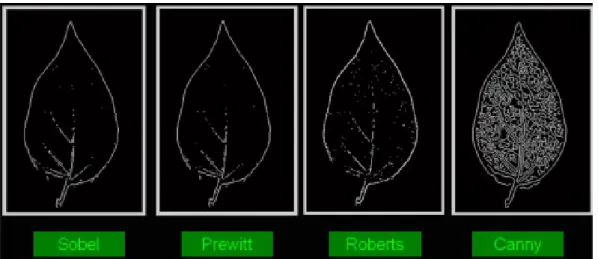
2.5 Edge detection comparison using different operators, byHusin et al.(2012). . . 21
2.6 Visualization of the SIFT descriptor computation. For each (orientation normal-ized) scale invariant region, image gradients are sampled in a regular grid and are then entered into a larger 4 × 4 grid of local gradient orientation histograms (for visibility reasons, only a 2 × 2 grid is shown here), byGrauman and Leibe(2011b). 23
2.7 The London tube map is an example of a topological map. A topological map contains less metric details and is centered in describing the main places and their connectivity. . . 25
2.8 Feature-based map vs Grid-based map. . . 27
2.9 An occupancy grid-map built by a robot using localization and mapping technique. This map was obtained at the Faculty of Engineering of the University of Porto, by a robot with ROS, Laser range finder and the Hector SLAM package. . . 29
2.10 3D representations of a tree scanned with a laser range sensor (from left to right): Point cloud, elevation map, multi-level surface map, and the volumetric (voxel) representation suggested byHornung et al.(2013). The volumetric representation explicitly models free space but for a better perception only occupied volumes are visualized. . . 30
2.11 The essential SLAM problem. A simultaneous estimate of both robot and land-mark locations is required. The true locations are never known or measured di-rectly. Observations are made between true robot and landmark locations, by
Durrant-Whyte and Bailey(2006) . . . 30
2.12 The EKF-SLAM map of features with uncertainty associated before and after the close loop, byKasra Khosoussi(2009) . . . 31
2.13 SLAM mapping using Rao-Blackwellised particle filters at four different times, byHahnel and Burgard(2003) . . . 32
2.14 Xica Robot at Robot@factory field. This robot has one Laser Range Finder, one webcam and four distance sensors. . . 33
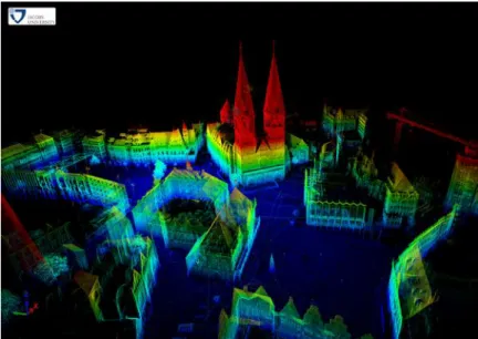
2.15 A 3D map of Bremen city obtained using the 6D SLAM, available at3DTKSite
(2013) . . . 35
3.1 How will the robot associate the human words to the correct object and/or place or action? . . . 38
3.2 System overview from Nüchter and Hertzberg (2008): From left to right: 6D SLAM acquires and registers a point cloud consisting of multiple 3D scans; then there is a scene interpretation which labels the basic elements in the scene; after that object detection locates previously learned objects in 6 DoF, and finally the semantic map is presented to the user. . . 39
3.3 The spatial and semantic information hierarchies, by Galindo et al.(2005). On the left, spatial information gathered by the robot sensors. On the right, seman-tic information that models concepts in the domain and relations between them. Anchoring is used to establish the basic links between the two hierarchies (solid lines). Additional links can then be inferred by symbolic reasoning (dotted line). 41
3.4 Multi-layered representation defined byZender et al.(2007) . . . 42
3.5 The layered structure of the spatial representation and the visualization of an ex-cerpt of the ontology of the conceptual layer. The conceptual layer comprises knowledge about concepts (rectangles), relations between those concepts and in-stances of spatial entities (ellipses). ByPronobis(2011). . . 43
3.6 Pronobis and Jensfelt (2012) depicts the structure of the system and data flow between its main components. . . 44
3.7 HySeLAM - Hybrid Semantic Localization and Mapping. HySeLAM is a seman-tic extension to classical SLAM, divided in two layers: topological and objects. The topological layer stores the place properties and place connectivity in the topo-logical map. The objects mapping layer stores the relation between objects and between objects and places in the object map. OST - Object segmentation and tracking runs a process for object segmentation and tracking. OST manages an Object dictionary. . . 46
3.8 The Augmented Topological map defines a place according to its delimitation and visual gist. The edges/arcs define the connection between places and are labeled by doorways. . . 47
3.9 The topological engine has seven components: TopoParser, TopoMerge, Place-Man, TopoVisualSignatures, TopoState, Topofeatures and Gr2To. . . 49
3.10 The objects map relating Object/place spatially. Each object is an instance of a generic object described in Object dictionary. The places are represented by rectangular symbols and objects are represented by circular symbols. . . 51
3.11 The objects mapping engine has four components: TextParser, NewObject, FillMap, and ObjectDetector . . . 52
4.1 How do humans do place segmentation from a gridmap? . . . 57
4.2 The Vonoroi diagram (red) for this gridmap was obtained using the Dynamic Voronoi algorithm described in Lau et al. (2010). The grid map was obtained with RobVigil and Hector SLAM in the first floor of the building I of the Faculty of Engineering of the University of Porto. . . 58
4.3 Two approaches for door detection. From left to right: Real environment, Occu-pancy gridmap with virtual doors detected by the approach ofChoi et al.(2009), and Occupancy gridmap with Virtual doors detected by the approach ofJoo et al.
(2010) . . . 59
4.4 The Gr2To algorithm extracts the augmented topological map from an 3D occu-pation gridmap using five main stages. . . 60
4.5 The 3D grid map obtained by the RobVigilPinto et al.(2013a). The red points are occupied cells that are higher than 1.80 meters. The white points are occupied cells that are bellow. This map was obtained in the first floor of the building I of Engineering Faculty From Porto University. . . 61
4.6 The top 2D grid map was obtained in the first stage of Gr2To using the 3D map, figure 4.5. The bottom 2D grid map is a map obtained using a 2D SLAM with the acquisition system at 1.20 meters from the floor. The top map has filtered the furniture present in the bottom grid map. (First floor, building I, FEUP ) . . . 62
4.7 Red circles are places with higher probability of door existence and they were identified by the door detection algorithm. Blue lines represent the door in a closed state. On the left corner, the principle for door searching represented if the blue cell and the red cells satisfy the requirements then the blue cell is considered to have higher probability of door existence. (First floor, building I, FEUP ) . . . . 63
4.8 The obtained Voronoi graph diagram with nodes and edges numbered. The squares represents the nodes.(First floor, building I, FEUP ) . . . 65
4.9 This is the intermediate topological map obtained in the fourth stage. The red circles represent the main places (vertices), the cyan circles represent the location of the doors, and the black lines represent the connection between the main places. The yellow circles are the critical points. The green lines are a boundary defined by the critical points. (First floor, building I, FEUP ) . . . 66
4.10 Segmented places over the grid map identified with random colors. (First floor, building I, FEUP ) . . . 67
4.11 Result obtained with the gridmap of the TRACLabs facility, available in Ko-rtenkamp(2012). In the left map, Gr2To has marked with red circles locations with higher probability of door existence. In the right top map, Gr2To draws red circles in the identified places, cyan circles in critical points with high probability for of door existence and black lines the connectivity between vertex. In the right bottom map, Gr2To draws places delimitation with random colors. . . 68
4.12 Intermediate steps and final place segmentation done by Gr2To with grid map obtained from virtual scenario. . . 69
4.13 The intermediate steps and final place segmentation done by Gr2To with the oc-cupancy grid map obtained by DP-SLAM, in SDR, on the site B of University of Southern California. . . 70
4.14 The intermediate steps and final place segmentation done by Gr2To with the oc-cupancy grid map obtained by DP-SLAM inside the Intel Research Lab in Seattle. 71
5.1 Translating the place description given by a human into an augmented topological map and merging this map with the robot’s internal knowledge. . . 77
5.2 Speech recognition and natural language processing for graph extraction. . . 79
5.3 Rule-based generation of ancient roman houses, with the outside appearance on the left, and the interior facade on the right. ByAdão et al.(2012) . . . 79
5.4 Grammar example with defined sequences of texts and annotations for the recog-nition area, which are used on the recursive method calling the grammar itself. . . 80
5.5 Nooj output file for the description of the place used in the testing scenario. . . . 81
5.6 The graph matching problem. . . 84
5.7 Merging map illustrations: Mt represents the topological map obtained from the grid-map and Ghuman represents the topological map obtained from the natural language (human). The red arrow is the partial a priori knowledge inferred from the human interaction and it is a constraint that simplifies the matching problem. 88
5.8 The matching matrix Hmatch of the TopoMerg library and the solution explorer. The red cell represents the constraint of the solution. . . 90
5.9 Edge matching matrix stores the edge connections of Mwand Ghuman. . . 92 5.10 From left to right, the gridmap obtained from hector slam in a virtual scenario , the
space segmentation obtained from the Gr2To, and the topological map extracted from the Gr2To. . . 94
5.11 The best matching matrix Hmatchbest for the two topological map obtained from the human description and from the Gr2To. . . 94
5.12 The results obtained from the fitness function, for all possible combinations, dis-cretized into 1000 slices from 0 to 1 . . . 96
5.13 The evolution of matching quantification during construction of the solution, by the TopoMerg algorithm. . . 99
6.1 Chang and Pei(2013) suggest a new algorithm to achieve color constancy. From left to right: the original input images (with different illuminants); after the re-sults obtained from Max-RGB (proposed by Land and McCann(1971)); GGW, based on the gray world hypothesis (proposed by Van De Weijer et al. (2007)); GE1, based on the gray edge hypothesis (also proposed byVan De Weijer et al.
(2007)); the local space average color (LSAC) (proposed byEbner(2009)); and the chromaticity neutralization process (proposed byChang and Pei(2013)). . . 106
6.2 An example of the global image/scene descriptor extractor using the concepts of “bag-of-features” and “codebook“. The global descriptor can be defined as a his-togram of occurrences of the discretized descriptor space. . . 107
6.3 Lazebnik et al.(2006) give an example of constructing a three-level pyramid. The image has three feature types, indicated by circles, diamonds, and crosses. At the top, Lazebnik et al. (2006) subdivide the image at three different levels of resolution. Next, for each level of resolution and each channel, they count the features that fall into each spatial bin. . . 109
6.4 Cao et al.(2010) propose two spatial bag-of-features approaches. This image gives an example for the construction of linear and circular ordered bag-of-features. Stars, triangles, and circles represent three kinds of features. (a) Linear projection: all features are projected onto a line with angle θ and resolution L = 4, and then the features within each spatial bin are counted. (b) Circular projection: we locate the center at (x; y) and evenly divide the space into L = 8 sectors, and then count features within each sector. . . 110
6.5 In BoW, each document is a bag of words, as it assumes that word order has no significance (the term “car drive” has the same probability as “drive car“). On the other hand, in pLSA, a larger corpus is considered instead of a single document, to infer more meaningful conclusions. In pLSA, the latent concepts (or topics), denoted as Z, act as a bottleneck variable. . . 113
6.6 Pham et al.(2010) show an example of a visual graph extracted from an image. Concepts are represented by nodes and spatial relations are expressed by directed arcs. Nodes and links are weighted by the number of times they appear in the image.114
6.7 Architecture of the multi-modal place classification system, by Pronobis et al.
(2009). . . 117
6.8 This image illustrates the maximum-margin hyperplane (red line) and margins (blue dash lines) for an SVM trained with samples from the two classes. Samples on the margin (red circles) are called “support vectors”. . . 120
6.9 This image illustrates the LBP8,1. Using a code, the LBP operator describes the pattern around a central pixel. To obtain this code, the image is converted to a gray scale image and the central pixel is compared to the neighbor pixels. This comparison results in a binary value of “0” if the central pixel has a higher intensity value, or “1” if the central pixel has a lower intensity value. . . 122
6.10 The LBPbyHSV approach clusters the LBP histogram into n basic colors. Then the LBP label and the basic color of the central pixel are extracted from each image pixel, which then increments the bin related to the LBP label in the color set bin related to the central pixel. . . 124
6.11 Semantic localization provided by the LBPbyHSV approach. The semantic local-ization provided by the HySeLAM (groundtruth) is in blue, the semantic localiza-tion provided by the LBPbyHSV-U16S with SVM (Linear kernel) is presented in red. . . 128
6.12 This image shows two frames from the Freiburg university path. These images be-long to the set of non-descriptive images that reduce the accuracy of the classifier. As the reader can see, these images do not include enough features for the place they belong to to be detected. . . 129
6.13 This image shows four frames from the Ljubljana path. These images are from the fuzzy/gray zone, where it is hard to tell if they are acquired from the Ljubljana WC or the Ljubljana corridor. . . 130
6.14 This figure illustrates a Markov chains representation (for the motion process) over an augmented topological map. The green edges represent the activated state transition edges that are built from the original place connections (in blue). The state probability and a self transition edge are included in each vertex. Each edge is labeled with the state transition probability value. . . 137
6.15 Confusion matrices obtained for the pair LBPbyHSV-U8N-IRIS and polynomial kernel. Top left: confusion matrix for the place recognition procedure without any filter. Top right: the confusion matrix for the place recognition procedure with a simpler filter. Bottom: the confusion matrix for the place recognition procedure with a Markov chain based filter. . . 140
6.16 On the top, two image frames from the COLD dataset, with LBPbyHSV-U8N-IRIS, using a static point in the middle of the image for image splitting. On the bottom, the illustration of the same frames with the central point placed on the vanish point. . . 141
7.1 The robot entity is decomposed into five blocks: Mission, Planner and supervisor; Action; Sensing and knowledge storage; Interaction and abstract knowledge; and Physical entity. . . 146
7.2 The Produtech Robot is an autonomous mobile platform. This platform was built with two freewheels and one traction directional wheel. The main sensors are two SICK laser range finders (2D). The main computer is installed with Ubuntu (Linux SO) and ROS (Robotic operating system). . . 148
7.3 The HySeLAM extension integrated with Hector SLAM. . . 149
7.4 Interacting with the robot using the Gtalk messenger service from google. This version of the HyGtalk replies always with the received sentence and answer of the robot. . . 150
7.5 Glass wall detector based on human description. Four tests are shown. The robot is represented by a red circle with the blue line representing the robot orientation. The searched area is marked with green color. The detected corners are repre-sented by red squares and the estimation of the glass wall position is reprerepre-sented by a blue line. . . 151
7.6 Convex corner detector. . . 151
7.7 At the left the map of the first floor of the building at right the occupancy grid-map obtained by the robot through the Hector SLAM. . . 153
7.8 The four moments when the human tells the robot about the existence of a glass wall. The red spots are the corners detected, the area searched is in green and the blue line is the estimated location of the glass wall. . . 155
7.9 The augmented topological map obtained from the Gr2To algorithm, shown by the HySeLAM Graphical interface. Each place is identified by a unique code word. The group of places that can represent a single place (and a corridor) are tagged with a code word starting with CC; the other places are tagged with a code word starting with SS. . . 156
7.10 The augmented topological map merged with the description of the place provided by the human. The vertex with green borders represents places without associated human words; the vertices with blue borders are places with associated human words that were confirmed; and the vertex with red borders are places with asso-ciated human words which were not confirmed. . . 157
7.11 The Logitech QuickCam attached to 9DOF Razor IMU . . . 159
7.12 In first two rows, images used during the learning stage are shown. Last row, images with people that were correctly classified with hLBP visual signature. . . 160
7.13 Confusion matrix comparison. On top the confusion matrices obtained for the hLBP+[ψ]+A20approach, on the bottom, confusion matrices obtained for the for sLBP-(S)LRFn+[ψ] approach. At the left there is the classifier without Markov filter, at the right with Markov filter. These classifiers were using a linear kernel. 163
Introduction
The main motivation behind this work is the belief that robots can make an important contribu-tion to the future of our society. Instead of having robots that work in high-tech factories with preprogrammed tasks, we are going to have robots that work and cooperate alongside us.
In the last three decades we succeeded in developing robots that execute a limited set of tasks with precision in a repetitive and continuous manner. These robots are mainly used in high-tech factories for massive production. Such robotic automation has freed humans from heavy and tedious labor. However, if we take one of those robots and place it in our homes, offices, public spaces or even in small factories, it becomes inefficient or usefulness. Three reasons for this are:
• These robots were developed to work in a structured and controlled environment. Simple light variations or artificial landmarks missing can make them inoperative or malfunction-ing.
• The set of tasks of these robots is limited and preprogrammed. These robots do not have the capacity to learn a new task from a human demonstration or human description.
• These robots can only accept a limited set of commands that are only known to a pro-fessional user. These robots can not acquire or share information from voice interaction, gestures or natural textual interaction.
With this in mind and knowing that the new generation of robots is going to interact with humans and work and live in our homes, offices, public spaces and small factories, new capabilities must be developed for them. Georges Giralt, in the book edited bySiciliano and Khatib(2008), emphasized four general characteristics these robots need:
• they may be operated by a nonprofessional user;
• they may be designed to share high-level decision making with the human user;
• they may include a link to environment devices and machine appendages, remote systems, and operators;
• the shared decisional autonomy concept (co-autonomy) implied here unfolds into a large set of cutting-edge research issues and ethical problems.
Rodney Brooks, also inSiciliano and Khatib(2008), describe these robot capabilities in terms of the age at which a child has equivalent capabilities:
• the object-recognition capabilities of a 2-year-old child; • the language capabilities of a 4-year-old child;
• the manual dexterity of a 6-year-old child; and, • the social understanding of an 8-year-old child.
Teresa Escrig, inEscrig, describes five features for these new robots that should be worked on and improved:
• Perception – “ not only taking data from the environment, but transforming it into knowledge (and even wisdom) to be able to interpret and modify its behavior according to a result of this perception.“
• Reasoning – “drawing conclusions from data/knowledge taken from perception.“
• Learning - “ with new experiences, the robot needs to perceive and reason to obtain con-clusions, but when the experiences are repeated, a learning process is required to store knowledge and speed up the process of intelligent response.“
• “ Decision Making, or the ability to prioritize actions, is necessary to be able to be safe and effective in the solution of different autonomous applications.“
• “ Human-Robot Interaction at many levels is also necessary. For example, natural language processing: understanding the meaning of sentences exchanged with humans, depending on the context and to be able to properly respond, and emotions rapport.“
This new generation of robots introduces not only the critical issue of human-robot interaction to the scientific community, but also the front-line topics encompassing cognitive aspects: user-tunable human-machine intelligent interfaces, perception (scene analysis, category identification), open-ended learning (understanding the universe of action), skills acquisition, extensive robot-world data processing, decisional autonomy, and dependability (safety, reliability, communication, and operating robustness).
1.1
Global Overview
Rhino byBurgard et al.(1999), figure1.1, was a pioneer attempt to take a robot to a public space for human interaction. Rhino had been built to assist and entertain people in public places, such as museums. In May 1997, Rhino was deployed in the “Deutsches Museum Bonn“. During a
six-day installation period the robot gave tours to more than 2,000 visitors. Burgard et al.(1999) reported a situation where more than a hundred people surrounded the robot from all sides, making it difficult for the robot to reach the exhibits as planned while not losing track of its orientation. Also, they reported that ”some of the users were not at all cooperative with the robot, imposing further difficulties for the software design. Often museum visitors tried to ”challenge” the robot. For example, by permanently blocking its way, they sometimes sought to make the robot leave the designated exhibition area towards other parts of the museum, where several unmapped and undetectable hazards existed ( including a staircase).“ The experiments with Rhino were useful to learn that we cannot necessarily expect humans to be cooperative with robots, so the safety of the system may not depend on specific behavioral requirements on the side of the users. On the other hand, people are thrilled if robots interact with them just like they are if people interact with them. Another important result from these experiments was the results of the interview made to museum visitors where most of them assigned more weight to the robot’s interactive capabilities than to its ability to navigate
Figure 1.1: From left to right: the Rhino robot, byBurgard et al.(1999), Robox robot, bySiegwart et al.(2003), Jinny robot, byKim et al.(2004).
After Rhino, we found several other similar robots in literature which were deployed in public spaces for human interaction, as Minerva byThrun et al.(2000), Robox bySiegwart et al.(2003), Mobot byNourbakhsh et al.(2003), and JinnyKim et al.(2004). These robots rely on 2D accurate metric representations of the environment, derived from simultaneous localization and mapping (SLAM) techniques. They are developed to be reactive and they cannot acquire any knowledge from human interaction. They have quite limited communication capabilities and they can not interact with objects present in the environment.
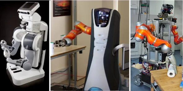
The interaction with objects present in the environment is a demand for these robots to be useful as personal assistants. With this in mind, the Willow Garage company developed a new robot called PR2, figure1.2. Comparing this robot to previous ones, regarding physicality, PR2
is augmented with two arms and a stereo vision system. PR2 is a research platform and it was created to help boost several research topics, as grasping/manipulation, human-robot interaction, motion planning, perception, and task planning. Bohren et al. (2011) report several experiences and results while they were building an autonomous robotic assistant using the PR2 platform and ROS 1. This robot was developed for a particular application for a personal robot: fetching and serving drinks.
Figure 1.2: From left to right: PR2 robot, byBohren et al. (2011), Care-o-bot Robot byReiser et al.(2009), TUM-Rosie robot, byBeetz et al.(2009).
Developing a new robot requires the integration of many complex subsystems, as perception, motion planning, reasoning, navigation, and grasping.Bohren et al.(2011) noticed that even with an extensively validation process for each of these individual components, the subsequent step of integrating them into a robust heterogeneous system is a hard task which is not solved yet. Even so, they have successfully assembled a personal robot for fetching and serving drinks. However, this robot was developed with preprogrammed object detection tasks and with predefined actions. For example, the action to take a drink from the fridge was developed by the programmers for a specific fridge and bottle drink. This robot has not learned this action from a human demonstration. If the robot is deployed in a home that has a different fridge and bottle drink it will probably fail in the action, as it does not have the capacity to relearn or adapt the action.
Other similar robots that were developed to interact with objects are found in literature, as Care-o-bot by Reiser et al. (2009), TUM-Rosie byBeetz et al. (2009), and Herb by Srinivasa et al.(2009). When compared to Rhino, these robots are one step forward, being able to perform mobile pick-and-place tasks and even fold towels or prepare meals. However, performing human-scale manipulation tasks in dynamic environments, like a household, nursing home or even in 1ROS is an open source Robotic Operating System which was originally developed in 2007 under the name Switch-yard by the Stanford Artificial Intelligence Laboratory. As of 2008, development continues primarily at Willow Garage, a robotics research institute. Today, this software initiative is supported by an international community of robotics re-searchers and managed by Open Source Robotics Foundation –http://www.ros.org
some small factories, remains very challenging because robots often do not have the knowledge to perform them the right way. The main reason is that the robot actions and object perceptions remain static even when it interacts with a human or sees the human doing the same action in the right way.
A personal robot assistant should have several processes related to attention, memory, lan-guage production and understanding, learning, reasoning, problem solving, and decision making. This means that these robots should have some degree of cognitive capacity. Thus, the iCub robot was developed, figure1.3, to promote a collaborative and multi-disciplinary initiative in artificial cognitive systems. Sandini et al. (2007) describes this robot as an open-systems 53 degree-of-freedom cognitive humanoid robot, 94 cm tall, equivalent to a three year-old child. This robot is able to crawl on all fours and sit up, its hands allow dexterous manipulation, and its head and eyes are fully articulated. Also, it has visual, vestibular, auditory, and haptic sensory capabilities.
Figure 1.3: From left to right: Icub, Nao, Asimo and Ecce
Tikhanoff et al.(2011) reports several simulated experiments showing that the iCub robot is able to learn to handle and manipulate objects autonomously, to understand basic instructions, and to adapt its abilities to changes in internal and environmental conditions.
Broz et al.(2009) explores a system for the learning of behavior sequences based on rewards arising from social cues, allowing the iCub to engage a human participant in a social interaction game. In their work they reported that gaze is a powerful social cue, and it is also one that becomes socially significant at an early developmental stage; even young infants are responsive to other’s gaze direction.
Figueira et al.(2009) reports a new technique where the iCub learns autonomously new objects from the environment. The objects are defined as clusters of SIFT2visual features. When the robot 2SIFT stands for Scale-Invariant Feature Transform and it is an algorithm in computer vision to detect and describe local features in images. The algorithm was published by David Lowe in 1999 and it is commonly used for object recognition, robotic mapping and navigation, image stitching, 3D modeling, gesture recognition, video tracking.
first encounters an unknown object, it stores a cluster of the features present within a distance interval, using depth perception. Whenever a previously stored object crosses the robot’s field of view again, it is recognized, mapped into an egocentric frame of reference, and gazed at.
Miihlig et al. (2010) reports a new robot control and learning framework, applied to the ASIMO robot, figure1.3. With this new framework the robot was able to learn an invariant and generic movement representation from a human tutor, and even to adapt this generic movement to a new situation.
In literature we found other similar robots that were used to developed cognitive capacity, as the Nao robot developed by Aldebaran Robotics company, and ECCEROBOT (Embodied Cog-nition in a Compliantly Engineered Robot) developed under the 7th framework program of the European Union. These robots, figure1.3, are a step forward but faraway from the robot capabili-ties described by Rodney Brooks. Object-recognition, language and manual dexterity capabilicapabili-ties are still a challenge, as correct world knowledge representation and learning process are also open fields for research in the next decade. As reported by Bohren et al. (2011), even when a good approach to one of this problems is found the integration with the other robot components is also a challenge.
1.2
Research questions
This work evolves from previous research works in robotics, mainly in navigation, localization and field mapping. In the last two decades these three fields were intensively explored and nowa-days there are valuable solutions making it possible for robots to navigate and explore a building autonomously. The main contributions were novel SLAM approaches based on laser range finders and techniques derived from Bayes’s rules, as described in the section 2.4. Nerveless, there are still some open issues related to localization and field mapping, such as:
• How to validate the location estimation obtained from a SLAM approach?
When the robot is placed in an unknown place of a symmetrical building most SLAM ap-proaches which do not use artificial landmarks may converge to a solution that may not be the correct one. With a more robust SLAM approach to the scenario, better sensors and optimized trajectories, the correct solution may be reached but it will take more time than a human does and it will be less efficient because it requires more movements from the robot. This happens because these algorithms rely on geometric information and/or in rudimentary visual features as the ones used by SIFT and SURF algorithms.
• How to detect a Kidnapping situation or recover from it?
Kidnapping is one of the hardest problems to solve in the field of SLAM. Kidnapping a robot refers to the act of picking up a robot in the middle of its operation and place it somewhere else in the environment, without notifying it. It is similar to knocking a human over the head in order to make it unconscious, and moving them to some other location in
the building. Even if the new location is geometrically identical to the previous one, the human will recover because they can use natural features and reason in order to detect that something is wrong. In our knowledge, there is not a robotic approach as efficient as the human mechanisms because most SLAM approaches rely on geometric information or on rudimentary visual features as the ones used by SIFT and SURF algorithms.
• How to detect if the associated features are the correct ones?
The robustness and accuracy of any SLAM approach depends on the correct association of obtained measurement and stored feature. Most SLAM approaches rely on rudimen-tary geometric or visual features which are sometimes associated to furniture present in the environment. If someone moves the furniture these features will get a new location, thus af-fecting localization estimation negatively. Most SLAM approaches will recover and update the feature location. However, during this time, there is an increase in the uncertainty of the estimation as well as in the risk of localization failure. The knowledge of features that are good or more reliable will help solve this problem. For that, information is needed about what belongs to the features during mapping and localization, but this requires a higher level of knowledge.
• How to make this knowledge sharable to other kind of robots?
When we have a team of heterogeneous robots, the map acquired by one robot (using a SLAM approach) is not always easily transferable to others robots. This happens because these robots have different sensors, each robot has its own sensor configuration, each robot has an acquired map with its own referential of observation, the robot sensors cannot observe the same features as the other robots, and each robot can have its own map representation. In our point of view, the best approaches to solve this issue are those that translate this map to a higher level of representation, as topological or semantic maps. The higher level of representation makes it possible to abstract the low-level features and to share to other robots a description about the ways the place is organized. This description can be used later to help the robot build its own low-level map. Also, this common description can be useful to describe tasks for the robots in the same framework and it can be useful in the validation of maps.
As said before, I believe that there will be robots which will work and cooperate alongside us. So, robots will work in a place organized by humans, executing tasks described by humans. With these assumptions, we can tackle the previous questions considering human knowledge input in the mapping and localization process. However, this leads us to our fundamental research question:
• How can a SLAM approach be extended in order to include the human into the map-ping process?
The robots that will work alongside us should have a perception of the world that is com-patible to ours, because they are going to manipulate objects and places that are structured
by humans. So, object interaction, perception and manipulation as well as strong com-munication abilities are required for the next generation of robots. To make this possible, we will need to extend geometric and/or topological based mapping and localization to se-mantic mapping and to build a common cognitive workspace, as suggested byDellaert and Bruemmer(2004).
1.3
Main contributions
This work was driven by the fundamental research question How can a SLAM approach be ex-tended in order to include the human into the mapping process?. But also taking in mind that the answer should help to solve the remain open questions in SLAM, enable the robot to under-stand human descriptions about the places and objects and to reason about the acquired knowledge through a SLAM approach.
During the construction of my approach to answer this question, the following contributions to the scientific community were carried out:
1. A new semantic extension to SLAM.
In this thesis a novel semantic extension framework for SLAM approaches based on gridmaps was formalized. The name of this framework is HySeLAM, which stands for Hybrid Se-mantic Localization and MApping. This framework formalizes two layers connected to the SLAM approach in order to describe places and objects and the relation between them.
2. An approach to convert a grid-map into an augmented topological map.
In order to connect the grid-map to augmented topological map, it was required to formalize an approach to discretize a grid-map into this topological map. This approach was imple-mented with the name Gr2To, which stands for gridmap to topological map tool. This tool abstracts the gridmap with delimited places and the connectivity between places
3. A formal strategy that answer to the question “how to merge a place description given by a human into the augmentation topological map”.
The obtained topological map from Gr2To is not completed and was not validated by a human. To solve an approach to merge a description given by a human into the internal augmented topological map was formalized. This approach was implemented with the name TopoMerg, which stands for topological merging tool.
4. An approach for visual place recognition, based on a new global descriptor and filtered by a Markov chain.
In order to get a redundant approach for the conventional SLAM approach, a visual place recognition is proposed. This approach localizes the robot on the augmented topological map. Two main contributions were made in this topic: a new global descriptor based on
local binary patterns operator was proposed, and a new filter based on Markov chain was proposed to constrain the classifier probabilities to flow according the topological map.
1.4
Structure of this Thesis
In synthesis, the primary aim of this work is to address the problem of discovering and incorpo-rating higher level structures into the maps generated by SLAM approaches in order to make this knowledge sharable to humans in a voice channel. In this introduction, the motivation for this work has been presented in the context of an overview of the existing literature, and each chapter presents a more detailed review of specifically related work.
The document is structured as follows :
• Chapter 2makes a categorization of input information of the robot, an exhaustive review about basis and foundations in the topic of SLAM and a review about spatial knowledge representations. To create an internal knowledge about the world, the robot requires infor-mation provided by internal/external sensors and inforinfor-mation provided by communication channels. In this work the most common sensors are categorized along with the way this in-formation can be preprocessed and used to create knowledge about the world. An exhaustive review of different approaches to SLAM was carried out to make it possible to characterize how the world is stored and represented in the most common SLAM approaches. This will lead to an answer to the question of how to extend this to other kinds of representation. Finally, different approaches for spatial knowledge representation are also shown, namely grid maps and topological, semantic and hybrid maps.
• Chapter 3addresses the fundamental question: How to make the robot knowledge closer to the human description. Section3.1presents the literature review related to the fundamental question, and section3.2details the proposed approach for semantic mapping, called Hybrid localization and mapping (HySeLAM).
• Chapter 4 presents a novel approach that translates a grid map, which was obtained from SLAM, into an augmented topological map defined by the HySeLAM framework. This approach is capable of translating a 3D grid map into an augmented topological map. It was optimized to obtain similar results to those obtained when performed by a human. Also, a novel feature of this approach is the augmentation of the topological map with features such as walls and doors. Section4.1presents a global overview of the problem and different approaches to translate a grid map into a topological map. Section4.2 presents the novel approach to translate a grid map into a topological map. Section4.3 presents the results obtained using this novel approach. Section4.4presents the chapter conclusions and future directions.
• Chapter 5addresses these two fundamental questions: How can a place description given by a human be translated into an augmented topological map?and How can two augmented
topological maps be merged into a single one?. Section5.1presents a global overview of the problem and our approach to translating a place description given by a human into an augmented topological map. Section5.2presents a global overview of the graph matching problem. Section5.3presents our approach to merging the two topological maps obtained from a human description and an occupancy grid-map. These topological maps have a graph structure, so the merging problem results in a graph matching problem with constrains. The proposed approach to merging these graphs was developed based on the graph matching theory and recurring to tree search concepts.
• Chapter 6addresses two questions: How must the visual signatures be constructed to al-low for robust visual place recognition and classification? and How can the augmented topological map be included in the semantic localization procedure for increased place recognition accuracy?. Section 6.3proposes the LBPbyHSV approach for the global de-scriptor extraction and compares the performance of this global dede-scriptor against local and global descriptors for indoor place recognition. Section6.4proposes an approach based on Markov Chains formulation to answer the second question for this chapter.
• Chapter 7presents the implementation of this HySeLAM framework into a real robot. The tests are described and results are shown.
• Chapter 8presents the final discussion, the conclusions obtained from this work and future work directions.
Background: How a robot sees the
world
Cooperation between robot and humans creates the challenge of discovering and incorporating higher level structures into the information processed and stored by robots. To solve this challenge and to answer to the fundamental question of this work ( How can a SLAM approach be extended in order to include the human into the mapping process? ) one must know how the robot acquires information about the world and about itself and also how this information is processed and stored. The understanding of all these robotic processes (acquisition, processing and storing) involves several fields of knowledge, which are well detailed in the handbook of robotics edited bySiciliano and Khatib(2008).
The aim of this chapter is to give a brief overview about six essential topics, which are: local-ization, motion sensing, perception sensors, imaging processing, maps, and methodologies used for the simultaneous localization and mapping problem. They are important because they were essential to draw the proposed approach which answers to the fundamental question. This chapter is organized into four sections, as follow:
• Section 2.1 presents three kinds of information gathered by the robot: self motion, local-ization and perception raw data provided by the most common perception sensors. Un-derstanding how this information is gathered and processed is important because one of the most interesting capacity of the robots over the humans is the high accuracy, precision and repeatability observed during their task execution. These are possible due the accu-racy of the observations made by some sensors and the strong math formulation used for processing this information. Understanding how self motion and localization are gathered and processed mandatory in order to extend the robot capabilities without losing its inherent high accuracy, precision and repeatability.
• Section 2.2 presents a brief overview of the techniques used in image processing in order to show how complex this task is and to what kind of information can be extracted from the vision system. These vision systems are considered important for robotics because they
make it possible for the robots to observe the same things as humans do. This observation makes it possible to for the robots to gather the same references as humans do, which is important vital when a cooperation between robot and humans is required.
• Section2.3presents an overview about two different kind of maps used in robotics, topolog-ical and metric maps and how these maps are used. This is the primitive knowledge stored by the robot and it is the primitive knowledge to which the semantic mapping should be referred.
• Section2.4presents several approaches used in the simultaneous localization and mapping process. With these approaches the robot can “learn” the environment structure (through motion exploration) and they can estimate the robot location, based on the apprehended knowledge and sensor observations. As mentioned earlier, in chapter 1, these SLAM ap-proaches will be the starting point for the semantic mapping process.
2.1
Motion, Localization and Perception Sensors
A global overview about the type of information gathered by robot sensors is useful to under-stand the relationship between information gathered from robot-human interaction and informa-tion gathered from robot sensors. This input informainforma-tion gathered by a robot can be classified into four main classes: self-motion information, localization information, world perception and interaction information. However, only the first three are described.
2.1.1 Self-motion information
Self-motion information is a class of information that describes the motion of a referential frame attached to a point of the robot. This information is gathered from processed readings obtained from motion sensors and encodes with values the magnitude of referential motion derivatives as: linear velocities and accelerations and angular velocities and accelerations. These derivatives are usually integrated and projected into another referential frame, in order to describe the robot motion or robot part motion. This motion can be described in one, two or three dimensions.
To this triplet motion sensor, processing and integration is usually denominated as dead reck-oning system. The advantages of dead reckreck-oning systems are the higher update rates and the independence of external sensors; it is a stand-alone system. The main disadvantage is the ex-ponential degradation of accuracy over time. This happens because the estimation relies in the integration of sensor readings which are always affected by noise. To eliminate this disadvantage, the estimations of a dead reckoning system are usually fused to other systems using the Kalman filter theory, described byKalman(1960).
The most widely used dead reckoning system is odometry. Odometry is a system that observes the rotation of one or more robot wheels and projects this rotation to linear and angular velocities, which are used to estimate the system motion.Borenstein et al.(1996) describes several methods
to project and to integrate this observation. Odometry provides good short-term accuracy, is inex-pensive, and allows very high sampling rates. However, as dead reckoning system, the inaccuracy in pose estimation increases over time, and it is worse when there are mechanic imperfections, different radius of wheels and poor calibration of odometry. Borenstein and L.Fen(1996) have detailed and classified the main sources of errors in the odometry system.
Inspired by odometry, several researchers have replaced the sensors attached to the wheels by cameras. This technique is usually called visual odometry. “Visual odometry” was coined in 2004 byNistér et al.(2004). Basically, the visual odometry approach takes two calibrated and successive images, then it extracts features from them and associates features from both images. From this features association it is possible to construct an optical flow field which is used to estimate the camera motion. This approach eliminates the mechanical errors of odometry systems but is extremely heavy in terms of processors usage and its accuracy depends on the quality and number of features extracted from the images. Maimone et al.(2007) have successfully applied this technique in a Mars exploration rover in order to autonomously detect and compensate for any unforeseen slip encountered during a drive. Scaramuzza and Fraundorfer(2011) presents the last thirty years of research related to visual odometry.
With advanced microelectromechanical systems (MEMS), it was possible to build low cost and small sensors to measure linear accelerations and angular velocities. These only take mea-surements from one dimension, and they are known as accelerometers and gyroscopes sensors. Usually, three accelerometers and three gyroscopes sensors are placed in one unit. This unit is called Inertial Motion Unity (IMU). IMU are the core of the inertial navigation system (INS). INS is a system that process the measurements of an IMU in order to continuously calculate via dead reckoning approach the position, orientation, and velocity of a moving object without the need for external references. Nerveless, as this system integrates the position from a second deriva-tive, it will suffer an higher exponential accuracy degradation over time due to errors present in observations. Unsal and Demirbas(2012) improves the IMU performance by compensating the deterministic end stochastic error. Low cost INS have an acceptable accuracy in the orientation estimation.chul woo Kang and chan gook Park(2009) presents an attitude estimation method for a humanoid robot using an extended Kalman filter and one IMU. However, the accuracy of INS in the position estimation is extremely low after few seconds. For these reason, INS is usually fused to other systems.
2.1.2 Localization information
Localization information is a class of information that relates the robot position to the origin of navigation referential frame. This class of information is required by the robot for the navigation and mapping task. This information is obtained by taking distances measurements from the robot to artificial or natural landmarks and by using triangulation, trilateration or matching techniques. These systems generally have a lower update rate when compared to Dead reckoning systems, but because they are not dependent on previous measurements, the accuracy of position estimation is
not affected over time. The accuracy is only dependent on observation quality and geometry of robot and observed landmarks. This accuracy is described by a covariance matrix.
Figure 2.1: Global Positioning System (GPS) has 24 satellites in orbit. Each GPS satellite broad-casts radio signals providing their locations, status, and precise time from on-board atomic clocks. A GPS device receives the radio signals, taking their exact time of arrival, and uses these to calcu-late its distance from each satellite in view.
For outdoor robots, Global Navigation Satellite Systems (GNSS), as GPS and GLONASS, are the most common source of localization information. The theory behind a GNSS is simply that there are active beacons (satellites) emitting signals and receivers tracking these signals. In the receiver the reception and emitting time are annotated, and used to estimate the distance (pseudo-range) from the receiver to the satellites in view. These distances and satellite positions are used to estimate the receiver location, as described in Xu (2003). Deferential techniques and phase observation can be used to improve the accuracy of the system. Thrun et al.(2006) describes the Stanley robot, which has used GPS receivers to estimate the vehicle position during the DARPA Grand Challenge. The goal of this challenge was to develop an autonomous robot capable of traversing unrehearsed off-road terrain. The GPS was fundamental for the robot to know its po-sition in real time in order to navigate through the environment. Other approaches, as described by Santos(2007), based on multiple GPS receivers, can also estimate the posture of the vehicle (pitch, roll and yaw).
The localization information based on GNSS is not available in all places, as indoor sites or obstructed places, or it is very inaccurate in very dense sites, as forests or very narrow streets. For these sites, other approaches have been proposed. The Aerospace Robotics Laboratory at Stanford University has developed a prototype, a GPS-based local area positioning system, to help filling this gap. Rather than employing orbiting satellites, small low-power transmitters called pseudolites (short for “pseudosatellites”) are distributed over the place.LeMaster and Rock(2001) reports an accuracy of 0.8 meters using this approach in a Mars rover. This approach has the advantage
of using a common GPS receiver to collect the measurements and process the system position. The main disadvantage is these signals do not cross walls, which implies a high cost because several pseudolites must be used in each place delimited by walls. Usually this approach is only considered for large indoor open-spaces or to complement GNSS in outdoor places.
For indoor robots, Priyantha et al. (2000) proposes the Cricket location-support system for in-building. This approach has a low cost when compared to pseudolites and it uses the basic principle of GNSS. Instead of emitting radio-frequency signals only, this system emits ultrasound signals for the range distance measurement and radio-frequency signals for clock synchronization. There are several beacons emitting ultrasounds signals and there is the listener that listens to the messages from beacons. The listener uses the travel time of this messages to estimate distances to the beacons and then the position. There are other approaches using artificial landmarks, as the infrared spectrum approach, describe byHijikata et al.(2009) andSobreira et al.(2011), RFID by
Zhou and Shi(2009), and the visible spectrum with bar codes byLiu et al.(2010).
Some of these localization systems, based on artificial landmarks, have minimal space invasion and they are easy to install, however most of the time it is not possible to install the artificial landmarks in part or all robot environment, due to their cost or a specification that limits artificial landmarks usage. For these particular situations, other strategies were sought during the last two decades. In general, these strategies create or use a map of geometric or visual features (natural landmarks) which are used to estimate or update the robot position based on feature observations obtained from robot sensors. There are different implementation approaches, described in section
2.4, which depend on world perception sensors, detailed in section2.1.3, and which use one of the different map representations, detailed in section2.3.
2.1.3 World perception information
World perception information is a class of information that is obtained from robot sensors and which contains information about shape and color related to the surroundings of the robot.
The information acquired by the robot is always discretized in terms of space and time. So the only way to obtain the shape of the world is getting samples of 3D points, and we will refer to a collection of 3D points as a point cloud structure ℘, adopting the notation used by Rusu
(2009) . Point clouds represent the basic input data format for 3D perception systems, and provide discrete, but meaningful representations of the surrounding world. Without any loss of generality, the {xi, yi, zi} coordinates of any point pi∈ ℘ are given with respect to a fixed coordinate system, usually having its origin at the sensing device used to acquire the data. This means that each point pi represents the distance on the three defined coordinate axes from the acquisition viewpoint to the surface that the point has been sampled on.
There are many ways of measuring distances and converting them to 3D point. In the context of mobile robotic applications, the three most used approaches are: Time-of-Flight (TOF) systems, triangulation techniques, and structured light sensing devices.