Vol.45, N. 2 : pp. 137 - 149, June 2002
ISSN 1516-8913 Printed in Brazil
BRAZILIAN ARCHIVES OF
BIOLOGY AND TECHNOLOGY
A N I N T E R N A T I O N A L J O U R N A L
Arboreous Vegetation of an Alluvial Riparian Forest and
Their Soil Relations: Porto Rico Island, Paraná River, Brazil
João Batista Campos
1∗and Maria Conceição de Souza
21
Instituto Ambiental do Paraná; Av. Bento Munhoz da Rocha Neto, 16; CEP 87.030-010; Maringá - PR - Brazil.
2Universidade Estadual de Maringá/PEA; Av. Colombo 5.790; CEP 87.020-900; Maringá - PR - Brazil
ABSTRACT
The dynamics of alluvial deposits in floodplains forms islands and sandbanks. Deposits frequently accumulate at the river margins and on islands with consequent side growths. One of these sandbanks which started to form in 1952 annexed an area of 12.4ha to the Porto Rico island (53015’W and 22045’S). At present a forest fragment of approximately 2.0 ha exists in this place. The structural analysis of arboreous vegetation of this fragment showed a floristic gradient related to t he physical and chemical variations of the substratum. High density of pioneer species associated to the absence of recruitment of new individuals of these and other successional categories indicated that the forest was impaired in its succession process. This fact could be associated with constant disturbances caused by cattle in the area.
Key words: Alluvial forest, floodplain, forest structure, phytosociology, riparian vegetation, succession
∗
Author for correspondence
INTRODUCTION
After the closing of the Porto Primavera Dam in 1999, the floodplain of the high Paraná river between the backwater of Lake Itaipu, near the town of Guaira PR Brazil, and the Porto Primavera Dam SP Brazil as the only free stretch in the Paraná river in Brazilian territory. According to criteria established by Welcomme (1979) for these environments, the floodplain of the high Paraná river has its natural characteristics relatively preserved and is only slightly modified. In this stretch the Paraná river has a wide braided channel, with low declivity, sometimes with an extensive floodplain, sometimes with large islands and restricted plains (Agostinho & Zalewski, 1996). The dynamics of alluvial deposits in this
region has formed sandbanks. By the evolution and the development of the sedimentation process the sandbanks annex themselves to islands and even to the margin of rivers (welded or coalescence banks) and cause lateral growth. A colonization process of herbaceous vegetation starts on the emerging banks and may evolve into arboreous vegetation (Campos, 1999).
vegetation and its relations with soils, characteristics of the substratum of a sandbank
which started to be annexed to Porto Rico island in 1952.
Figure 1 - Location of the study area in the high Paraná river floodplain, Brazil.
The area of the forest fragment is approximately 2.0 ha, bordered by the river in front, by a communicating channel (lake) at the back and grassland at the sides, which is extensively used for cattle raising. It lies on a previous welded sandbank or coalescence that annexed itself to the Porto Rico island. Abundant arboreous vegetation developed in the area with the annexation and the evolution of the sandbank. The beginning of this sandbank has been identified by a 1952 air photograph. Some 12.4ha have been annexed to the island (Campos, 1999) (Fig. 2).
Morphology of the terrain and soil analysis
Preliminarily two distinct environments have been identified: a topographically raised margin dyke and a low area. Soil samples were collected from these two areas at three different places (1 sample and 2 replicates), for chemical and granulometric analysis. Samples from margin dyke were collected from three depths (0 –20; 20 – 100; over
100 cm); in the low area samples were collected from two depths (0 –10 and 10 - 30 cm or over), due to no variation of soil was registered from depth 10cm.
Soil classification was undertaken in small trenches and from materia l collected by hand drills. Embrapa/Iapar (1984) classification was used. Declivity of terrain was obtained by level of water in hose with graduations.
Structure analysis, distribution pattern and floristic composition of arboreous vegetation
Structure of vegetation as defined by Richards
(1940) apud Stutz de Ortega (1987), such as the
architectural organization of the forest, was evaluated by floristic diversity and phytosociology. Phytosociological survey was undertaken by division method (Müeller-Dombois
& Ellenberg, 1974), limited to an area of 4,500m2,
(100m perpendicular and 45m parallel to the river
53 30’ o
53 15’ o
CITY
CITY
PARANÁ MATO GROSSO DO SUL
23 00’ o
22 45’ o
22 45’ o
PARANÁ STATE
STATE
STATE
DIRECTION OF FLUX
ADVANCED LAB OF NUPELIA
Region of study BRAZIL
PORTO RICO
PORTO RICO
Bai a Riv
er
Para ná R
iver
Paran á Rive
r
Par aná
Riv er
Iv
in
h
e
m
a
Riv er
Iv
in
h
e
m
a
R ive r
Mutum I sland
Mut u m
Isla nd
Porto Rico
Island
N
bed) and divided into 30 samplings of 150m2 each (15m x 10m). Total area was considered a transect
so that standard distribution of species could be determined.
Figure 2 - Photo-maps of the Porto Rico island showing the start of formation of sandbank (1952) and the total area of welded sandbank in photo-map of 1965.
All individuals with CBH (circumference at breast height) equal or higher than 15 cm were sampled.
This included dead vegetation and standing and branched vegetation with at least one CBH branch.
1952
22º 45’ S
53º 15’ W
150 0 150 300 450 600 m
Scale
Para ná river
Paran á rive
r 1965
53º 15’ W 22º 45’ S
Legend 1952 ha
Forest 93,29 92,08
Sandbank in colonization 2,21 2,18
Area in colonization 5,81
5,81
5,74 Total 101,31 100,00
%
Legend 1965 ha
Forest 47,91 42,13
Welded sandbank 12.40 10.90
FITOPAC program, version 1.4, was used for phytosociological parameters. Absolute and relative density, dominance and frequency were calculated. Importance values (IV), equitability and Shannon-Weaner diversity (H’) were thus calculated (Müeller-Dombois & Ellenberg, 1974; Matteucci & Colma, 1982).
Succession stage of vegetation was evaluated by species classification in following categories: pioneer, secondary and climax, according to literature (Budowski, 1963, 1965, 1966; Denslow,
1980; Kageyama et al., 1992) and by personal
field experience.
Two phytosociological subanalysis were undertaken to evaluate influence of soil and topography in the vegetation. One comprised the margin dyke (15 samplings) and the other the low area (14 samplings). One sampling was eliminated since it laid the transition area between the two environments.
Data analysis
Detrended Correspondence Analysis (DCA) was employed to evaluate the relation between arboreous species and environment (Hill & Gauch, 1980). Ten strips parallel to the river bed, between the margin and the channel, were delimited for analysis. Each comprised three sampling measuring 15cm x 10cm. Data of IV of each species per strip were employed. PC-ORD 2.0 was used.
RESULTS AND DISCUSSION
Morphology of the terrain and soil analysis
According to Santos et al. (1992), the most common terminology to differentiate island sandbanks is the criterion of considering the level of full river margins as an arbitrary limit. Islands are structures that go beyond the full margin level. The term sandbank is used for the deposits with height lower than the above-mentioned level. The studied area surpassed the sandbank stage and in its development process annexed itself to the island. The sandbank is now part of the island. The cross section of the terrain showed a margin dyke with 2.93 m above the river level (measured on the 10-18-1996) with a declivity gradient towards the interior of the island, till it reached a higher point. Once more the declivity gradient
proceeded towards the interior of the island as far as the channel which had the same level of the river.
Morphology of terrain and difference in soil characteristics could be attributed to the deposit process of particles by the river. The current thrust deposited first the coarser material (sand) which form the sandbank on the margin dyke (and forms the a alluvial soil) and then the finer material (silt and clay) in the areas where flux speed was slower. Besides, a shallow channel was formed between the annexed sandbank and the previous margin of the island communicating with the river. Channel water was rich in suspended material, which gradually deposited in the lowest part of the sandbank. The formation of a hydromorphic soil typical of marsh areas ensued.
According to Stevaux (1994), deposits of margin dyke are restricted to a narrow strip which accompanies the channel. With regard to the low area, it has been classified by the author as an area typical of “deposits of the flooding basin” which comprises places with sediments from marsh environments, channel paleolake and sections of the floodplain immersed in normal conditions of water level.
In granulometric terms, the differences between the margin dyke and the low area were very clear. Material that characterized soils of a cruder texture (coarse and fine sand) was predominant in the margin dyke, whereas in the low area silt and clay, characterizing fine texture, were predominant. With regard to fertility, as an average, the soil of the low area was more acid and levels of
changeable aluminum (Al3+) were higher than in
the dyke area. On the other hand, it has higher values of calcium, magnesium, potassium and phosphorus, together with carbon percentage, indicating a higher quantity of organic matter (Table 1 and 2).
Table 1 - Average values and standard deviation (n = 3) of granulometric analysis of soil in the margin dyke and in the low area of the Porto Rico island, floodplain of the high Paraná river.
Place Depth (cm)
Granulometric analysis (%)
Course sand Fine sand Silt Clay
0-20 2 ± 1 68 ± 8 10 ± 5 19 ± 5
Dyke 20-100 3 ± 3 82 ± 6 03 ± 3 12 ±4
100+ 1 ± 0 50 ± 24 20 ± 15 28 ± 9
0-10 4 ± 2 33 ± 18 33 ± 12 30 ± 7
Low area 10-30+ 2 ± 1 22 ± 20 37 ± 12 39 ± 9
Table 2 - Average values and standard deviation of soil fertility analysis for margin dyke and low area in the Porto Rico island, floodplain of the high Paraná river.
Place Depht (cm)
pH meq/100ml of soil ppm %
CaCl2 H2O Al3+ H++Al3+ Ca2++Mg2+ Ca2+ K+ P C
0-20 4,6 ± 0,1 5,3 ± 1,5 0,06± 0 3,9 ± 0,4 4,7 ± 0,5 3,7 ± 0,4 0,2 ± 0 6,3 ± 2,3 10,4 ± 3,0
Dyke 20-100 4,9 ± 0,2 5,7 ± 0,4 0,03 ± 0 2,5 ± 0,4 2,7 ± 1,0 2,2 ± 0,8 0,0 5,0 ± 0 7,1 ± 0,8
100+ 4,4 ± 0,2 5,4 ± 0,1 0,17±0,1 4,2 ± 1,4 3,9 ± 1,0 3,0± 1,1 0,0 4,0± 0 7,2 ± 0,7
Low 0-10 4,4 ± 0,2 5,2 ± 0,5 0,8 ± 0,7 5,6 ± 1,5 8,8 ± 3,9 6,8 ± 2.8 0,3 ± 0,2 9,6 ± 4,7 22,4 ± 6,7
area 10-30+ 4,3 ± 0,2 5,1 ± 0,2 0,9 ± 0,6 6,0 ± 0,3 6,3 ± 1,5 5,0 ± 1,4 0,1 ± 0 4,3 ± 1,2 13,2± 2,7
According to Embrapa/Iapar (1984), alluvial soils are poorly developed soils, derived from non-consolidated alluvial sediments, without pedogenetic relation between layers and granulometry, with great variations in chemical and minerological composition. Hydromorphic Glazed soils are badly drained soils in which zone characteristics determined by climate and vegetation don’t develop entirely owing to restrictions imposed by the great influence of water in the soil and periodic flooding, always conditioned by relief and material. The soils in the studied area are very different in texture and fertility with specific characteristics in each environment.
The great diversity in environments, characteristic of the floodplain, is associated with the physical and chemical variety of the deposited material and with the interaction of relief forms and the river’s hydrological regime (Soares & Perez Filho, 1997). Differentiation of environments is the chief cause of floristic diversity (Montovani, 1989).
In studies on vegetation of the middle Paraná river undertaken by Neiff (1986) and in the high Paraná river by Campos et al. (2000), it has been suggested that vegetation is influenced by the water and sediment regime and by geomorphological and associated soil factors. However, in the above-mentioned studies, vegetation of unknown age were taken as
references and samples. Inferences on level of interference and limitations which the above factors exercise on the colonization process and succession of the local vegetation were almost impossible. Since it is known that the process of natural colonization of vegetation began in 1952 and it was 44 years old on the date of the survey (September 1996), the influence of physical and chemical factors of the soil of different environments on the establishment and the dynamics of vegetation in the area may be inferred.
Analysis of vegetation
Phytosociological analysis of total area
Samples of 424 individuals were collected in the phytosociological survey. Besides the dead category, specimens were distributed in 15 families, 20 genera and 20 species. One specimens
has been identified at the genus level (Rapanea)
and another one at the family level (Flacourtiaceae) (Table 4 - Annex). Total density reached 942 individuals/ha in a basal area of 27.04
m2/ha. Density was very low when compared to
m2/ind), was high when compared to same studies
(0.0122; 0.0161; 0.0168 and 0.0182 m2/ind
respectively). Values, low density and high relation basal area/total density could be related with the process of disturbance caused by cattle on the island. Hoof trampling and grassland might
cause the death and not the recruitment of new individuals.
With regard to Importance Value (IV), the contribution of the seven species of greatest value may be seen in Figure 3.
Cecropia pachystachya
Celtis iguanaea
Croton urucurana
Inga uruguensis
Peschieria australis
Ficus obtusiuscula
Sloanea garckeana
Others (14 sp)
0 20 40 60 80 100 120
RD RDo RF
Figure 3 - Importance Value (IV) with values of Relative Density (RD), Relative Dominance (RDo) and
Relative Frequency (RF) for the most important species.
Cecropia pachysyachya has been recorded in all phytosociological surveys in the region. It was the
species with highest IV in studies by Souza et al.
(1997), Romagnolo (1997) and Campos et al.
(2000). It occupied the 43rd position in the
phytosociological study by Assis (1991). All studies were undertaken in the high Paraná river.
Celtis iguanaea didn’t have the same salient
position. It was recorded 30th by Campos et al.
(2000) and 38th by Romagnolo (1997). Croton
urucurana occupied 42nd and 35th position in the same studies. However, these phytosociological surveys were undertaken in older and less disturbed forests than those under analysis.
Species of genus Cecropia were pioneers in
secondary succession tropical forests (Budowski, 1965; Gomez-Pompa & Wiechers, 1976), whereas
Croton urucurana was considered an “anthropic
pioneer” in Kageyama (personal information) and as one of the most frequent species in areas of pioneer vegetation on recently formed sandbanks
(Neiff, 1986). Celtis iguanaea had characteristics
of a pioneer species too (Budowski, 1965, 1966; Gomez-Pompa & Wiechers, 1976; Denslow, 1980; Kageyama et al., 1992). In field surveys, it was
present in marginal dykes and, more frequently, in sandy soils.
In the survey, the most salient species with regard
to physical occupation (RD) were Inga uruguensis
and Ficus obtusiuscula with individuals with the largest diameters (108.50 and 107.90 cm
respectively). Peschiera australis was smaller,
with relatively low dominance.
Shannon-Weaner diversity index for species (H’) reached 1.97. Value was low when compared to studies in the floodplain of the high Paraná river. In such studies, values varied from 1.30 to 3.20 (Campos et al., 2000), and between 2.0 and 3.0
nats (Souza et al., 1997).
With regard to successional categories, pioneer species predominated with 60.69% of total IV. They were followed by secondary (36.89% of total IV) and climax (1.02%) species. Dead species contributed 1.40% of total IV. Studies in the region, in older forests, showed a percentage relationship per differentiated category. Campos et al. (2000) showed an area with same physical characteristics as those in the present research work and registered higher values for secondary species (69.26% of total IV), followed by pioneer (18.27%) and climax (7.29%) species. In a
phytosociological survey of an area close to ours, were recorded a different sequence, with higher values for secondary species (55.00% of total IV), followed by climax (20.24% of total IV) and pioneer (16.97% of total IV) species (Souza et al., 1997).
Values for area under analysis were as expected, since such vegetation was close to the “pioneer standard” described by Budowski (1966), especially with regard to dominance of pioneer
species of wide geographical distribution (C.
pachystachya, C. iguanaea and C. urucurana). Concerning ecological succession, Odum (1986) defined primary succession as that occurring in a previously unoccupied layer, while secondary succession started in an area previously occupied by a community. Gómez-Pompa & Wiechers 91976) defined secondary succession as an ecological process characterized by changes in an ecosystem after natural or human disturbance till a stable state was reached. According to these definitions, study area started as a process of primary succession when the sandbank was colonized in 1952. It developed towards a forest formation and is at present limited in its natural process of succession by cattle disturbance. This could explain the predominance of pioneer species. If the short age of pioneer species and the low number of individuals of secondary and climax species (109) are taken into account, together with the difficulty of recruitment and development of new individuals in the area, the forest may undergo a fast process of degradation and destruction if hoof trampling by cattle continues.
Comparative analysis of vegetation between the dyke and the low area
In qualitative and quantitative terms, groupings showed important differences (Tables 5 and 6). Even though with one sampling the less, the low area had higher values than those of margin dyke with regard to individual sampled (254 against 158), followed by higher values of total density (1209 x 702 ind/ha), total frequency (585 x 306
ind/ha) and basal area (31.70 x 17.77 m2/ha).
Lower values for margin dyke could be due to the
great density of Celtis iguanaea (78 individuals).
This species occupied extensive physical space because of decumbent stems.
Differences in value basal area/total density for dyke and for low area were not remarkable
(0.0253 and 0.0262 m2/ind respectively). This fact
showed that distinct characteristics of the two environments such as fertility, texture and soil structure, morphology of terrain, competition between individuals and factors exerted less influence on values. Or rather, it was probable that activities caused by humans, similar in both environments (cattle raising, for instance), contributed to the leveling of values.
The number of species (19) in the low area was greater than that of the margin dyke (11). Same pattern was recorded for diversity (H’ = 1.94 and 1.49 respectively). Highest values for low area, contrasting the low values in the dyke area, could be due to the diversification of environments in the low area. The latter has areas with frequent flooding and higher places (Fig. 5) with occupation by species with different requirements. Heterogeneity of environments is referred to by many authors as an important factor in floristic diversity (Odum, 1986; Mantovani, 1989; Soares & Perez Filho, 1997; Campos et al., 2000).
Besides the heterogeneity of the environment,
dominance of Cecropia pachystachya (with its
erect stem and open top) in the low area
contrasting with the dominance of Celtis iguanaea
of the margin dyke (with decumbent branches and dense top) might have interfered in these values. In their study on the tropical forest of Malaysia, Shariff et al. (1990) showed that low top density warrants more infiltration of light. The latter enhances germination and development of more species. Consequently, a greater floristic diversity is recorded.
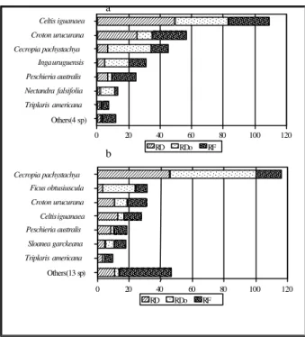
With regard to species IV, the two areas have important differences in their structures (Fig. 4).
In the margin dyke only two species, Celtis
iguanaea and Croton urucurana contributed more than half the total IV, with predominance of the
former. In the low area, Cecropia pachystachya
was predominant, with Celtis iguanaea occupying
4th place in IV. Ficus obtusiuscula, placed second
in IV in the low area, was not sampled in the
margin dyke. Out of 131 individuals of Cecropia
pachystachya sampled in the total area, 116
(88.5%) were registered in the low area. Seventy
eight individuals (70.3%) of Celtis iguanaea were
in the margin dyke (Table 5 and 6 - Annex).
Higher density of individuals of Cecropia
pachystachya was registered in the strip
Figure 4 - IV with values of relative Density (RD), relative Dominance (RDo) and Relative Frequency (RF) for the principal species in the margin dyke (a) and in the low area (b).
Clayey and hydromorphic soil is the principal characteristic of the communicating channel. The same applies to the lowest area of the frequently flooded terrain. High concentration of this species in area with such characteristics was also registered by Campos et al. (2000). Since the area was frequently flooded, the authors stated that occupation niche was restricted to few species adapted to such conditions. Species was a case in question. According to these findings and taking into account that it was a general species within the region, its high density in the area close to the channel seems to be related to tolerance and resistance of the species to environments
frequently subjected to flooding (Fig. 5). Croton
urucurana had a more equitable distribution than
Cecropia pachystachya in the area under analysis. Out of the 69 individuals sampled in the total area, 40 (58.00%) were in the dyke and the rest in the low area (42.00%). Besides the dead category, nine more species are exclusive of the low area
and only one species (Rapanea sp) was sampled as
exclusive of the margin dyke.
10 20 30 40 50 60 70 80 90 1 0 0 m e t e r s
0 5 10 15
20 I n d i v i d u a l s n u m b e r
C . u r u c u r a n a I . u r u g u e n s i s F . o b t o s i u s c u l a
10 20 30 40 50 60 70 80 90 1 0 0 m e t e r s
0 10 20 30 40 50 60
70 I n d i v i d u a l s n u m b e r
C . p a c h y s t a c h y a C . i g u a n a e a
0 2 1 0 2 0 3 0 4 0 5 0 6 0 7 0 8 0 9 0 1 0 0 1 1 0 1 2 0 m
0 0 , 5 1 1 , 5 2 2 , 5 3
m
P r o f i l e t e r r a i n
Figure 5 - Distribution of species (a and b) and cross section of terrain of area under analysis (c).
Alluvial soil Hydromorphic soil
Lake Paraná river
a)
b)
c)
Celtis iguanaea
Croton urucurana
Cecropia pachystachya
Inga uruguensis
Peschieria australis
Nectandra falsifolia
Triplaris americana
Others(4 sp)
0 20 40 60 80 100 120
RD RDo RF
Cecropia pachystachya
Ficus obtusiuscula
Croton urucurana
Celtis iguanaea
Peschieria australis
Sloanea garckeana
Triplaris americana
Others(13 sp)
0 20 40 60 80 100 120
RD RDo RF
a
The highest concentration of individuals of Inga uruguensis was found in the margin dyke. Out of sixteen individuals, eight were in the dyke; out of these, five were in the sampling on the river margin. In the low area four individuals were sampled. The other four were in the sampling near
the transition zone between the dyke and the low area. Campos et al. (2000) detected in a transect on the right margin of the Paraná river (in an area close to that analyzed in this study) that the species didn’t follow a clearly defined distribution pattern.
a)
b)
c)
Figure 6 - DCA showing grouping of analysed strips (a), soil cross section and physical
distribution of strips (b) and distribution of species corresponding to strips analysed by DCA (c).
Concerning successional categories, margin dyke had a higher value in IV totality of pioneer
species. Celtis iguanaea occupied more than a
third of recorded value (108.91). Distribution of these values for successional categories in the low area were more equitable, with predominance of Alluvial soil
AXIS 1 A
X I S 2
Strip 1
Strip 2 Strip 3
Strip 4
Strip 5
Strip 6
Strip 7
Strip 8
Strip 9
Strip 10
- 20 0 20 40 60 80 100 120
- 20 20 60 100 140 180 220
1 2 3 4 5 6 7 8 9 10
STRIPS 0
0,5 1 1,5 2 2,5
3 m
PROFILE TERRAIN
AXIS 1 A
X I S 2
P. sellowii Rapanea sp
P. tuberculatum
C. lasyophylla
F. obtusiuscula
Morta
-500 -300 -100 100 300 500 700
-500 -400 -300 -200 -100 0 100 200 300 400
R. emarginata
X. glaberrimum
C. pachystachya
Flacourtiaceae
S. garckeana C. urucurana
I.uruguensis
N. falsifolia T.americana P. australis
V.montevidensis O. diospyrifolia A. hasslerii
P.carthagenensis
C. iguanaea
Hydromorphic soil Alluvial soil
pioneer species. In spite of dominance of Celtis
iguanaea in the margin dyke, Cecropia
pachystachya registered the greatest contribution in absolute and relative terms in the composition of value for pioneer species in total area (42% of IV).
Concerning the secondary category, the highest value in the low area (compared to that in the margin dyke) showed that successional process was more dynamic in the low area. It was probably due to higher diversity of environments and to dominance of species with open tops, which favor the development of more species.
DCA of IV of all species in sampled area clearly separated the sampled strips and the species characteristic of the distinct environments (Fig. 6). Strips of sampled area were separated into three
distinct groups (ë1 = autovalues for axis 1 = 0.41):
strips 1, 3, 4 and 5 for the margin dyke environment; strips 2, 6 and 7 for the intermediate region; strips 8, 9 and 10 for the low area. Axes 1
and 2 (ë2 = 0.1) in Fig. 6c separate the most
characteristic species of certain strips, such as
Rapanea sp, sampled only in strip 1 and
Picramnia sellowii, sampled in strip 10. With the exception of strip 2, groupings by DCA was the real disposition of strips in the sampled area, where strips 1 to 5 lie in the dyke, strips 6 and 7 lied in the ecotone between the two environments and strips 8, 9 and 10 lied in the low area. This fact suggested the relationship between vegetation and the physical characteristics of the environments.
CONCLUSION
The dynamics of alluvial deposits in the high Paraná river favours the formation and the development of new areas (sandbanks) and gives rise to the colonization and the development of vegetation of great importance to ecological studies of primary and secondary succession. The river’s hydrodynamic and hydrosedimentological regimes influenced the physical and chemical composition of soil and determined distinct categories of morphology, texture and fertility. The structure, dynamics and distribution of species were related to the environment’s characteristics which determined the success in the establishment and exclusion of certain species.
In the alluvial forest studied in this research, the spatial heterogeneity of the substratum caused
floristic differentiation and diversification, only detected through detailed investigation. Vegetation of the studied area started with a process of primary succession when the sandbank was colonized in 1952; it developed towards a forest formation and was limited at present in its natural process of succession by cattle disturbance. Cattle removal and the protection of areas with similar characteristics could lead to a better interpretation of factors caused by the development and limitation of the successional process in areas of primary succession.
ACKNOWLEDGEMENTS
Acknowledgements are due to Course of Post-graduation in “Ecologia de Ambientes Aquáticos Continentais - Universidade Estadual de Maringá” and CNPq.
RESUMO
A dinâmica de deposições aluviais em planícies de inundação proporciona a formação de ilhas e barras (bancos de areia), que muitas vezes agregam-se às margens dos rios ou ilhas propiciando o seu crescimento lateral. Uma dessas barras, com início de formação a partir de 1952,
agregou a ilha Porto Rico (53o15’W e 22o45’S)
Table 4 - List of sampled species and dead in a remaining Alluvial Semideciduous Forest (4,500 m2) in the Porto Rico island, Brazil, with their respective phytosociological parameters: n = number of individuals; ns = number of samplings in which species occurred; RD = relative density; RDo = relative dominance; RF = relative frequency; IV = importance value and classification of ecological groups (EG): pioneer (P), secondary (S) and climax (C).
Specie EG n ns RD RDo RF IV
Cecropia pachystachya Trec. P 131 19 30,90 41,42 14,29 86,60
Celtis iguanaea (Jacq.) Sargent. P 111 21 26,18 13,18 15,79 55,14
Croton urucurana Baill. P 69 21 16,27 8,22 15,79 40,28
Inga uruguensis Hook & Arn. S 16 9 3,77 14,54 6,77 25,08
Peschiera australis (Müll. Arg.) Miers. S 33 15 7,78 2,01 11,28 21,07
Ficus obtusiuscula (Miq.) Miq. S 8 6 1,89 11,41 4,51 17,81
Sloanea garckeana K.Schum. S 14 7 3,30 3,22 5,26 11,79
Nectandra falcifolia (Nees.) Cast. ex Mez. S 8 6 1,89 3,43 4,51 9,83
Triplaris americana L. S 11 6 2,59 1,39 4,51 8,50
Dead - 4 4 0,94 0,26 3,01 4,21
Casearia lasyophylla Eichler S 4 4 0,94 0,20 3,01 4,15
Flacourtiaceae S 3 3 0,71 0,18 2,26 3,14
Piper tuberculatum Jacq. C 2 2 0,47 0,08 1,50 2,05
Xylosma glaberrimum Sleumer S 2 2 0,47 0,07 1,50 2,05
Picramnia sellowii Planch. S 2 2 0,47 0,06 1,50 2,04
Vitex montevidensis Cham. S 1 1 0,24 0,15 0,75 1,14
Rollinia emarginata Schlent. S 1 1 0,24 0,06 0,75 1,05
Psychotria carthagenensis Jacq. C 1 1 0,24 0,03 0,75 1,02
Rapanea sp. S 1 1 0,24 0,03 0,75 1,02
Ocotea diospyrifolia (Meissn.) Mez. S 1 1 0,24 0,03 0,75 1,02
Albizzia hasslerii (Chodat) Burr. S 1 1 0,24 0,02 0,75 1,01
Table 5 - List of sampled species and dead in phytosociological subanalysis of low area in the remaining Alluvial Semideciduous Forest (2,100m2) in the Porto Rico island, Brazil, with their respective phytosociological parameters: n = number of individuals; ns = number of samplings in which species occurred; RD = relative density; RDo = relative dominance; RF = relative frequency; IV = importance value.
Specie n ns RD RDo RF IV
Cecropia pachystachya Trec. 116 13 45,67 54,65 15,85 116,18
Ficus obtusiuscula (Miq.) Miq. 8 6 3,15 20,85 7,32 31,32
Croton urucurana Baill. 27 10 10,63 8,34 12,20 31,17
Celtis iguanaea (Jacq.) Sargent. 33 9 12,99 3,98 10,98 27,95
Peschiera australis (Müll. Arg.) Miers. 21 7 8,27 2,10 8,54 18,90
Sloanea garckeana K.Schum. 13 6 5,12 5,46 7,32 17,89
Triplaris americana L. 8 4 3,15 1,72 4,88 9,75
Nectandra falcifolia (Nees.) Cast. ex Mez. 5 5 1,97 0,71 6,10 8,78
Dead 4 4 1,57 0,48 4,88 6,93
Inga uruguensis Hook & Arn. 4 3 1,57 0,50 3,66 5,74
Flacourtiaceae 3 3 1,18 0,32 3,66 5,16
Casearia lasyophylla Eichler 3 3 1,18 0,13 3,66 4,97
Picramnia sellowii Planch. 2 2 0,79 0,12 2,44 3,34
Vitex montevidensis Cham. 1 1 0,39 0,28 1,22 1,89
Rollinia emarginata Schlent. 1 1 0,39 0,12 1,22 1,73
Psychotria carthagenensis Jacq. 1 1 0,39 0,06 1,22 1,67
Ocotea diospyrifolia (Meissn.) Mez. 1 1 0,39 0,05 1,22 1,67
Piper tuberculatum Jacq. 1 1 0,39 0,05 1,22 1,67
Albizzia hasslerii (Chodat) Burr. 1 1 0,39 0,04 1,22 1,65
Table 6 - List of sampled species in phytosociological subanalysis of margin dyke in the remaining Alluvial Semideciduous Forest (2,250m2) in the Porto Rico island, Brazil, with their respective phytosociological parameters: n = number of individuals; ns = number of samplings in which species occurred; RD = relative density; RDo = relative dominance; RF = relative frequency; IV = importance value.
Specie n ns RD RDo RF IV
Celtis iguanaea (Jacq.) Sargent. 78 12 49,37 33,78 26,09 108,91
Croton urucurana Baill. 40 10 25,32 9,78 21,74 56,84
Cecropia pachystachya Trec. 11 5 6,96 27,46 10,87 45,19
Inga uruguensis Hook & Arn. 8 5 5,06 15,63 10,87 31,56
Peschiera australis (Müll. Arg.) Miers. 11 7 6,96 2,33 15,22 24,51
Nectandra falcifolia (Nees.) Cast. ex Mez. 3 1 1,90 9,25 2,17 13,32
Triplaris americana L. 3 2 1,90 1,37 4,35 7,62
Casearia lasyophylla Eichler 1 1 0,63 0,38 2,17 3,19
Xylosma glaberrimum Sleumer 1 1 0,63 0,18 2,17 2,98
Piper tuberculatum Jacq. 1 1 0,63 0,15 2,17 2,96
Rapanea sp 1 1 0,63 0,10 2,17 2,91
REFERENCES
Agostinho, A. A. and Zalewski, M. (1996),A planície alagável do alto rio Paraná: importância e preservação. Maringá - PR : EDUEM. 100 pp.
Assis, M. A. (1991), Fitossociologia de um remanescente de mata ciliar do rio Ivinheima (MS), Dissertação de Mestrado em Biologia Vegetal. Campinas-SP, Brasil : Instituto de Botânica. Universidade Estadual de Campinas. 163 pp.
Budowski, G. (1963), Forest succession in tropical lowlands. Turrialba,13 :(1), 42-44.
Budowski, G. (1965), Distribution of tropical american rain forest species in the light of sucessional processes. Turrialba, 15, 40-42.
Budowski, G. (1966), Los bosques de los trópicos húmedos de América. Turrialba, 16 : (3), 278-285. Campos, J. B. and Souza, M. C. (1997), Vegetação. In:
Vazzoler, A. E. A. M., Agostinho, A. A. and Hahn, N. S. (eds). A planície de inundação do alto rio Paraná: aspectos físicos, biológicos e socioeconômicos. Maringá : EDUEM : Nupélia. pp. 331-342.
Campos, J. B. (1999), Spatial and multi-temporal analysis of deforestation and quantification of the remnant forests on Porto Rico island, Paraná, Brazil. Brazilian Archives of Biology and Technology, 42 : (1), 91-100.
Campos, J. B., Romagnolo, M. B. and Souza, M. C. (2000), Structure, composition and spatial distribution of tree species in a remnant of the semideciduous seasonal alluvial forest of the Upper Paraná River Floodplain. Brazilian Archives of Biology and Technology, 43 : (2), 185-194.
Denslow, J. S. (1980), Gap partitioning among tropical rainforest tree. Tropical Succession, 47, 47-55.
EMBRAPA/IAPAR (1984), Serviço Nacional de Levantamento e Conservação de Solos, Rio de Janeiro, RJ. Levantamento e reconhecimento dos solos do Estado do Paraná. Curitiba, 1984. 2 v. : il. (Embrapa - SNLCS. Boletim técnico; 27).
Gómez-Pompa, A. and Wiechers, B. L. (1976), Regeneración de los ecosistemas tropicales y subtropicales. In: Gomez-Pompa, A.; Vasquez-Yanes, C.; Rodriguez, S. A. and Butanda Cervera, A. (eds). Regeneracion de selvas. Mexico : Continental. pp. 11-30. Hill, M. O. and Gauch, H. G. T. (1980), Detrended Correspondence Analysis: an improved ordenation technique. Vegetatio,42, 47-58.
IBGE - Fundação Instituto Brasileiro de Geografia e Estatística. (1992), Manual técnico da vegetação brasileira. Rio de Janeiro : IBGE. 92 pp. (Série Manuais Técnicos em Geociências; 1).
Kageyama, P. Y. and Equipe técnica da CESP. (1992), Recomposição da vegetação com espécies arbóreas nativas em reservatórios de usinas hidrelétricas da CESP. Série técnica IPEF, Piracicaba (BRA), 8 : (25), 1-43.
Mantovani, V. (1989), Dinâmica de populações. In- Barbosa, L. M. (Coord.). Anais do Simpósio sobre Mata Ciliar, 1, Campinas, SP : Fund. Cargill. pp. 120-129.
Mateucci, S. and Colma, A. (1982), Metodologia para el estudio de la vegetación. Washington D.C., Secretaria general de la Organización de los Estados Americanos. OEA. 168 pp.
Müeller-Dombois, D. and Ellenberg, H. (1974), Aims and methods of vegetation ecology. New York : John Wiley & Sons. 547 pp.
Neiff, J. J. (1986), Las grandes unidades de vegetacion y ambiente insular del rio Paraná en el tramo Candelaria - Ita Itabe. Revista de la Associacion de Ciencias Naturales del Litoral, 17 : (11), 7-13. Odum, E. P. (1986), Ecologia. Rio de Janeiro :
Romagnolo, M. B. (1997), Análise da mata ciliar do alto rio Paraná, município de Taquaruçu, MS. UEM. Dissertação (Mestrado). Curso de Pós-Graduação em Ecologia de Ambientes Aquáticos Continentais. Depto. de Biologia - Universidade Estadual de Maringá. 25 pp.
Santos, M. L.; Fenandez, O. V. Q. and Stevaux, J. C. (1992), Aspectos morfométricos das barras de canal do rio Paraná.Boletim de geografia,10 : (1), 11-24. Sharif, A. H. M.; Miller, H. G. and Appanah, S. (1990),
Soil fertility and tree species diversity in two Malasyan forest. Journal of Tropical Forest Science,
3 : (4), 318-331.
Soares, P. R. B. and Perez Filho, A. (1997), Recomposição de mata ciliar em planície de inundação - Proposta metodológica. In: Simpósio nacional de recuperação de áreas degradadas,(3). Anais... Ouro Preto : SOBRADE/UFV. pp. 14-26.
Souza, M. C., Cislinski, J. and Romagnolo, M. B. (1997), Levantamento florístico. In: Vazzoler, A. E. A. M.; Agostinho, A. A. and Hahn, N. S. (eds). A planície de inundação do alto rio Paraná:aspectos físicos, biológicos e socioeconômicos. Maringá : EDUEM : Nupélia. pp. 344-368.
Stevaux, J. C. (1994), Geomorfologia, sedimentologia e paleoclimatologia do alto curso do rio Paraná (Porto Rico, Pr.). Boletim Paranaense de Geociências, 42, 97-112.
Stutz de Ortega, L. C. (1987), Etutes floristiques de divers stades secondaires des formations forestières du Haut Parana (Paraguay oriental) - Structure, composition floristique et régénération naturelle: comparaison entre forêt primaire et la forêt sélectivement exploitée. Condollea (Genève), 42, 205-262.
Welcomme, R. L. (1979), Fisheries ecology of floodplain rivers. London : Logman. 317 pp.