Spatial and Multi-temporal Analysis of Deforestation and
Quantification of the Remnant Forests on Porto Rico Island,
Paraná, Brazil
João Batista Campos
Instituto Ambiental do Paraná IAP. Av. Bento Munhoz da Rocha Neto, 16. CEP 87.030010 Maringá Paraná -Brazil
ABSTRACT
The process of land occupation by the state of Paraná practically decimated its forests. Presently, only 7% from a total area of 83.41% is covered by forests. Most of them are now concentrated in the "Serra do Mar" and in the Iguaçu National Park. With regard to forest cover the most critical region is situated in the northwestern of the state with less than 1% of its area covered by forest. This restricted area mainly consists of conservation units and the islands of the high Paraná River floodplain. The present study consists of a spatial and multi-temporal analysis of deforestation and the quantification of the remnant forests on Porto Rico island (22o45’S; 53o15’W), which have their occupation history linked to the colonization process of the region. Historical aerial photographs of this region were used and the relationship of deforestation with the process of colonization and social transformation of the region is discussed.
Key words: photogrammetry, alluvial forest, floodplain, forest.
INTRODUCTION
Originally, the state of Paraná had 83.41% of its area covered with forests (Maack, 1968). The process of territorial occupation of the state began from the Atlantic coast, reached the first plateau of Curitiba and rapidly developed on the second and third plateaux towards the Paraná river. The process practically decimated whole forests; currentlly only about 7% of the original forest cover remains (Fundação SOS Mata Atlântica 1992/93).
In the area of convergence of the high Paraná river floodplain, between the states of Paraná and Mato Grosso do Sul, the situation is more critical. Forests have been almost totally destroyed. The original forest covering the northwestern area of the state of Paraná doesn't surpass 1%; in Mato Grosso do Sul deforestation already reached critical levels with only 42.2% of native vegetation in the whole state and 0.83% in the southern area (Fundação
SOS Mata Atlântica 1992/93; Fundação Ipardes, 1992).
The fluvial archipelago of the Paraná river between the states of Paraná and Mato Grosso do Sul is formed by a wide alluvial channel with low declivity (7cm/km) (Souza-Filho & Stevaux, 1997), braided channels, hundreds of small lakes and more than 300 islands (Agostinho & Zalewski, 1996) whose history is tied up with the territorial occupation of the state of Paraná .
MATERIALS AND METHODS
Study area
The area under analysis is one of the several islands that compose the fluvial archipelago of the High Paraná river. According to the most recent official map of the area (1980), the island hadan area of 107.55 ha, lying approximately at
22o45'S and 53o15'W. The climate of the area according to the Köeppen system is Cfa -tropical-subtropical climate with hot summer (annual average of 22oC) and annual medium precipitation of 1.500 mm (Campos & Costa-Filho, 1994). Altitude of the area is close to 230 m above sea level (Fig. 1).
53 30’o
53 15’o
CITY CITY
PARANÁ
MATO GROSSO DO SUL
23 00’o
22 45’o 22 45’o
PARANÁ STATE
STATE
STATE
DIRECTION OF FLUX
ADVANCED LAB OF NUPELIA
Region of study BRAZIL
PORTO RICO PORTO RICO
Baia Riv
er
Para ná R
iver
Paran á Rive
r
Para ná R
iver
Iv
in
h
em
a
Riv er
Iv
in
h
em
a
R iver
Mutum Island
Mut um I
slan d
Porto Rico
Islan d
N
1 km
Fig. 1. Site of the area under analysis
The area is situated in the Semideciduous Seasonal Forest phytoecological region and the local vegetation is classified as Semideciduous Seasonal Alluvial Forest (IBGE, 1992; Campos & Souza, 1997).
Methodology
Vertical metric aerial photographs obtained in the years 1952 (scale 1:25.000), 1965 (1:40.000), 1970 (1:50.000), 1980 (1:25.000) and 1996 (1:50.000) were used for multi-temporal evaluation of deforestation and for the spatial quantification of the vegetation. Aerial photographs were analyzed and interpreted visually, with the aid of a stereoscope, and geo-referenced to a cartographic basis (Loanda
sheet, SF.22-Y-A-V DSG/IBGE, scale 1:100.000).
The mapping of the identified vegetation types was elaborated by means of overlays of transparent sheets, fed into the SGI/INPE® program, with calculations of areas and perimeter limitations on the photos already digitally formated. The COREL-DRAW version 7.0 was used for final edition of the photo-maps and legends were placed according to the patterns related to the vegetation types identified in the aerial photographs.
research projects reports and interviews with technicians responsible for the area’s surveys were consulted.
RESULTS AND DISCUSSION
History of occupation
The occupation process of the territory of Paraná is a relatively recent occurrence. Until the beginning of this century, economic activity
occurred in less than a third of the area of the state and was restricted and concentrated on the coast and in the south. Products that formed the basis of the state’s economy, such as gold in the 17th century and the extraction, industrialization and export of the maté tea and wood in the 19th and early 20th centuries, were exploited. As from 1930, an accelerated phase of the destruction of Paraná forests took place
(Codesul, 1989) (Table 1).
Table 1. Historical process of deforestation and percentages of forest covering the state of Paraná (1890 - 1990).
Year Original forest (km2)
Deforested area (km2) Annual index of deforestation (km2)
Covering Forest (%)
1890 167,824 - - 83.411
1930 129,024 38,800 970 64.121
1937 118,022 49,801 1,571 58.651
1950 79,834 87,990 2,938 39.671
1965 48,136 119,688 2,113 23.921 1980 23,943 143,881 1,613 11.902
1985 16,468 151,356 1,495 8.393
1990 15,030 152,794 287 7.593
1
Maack (1968) 2
Inventário de Florestas Nativas (IBDF) (Gubert-Filho, 1993) 3Fundação SOS Mata Atlântica
(1992/93)
The original forests formerly covering 83.41% of the 201,203 km2 of the total area of Paraná (Maack, 1968) suffered a fast degradation. Since deforestation rhythm is linked to the colonization process and the expansion of the agricultural area, the highest peak observed in the annual index of deforestation occurred between 1937 and 1950 (2,938km2). This fact coincided with the beginning of colonization of the northern part of Paraná, specifically in the area around the city of Londrina, founded in 1937, from which several districts and towns were dismembered, such as Apucarana (1943), Rolândia (1943), Arapongas (1947) and Mandaguari (1947).
The second largest annual index of deforestation (2,113 km2) occurred between 1950 and 1965, and it was related to the process of colonization of the northwestern areas, or rather, with the foundation of the cities of Maringá (it became a district in 1951), Paranavaí (1951), Umuarama (1960); also in the southwestern region of
Paraná, where the cities of Cascavel (1951), Francisco Beltrão (1951), Pato Branco (1951) and Toledo (1951) were founded.
Between 1965 and 1985, deforestation indexes decreased from 1,613 km2/year-1 to 1,495 km2/year-1, although indexes remained relatively high. This was the era of the expansion of the agricultural frontier in the southwestern and northwestern regions of the state towards the Paraná river.
Initially, the colonization of the northwestern area was the initiative of the state’s government when it founded the colony of Paranavaí in 1939. The town was elevated to district category
in 1951; several districts were later on dismembered from the original town (Outline 1).
Outline 1. Origin of the district of Porto Rico, Paraná, Brazil, and year of foundation of the original districts (Source: SEMA 1997)
Paranaguá (1648)_____________________________________________________________________ Coast
L Curitiba (1693)
L Castro (1789) _______________________________________________________________ 1o
Plateau L Tibagi (1872)
L S. Jerônimo da Serra (1920)__________________________________________ 2 o
Plateau L Jataí (1932)
L Londrina (1934) L Apucarana (1943)
L Mandaguari (1947) L Paranavaí (1951)
L Porto Rico (1963)_____________ 3 o Plateau
Regional context of Porto Rico island
The district of Porto Rico is situated on the bank of the Paraná river and has several islands whose occupation history is linked to that of the town of the same name.
The island under analysis is called Porto Rico island and is situated in front of the town of Porto Rico. By the 1983 agreement, INCRA (National Institute for Colonization and Agrarian Reform), the organization responsible for land regulatation in Brazil, transferred authority for the survey of land regulation on the islands of the Paraná river to the Institute of Land, Cartography and Forest (ITCF, currently Environmental Institute of Paraná, IAP). Because of boundary indefinition between the states of Paraná and Mato Grosso do Sul, technicians of ITCF established the deepest sounding of the river bed and thus, a criterion for the boundary between the two states.
According to Feuerschuette (1985), there was a juridical controversy regarding the islands of the Paraná river, or rather, the jurisdiction of limiting states over the islands. The author emphasized that the political and administrative jurisdiction exercised by the state of Paraná or by the frontier districts has been defined and consolidated throughout the years. Moreover, with regard to interstate boundaries, it was emphasized that river soundings criteria,
establishing the bordering line of the state territories, would with great difficulty prevail on that of the political and administrative jurisdiction exercised by the Paraná state. This was especially true because of the great mobility of the channel as a result of the flood cycle and sand accumulation, both factors favouring constant changes. In a study on sedimentology in the high Paraná river floodplain, Stevaux (1994), contemplating a specific section in the area of Porto Rico, confirmed intense migration and changes in the soundings of the Paraná river.
Taking into consideration the fact that the history of occupation of the islands of the Paraná river, especially of the island under analysis, is linked to the state of Paraná, the discussion on the deforestation process and its connection to the Paraná State are rightly justified.
Land occupation on Porto Rico island
3 residents existed on the island. Same numbers were registered for 1993 (FUEM/CIAMB-PADCT, 1993). Now, the island is occupied by two “presumed owners”, extensive cattle raising, a single house occupied eventually by one of the proprietors who actually lives in the town of Porto Rico.
According to FUEM/CIAMB-PADCT (1993), the islands of the Paraná river became heavily occupied in the 70s when transformations in agriculture and cattle raising expansion expelled the small proprietors, partners, lessees and leaseholders of the rural areas of the districts in the neighbourhood of the Paraná river. On the other hand, changes in agricultural production, the "modernization" of agriculture, the substitution of the coffee plantations by cattle raising(the latter demanding heavy expansion of area) and the flood of 1982/83 provoked the expulsion and displacement of the population living on the islands of the Paraná river during the 80s and, probably, land concentration.
In spite of the occupant decrease between 1987 and 1997, the degradation process and deforestation of the island didn't diminish, as may be seen below.
Total area of Porto Rico island – Silt
deposition and erosion
The total area of the island related to dynamics of silt deposition and erosion by the Paraná river underwent several dimensional variations. In 1952, the reference year for the original forest covering in this study, the island had 101.31 ha. A coalescent sandbank in formation and the initial stage of colonization may be identified from the aerial photographs. The sandbank developed and fused itself to the island. In the 1965 aerial photograph, an increase of 12.4 ha to the total area might be noted, establishing the island’s area at 113.71 ha.
The coalescent or fusing sandbank had already been identified by Santos et al. (1992). According to these authors, these sandbanks are diagonal appendixes to the islands and fused to the latter upstream. Such a fusion and the formation of a channel between the fused sandbank and the original bank of the island may be observed in the aerial photography of 1965.
From 1965, an erosion process began on the island with loss of area, reaching to the current level of 103.12 ha (Table 2).
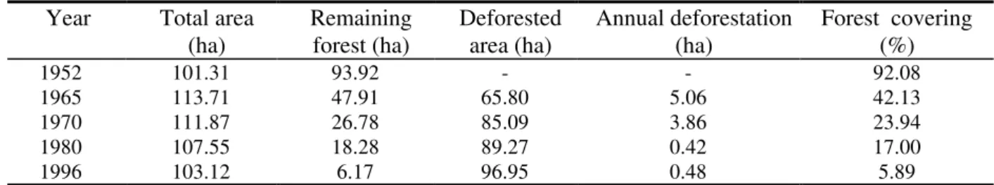
Table 2. Total area, historical process of deforestation and percentage of forest covering for Porto Rico island (1952 - 1996).
Year Total area (ha)
Remaining forest (ha)
Deforested area (ha)
Annual deforestation (ha)
Forest covering (%)
1952 101.31 93.92 - - 92.08
1965 113.71 47.91 65.80 5.06 42.13
1970 111.87 26.78 85.09 3.86 23.94
1980 107.55 18.28 89.27 0.42 17.00
1996 103.12 6.17 96.95 0.48 5.89
The speed of area loss may be associated with the occupation and deforestation process of the island. The interlacement of roots at several depths by forest vegetation in its several strata (arboreous, shrub and herbaceous) favoured the agglutination and cohesion of soil particles, increasing resistance to disaggregation with a consequent decrease of the erosive process. On the other hand, extensive cattle raising on the island caused the disembankment of the margins (when cattle went to the river to drink the water) and contributed to the erosion process. Perhaps popular culture picked up in one of the many meetings with the local population fits in very
well: “Elsewhere, the riparian vegetation protects the water of the river from the soil that erosion carries away. It is different in the Paraná river. Riparian vegetation protects the soil of the islands from the waters of the river”. This is a clear allusion to the protection that the riparian forest gives to the islands against the erosive effect of the river.
Deforestation in Porto Rico island
Fig. 2. Evolution of deforestation in the Porto Rico island for the years 1952, 1965, 1970, 1980 and 1996.
1980
22º 45’ S
53º 15’ W
Legend 1980 ha
Forest
% 18,28 17,00 Deforested area 89,27 83,00
Total 107,55 100,00
22º 45’ S
1965
53º 15’ W
Legend 1965 ha
Forest
% 47,91 42,13
Deforested area 65,80 57,87
Total 113,71 100,00
1970
22º 45’ S
53º 15’ W
Legend 1970 ha
26,78 %
23,94
Deforested area 85,09 76,06
Total 111,87 100,00
53º 15’ W 1952
Legend 1952 ha
Forest
% 93,29 92,08 Sanbank in colonization 2,21 2,18 Area in colonization 5,81 5,74
Total 101,31 100,00
Para náRiv
er
150 150 300 450 600 m Scale
0
1996
22º 45’ S
From the photo-maps, it could be observed that Porto Rico island had all its original vegetation seemingly intact in 1952 when 92.08% of its total area was covered by forest and the remaining percentage was distributed between vegetation areas (5.74%) and in sandbanks with incipient colonization (2.18%).
Between 1952 and 1965, more than half of the island was already deforested (57.87%). Between 1965 and 1970, deforestation process practically maintained the same rhythm (Fig. 3).
a) b)
1952 1965 1970 1980 1996
Anos 0
20 40 60 80 100 120
Area (ha)
Total area Remaining forest Deforested area desflorestada
1952 1965 1970 1980 1990 1996
Anos 0
20 40 60 80 100
%
Porto Rico island Paraná State
Fig. 3. a) Total area, deforested area and remaining forests in the Porto Rico island between 1952 and 1996 and b) percentage of remaining forests of the Porto Rico island and Paraná State (1952 - 1996).
Deforestation rhythm coincided with the colonization process and social transformations in the area. Rosa (1997) stated that between 1962 and 1967, due to the overproduction of coffee in Brazil and in order to maintain the product’s international prices, the coffee shrub eradication policy was employed. Two hundred and five million coffee shrubs were uprooted. In the northwestern area of Paraná, sixty two million coffee shrubs were eliminated and pasture was introduced in the area. Since coffee plantation undoubtedly absorbed a great deal of labour, the eradication of the coffee shrubs expelled part of the population in the area as a consequence (Rosa, 1997 p.381). The islands of the Paraná river, considered as peripherical areas to agricultural exploration, served at that time as absorption areas for the population expelled from the rural production environment (FUEM/CIAMB-PADCT, 1993). This fact may explains the deforestation speed until 1970.
Between 1970 and 1996, the deforestation rhythm greatly decreased. This fact should be attributed to the exhaustion process of the remaining forest, which only occupied 25% of
the area of the island in 1970. Between 1970 and 1996, 18.1 ha were deforested and at present only 3 florest fragments remain on the island, totalling 6.17 ha, which represented 5.98% of its area.
In terms of annual rhythm of deforestation, high values have been observed in the beginning of the occupation (up to 1970), with a decrease in subsequent years (Table 2 and Fig. 3a). In spite of a decrease in the number of occupants of the island between 1980 and 1996, deforestation maintained the same rhythm as that of the period comprising 1970 to 1980. This was probably due to the expansion of deforested areas used for cattle raising.
CONCLUSIONS
Due to the physical smallness of the area, necessarily needing cartographic bases at large scales, aerial photographs have been a valuable instrument in the reconstruction of the history and true situation of the area’s deforestation. Due to the available multi-temporal series and their high resolution level, aerial photographs are especially indicated for identification, quantification, spatial location and establishment of plans and directives for area reforestion and forest recovery in small and large enterprises. This study has been useful in analysing the historical evolution of the island’s ocuppation: although it really began in 1952, deforestation on Porto Rico island quickly reached the levels of the state and followed closely the Paraná level of forest destruction.
The occupation process and deforestation of Porto Rico island seem to be related not only to the colonization process but also to the social changes occurring in the area, mainly the substitution of cultures that use a great amount of labour (for instance, coffee plantations) by activities that need area expansion for production with few employees (for instance, cattle raising). Consequently, land concentration and utilization excesses in the occupation of the agricultral frontier are brought about.
Considering that, according to the law, all properties should have at least 20% of their total area as forest reserve, besides those constituting permanent preservation, and since on Porto Rico island only 5.89% of its area is covered with forests, it could be concluded that Porto Rico island is being used illegally. Consequently, urgent action is needed towards the recovery of its destroyed forests.
ACKNOWLEDGEMENTS
Achnowledgements are due to SENAGRO -Sensoriamento Remoto S.A., especially to Francisco Lothar Paulo Lange Jr. and Carmen Truite, for the collaboration in the making of the photo-maps and to Prof. Maria Cristina Rosa for the suggestions presented in the discussion of
the paper. To Curse of Post-graduation in “Ecologia de Ambientes Aquáticos Continentais - Universidade Estadual de Maringá” and CNPq.
RESUMO
O processo de ocupação das terras do Paraná praticamente dizimou as florestas do Estado, que originalmente possuía 83,41% de sua área total coberta com florestas. Atualmente remanescem aproximadamente 7% da área com florestas, concentradas na Serra do Mar e no Parque Nacional do Iguaçu. Na região noroeste, a situação é mais crítica, com menos de 1% de sua área coberta por florestas, concentradas, principalmente, em unidades de conservação e nas ilhas da planície de inundação do alto rio Paraná. Esta planície é formada por uma ampla calha aluvial, com inúmeros canais, lagoas e ilhas, que têm sua história de ocupação ligadas ao processo de colonização na região. Neste trabalho, é realizada uma análise espacial e multi-temporal dos desflorestamentos e uma quantificação das florestas remanescentes da ilha Porto Rico (22o45’S; 53o15’W), por meio de fotografias aéreas históricas da região e discutidas as relações destes desflorestamentos com os processo de colonização e transformações sociais ocorridas na região.
REFERENCES
Agostinho, A.A.; Zalewski, M. (1996), A planície alagável do alto rio Paraná:
importância e preservação, Maringá - PR :
EDUEM. 100p.
Campos, J.B. (in press), Unidades de Conservação no Estado do Paraná: ações e contradições. Revista do Instituto Florestal -Série Registros.
Campos, J.B.; Costa-Filho, L.V. (1994),
Proposta técnica de implantação da área de proteção ambiental do Arquipélago de ilha
Grande. Curitiba-PR : SEMA/IAP. 54p.
Campos, J.B.; Souza, M.C. (1997), Vegetação.
In: A Planície de Inundação do Alto Rio
Paraná: aspectos físicos, biológicos e
Agostinho, A.A.; Hahn, N.S. Maringá : EDUEM : Nupélia, 1997. pp. 331-342. Codesul - Conselho de Desenvolvimento do
Extremo Sul. (1989), Diretrizes para a preservação e conservação da natureza e para o desenvolvimento florestal na região
sul do Brasil. Curitiba - PR, 60p.
Feuerschuette, R.C. (1985), Parecer no. 146/84/PROJU - ITC. Revista de Direito
Agrário e Meio Ambiente, 1, 150-152.
FUEM/PADCT-CIAMB. (1993), Estudos ambientais da planície de inundação do rio Paraná, no trecho compreendido entre a foz do rio Paranapanema e o reservatório de
Itaipu. Maringá: Fundação Universidade
Estadual de Maringá. 3v. (Relatório de pesquisa - Apoio PADCT-CIAMB).
Fundação Ipardes. (1992), Diagnóstico para a implantação de políticas para o setor
florestal no Paraná. Curitiba - PR :
Fundação Ipardes. 48p.
Fundação SOS Mata Atlântica/INPE. (1992/93),
Atlas da evolução dos remanescentes florestais e ecossistemas associados do domínio da Mata Atlântica no período de
1985 - 1990. São Paulo : INPE. 20p.
Gubert-Filho, F.A. (1993), O desflorestamento do Estado do Paraná em um século. Paper presented at Conferência del Mercosur sobre Medio Ambiente e Aspectos Transfronteirizos, 61-69. Posadas, Argentina. IBGE - Fundação Instituto Brasileiro de Geografia e Estatística. (1992), Manual
técnico da vegetação brasileira. Rio de
Janeiro : IBGE. 92p. (Série Manuais Técnicos em Geociências; 1).
Maack, R. (1968), Geografia Física do Estado
do Paraná. Rio de Janeiro : J. Olympio.
442p.
Rosa, M.C. (1997), Processo de ocupação e situação atual. In: A Planície de Inundação do Alto Rio Paraná: aspectos físicos,
biológicos e socioeconômicos
, ed.
Vazzoler,A.E.A.M.; Agostinho, A.A.; Hahn, N.S. Maringá : EDUEM : Nupélia, 1997. pp. 371-394.
Santos, M.L.; Fenandez, O.V.Q.; Stevaux, J.C. (1992), Aspectos morfométricos das barras de canal do rio Paraná. Boletim de
Geografia, UEM-DGE, 10, 1, 11-24.
SEMA - Secretaria de Estado do Meio Ambiente e Recursos Hídricos do Paraná. (1997), Arquivo Gráfico Municipal do
Estado do Paraná. Curitiba. 53p.
Souza-Filho, E.E.; Stevaux, J.C. (1997), Geologia e geomorfologia do complexo rio Baía, Curutuba, Ivinheima. In: A Planície de Inundação do Alto Rio Paraná: aspectos
físicos, biológicos e socioeconômicos, ed.
Vazzoler, A.E.A.M.; Agostinho, A.A.; Hahn, N.S. Maringá : EDUEM : Nupélia, 1997.
pp. 3
-46.Stevaux, J.C. (1994). Geomorfologia, sedimentologia e paleoclimatologia do alto curso do rio Paraná (Porto Rico, Pr.). Boletim
Paranaense de Geociências, 42, 97-112.