Data Model for Geographic Ontologies
Generation
Marcirio Silveira Chaves, Catarina Rodrigues and M´ario J. Silva Department of Informatics
Faculty of Sciences - University of Lisbon 1749-016 Lisbon, Portugal
{mchaves,crodrigues,mjs}@xldb.fc.ul.pt
Abstract: Structured geographic information has an important role in many applications, such as geographically-aware search engines and named-entity (e.g., proper names) recognizers. This information is com-piled from resources like dictionaries, gazetteers and ontologies. The quality of the applications depends critically on the richness of these resources. This article describes a new version of the Geographic Knowl-edge Base (GKB), an environment for integrating geographic data and generating ontologies. We introduce the new metamodel of GKB and show how the information in its repository is transformed into OWL representations. We also present the data integration process of the ad-ministrative and physical domains, which deals with geographic relation-ships in both domains.
Keywords: modeling, geographic ontologies, ontology generation
1
Introduction
A well-defined model has an important role in any kind of system, facilitating its reuse and extension. The model-driven approach defines relationships among concepts in a domain and precisely specifies the key semantics and constraints associated with these domain concepts [1]. Considering that all information rep-resented in a system is constrained to the model, the modeling phase is crucial to determine what and how is possible to represent within an application.
The modeling becomes more complex when we try to bring together several views of different communities. The geographic knowledge domain is an example in which geographers, geographic engineers and computer scientists (when coping with geographic information) use different terminologies to represent the same information. These terminologies need to be integrated in a model, which must be able to consistently represent the geographic concepts. A consensual notion concerns the existence of two geographic domains: administrative and physical. Geographic Knowledge Base (GKB), an environment for integrating geo-graphic data and generating ontologies, is implemented based on a model able to support the storage of the information from administrative and physical domains [2,3]. The first version of GKB (GKB 1.0, henceforth) contains two instances: one
stores data about the geo-administrative and network (web) domains of Portugal and the other contains data from all over the world.
The information stored in GKB 1.0 is exported to ontologies in the OWL format. One of these ontologies (Geo-Net-PT01) contains the integrated ge-ographic administrative information of Portugal and is freely available from http://xldb.fc.ul.pt/geonetpt. Applications using Semantic Web technolo-gies can easily work with the ontolotechnolo-gies exported from GKB [4,5]. Other exam-ples of use of the ontologies generated by GKB 1.0 can be found in [6,7].
This article describes a new version of GKB (hereafter GKB 2.0), which supports a couple of new requirements. A more detailed representation of the geographic names and a better control of information sources among other im-provements should be provided by GKB 2.0. In addition, full support to the modeling of the physical domain and its integration with the administrative domain should also be present in the next version of GKB.
The main contribution of this article is a detailed description of the model for integrating geographic information from multiple domains and making this knowledge available as ontologies in a Semantic Web format. We are working on data about Portugal, but the model could be applied to represent geographic knowledge from any country or geographic region.
The structure of this article is as follows: Section 2 introduces the GKB re-quirements and Section 3 details the design of the new GKB model. Section 4 describes the geo-physical domain introducing new physical concepts and re-lationships. Section 5 shows the conversion of the GKB 2.0 model to OWL ontologies and Section 6 presents related work. Section 7 gives the final remarks.
2
GKB 2.0 Requirements
It is necessary to introduce the notion of the feature concept in this work, bor-rowed from the GIS (Geographic Information System) world, before we describe the requirements for GKB 2.0. A feature is “a meaningful object in the selected domain of discourse” as defined in ISO 19109 [8]. Examples of features in-clude the Douro river and the ´Alvares Cabral Avenue. Feature types, in the above examples are river and avenue, and their names are Douro and ´Alvares Cabral, respectively.
GKB 2.0 is centered on the notion of feature as in GKB 1.0, but includes a number of extensions:
Support for relationships between types: GKB 1.0 only supported rela-tionships between features, such as Lisbon is part-of Portugal. GKB 2.0 also supports relationships between feature types, such as rivers are part-of continents.
Support for generic property sets: All the major classes (feature, feature type and name) may now include arbitrary attributes, whose support is defined in the metamodel. For example, attributes to a river include source, outlet and length, while a soil has a PH level and a mountain has an
altitude. GKB 2.0 also provides a more detailed specification of feature names. Attributes of geographic names, like the language in which a name is given can be captured. In addition, it may store other attributes of the geographic names, such as time and demonyms. For example, Olissipo is an historic name of Lisbon and lisboeta one of the Portuguese demonyms of the inhabitants of Lisbon.
Better control of information sources: Data lineage was very simplistic and recorded only at the feature level in GKB 1.0. For example, all informa-tion related to the Municipality of Lisbon was associated to one informainforma-tion source. In GKB 2.0, each name, type and relationship can be independently associated to a distinct information source. This extension allows us to know, for example, that two types are provided by distinct information sources and the relationship between them is derived from a third information source.
3
GKB Metamodel
A model is an abstraction of phenomena in the real world, and a metamodel is yet another abstraction, highlighting properties of the model itself [9]. In GKB the metamodel describes the classes and relationships that are used to model geographic information. The GKB 2.0 metamodel supports representations of multiple information domains related to geography, such as the administrative and physical domains. In each of these domains, the information is organized using concepts from the metamodel (e.g. features, feature types and their rela-tionships).
3.1 Base Model
The core of the GKB 2.0 metamodel is represented in Figure 1. The class Feature is associated with the class Type, which stores the types (feature Douro is of type river). The class Type-Relationship captures the relationships between types (a Municipalityis part-of a Country).
The class Relationship-Type stores the supported relationships, such as part-ofand other relationships of geographic nature. Considering that a river is part-of a continent, the class Type-Relationship stores this relationship.
Features may be specialized by Feature-Footprints, which capture coordinate data. Coordinates represent centroids, bounding boxes and polygons. The feature Serra da Estrelahas a centroid at 40◦20N, 7◦38W.
3.2 Attributes and Names Representation
Figure 2 represents the base model of Figure 1 extended with the classes used for representing names and the attributes of types, features and names. Different geographic types have different attributes. A river has a length, a source and a mouth, while a mountain has an altitude and a municipality has population.
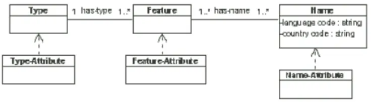
Figure 1.GKB 2.0 base class metamodel.
Figure 2.GKB 2.0 names and attributes model.
The classes Type-Attribute and Feature-Attribute add property sets to the base classes Type and Feature, respectively.
GKB 2.0 also provides better modeling of the geographic names. Each name is associated with a language and its country code (e.g., PT-BR), which are cap-tured in the class Name. The language coding adopted follows the language tag standard <language code“–”country code> defined by RFC 3066 of the IETF [10]. Names can also be extended with sets of attributes capturing preferences (e.g., a name is preferred or alternative), time (e.g., used in the nineteenth cen-tury), use (e.g., rare, colloquial) and demonyms. These are stored in the class Name-Attribute.
For example, the river Tajo has its equivalent in Portuguese Tejo and its historic name Tagus, from Latin. The attribute historic is captured in the class Name-Attribute, whereas the class Name stores the names (Tajo, Tejo and Tagus), its languages (ES, PT and LA) and its country codes (ES and PT), respectively.
3.3 Inter-domain Relationships
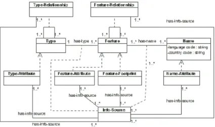
GKB 2.0 stores information on administrative and physical domains. In addition to modeling relationships between features in the same domain, it supports inter-domain relationships. Figure 3 shows the model representing the inter-inter-domain relationships.
Figure 3.Inter-domain relationships in GKB 2.0.
The class Adm-Feature contains information from the administrative do-main and the class Phy-Feature information from the physical dodo-main. The class ID-Type-Relationship (ID stands for inter-domain) stores relationships such as part-of and adjacency. For example, the municipalities of Lisboa and Set´ubal (administrative domain) are adjacent to the river Tejo (physical domain). This relationship is stored in the class ID-Feature-Relationship.
Other relationships such as crosses, touches and intersects are im-plicit on the footprint data and are not modeled as ID-Feature-Relationship in GKB. For example, the Douro river crosses the municipality of Porto and intersects the Bi´otopo Alto Douro Internacional.
3.4 Data Provenance
In GKB 2.0 the information sources are individually assigned both to types (concepts) and names (instances). Figure 4 shows how instances of the classes type, name and relationship are associated to their information source.
Information sources (IS) are now independently associated to each individual attribute and relationship in the model, and to each association between a feature and its names and type.
This approach also allows applications using GKB 2.0 to reason on the cred-ibility of information assigning weights to each piece of data based on the level of authority of the associated information source. For example, a GIS should probably work just with the knowledge associated to coordinates provided by a state authority.
3.4.1 Information Sources
The information being used in this work for the Ontology of Portugal comes from Minist´erio do Ambiente (MA - Ministry of the Environment), Instituto Ge-ogr´afico do Ex´ercito (IGeoE - Geographic Institute of the Army), Instituto Ge-ogr´afico Portuguˆes (IGP - Portuguese Geographic Institute), Instituto da ´Agua (IA - Institute of the Water), Instituto Nacioanal de Estat´ıstica (INE - National Institute of Statistics), Correios e Tel´egrafos de Portugal (CTT - Portuguese Post Office) and Instituto de Pesquisa da Marinha (IMAR - Institute of Marine Research).
Information about the uses and occupations of the ground should come from the Minist´erio da Economia, but it is only available in a descriptive form at the moment. Such information will allow us geocoding to municipalities and through extrapolation represent their occupations of the ground. Other possible inferences concern to the ground and population or uses of the ground and climate.
Table 1 presents the geo-physical concepts provided by the information sources and the corresponding number of features (more than 23,000 features). Most of the information in Table 1 comes from IGP, which is the centre of refer-ence to deal with geo-physical information in Portugal. All of these features have coordinate information. These coordinates represent polygons, which define the area occupied by each concept. The datum used in GKB 2.0 will be the European Terrestrial Reference System 1989 (ETRS89) - (euref.org). Statistics on data of administrative domain integrated in GKB have been published elsewhere [2].
4
Model of the Physical Domain
The previous sections described the GKB 2.0 metamodel for representing geo-graphic information from multiple domains. This section presents the concep-tual representation of the physical domain and its integration with the geo-administrative domain. This last domain was previously presented in detail [2]. The geo-physical domain is harder to model than the administrative domain, because it has a much richer set of associations. This also makes the modeling of inter-domain relationships involving the physical domain more complex.
We divide the geo-physical domain into six sub-domains: hydrography, relief, soil uses and occupations, communication pathways, soils and climate. Figure 5
Table 1. Number of geo-physical features of each type obtained for the geographic ontology of Portugal.
Types # features Types # features Types # features
Adega Reconhecida 311 Estabelecimento Dormida 2847 Nascente 220 Albufeira (´area) 80 Esta¸c˜ao Arqueol´ogica 456 Parque Campismo 150 Albufeira (ponto) 1800 Estˆancia Termal 35 Parque Nacional 55
Aldeia Preservada 217 Ferrovias 103 Parque Natural 12
Aqu´ıfero 125 Fortifica¸c˜ao 263 Patrim´onio Mundial 11
´
Area Paisagem Protegida 18 Gruta 7 Paul 441
Area Protegida 49 Jardim Botˆanico 7 Praia 591
Bacia de Escoamento 209 Kart´odromo 30 RAMSAR 10
Bacia Hidrogr´afica 129 Lagoa 10 Rede Hidrogr´afica 7589
Bi´otopo 120 Litologia 2245 Regadio 90
Campo Golf 65 Local Culto 23 Regi˜ao Natural 437
Casino 8 Marina 26 Reserva Natural 9
Edif´ıcio Not´avel 3877 Monumento Natural 5 Zona Fito geogr´afica 278
Esp´ecie Not´avel 2432 Museu 524
Figure 5.Excerpt of the geo-physical conceptual representation in GKB 2.0. presents a small excerpt of the geo-physical representation, restricted to concepts from the hydrography and soil sub-domains.
The main problem in the representation of the geo-physical domain is how to correctly model the large number of relationships among the concepts. An ex-ample of the complexity of the relationships arise for the island concept, which is related to oceans and rivers under the adjacency relationship. However, its relationships are more complex when dealing with the part-of relationship. In the example of Figure 5, an island may be part-of a continent, a beach or a volcano. An island may also be related to other physical concepts, which have been omitted for the sake of clarity and space.
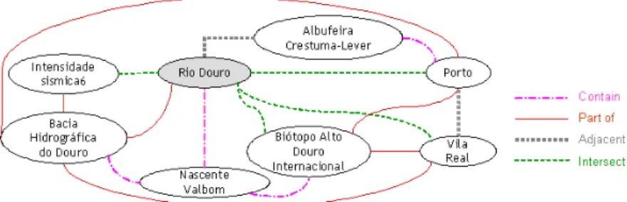
Figure 6 shows some instances of the concepts in Figure 5. It is pos-sible to observe the multiplicity of relationships between features. It de-scribes the geo-physical relationships for the Rio Douro, which is adjacent to Albufeira Crestuma-Lever. It also intersects four features: two from the geo-physical domain (Intensidade S´ısmica 6 and the Bi´otopo Alto Douro Internacional), and two from geo-administrative domain (the municipalities of Porto and Vila Real). The latter are examples of inter-domain
relation-Figure 6.Excerpt of the inter-domain relationships among some geo-physical instances in GKB 2.0.
ships. The Rio Douro is also related to other physical instances, which have been omitted for the sake of clarity and space.
5
Publishing GKB contents for Semantic Web
Applications
Once integrated in GKB 2.0, geographic knowledge can be exported in OWL, the Semantic Web format, for use by applications working with geographic in-formation. Considering the different needs in the Semantic Web environment, generated ontologies may be organized in different ways. GKB 2.0 may export its stored knowledge with multiple data-structure organizations, corresponding to different visions of the information. It is possible, for example, to generate name-centered or feature-centered views. A named entity recognizer requires a name-centered representation for names look-up, whereas GIS applications are probably more interested in a loading of features satisfying some criteria and their associated attribute.
A name-centered view allows an application to know, for example, how many types a name is related to faster than with a feature-centered view. On the other hand, the feature-centered view enables the capture of the information (e.g., relationships, attributes and footprints) related to every single feature easier than with a name-centered representation.
Figure 7 presents an excerpt of the name-centered OWL format descrip-tion of the geo-administrative name Lisboa. Lisboa is a preferred name (gn:att=“P”) provided by the INE information source (gn:is=“INE”) and has two other names. Lissabon is an alternative name (gn:att=“A”) in German and Olissipo is its historic name (gn:att=“H”). The Wikipedia information source provides both names. Lisboa is also the name of different feature types. It may be a province (PRO), a municipality (CON), a street (RUA) and an avenue(AVE), among others.
The geographic knowledge output in OWL ontologies reflects the classes, relationships and the cardinality in the model described along the Section 3. The OWL sub-language used here is OWL-Lite. The restrictions of OWL-DL and OWL-Full are still not necessary in our representation. This fact allows any OWL reasoner handle the generated ontologies.
<gn:Geo-Name rdf:ID="GEO_ADM_30"> <gn:names>
<rdf:Bag>
<rdf:li gn:name="Lisboa" xml:lang="PT-PT" gn:att="P" gn:is="INE"/> <rdf:li gn:name="Lissabon" xml:lang="DE-DE" gn:att="A" gn:is="WIKI"/> <rdf:li gn:name="Olissipo" xml:lang="EL-GR" gn:att="H" gn:is="WIKI"/> </rdf:Bag> </gn:names> <gn:geo_type_id rdf:resource="#PRO"/> <gn:geo_type_id rdf:resource="#CON"/> <gn:geo_type_id rdf:resource="#RUA"/> <gn:geo_type_id rdf:resource="#AVE"/> </gn:Geo-Name>
Figure 7.An excerpt of a name-centered OWL representation from GKB 2.0. <gn:Geo_Feature rdf:ID="GEO_PHY_145">
<gn:names> <rdf:Bag>
<rdf:li gn:name="Douro" xml:lang="PT-PT" gn:att="P" gn:is="IGeoE"/> <rdf:li gn:name="Duero" xml:lang="ES-ES" gn:att="A" gn:is="IGP"/> </rdf:Bag>
</gn:names> </gn:Geo_Feature>
Figure 8.An excerpt of a feature-centered OWL representation from GKB 2.0. Figure 8 gives an excerpt of geographic names and attributes exported from a GKB 2.0 model to an OWL ontology. The feature GEO PHY 145 is describing the names and attributes for the Douro river. The GEO PHY prefix represents features from physical domain whereas the GEO ADM prefix encodes the features from administrative domain. The Douro river has a preferred name Douro in Portuguese PT-PT and an alternative name Duero, in Spanish ES-ES. Each name is associated with an information source. The first is provided by IGeoE whereas the second one is given by IGP.
Figure 9 shows an excerpt of how the feature types are represented in OWL. The excerpt describes the details about the Douro river. The type Rio and its attributes are provided by IGeoE. The source of Douro river is represented by the element source river with a internal link to the feature, which has the identifier GEO PHY 120(Serra de Urbi˜ao in Spain). The outlet of the river is GEO ADM 238 (municipality of Porto). Its tributaries are in number of 10, but Figure 9 just illustrates two of them, whose identifiers are GEO PHY 400 (Paiva river) and GEO PHY 401(Sousa river). The length of the Douro river is 850 km.
Figure 10 shows examples of the relationships involving the Douro river. The Douro river intersects the municipality of Porto (GEO ADM 238) and the Ribeira da Granja river (GEO PHY 300). In addition, the Douro river is adjacent to Albufeira do Carrapatelo (GEO PHY 198) and is part-of the Bacia Hidrogr´afica do Douro (GEO PHY 100). In this case, the intersects
<gn:geo_type_id gn:is="IGEO" rdf:resource="#Rio"/> <rdfs:comment>Serra de Urbi~ao - Spain</rdfs:comment> <gn:source_river gn:is="IGEO" rdf:resource="#GEO_PHY_120"/> <rdfs:comment>Porto - Portugal</rdfs:comment>
<gn:outlet_river gn:is="IGEO" rdf:resource="#GEO_ADM_238"/> <gn:tributary gn:is="IGEO"> <rdf:Bag> <rdf:li rdf:resource="#GEO_PHY_400"/> <rdf:li rdf:resource="#GEO_PHY_401"/> </rdf:Bag> </gn:tributary>
<gn:length unit="km" gn:is="IGEO">850</gn:length>
Figure 9.An excerpt of types and its attributes in OWL in Geo-Net-PT02. <rdf:Bag> <rdf:li> <gn:Geo_Relationship> <gn:rel_type_id rdf:resource="#INTERSECTS"/> <gn:geo_id> <rdf:Bag> <rdf:li rdf:resource="#GEO_ADM_238"/> <rdf:li rdf:resource="#GEO_PHY_300"/> </rdf:Bag> </gn:geo_id> </gn:Geo_Relationship> </rdf:li> <rdf:li> <gn:Geo_Relationship> <gn:rel_type_id rdf:resource="#ADJ"/> <gn:geo_id rdf:resource="#GEO_PHY_198"/> </gn:Geo_Relationship> </rdf:li> <rdf:li> <gn:Geo_Relationship> <gn:rel_type_id rdf:resource="#PRT"/> <gn:geo_id rdf:resource="#GEO_PHY_100"/> </gn:Geo_Relationship> </rdf:li> </rdf:Bag>
Figure 10. An excerpt of relationships between administrative and geo-physical domains in OWL in Geo-Net-PT02.
relationship was generated from coordinates, since it is not explicitly represented in GKB 2.0.
Finally, an other important characteristic of GKB 2.0 is that information can also be partially exported. Applications using ontologies generated by GKB 2.0 may have interest only in parts of its contents. For example, one may be
inter-ested only in the generation of features containing just historic names, features associated with types above a specific degree of granularity (e.g., localities or streets) or features provided from specific information sources.
Geo-Net-PT02 intends to be a reference for geographic information process-ing on the Portuguese territory, providprocess-ing a large (wide and deep) coverage of concepts and instances. Geo-Net-PT01 filled this need for the geo-administrative domain whereas Geo-Net-PT02 is going to be enriched with geo-physical data, coordinates and multilingual names for features.
6
Related Work
Other works dealing with an environment to integrate and export ontologies are often in the scope of private companies or public initiatives. In both cases details about the construction of the resources are omitted or really do not exist. Two geographic information resources that are available for free or at a nominal license fee are the Getty Thesaurus of Geographic Names (TGN) [11] and Geonames (geonames.org).
TGN is a structured vocabulary including names and associated information about both current and historical wide-world places. Details about the construc-tion of this resource are not available and the data-integraconstruc-tion procedure is also unknown to us. TGN contains about 1 million places over the world, including both political entities (e.g. nations) and physical features (e.g. rivers) [12]. How-ever, TGN lacks detailed information about Portugal (notoriously some of the most important street names).
Geonames is a large public geographical database, which contains a world-wide list of geo-administrative and geo-physical names. For Portugal, it has just 23,503 names in both domains. Historic feature types and names for Portugal (e.g., provinces) are also not provided by Geonames. Considering just the ad-ministrative domain, Geo-Net-PT01 has 34,519 distinct names for the geographic types above the level of localities (not including streets names) [13]. This leads us to conclude that the coverage of names supported by Geonames is very limited for Portugal.
7
Final Remarks
This article described ongoing work about the new version of GKB, detailing the data model and ontology format for the exported data. The model enables the generation of geographic ontologies representing knowledge integrated from geo-administrative and geo-physical domains. We also showed different ways for publishing GKB contents for Semantic Web applications, facilitating their parsing. Future work includes the processing (Extraction, Transformation and Loading (ETL)) of geographic data covering the physical domain and generation and release of Geo-Net-PT02.
Acknowledgements
Marcirio Chaves is member of the XLDB Node of Linguateca supported by grant POSI/PLP/43931/2001 from FCT, co-financed by POSI. This work is supported by grant POSI/SRI/47071/2002 (GREASE) from FCT, co-financed by POSI.
References
1. Schmidt, D.C.: Model-driven engineering. IEEE Computer 39(2) (February 2006) 25–31
2. Chaves, M.S., Silva, M.J., Martins, B.: GKB - Geographic Knowledge Base. DI/FCUL TR 05–12, Departamento de Inform´atica da Faculdade de Ciˆencias da Universidade de Lisboa (July 2005)
3. Chaves, M.S., Silva, M.J., Martins, B.: A Geographic Knowledge Base for Semantic Web Applications. In Heuser, C.A., ed.: Proc. of the 20th Brazilian Symposium on Databases, Uberlˆandia, Minas Gerais, Brazil (October, 3–7 2005) 40–54 4. Freitas, S., Afonso, A.P., Silva, M.J.: Mobile Geotumba: Geographic Information
Retrieval System for Mobile Devices. In: Proc. of the 4th MiNEMA Workshop, Sintra, Portugal (July, 2-3 2006) 83–87
5. Silva, M.J., Martins, B., Chaves, M.S., Cardoso, N., Afonso, A.P.: Adding Geo-graphic Scopes to Web Resources. CEUS - Computers, Environment and Urban Systems - Elsevier Science 30(4) (July 2006) 378–399
6. Cardoso, N., Martins, B., Chaves, M.S., Andrade, L., Silva, M.J.: The XLDB Group at GeoCLEF 2005. In Peters, C., Gey, F.C., Gonzalo, J., M¨uller, H., Jones, G.J.F., Kluck, M., Magnini, B., de Rijke, M., eds.: Accessing Multilingual Information Repositories, 6th Workshop of the Cross-Language Evalution Forum, CLEF 2005, Vienna, Austria, 21-23 September, 2005, Revised Selected Papers. Volume 4022 of Lecture Notes in Computer Science., Springer (2005) 997–1006
7. Chaves, M.S., Santos, D.: What kinds of geographical information are there in the portuguese web? In Vieira, R., Quaresma, P., da Gra¸ca Volpes Nunes, M., Mamede, N., Oliveira, C., Dias, M.C., eds.: Proc. of the 7th Workshop on Computational Processing of Written and Spoken Portuguese, PROPOR 2006. Volume 3960 of Lecture Notes in Computer Science., Itatiaia, Rio de Janeiro, Brazil, LNAI 3960 -Springer (13th - 17th May 2006) 264–267
8. ISO - International Organization for Standardization: ISO 19109:2005 Geographic information – Rules for application schema. 1 edn. (June, 23 2005)
9. van Gigch, J.P.: System Design Modeling and Metamodeling. First edn. ISBN: 0306437406. Springer, New York (July 1991)
10. Alvestrand, H.: Request for Comments: 3066 - Tags for Identification of Lan-guages. http://www.ietf.org/rfc/rfc3066.txt (January 2001) Accessed in Jan-uary 2007.
11. TGN: Getty Thesaurus of Geographic Names. www.getty.edu/research/ conducting_research/vocabularies/tgn/ Accessed in January 2007.
12. Martins, B., Silva, M.J., Chaves, M.S.: Challenges and resources for evaluating ge-ographical IR. In: Proc. of the 2nd Workshop on Geographic Information Retrieval at CIKM, Bremen, Germany (November 4th 2005) 65–69
13. Santos, D., Chaves, M.S.: The place of place in geographical IR. In: Proc. of the 3rd Workshop on Geographic Information Retrieval, SIGIR’06, Seattle, USA (August 10th 2006) 5–8