AERIAL IMAGES TAKEN BY UAV:
Laxmi Thapa
SHIP RECOGNITION ON THE SEA SURFACE USING
AERIAL IMAGES TAKEN BY UAV:
A Deep Learning Approach
Dissertation supervised by:
Professor Victor José de Almeida e Sousa Lobo, PhD
Portuguese Naval Academy
Instituto Superior de Estatística e Gestão de Informação,
Universidade Nova de Lisboa
Lisbon, Portugal
Assistant Professor Mauro Castelli, PhD
Instituto Superior de Estatística e Gestão de Informação,
Universidade Nova de Lisboa
Lisbon, Portugal
Joaquín Torres-Sospedra, PhD
Institute of New Imaging Technologies,
Universitat Jaume I Castellón de la Plana, Spain
I would like to extend my sincere gratitude and appreciation to supervisor Prof Dr. Victor Lobo for his persistent support, motivation and supervision. His continuous encouragement and flexible working practices had always created favorable research environment along with his constructive suggestions and guidance always orienting me towards right direction in thesis. He was not only helping on my research but had also been caring whether I am living comfortably in Lisbon. Thank you so much for inspiring me to live an organized life during this six months!
My deep appreciation and gratefulness are also to supervisor Professor Dr. Mauro Castelli for always standing and helping in coping with the challenges I had to faced during thesis period; thank you so much for providing access to server for the high computational performances! Your guidance, critical comments and support through-out the research period have been among the main building blocks for coming through-out with this thesis work. Likewise, I am thankful to my co-supervisor Professor Joaquin Sospedra for his detailed constructive comments, valuable suggestions, motivation and useful resources for the research.
I am grateful to Professor Marco Painho for his productive comments and suggestions throughout this semester for conducting this thesis. You have always been proactive in solving every single issue troubling not only during the research work but also during the whole study period in Nova IMS. Likewise, I am thankful to Dr. Joel Silva for his valuable time for suggestions and support during the early days of thesis. Simi-larly, my sincere thanks to Erasmus Mundus Masters course and all three partnering universities for this wonderful opportunity to learn in a completely multi-cultural environment. Additionally, the administrative support received from Erasmus office and Academic services of NOVAIMS and IFGI always helped me in focusing more on the studies. Thank you to all these welcoming people for making my international life easier!
I am equally thankful to all the friends of this masters course for your awesome com-pany. What an amazing family we all have become now! Also, this last semester with the Lisbon Originals-Arman, Roberto, Nicodemus, Duarte, Mitzi, Stefana and William, had really been the most connected one. The whole thesis period had only been easy with your crazy company filled with high motivation, jokes and smiles no matter how bad was the situation. Kudos to you all!
I am also thankful to my friends Shrijana Panta, Sanjeev, Eliza, Sainju, Jyoti, Man-isha and everyone who had been continuously cheering me during this international studies and, had been helping directly and indirectly for completing the course. Also, Thank you Sanjeevan dai, Kushal Ang and Manish for the last minute help on proof reading and improving this document.
I have no words to express respects and love to my family; my emotional but coura-geous mother for her unconditional love, dedication and exceptional patience to make
me and, all of us in the family always connected, my father and sister who always listened my studies and research progress even without understanding a single word, brother in law, Hari for always standing with me, brothers- Santosh for always being accountable to me and whole family (your proof reading has been very helpful), and Amrit for your critical thoughts on my research and always encouraging me to study, nephews-Darpan and Darsish for refreshing me with their smiled filled talks every time. Though I am physically far, your emotional support, motivation and faith on me have always inclined me towards studies. This thesis is dedicated to this amazing family of mine.
AERIAL IMAGES TAKEN BY UAV:
A Deep Learning Approach
ABSTRACT
Oceans are very important for mankind, because they are a very important source of food, they have a very large impact on the global environmental equilibrium, and it is over the oceans that most of the world commerce is done. Thus, maritime surveillance and monitoring, in particular identifying the ships used, is of great importance to oversee activities like fishing, marine transportation, navigation in general, illegal border encroachment, and search and rescue operations. In this thesis, we used images obtained with Unmanned Aerial Vehicles (UAVs) over the Atlantic Ocean to identify what type of ship (if any) is present in a given location. Images generated from UAV cameras suffer from camera motion, scale variability, variability in the sea surface and sun glares. Extracting information from these images is challenging and is mostly done by human operators, but advances in computer vision technology and development of deep learning techniques in recent years have made it possible to do so automatically. We used four of the state-of-art pretrained deep learning network models, namely VGG16, Xception, ResNet and InceptionResNet trained on ImageNet dataset, modified their original structure using transfer learning based fine tuning techniques and then trained them on our dataset to create new models. We managed to achieve very high accuracy (99.6 to 99.9% correct classifications) when classifying the ships that appear on the images of our dataset. With such a high success rate (albeit at the cost of high computing power), we can proceed to implement these algorithms on maritime patrol UAVs, and thus improve Maritime Situational Awareness.
KEYWORDS
Ship Recognition Classification UAV Images Deep Learning
Deep Convolutional Neural Networks Transfer Learning
Index Of Figures viii
Index Of Tables ix
Acronyms x
1 Introduction 1
1.1 Contextual Background . . . 1
1.2 Problem Statement and Motivation . . . 4
1.3 Research Aim and Objectives . . . 4
1.4 General Methodology . . . 5
1.5 Contribution . . . 5
1.6 Thesis Organization . . . 6
2 LITERATURE REVIEW 8 2.1 Related Works . . . 8
2.1.1 Sensors platform used for ship recognition . . . 8
2.1.2 Images used for sea object recognition . . . 9
2.1.3 Sea Surface Object Recognition Approach . . . 10
2.1.4 Improvements in Deep learning . . . 14
2.1.5 Network Architecture and their choices . . . 15
2.1.6 Transfer Learning . . . 17
2.2 Theoretical Frameworks and Terminologies . . . 18
3 DESCRIPTION OF DATA AND RESOURCES USED 26 3.1 Data Description . . . 26 3.2 Data Preparation . . . 27 3.3 Resources Used . . . 28 3.4 Data Exploration . . . 29 4 METHODOLOGICAL DESCRIPTION 31 4.1 Proposed Methodology . . . 31
4.2 Methodological Design and Implementation . . . 33
I N D E X O F T H E T E X T
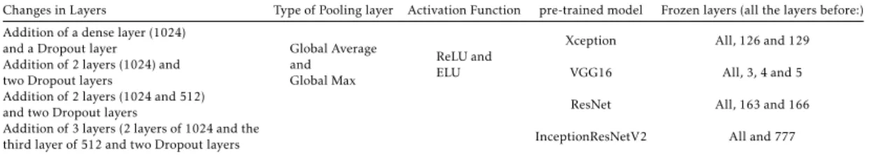
4.2.2 Modification and design of pre-trained Network model Architec-ture . . . 33 4.2.3 Optimization and Regularization with Hyperparameters . . . 35 4.2.4 Algorithm Design . . . 35
5 RESULTS AND PERFORMANCE EVALUATION 38
5.1 Visualization of Data Augmentation Technique . . . 38 5.2 Modification and design of pre-trained Network model Architecture . 38 5.3 Performance evaluation and comparison . . . 41
6 RESULTS DISCUSSION AND COMPARISON 45
6.1 Result Discussion . . . 45 6.2 Comparison with existing works . . . 47
7 CONCLUSION AND FUTURE WORKS 49
Bibliographic References 51
I ANNEX: Modification in Model Architecture 58
I.1 Modification Strategy of VGG16 . . . 58 II ANNEX 2: Accuracy-Validation Comparison with Hyperparameters 59 II.1 Training and Validation Accuracy with Xception Model . . . 59 II.2 Training and Validation Accuracy with InceptionResNetV2 Model . . 60 II.3 Training and Validation Accuracy with ResNet50 Model . . . 60
III ANNEX: Algorithm developed to run the model 62
1.1 Methodological Overview . . . 5
2.1 Drivers of Machine Learning success in industry . . . 18
2.2 Transfer Learning Techniques: feature extractor . . . 23
2.3 Transfer Learning Technique: Frozen and fine tuned layers . . . 24
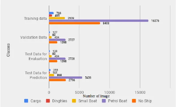
3.1 Distribution of data for different datasets . . . 29
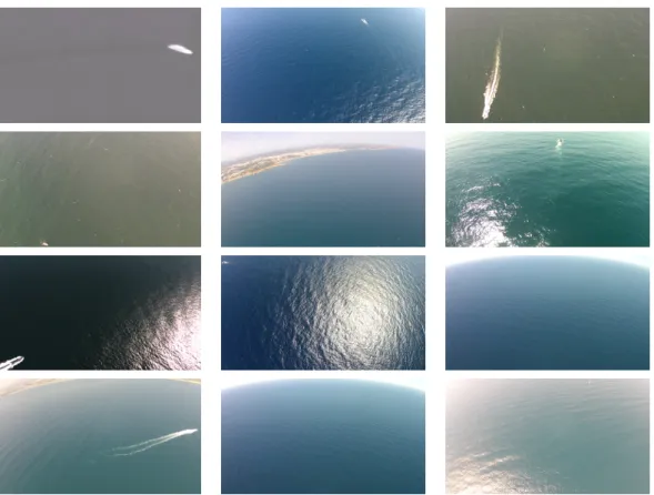
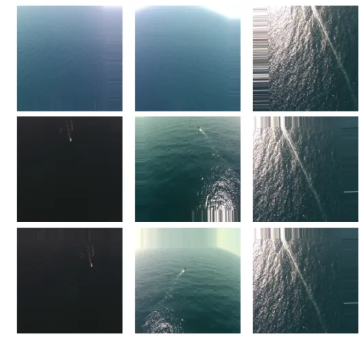
3.2 Images with varying background environments . . . 30
5.1 Images obtained with Data Augmentation Techniques . . . 39
5.2 Training and Validation Accuracy of the chosen models . . . 42
5.3 Training and Validation Loss of the chosen models . . . 42
5.4 Confusion Matrix of the proposed models . . . 43
5.5 Visualizing images with the ship classes using modified . . . 44
I.1 VGG16 Modification Strategy . . . 58
II.1 Accuracy and Loss obtained on Xception model while experimenting with different hyperparameters . . . 59
II.2 Accuracy and Loss obtained on InceptionResNetV2 model while experi-menting with different hyperparameters . . . 60
II.3 Accuracy and Loss obtained on ResNetV50 model while experimenting with different hyperparameters . . . 61
I n d e x O f Ta b l e s
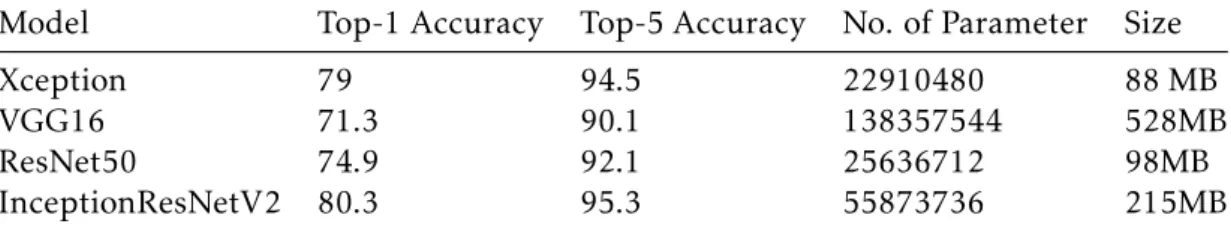
3.1 Data Description . . . 27 3.2 Data Preparation with image classes . . . 28 3.3 Data Distribution . . . 28 4.1 Accuracy of the models chosen in the study when trained on ImageNet
dataset (Accuracy is expressed in terms of %correction) (Source: Chollet, 2015) . . . 32 4.2 Modification strategies applied in the layers of existing network models . 35 4.3 Optimization and Regularization with Hyperparameters . . . 35 5.1 Changes in the number of layers and corresponding number of parameters 39 5.2 Models and their structure . . . 41 5.3 Comparison of Evaluation accuracy between different methods . . . 43
AIS Automatic Identification System. ANN Artificial Neural Networks.
AODN Accurate Object Detection Network. CFAR Constant False-Alarm Rate.
CNN Convolutional Neural Network.
COLREGs International Regulations For Preventing Collisions. CPU Central Processing Unit.
CRFs Conditional Random Fields. DFPN Dense Feature Pyramid Network. ELU Exponential Linear Unit.
FlIR Forward Looking Infrared. GEO Group On Earth Observation. GPU Graphical Processing Unit. HMM Hidden Markov Models.
HOG Histogram of Oriented Gradients. HSF Hierarchical Selective Filtering.
IACS International Association Of Classification Societies. ILSVRC Imagenet Large Scale Visual Recognition Challenge. IMO International Maritime Organization.
kNN k-Nearest Neighbors. LR Learning Rates.
AC R O N Y M S
LRIT Long-Range Identification And Tracking. MaxEnt Maximum Entropy.
MDA Maritime Domain Awareness.
MS-OPN Multi-Scale Object Proposal Network. MSA Maritime Situational Awareness.
NIR Near Infrared.
OBIA Object-Based-Image-Analysis. RADAR Radio Detection and Ranging. RAM Random Access Memory.
RCNN Regional Convolutional Neural Networks. RCPA Robust Principal Component Analysis. ReLU Rectified Linear Unit.
RNMS Rotational Non-Maximum Suppression. ROC Receiver Operating Characteristic.
SAR Synthetic Aperture Radar.
SC-RPCA Segmentation Constrained Robust Principal Component Analysis. SFM Structure From Motion.
SGD Stochastic Gradient Descent. SSD Single Shot Multibox Detector. SVM Support Vector Machine. TPU Tensor Processing unit. UAS Unmanned Aerial System. UAV Unmanned Aerial Vehicle. VMS Vessel Monitoring System. VOC Visual Object Classes.
C
h
a
p
t
1
I n t r o d u c t i o n
1.1
Contextual Background
The marine ecosystem has always been of interest to navigation agencies, countries and environmental agencies for activities like traffic management and safe navigation, border control, defense and national security, fisheries management, maritime spa-tial planning, marine pollution, irregular migration and maintaining balanced marine ecosystem (Hartemink, 2012), (Kanjir et al., 2018), (Liu et al., 2017a). Most human activities occur on the sea surface: transportation is done using ships of various types (Zheng et al., 2014); recreational activities will involve jet-skis, rubber boats, canoes, buoys, ships, swimmers or human bodies floating on its surface (Hartemink, 2012); the majority of fishery activities, that are prime source of food around the globe, is done with different types of ships; gas and oil explorations are another potentially valued economic activity that can be observed on the sea surface. Marine activities are con-tinuously increasing with the advancement in marine exploration, transportation, and thus induced economic benefits. However, such growing outreaches are reportedly accompanied with illegal, potentially jeopardizing and ecosystem-unfriendly activi-ties; haphazard fishing activities even in banned areas, oil spills on the sea surface, illicit monitoring over the coastal waters of countries are among such activities. Ad-ditionally, the maritime surface has even become the carrier of land-based debris like plastics, metals, glasses that are transported to the marine environment through dif-ferent acts like urban runoff, sewer overflow, industrial and littering activities (Ediang and Ediang, 2013). This debris is considered among the agents of marine pollution for putting real threats on health, biodiversity, and productivity of marine biota (Buhl-Mortensen and Buhl-(Buhl-Mortensen, 2017). Such coastal engagements characterized by both the beneficial and detrimental activities are driving the attention of the global
C H A P T E R 1 . I N T R O D U C T I O N
community. Various organizations like Group on Earth Observation (GEO), Inter-national Maritime Organization (IMO), European Maritime Safety Agency (EMSA), coastal bordered countries and academic institutions are closely monitoring, observ-ing and implementobserv-ing various systems for the betterment of the maritime environment. Activities to understand maritime environment have been termed as Maritime Domain Awareness (MDA) (Valavanidis and Vlachogianni, 2012), (Hartemink, 2012) or Mar-itime Situational Awareness (MSA) for more localized picture. MDA and MSA require heterogeneous information (Kanjir et al., 2018) and rely on object monitoring and detection. The most dominant objects over the sea surface used either as the means of carriers for transportation, fishing, surfing, rescue operation, monitoring or supervi-sion are ships or vessels.
Ships are categorized in different types and classes based on the design, constructional structure, and purpose of their usages. These classifications help in ship identification, safety management, and maritime traffic control. Various classification societies are established in different coastal regions and countries that issue classification certifi-cate for the ships with the aim of maintaining maritime safety by setting the technical standards and rules for designing, constructing and maintaining ships. International Association of Classification Societies (IACS) formed as a non-profit membership or-ganization of classification societies is among such actively engaged societies that is technically supporting IMO in its maritime research and development and has even set up compliance rules and standards for vessel classification design and construc-tion along with its twelve of the member societies. Addiconstruc-tionally, IMO has published International Regulations for Preventing Collisions at Sea 1972 (COLREGs) that gov-erns ships with common and consistent navigation rules internationally depending upon their classes. Also, the European Code for Navigation and International Sailing Federation is actively working for safe maritime navigation. So, maritime surveillance that basically involves identifying ships on the sea surface, recognizing their classes, monitoring and tracking them visually can be crucial in knowing the activities ships are conducting and intentions of their usage thereby supporting better navigation, controlling illegal activities and detecting oil spills (Gallego et al., 2018).
Environment monitoring and surveillance has been one of the potential applications of remote sensing for the high resolution, qualitative data it provides through space-borne and airspace-borne sensors system (Li et al., 2018). The Landsat Satellites in 1977 followed by Synthetic Aperture RADAR (SAR) in 1978 through to the first SeaSat Satellite are milestones in earth observation including marine surfaces. Based on the globally followed regulations, different systems like Automatic Identification System (AIS) for short-range operation, Long-Range Identification and Tracking (LRIT), Ves-sel Monitoring System (VMS) are widely used automatic reporting systems for the ships/vessels. But, not all ships and fishing vessels, especially those with less than 300 tons, are mandated for these systems and there have been cases reported of not using or spoofing the reports to mask illegal activities (Kanjir et al., 2018). Besides,
these systems are designed for a specific purpose like communication transmission or monitoring only the fishing vessels. The weather independent features of SAR provid-ing day-night cloud-free images from RADAR signals have been used widely for ship monitoring and detection. But, it has limitations with low visit time and a smaller number of operational SARs due to the high cost associated with it. Space deployed satellites with higher (commercial) and lower (free) spatial resolutions are available in abundance with wide area coverage over the coastal surface. However, weather dependency and data capturing based on their rotational time and higher computa-tional cost associated with the continuous observations constitute restrictions. The improvements in sensor technology and unmanned aerial vehicles with sophisticated hardware and battery offering longer performing capacity are making them alternative solutions for the surveillance and data capturing tasks requiring low area coverage with higher spatial resolution at an affordable cost. Nowadays, UAVs are widely used in different fields like urban planning, natural disaster assessment, traffic manage-ment, surveillance activities for security and safety around the globe, including all the surfaces - airspace, land and marine environment (Li et al., 2018). The flexibility of integrating need-based sensor systems like optical or thermal, on-demand usability and the easy autonomous operation supporting emergency situations like search and rescue are additionally supporting their use in the maritime environment.
The increasing use of aircraft and unmanned vehicle systems for monitoring sea sur-faces have produced a huge amount of data and images with detailed information about the earth surface. Monitoring these image data manually and extracting useful information has become difficult using traditional handcrafted methods because of the need for real-time or near real-time performances with high accuracy. Different machine learning and deep learning techniques have been developed to ease automatic feature extraction, object classification, recognition, and detection. Machine learning techniques have involved shallow architectures with one layer for feature transfor-mation and are effective for simple well-defined problems (Deng, 2012). But the real-world applications like ship classification and recognition from optical images having background features like light illuminance and waves require deeper struc-ture capable of learning and extracting feastruc-tures properly with high accuracy. Deep Learning has emerged as a solution in this context allowing multilayer hierarchical architectures for feature learning, classification and pattern recognition. Convolu-tional Neural Networks (CNNs) are one of the Deep Learning techniques renowned for their outperforming image classification accuracy since the start of this decade, and is continuously advancing with the availability of higher computational power and graphical processing units (GPUs). But, requirements of larger datasets for training in a sophisticated computing environment is still hindering its usability to capacitate common individual researcher at ground level. The concept of transfer learning has been materialized as an alternative to combat these challenges; it involves transferring the learnings obtained by training the chosen network model on large datasets applied
C H A P T E R 1 . I N T R O D U C T I O N
for different usages to another application of similar nature with less dataset.
This thesis focuses on classification and recognition of ships contained in images gen-erated from videos captured by UAVs using Deep Learning with Convolutional Neural Network and transfer learning. The video datasets obtained from Seagull Project taken over different areas of the Atlantic Ocean are the primary sources of image sequences.
1.2
Problem Statement and Motivation
Most of the research on marine ship monitoring involves extraction and classifica-tion of image features using different shallow structure algorithms like Histogram of Oriented Gradients, exemplar Support Vector Machine (Chua et al., 2014) eigen-value analysis with principal component analysis (Pietkiewicz and Matuszewski, 2018). These techniques are lacking the demanding accuracy and, even if achieved are at the cost of performances and more workloads in terms of parameters. But, advancement in computer vision technology and development of deep learning techniques, particu-larly convolution neural networks (CNNs) has been offering remarkable performances in the field of image recognition with strong feature learning ability, fewer model train-ing parameters and high recognition accuracy (Kumar and Sherly, 2017), (Wang et al., 2018). Among some researches done in a maritime environment using CNNs, most are done either with SAR Data or satellite-based optical images (Tang et al., 2015) with more focus on detection than the recognition. In case of classification also, these are performing binary classification like Gallego et al., 2018 to identify if ship is present or not. Very few researches are done using CNNs with UAS captured data; Moreover, data used are normally taken in similar environmental conditions with the same sen-sors. Even at these scenarios, the primary challenges for the videos and images taken with UAS over the sea surface are characterized with scale variability, movements of UAVs, wave crests and sun glare difficult to identify ships based on their size, shape or textures (Ribeiro et al., 2017). So, the novelty of this thesis lies on exploring the potentialities of deep learning that have been put forward with deep CNNs in image classification and recognition scenarios to recognize the class of ship from images gen-erated by the videos captured by different visible and infrared sensors deployed with UAS over different areas of Atlantic Ocean in different time period.
1.3
Research Aim and Objectives
The aim of this thesis is to perform multi-classification of ships and their recognition by training deep convolutional neural networks on the aerial images captured by UAS over the sea surface using the concepts of transfer learning. To achieve this main aim, specific objectives have been set as follows:
• Review existing state of art on the sea objects classification, recognition, deep learning, CNNs and transfer learning.
• Choose suitable Deep CNN architecture and pre-trained weights, design and implement algorithms using transfer learning techniques for multi-classification of ships and their recognition.
• Performance evaluation and review of the proposed approach with the existing approaches.
1.4
General Methodology
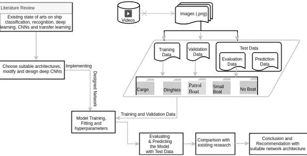
The schematic diagram 1.1 below provides an overview of the overall methodology applied in this thesis. It basically involves reviewing existing works and determining suitable deep learning methods for image recognition along with its parameters and then using the identified methods with suitable modification to recognize ships present in images with their respective classes. Lastly the model obtained from modification will be evaluated using different approaches like precision-recall rate and confusion matrix. Detail methodological description about the methods adopted can be found at Chapter 4.
Figure 1.1: Methodological Overview
1.5
Contribution
This thesis will use deep learning to address the current gaps and challenges men-tioned in section 1.2 for recognizing ships on the sea surface. The main contribution of this thesis consists of:
C H A P T E R 1 . I N T R O D U C T I O N
• Exploring the possibilities of using deep learning for recognizing ships on im-ages generated from a non-static UAV mounted with camera having Visible and Infrared sensors.
• Proving that the final model trained on the thesis dataset can be used as a product to make predictions or to recognize ships present in images.
1.6
Thesis Organization
This thesis consists of seven chapters describing the entire activities carried out to complete it. Chapter 1 entails foundation of thesis starting with the first section brief-ing about contextual background on the need for ship monitorbrief-ing and recognition followed by the existing platforms and techniques used for this purpose. It further highlights the need for classifying ships, existing methods, and techniques used for classification and gives a short description of this thesis work; second subsection men-tions about the underlying gaps in existing research on the ship classification and recognition followed by the challenges this thesis has taken using the Seagull data; it also mentions briefly about the proposed method of CNNs; the third subsection states the main aim of this thesis along with the specific objectives set to achieve it; subsection four gives an overview of the proposed methodology defined to achieve the research aim and objectives formed through contextual background and problem statement.
Chapter 2 consists of a literature review explained with the related work on the thesis in the first part and afterward contains theoretical definition and description of the terms, terminology, and methods used throughout the thesis.
Chapter 3 explains the detail information about dataset used in this thesis by describ-ing the source of data and platform used for data collection. It further describes how data has been compiled and prepared to suit the methodology requirement of this thesis. It also describes resources used in this thesis including both the software and hardware.
Chapter 4 puts forward the idea of the methodology proposed based on the literature review with related work having the start of art performances to achieve the aims and objectives set in Chapter 1. Its latter section describes in detail the chosen architecture and its modification with suitable parameters and hyperparameters. It also describes the designing of the algorithm developed for the thesis.
Chapter 5 showcases results and briefly mentions the results. It also evaluates the accuracy obtained along with network performances, computational power and time required for the model´s execution.
Chapter 6 discusses the significance of results. It further presents the comparison of this thesis with the similar works done before and presents the differences between these methods and distinction of proposed method with them.
Chapter 7 explains the conclusion obtained from this thesis together with the limita-tions and recommendalimita-tions for future works.
The content afterward consists of Annexes I to supplement the contents described shortly in the main chapters for page limitation.
C
h
a
p
t
e
r
2
L I T E R AT U R E R E V I E W
This section consists of comprehensive review on existing state of art on the object recognition techniques for sea surface based on the existing research and projects. The first part starts with background on the importance of sea surface monitoring and, objects detection followed by the platforms and tools used for these tasks. The sec-ond part discusses the conventional approaches used for sea surface object detection starting with the satellite images and then UAS images The third part presents about deep learning techniques, particularly Convolutional Neural Networks and different techniques used on CNNs for the better performances and accuracy used for the detec-tion. The fourth and last part explains the theoretical definition and insights on deep learning, CNNs, and other the technical terms used in the research.
2.1
Related Works
2.1.1 Sensors platform used for ship recognition
Different sensors have different features that determine their applications; spatial resolution, update rate, range, coverage, persistence, latency, and cost are among the major concern. The most widely used sensors in marine surveillance are optical, infrared and radars deployed either on satellites, aircraft/UAS, ships or shores (Kanjir et al., 2018). Radar is the typical technology for monitoring and detecting ships that is in use since the 1990s; Synthetic Aperture Radar (SAR) is one of the most popular and widely used maritime monitoring and detecting Radar techniques for its ability to capture images independent of weather and daylights. It is even independent of the distance to the observed object. However, SAR has the limitations of being highly prone to intrinsic noise, low spatiotemporal coverage with limited number of satellites, long revisit cycle because of a smaller number of SAR satellites, difficulty to detect
small objects (Liu et al., 2017a) and, recognition of false alarms leading to difficulties in classification (Kanjir et al., 2018). Satellite-based sensors are popularly used for the wide area accessibility, remote access, systematic monitoring of data continuously, and availability of larger data collection (Kanjir et al., 2018) for time series analysis. Landsat, SPOT, QuickBird, IKONOS, Google Earth are among the highly used satellite sensors for maritime object recognition (Kanjir et al., 2018). The free availability of Sentinel-1 and Sentinel-2 optical satellites being operated under European Space Agency Earth Observation Missions1 has further increased the potential market of optical satellites.
For the usability on demand basis like emergency search and rescue, advancements in microelectronics (Bejiga et al., 2017), easily transportable, economically affordable and improvements in sensors technology and battery system for the integration with UAS system to achieve desired data resolutions for longer duration, applications of UAV-based sensors have increased extensively in the recent decades. Development of autonomous operating system offering many automatic facilities like flight take-off and landing, aerial refueling and route planning with higher levels of accuracy (Al-Kaff et al., 2018) have induced the concerned service providers and users to apply UAVs as the mundane means for navigation and surveillance activities. Also, sea surface monitoring and vessel detection from UAVs are increasing rapidly and so are the research on these fields growing (Dolgopolov et al, 2017, (Xu et al., 2014). Johnston, 2019 has discussed that UAVs have been used significantly in studying marine wildlife particularly for large marine creatures like whales, sea turtles, sharks.
2.1.2 Images used for sea object recognition
Hyperspectral sensors are the emerging remote sensing technology that uses imaging spectrometer to extract spectral information of a spatial area but possesses low spatial resolution when observed from orbit and involves complex processing. So, sea surface object detection, even the ship is difficult to detect from these images though there is less research done for its application in maritime (Kanjir et al., 2018), (Wang et al., 2016). Thermal infrared sensors used normally for night time image capture obtain emission from captured objects themselves unlike depending on solar illumination (Kanjir et al., 2018) whereas if used during the day, objects are detected based on the temperature differences between sea and surface objects (Wang et al., 2016). These sen-sors have the limitation of low resolution when measured from satellites and, suffers from atmospheric clouds and moisture when measured from the atmosphere. Optical images observed in the visible spectrum are easily detectable by the human eye; photos captured from a normal camera are also optical images. These images are consistent and enriched with essential information for feature extraction (Kadyrov et al., 2013) (Kanjir et al., 2018) including vessel detection and classification for economical price
C H A P T E R 2 . L I T E R AT U R E R E V I E W
and simplicity in structure (Lan and Wan, 2009). Further, these images offer high spatial and spectral resolution useful for detecting smaller objects (Pegler et al., 2007) though are greatly affected by weather and sun reflection on the water (Kanjir et al., 2018). There have been increasing trends in mounting video cameras and different sensors with aircraft and UAS, even on buoys or on floating platforms as these offer easy installation and maintenance (Kanjir et al., 2018); object detection in a such sys-tem involves the analysis of the images taken separately or the image frames generated from the videos and, are the data of interest for this research.
2.1.3 Sea Surface Object Recognition Approach
The object recognition process on sea surface involves mainly detecting the objects in the images, often referred as feature extraction and distinguishing the extracted fea-tures by discriminating them with water on the sea as non-water objects and assigning the class of the object, referred as object classification (Nie et al., 2017). The contents below initially present the traditional object recognition methods followed by modern approach of deep learning for classification and recognition.
The most widely used and researched sea surface objects detection methods use SAR images that involve the use of algorithms like constant false-alarm rate (CFAR) detector with the combination of Gauss distribution, k-distribution, and Gamma distribution or their individual uses (Liu et al., 2017a) for the feature extraction. Object detection from optical images in the past involved traditional handcrafts methods involving manual feature extraction from images based on shapes, textures and physical proper-ties. The first research according to Kanjir et al., 2018 on ship detection was done by McDonnell and Lewis, 1978 using the Landsat imagery; McDonnell and Lewis, 1978 inspected Landsat CTT printouts and put forward a threshold-based approach of de-tecting the ships by using total pixel numbers occupied by the ships in the MSS band, orientation of these pixels, their maximum and total pixel radiances values. Since then, many research have been carried out for ship detection using different methods; Kanjir et al., 2018 has reviewed 117 papers for optical satellite images, some of the methods are mentioned below: 1993 used transform domain method with high/low pass fil-ter on SPOT XS and Landsat TM images; ship detection based on shape and texture were used with different considerations like local image statistics with spatiotemporal features (Pegler et al., 2007), shape constraints (Wang et al., 2016), spatio-spectral template enhanced with weighted Euclidean distance metric (Pegler et al., 2007), cu-mulative projection curve with Mahalanobis distance (Hu and Wu, 2008), region based, shape-prior segmentation, mathematical morphology (Zhu et al., 2010), local binary patterns (Ji-yang et al., 2016), object-based image analysis (Li et al., 2016); this method though is enriched with spectral information with good accuracy for object detection suffers the issues of false alarm candidates. The threshold based method is used in dif-ferent ways like histogram-based segmentation, canny edge and Fourier transform (Hu
and Wu, 2008), (Li-xiaa et al., 2010) hierarchical clustering merging algorithm (Hong et al., 2007), adaptive threshold segmentation ((Hu and Wu, 2008) component tree image algorithm (Xu et al., 2011), (Zuo and Kuang, 2011), (Guo and Zhu, 2012) these are suited mostly for the smooth sea surface. Salient based methods like multiscale enhancement method (Li et al., 2016), hypercomplex frequency domain and phase quaternion fourier transform (Li et al., 2016), histogram-based contrast method (Liu et al., 2017b) are good for heterogeneous sea surfaces but may not be the good option in presence of high clutter on the image as it can lead to false alarm. Other methods like statistical though is quick result generative, it needs a good knowledge of the tools being used; transform domain method is not the good choice for high heterogeneity; anomaly detection methods are good for threshold and sea surface heterogeneity cases but shows bad performances for the near coastal ships.
Other sea surface objects have also been detected and an airborne system like aircraft or UAVs are normally integrated with electro-optical sensors having visible, infrared or hyperspectral spectrum cameras to capture the videos or images. The similar ap-proaches like that of optical satellite imagery and or with some developments and cus-tomization have been used for recognition purposes. Also, earlier days of UAS object detection were facilitated with computer vision techniques to some extent. Borghgraef et al., 2010 discusses problems associated with background subtraction algorithm and showed out performances by the algorithms like behavior subtraction and ViBe for detecting floating objects, particularly free-floating mines on the sea surface. Zheng et al., 2014 applied saliency detection method with Locally Adaptive Regression Ker-nels using self-resemblance techniques. Shin et al., 2016 presents the objects detection method that involves a coarse-to-fine resolution approach by customizing the stereo-vision based techniques and top-view grid method. Ventura et al., 2018 used open software-based structure-from-motion (sfm) techniques for orthomosaics followed by multi-resolution segmentation algorithm and spectral difference segmentation algo-rithm for Object-based-image-analysis (OBIA) in the commercial software for coastal mapping and classification. Seymour et al., 2017 used threshold method with high pass filter in ArcGIS model builder programming environment to detect seals in ther-mal imagery from fixed-wing UAS; this model used preprocessed rectified images and is suitable only for the images having single species. Leira et al., 2015 applied simple edge detector techniques for detecting the marine objects from the thermal imaging camera on a low-cost fixed-winged UAV and nearest neighbor classifier was applied for classification considering object size, temperature, and overall structure. These methods require a higher extent of human inputs and good computational skills and platforms.
Developments in computer vision technology and machine learning algorithms have increased the level of automaticity in object detection and classification with high per-formances; methods like co-training model (Guo et al., 2015), random forest method (Huang et al., 2015), sparse representation and Hough voting (Yokoya and Iwasaki,
C H A P T E R 2 . L I T E R AT U R E R E V I E W
2015), rotation and scale invariant method (Lin et al., 2017), Line segment detector Yao et al., 2016 have been used previously for these purposes (Kanjir et al., 2018). Prasad et al., 2016 presents the challenges like presence of occlusion, orientation, scale, va-riety of objects and their motion patterns along with the variations in weather and illumination condition associated with the maritime image processing from videos generated from cameras; they also discussed briefly the background object detection using Gaussian mixture, Gaussian background model and self-balancing sensitivity patterns analysis. Yu et al., 2015 proposed the context-driven Bayesian saliency model for detecting small and dim objects on FLIR images having sea clutter. These methods usually involve preprocessing tasks with the object features definition. Besides, these machine learning techniques offer the non-linear feature transformations, only for a single layer.
However, these methods including, hidden Markov models (HMMs), conditional ran-dom fields (CRFs), maximum entropy (MaxEnt) models, support vector machines (SVMs), logistic regression and kernel regression, usually referred as shallow structure do not support multi-layers features. Also, these traditional machine learning tech-niques require explicit object feature definition. But advancements in the deep learn-ing fields, computer vision, and computational platforms have drastically changed the conventional approach of image processing and analysis techniques. The winning im-age classification approach of Krizhevsky et al., 2012 in Imim-ageNet Large Scale Visual Recognition Challenge (ILSVRC) 2012 popularized the potentialities of deep CNNs for image recognition, detection and particularly for classification (Rawat and Wang, 2017). Since then, lots of research has been carried out on CNNs with improvements in various factors like network architectures, activation functions, optimization tech-niques, supervision components and regularization mechanisms (Rawat and Wang, 2017).
However, very few of the research is focused on using CNNs for sea surface objects detection; Tang et al., 2015 used compressed-domain framework, deep neural network and extreme learning machine for detecting and classifying vessels from optical SPOT-5 images; Zhang et al., 201SPOT-5 proposed and discussed the usefulness of S-CNN method developed by combining CNNs with saliency detection method, for ship proposals detection with high recall and good accuracy compared to R-CNN method. Borji et al., 2014 surveyed and discussed the existing methods and state-of-art performance using Saliency object detection methods including classical models like localization, region-based, and Segmentation models along with CNN based deep learning-based models; CNNs based technique is not yet explored much with the multiple images and multi-objects, and implementation for this method also lacks publicly available large datasets.
Ren et al., 2017 introduced novel Region Proposal Network by merging it with Fast R-CNN such that the former network component predicts the object bounds thereby showing the proposed regions and the latter uses the proposed regions for detection. It
is a nearly cost-free approach suitable for near real-time and improves the region pro-posal quality. The method has been the fundamental base for winning entries of object detection competition like COCO 2015, ILSVRC 2015. Nie et al., 2017 used transfer learned Single Shot MultiBox Detector (SSD) on labeled satellite images through the VGG model to detect ships; the paper shows the higher accuracy obtained by this method than Faster R-CNN with less computational work involved in addressing the multi-scale problems by using features map from multi-layers whereas, the Faster R-CNN uses feature map only from the top layer causing the difficulties in small ship detection by pooling and sampling.
Liu et al., 2017b used CNN method as the ship classifier on Google Earth Images and obtained higher accuracy as compared to SVM and Neural Network. Turner et al., 2016 using optical images for object detection and classification in navy application introduced detection and classification technique called Spatially Related Detection with Convolution Neural Networks to address the spatial configurations of inter-object within images for effective region proposal technique to use with the existing CNNs approach. It highlights the importance of spatial relations to improve accuracy; the results though showed improved classification accuracy has not been able for the re-markable improvements in object detection.
Faster R-CNN is not considered as an efficient method for the densely packed objects detection in practical remote sensing activities (Deng et al., 2018). So, Deng et al., 2018 proposed a new method to overcome this problem based on Residual Networks, known as ResNets; it consists of two subnetworks within it for detecting the object proposal and then its detection by adopting existing Faster R-CNN. With a further continuation, Deng et al., 2018 has also proposed another CNN method that consists of feature extractions using Concatenated ReLU and Inception Module followed by object detection using two sub-networks, multi-scale object proposal network (MS-OPN) and accurate object detection network (AODN) for handling multi-scales and multi-objects respectively. Li et al., 2018 proposed state of art performance method as the regional proposal network based deep CNN to detect inshore and offshore ships on multi-scales using hierarchical selective filtering (HSF); this method is the modification of faster R-CNN architecture that includes CNN for feature extraction, HSF layer to deal with multi-scale deep features for ship detection region and ship detection respectively, and has been named as HSF-Net.
Khellal et al., 2018 proposed a new approach, claimed as state-of-art performance on CNN features learning and classification by introducing Extreme Learning Machine (ELM) for ship detection from infrared images; ELM is discussed as the efficient ap-proach to cope with the problems of back-propagation regarding slower speed and requirement of many hyperparameters. This method considers fully connected layers as a convolutional layer such that only the Convolutional layers are trained with no need for any parameter for Pooling layers. Wang et al., 2018 used the combination of CFAR and CNN methods on processing SAR images for automatic detection of
C H A P T E R 2 . L I T E R AT U R E R E V I E W
ships and achieved higher accuracy and computational speed than the multi-threaded and multilevel CFAR algorithm. Yang et al., 2018 proposed multiscale rotational re-gion CNN consisting of Dense Feature Pyramid Network (DFPN), adaptive rere-gion of interest Align, rotational bounding box regression, prow direction prediction and rotational non-maximum suppression (R-NMS) to solve the issues of redundant ship detection region, difficulties of dense ships and complexity of the application scenarios. This end-to-end rotational-region-based detection method is also able for predicting berthing and sailing direction of the ship. However, the method suffers from problems of higher false alarms rate resulting in lower precision than the FNN and Faster RCNN methods. Gallego et al., 2018 presented CNN based architecture combined with k-Nearest Neighbour method for the ship classification on MASATI dataset resulting in the state-of-art ship classification method. This method was applied on various network models like VGG-16/19, ResNet, Inception V3 and Xception to detect and classify different kinds of ship like cargo, oil, boat, cruiser; highest classification ac-curacy was obtained with Xception model that even outperforms existing models and methods. However, this method does not address the issues of multi-sensors.
2.1.4 Improvements in Deep learning
The volume of data is increasing every day and computer vision is broadening its ap-plications with the easy availability of graphics for high computational efficiency in cheaper price; even some of the cloud platform like Google Colab and Floydhub are offering free use with some limitations, for researchers. The researchers are continu-ously working on the improvements of existing algorithms along with the increasing number of data sets and computational resources for higher performance. The ma-chine learning algorithms used earlier have now been outperformed with the deep learning techniques. Chua et al., 2014 compared three of the classical machine learn-ing algorithms, Histogram of Oriented Gradient, Exemplar-SVM and Latent-SVM with deformable Part Models considering their high performance achieved in Pascal VOC Challenge; HOG is used to derive feature sets as a feature descriptor; exemplar SVM focuses on specificity, not on generality and can involve high computational costs for multiple models training, whereas latent SVM is the extension of the HOG model. The last algorithm performed well among the others in Annapolis Harbor corpus datasets used in the study. Yu et al., 2015 proposed a context-driven Bayesian saliency model that takes into account the contextual information associated with locations and scales of the objects and sea surface in FLIR images. This method is useful to cope up with the scale variance and complicated background existing in the images because of sea clutter and clouds. Leira et al., 2015 discussed on the UAV with machine vision system equipped with thermal imaging camera for real-time object detection, classification, and tracking of objects in the ocean surface. The applied automation involves edge detector and nearest neighbor classifier for objects detection and classification. Li et al.,
2017 proposed Segmentation Constrained Robust Principal Component Analysis (SC-RPCA) for detecting the moving objects having bad weather and changing background in the videos with better performances; this method uses Gaussian Max-Pooling in order to differentiate the foreground objects from dynamic background scenes by es-timating the stable-value for each pixel and Segmented Constraints RCPA ensures temporal and spatial continuity into the images.
Audebert et al., 2017 uses the approach of segmenting object first using FCNN, then detecting the object through regression on the bounding boxes and finally classifying them using CNN; they applied this technique for individual vehicles classification. Griffiths and Boehm, 2018 used the concepts of deep learning, especially CNNs for the applications in applied engineering purposes using UAS aerial images; they used three CNNs, two Faster RCNN models based on Resnet and Inception-Resnet and the third is Focal Loss network architecture based on Retinanet, outperforming former two of the network models for detecting the railway track. It does single-class object detection only.
2.1.5 Network Architecture and their choices
Many network models have been developed from different convolutional neural net-work architecture. Mostly they follow similar design principles with the input as con-volutional layer followed by the layer for spatial dimensions downsampling along with the increment in the number of feature maps. The early days´ network architectures like LeNet-5 (LeCun et al., 1998), AlexNet (Krizhevsky et al., 2012) and VGG16 (Si-monyan and Zisserman, 2014), referred as classical consists of stacked convolutional layers whereas the modern architecture afterward possesses modifications offering high learnings. The network models like AlexNet, GoogleNet, and Resnet are the state-of-art performing models with a significant breakthrough for image classifica-tion (Gallego et al., 2018). These architectures for their high performance have been often adapted as the basis of either feature extractors or creating new network archi-tecture for CNN induced research and computer vision tasks like image classification, object detection, and image segmentation. Each network model has its own features and characteristics. The LeNET-5 model introduced by Yann Lecun in 1998 as the handwritten digit identification system for zip code recognition in postal service is considered as the pioneering of famous CNNs used globally these days; it consisted of 60,000 parameters for training the features. However, the model suffered from fewer applications at that moment because of higher computational performances it required. But CNNs were again rebirthed by Krizhevsky et al., 2012´s AlexNet in 2012 after winning above mentioned ImageNet competition; this model is deeper than LeNet-5 with 60 million parameters generated by 5 convolutional layers followed by 3 fully connected layers; it further uses ReLu instead of Tanh and sigmoid functions used in traditional neural network and introduced Dropout layers to reduce the problem of
C H A P T E R 2 . L I T E R AT U R E R E V I E W
overfitting. Subsequent development has been occurring since then with the introduc-tion of newer and modified network architecture favored by the every day advancing computer vision hardware resources. VGG 16 introduced in 2014 by VGG group from Oxford is the improved version of AlexNet with more deeper network architecture; it replaced 11*11 and 5*5 kernel size filters with 3*3 kernel size thereby increasing depth of the network and learning complex features. It uses Dropout and Max-pooling techniques and ReLU activation functions. However, deeper networks were costly in terms of higher computational power and time. So, Inception (GoogleNet) introduced by Google researcher team in the same year came out with more modifications and even won the 2014 ImageNet competition; it introduced inception module, reduced the number of convolutional filters, offers use of the different size of convolutions and bottleneck layer by reducing the computational power requirements. Inception even uses global average pooling instead of the last fully connected layers to reduce the total number of parameters but achieving higher accuracy in a short time with more wider network architecture. ResNet came with another idea of having deep residual networks by introducing residual blocks to learn feature maps adjustment more deeply; it solved earlier networks issue with deeper networks causing accuracy saturation and rapid degradation. This network architecture offered better accuracy and performances than the previous architecture and even won the ILSVRC 2015 classification competition. Xception is the refinement of Inception model with 36 convolutional layers offering depthwise separable convolution operation and it achieves higher accuracy than In-ception while using the same number of parameters.
More recently, DenseNet has been introduced with the idea of referencing feature maps from the earlier stage of the network to all the subsequent layers resulting in a higher performance with less complexity than ResNet; it reduces the number of pa-rameters and reuses features. NasNetLarge is another network architecture offering better performances. Also, these existing architectures are being revised and have different versions like VGG 19, Inception V3, ResNet101, ResNet152 and many net-work architectures like FractalNet, SqeezeNet, MobileNet have been developed rapidly. Due to the availability/development of free datasets and higher computational power with GPUs, there might have already been more latest network architecture available publicly with better accuracy than described here.Applications - Keras Documentation
presents the list of pretrained models on ImageNet dataset available with Keras API ac-cording to their accuracy. Computational accessibility and amount of training dataset available play important roles for building a deep convolutional network and choos-ing network architecture. Among the above-mentioned architecture, this research is using both the classical and modern architecture to observe accuracy obtained on the research dataset: it will use VGG16, ResNet, InceptionResNet, and Xception.
2.1.6 Transfer Learning
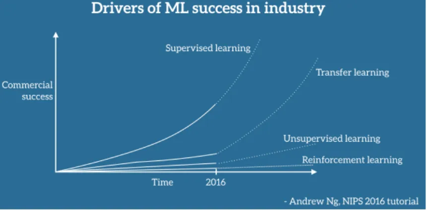
CNNs for their excellence in performance for image recognition and classification have been widely used for a large number of datasets but suffers from the problem of over-fitting if it is used on the small datasets. Also, it requires high computational power and large memory. It is merely possible for every researcher to find millions of datasets and train it with the advance resources integrated with GPUs and a large number of parameters demanding a long time. In such context, learnings from the pre-trained network on large datasets are considered very useful and are termed as transfer learn-ing. Unlike the traditional machine learning concept of having training and test data from the same feature space and the data distribution (Pan and Yang, 2010), transfer learning accepts the variations and, learnings are shared among different environment for improving the generalization (Goodfellow et al., 2016), accuracy and performance. Transfer learning is based on the concept of applying previously learned knowledge to the different task of similar nature by using the original pre-trained network to update weights on the new training dataset and to extract the features (Ali and Angelov, 2018). It is a time-saving, computationally cost-effective computer vision approach that uses already existed pre-trained models trained with larger benchmark dataset to solve the similar types of problems but on different dataset and scenarios. Applications of transfer learning have been increasing in recent years. Figure 2.1 shows its growing use to elevate machine learning commercially. Razavian et al., 2014 suggested the use of CNN extracted features as the primary input for visual recognition tasks based on the outperforming accuracy he achieved from overfeat extracted features classified by using linear SVM. Kim, 2014 achieved higher accuracy with state-of-the-art improve-ment on sentence classification using pretrained vectors by extracting the features and fine-tuning few hyperparameters. Shin et al., 2016 discussed the usefulness of transfer learning and achievement of state of art performance on mediastinal LN detection by using the ImageNet pre-trained models. Ali and Angelov, 2018 used the pre-trained CNNs based on the AlexNet Structure to extract the features and then SVM to classify the human faces for anomalous behavior detection.Pan and Yang, 2010 entails theo-retical insights on transfer learning, its strategies and applications on the issues like classification and clustering through a survey. Many organizations and researchers are putting efforts on collecting and providing different datasets of images freely as an initiative to encourage academicians, researchers, and data science communities for promoting research on automated tasks that involve the machine and deep learning to accelerate the ongoing developments in artificial intelligence. ImageNet, CIFAR, MNIST, COCO, PASCAL VOC 2012 are among the popular datasets that are trained with a large number of parameters identified through intense research on more than thousands of different object classes with different network models like VGG16, Xcep-tion, ResNet. Even many competitions are happening for object classifications, local-ization and detection on these datasets every year resulting in the new or modification
C H A P T E R 2 . L I T E R AT U R E R E V I E W
Figure 2.1: Drivers of Machine Learning success in industry2
of existing CNN networks with higher accuracy. The results from such competitions like ILSVRC are also available free for further research and improvements. Many re-searchers are using these network architecture, datasets, and pre-trained models for their research. ImageNet3 is one of the most popular image database portals main-tained by Stanford Vision Lab, Stanford University and Princeton University. It offers free use of 14,197,122 images with human annotation available at the moment and arranged according to WordNet hierarchy with the aim of providing well managed easily searchable images to the researchers around the globe. The ImageNet Large Scale Visual Recognition Challenge4(ILSVRC) is the object detection and image clas-sification competition happening every year since 2010 using the 1.2 million images with 1000 categories of objects from ImageNet as the training data. Most of the CNN network architecture mentioned previously with state of art performance are winners of this challenge. Besides, corresponding models from these network architectures trained on this ImageNet dataset and that achieved the highest possible accuracy dur-ing the time of challenge have been made available for free use. These weights and thus obtained trained models known as pre-trained models have been offered by dif-ferent deep learning frameworks like tensorflow, keras, caffe, pytorch as the imagenet weights and, are serving as the key basis of growing applications of transfer learning these days (Kornblith et al., 2018). ImageNet dataset has received global acceptance by the deep learning-related research community for image recognition tasks.
2.2
Theoretical Frameworks and Terminologies
This section briefly mentions the theoritical concept and definition of terminologies used in the training process of a CNN model.
1. Artificial Intelligence, Machine Learning, and Deep Learning
Artificial Intelligenceis considered as the human brain influenced intelligence
3http://www.image-net.org/
learning mechanism that uses a computerized system based upon statistical and computational techniques for extracting and learning the characteristics of an object or system such that it can utilize these learnings or representations for solving similar cognitive problems intelligibly like humans. John McCarthy, one of the pioneers of AI has defined it asthe science and engineering of making intelli-gent machines that have ability to achieve goals like human do. The recent research
and inventions on automation like self-driving cars, internet search engines, and speech recognition are rooted on the concept of AI.
Machine Learning is considered as the subset of Artificial Intelligence that is powering AI system through data analysis by developing statistical models and algorithm capable of analyzing data, identifying the existing patterns and mak-ing decisions without repeatable human interventions and programs. With the every day generated and increased big data in health, finances, marketing, satel-lite images or/in cloud platforms, hand-crafted data manipulation has been challenging; machine learning has evolved with high computational abilities to support these challenges with automation by using various methods like super-vised, unsupersuper-vised, active and reinforcement learning to learn the data and make predictions.
Deep Learningis considered as the subset of Machine Learning that has the ca-pability of learning data with more complexity by going more deeper as its name suggests and is highly influenced by the animal nervous system. It consists of multiple layers, usually referred as neural networks that are trained on datasets to learn their features so that they can result in the output with higher accuracy; training more data is considered as the main factor for increasing accuracy of predictions.
2. Artificial Neural Networks, Convolution Neural Networks, and their func-tioning
Artificial Neural Networks(ANN) are biological nervous system inspired neural frameworks consisting of a large number of units called neurons interconnected to each other for processing given inputs, learning their properties and making decisions or predictions based on the learnings during the processing stage. A simple ANN consists of an input layer, hidden layer, and output layer. Every layer consists of neurons and all these neurons are fully connected to each of the corresponding layers.
Convolutional Neural networksare hierarchical neural network system that consists of neurons resembling human visual cortex to make connections be-tween multiple layers, usually referred as convolutional and sampling layers existing in the network. Basically, these are feed forward deep learning neural network algorithm trained through back-propagation techniques and comprise three main layers: input layer consisting of input data with defined size; it is
C H A P T E R 2 . L I T E R AT U R E R E V I E W
followed by hidden layers consisting of many convolutional layers, activation functions, pooling layers, fully connected layers, and final output layer (fully connected) displaying the product of input layers processed and trained with neural networks. CNNs are characterized by following features:
• There is spatial local connectivity between neurons of adjacent layers. • They share weights among the architecture.
• They are shift/space invariant artificial neural network.
Convolutional layer: It is the core building block of a CNN that consists of filters (often called kernels) performing convolution operation across the height and width of the input feature in the initial network layers; mathematically, matrix multiplication is carried out between the no. of filters and the input feature size resulting in 2-dimensional feature map (or activation map). The number of convolutional layers can vary from one to many based on the number of datasets, feature complexities and computational capacity available. Present as hidden layers, they are mainly responsible for extracting features such as edges, colors, orientation of the input data and reducing the image size to ease the learning process with no loss in data properties. The size of a filter sliding over the input data is called stride. Pooling Layer: This layer is introduced to reduce spatial dimensionality of the output from convolutional layer thereby favoring less com-putational requirements and extracting highly dominant features of the input data. This layer also helps to reduce overfitting. Based on the way of analysis, there are two types of pooling layers: Average pooling: It averages the values of pixels contained in images covered by each of the filters. It reduces noises through dimensionality reduction. Max pooling: It results in the maximum value of pixels contained in the images and covered by the filters. It suppresses noise activation through positional invariance and dimensionality reduction. It is considered a better option than the average pooling.
Output layer: This layer is the fully Connected Layer introduced at the end of a CNN to learn non-linearity in features after the input images are learned from convolutional layers. This layer as the name suggested is fully connected to every neuron or activation maps in the previous layer. Flattening the images extracted as 3-dimensional data into vector takes place before the output layer generates the prediction. Based on the number of iterations applied, this flattening layer undergoes feed forward and back propagation process to reduce the errors and make predictions with high accuracy. This layer is also called the classification or prediction layer. Convolution and pooling layers together serve as the feature extractors, and the last fully connected layer functions as a classifier in a CNN. 3. Activation and Loss Functions:
Activation functions are introduced in convolutional layers to produce non-linear outputs without affecting receptive fields of the convolution layer. These are also considered as the decision function of the neuron´s output. There are different types of activation functions like ReLU, eLU, hyperbolic tangent, sig-moid function; the most widely used is the ReLU for its performance efficiency. Loss functionis introduced in the final fully connected layer to determine the discrepancy between the training and predicted output with true labels. Differ-ent functions like Softmax, Sigmoid, Euclidean are used as loss function depend-ing on the input-output nature feature dataset.
4. Parameters and Hyperparameters:
Parametersthough often used interchangeably with hyperparameters, are specif-ically considered as the variables that model updates during the backpropaga-tion phase; weights and biases are the core parameters of a deep neural network. Early in the training, bias is large, and variance is very small, whereas bias is small, and variance is high later in the training. If training is too long, the net-work will also have learned the noise specific to that dataset and is referred as overtraining. The minimum total error occurs when the sum of the bias and variance are minimal. Parameters are learned by the model during the training time.
Hyperparametersare the variable’s settings that technically control the behav-ior of a network model by determining its structure and the way that a model is learned. Hyperparameters are set before the training and are trained on valida-tion dataset before the optimizavalida-tion techniques; so, these are not learned from the training dataset; Below are the examples of some influential hyperparame-ters:
• Learning rate: It determines the way a model is trained; it quantifies the learning progress of a model that can be used to optimize its capacity. It specifically learns how quickly the gradient updates follow the gradient direction.
• No. of hidden units: Hidden unit is the layer between the input and output layer that determines the structure of a network model. It is important to regulate the representation capacity of a model. Normally, more the number of the layers, higher accuracy is obtained but it can suffer from overfitting by even learning noises of the layers if no proper regularization techniques are applied. Whereas, underfitting can happen with a smaller number of hidden units.
• Number of epochs: It is the number of times the whole training data is shown to the network while training.
C H A P T E R 2 . L I T E R AT U R E R E V I E W
• Batch size: It is the number of patterns shown to the network before the weights are updated; it optimizes the training of a network by defining how many patterns to read at a time and keep in memory.
Hyperparameters optimization: Optimization is a way of achieving best perfor-mance on training data by making an adjustment in the model. Hyperparameters selection is the fundamental task to achieve high performance of a model. There is no hard and fast rule for its exact determination, but various manual selec-tion methods and automatic deep learning algorithms like Grid Search, Random Search, and Bayesian optimization, ease the process of certain hyperparameters definition based on different criteria like cost function, memory requirement, nature of the training data and possible reduction in the test errors.
5. Regularization It is a process of avoiding overfitting in a deep CNN by introduc-ing additional parameters. Popular regularization techniques include Dropout, DropConnect and Weight Decay and common method of using them for reduc-ing overfittreduc-ing includes reducreduc-ing the network´s size by reducreduc-ing the number of learnable parameters thereby decreasing its memorizing capacity. Another tech-nique is adding weight regularization by making the network´s weights small and regularly distributed through the addition of cost to the loss function; it includes weight decay with L1 and L2.
• L1 regularization includes the addition of cost proportional to the absolute value of the weight coefficient, whereas L2 regularization includes the addi-tion of cost proporaddi-tional to the square of the weight coefficients value. L2 regularization is also called weight decay.
• Dropout: It is a regularization technique to increase the generalizing power of a network model by avoiding overfitting and results in the increment of validation accuracy. It is more suitable on larger networks with higher chances of learning independent representations. As its name suggests, it drops out the number of output features from the layer during training. 6. Other useful terminologies:
Batch Normalizationis the layer added to normalize activations of the input features before passing it to the next layer such that it helps in reducing the num-ber of epochs for training network, prevents overfitting and stabilizes training process.
Overfitting: It is the condition of learning to memorize the features on training data perfectly such that it performs properly on training data but executes bad performances on test data.
Classification is defined as a supervised learning process having predefined classes of data fed as an input training data to result in the same classes as out-put on the untrained test data.
Learning Process: Training data is fed into the network through input neural network layers, passes through different hidden layers and output comes from the final fully connected layers in the same ways as the input supervised data; the result is compared among the trained and predicted data with discrepancy between them referred as errors. The network tries to reduce this error by chang-ing weights of neurons in every iteration through back propagation mechanism and this process is called stochastic gradient descent (SGD). The parameter that determines the changes in weights is Learning rate. Training is the process of learning features of data through decision function.
7. Transfer Learning It involves the transfer of previously used models from which the new model can initiate a learning process on the new dataset based on the already learned features or patterns achieved from another dataset for other issues. Mathematically, Pan and Yang, 2010 has defined it as :
Given a source domain DS and learning task TS, a target domain DT and learning task TT, transfer learning aims to help improve the learning of the target predictive function fT(·) in DT using the knowledge in DS and TS, where DS , DT or TS , TT.
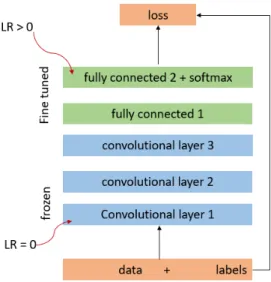
The transfer in this process can involve either the instant transfer of weights, or the transfer of feature properties, or the parameters used in extracting or training a model or the transfer of relational knowledge among two different data sources (Pan and Yang, 2010). In deep learning, transfer learning can be applied through feature extraction or fine tuning techniques as described below:
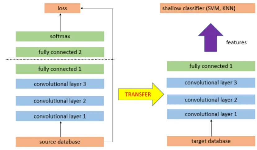
a) Pretrained model as a feature extractor
This strategy involves the use of pretrained model by removing the last fully-connected layer of the source data to extract features of the new data. Then, a classifier, either as a new fully connected CNN or machine learning classifier like linear Support Vector Machine or kNN can be added and trained on the extracted feature data as shown in Figure 2.2.