UAV Downwash-based Terrain Classification using
Wiener-Khinchin and EMD Filters
J. P. Matos-Carvalho1, André Mora1, R. T. Rato1, Ricardo Mendonça1, José M. Fonseca1
1 Computational Intelligence Group of CTS/UNINOVA, FCT,
University NOVA of Lisbon, Portugal {jp.carvalho, atm, rtr, rmm, jmf}@uninova.pt
Abstract. Knowing how to identify terrain types is especially important in the autonomous navigation, mapping, decision making and detect landings areas. A recent area is in cooperation and improvement of autonomous behavior between robots. For example, an unmanned aerial vehicle (UAV) is used to identify a possible landing area or used in cooperation with other robots to navigate in unknown terrains. This paper presents a computer vision algorithm capable of identifying the terrain type where the UAV is flying, using its rotors’ downwash effect. The algorithm is a fusion between the frequency Wiener-Khinchin adapted and spatial Empirical Mode Decomposition (EMD) domains. In order to increase certainty in terrain identification, machine learning is also used. The system is validated using videos acquired onboard of a UAV with an RGB camera. Keywords: Image Processing, Wiener-Khinchin, EMD, IMF, Machine Learning, Terrain Classification, UAV.
1 Introduction
Nowadays, Unmanned Aerial Vehicles (UAVs) have a huge impact in the area of research and industry. In the research area since it is a recent topic and therefore little studied. In the area of industry, being a lightweight and low-power robot, it can be used in various situations, such as precision agriculture, emergency landings and rescue missions.
In this case, the task of the UAV is to cooperate with the Unmanned Surface Vehicle (USV) so that it reaches its intended destination. This is the purpose of this paper. With an RGB camera mounted on the UAV it is possible to receive the images from the outside from the effect of the downwash caused by the UAV. This effect is only felt at low altitudes and has unique effects on the terrain (e.g. the circular wave effect on the water terrain).
Two different techniques were merged to classify the terrain type: Wiener-Khinchin Theorem and Empirical Mode Decomposition (EMD). These techniques, although well
developed for 1-D signals, are seldom applied in image processing domain. Thus, many of the following questions are still unknown: How to apply both algorithms for image processing? Is it necessary to evaluate the whole image or may it be necessary to find methods to reduce computational complexity? Knowing that the EMD technique decomposes the signal into several intrinsic mode functions (IMFs), which of the IMFs best classifies the type of terrain? How can the Wiener-Khinchin theorem and the EMD algorithm complement each other? These challenges are addressed throughout this work and how they have been resolved to have the best results possible.
2 Contribution to Industrial and Service Systems
The behavior of different terrains when exposed to wind turbulence (downwash effect) is discernable and, by processing that behavior using Wiener-Khinchin (W-K) and EMD filters, we can generate singular results to identify a terrain type. Exploiting this knowledge, a novel terrain classifier is proposed and presented as a scalable service that can be used simultaneously by several applications and systems. Therefore, the herein presented work is focused on the Industrial and Service Systems domain, specifically, in Robotics and Integrated Manufacturing and Signal Processing topic.
3 Related Work
UAV applications is a topic that lately has arisen a lot and is becoming more important in several areas and is predicted that it will soon have a great impact on society [1]. One of the areas that is causing a great impact is in the area computer vision with the aim of making an UAV in an autonomous robot. For this, and concretely in this paper, the UAV must be able to capture, process and analyze the images of the environment in order to classify the type of terrain where it is flying over. Many researchers have proposed several methods in the classification of terrain, such as texture algorithms [2], [3], [4], [5], color information [6] and other types of sensors that help in the classification decision, such as LIDAR type sensors [7], [8], [9]. Currently, on terrain classification using the downwash effect concept there are two recent works [10], [11]. The first one, used the concept of optical flow to detect the dynamic features of an image (Lucas Kanade algorithm [10]), from an RGB camera that was placed in an UAV. The objective of this work was to decide whether the terrain under study was water or not water. However, it takes at best 4 seconds to classify whether the terrain is water-type or not. Thus, it forces the UAV to hover in a steady position to classify the terrain. Another work that exploits the downwash effect to classify the type of terrain, takes advantage, not only of the dynamic part but also the static part of the image. In relation to [10], this work in addition to classifying water-type terrains can also differentiate vegetation and sand terrains in real time (less than 0.03 second). To classify the terrain type, the algorithm uses the Gabor concept [11] to remove the static texture of the terrain, complementing with the concept of optical flow (Farneback algorithm [11]) to remove the dynamic part of the terrain under study.
Color information was also used in [6] to classify four types of terrain. Converting each pixel of the image by the square root of the three channels of the pixel itself, the result will emphasize the color that most represents the type of terrain (e.g., blue for water). Other methods that rely on laser scanners also proved to differentiate between water and non-water terrain with good accuracy [7], [8], [9]. However, shallow water terrain will increase the decision error due to laser reflection and thus the sensor classifies as non-water-type terrain.
4 Proposed Model
Two algorithms were used in the proposed classifier: Wiener-Kinchin (W-K) and Empirical Mode Decomposition (EMD). Since these two techniques are independent of each other (one works in the spatial domain and the other in the frequency domain), it is possible to operate in parallel mode to increase the processing speed. From the proposed classifier model, as depicted in Figure 1, it is possible to identify six fundamental stages:
1. Rectified Image: For the proposed classifier to be generic enough to work for all RGB cameras (depending on the resolution), it is first necessary to calibrate the image and mitigate its distortion;
2. Dimensionality reduction: To increase the classification speed only a small piece (i.e., region delimited by the red square) of information was extracted in the image (in this case the information was taken in a square format); 3. Empirical Mode Decomposition (EMD) filter: In the spatial domain, the EMD
algorithm is applied in the image;
4. Computation of the first Three IMFs: Having the EMD obtained previously, the first three Intrinsic Mode Functions (IMFs) are taken to analyze the signal coming from the terrain under study;
5. Wiener-Khinchin (W-K) filter: Vertical and horizontal projections are applied to the thresholded image, extracting unique features that help differentiate the different types of terrains;
6. Terrain Classification: Certain decisions can be improved by using machine learning [12], [13], [14]. It will contribute to a more automated and reproducible process and possibly to increase the decision accuracy.
Fig. 1. Proposed terrain classifier model.
Five different terrain types representing the most common natural landscapes were selected to be the output of the proposed classifier: lake, pool, vegetation, dirt and sand terrains. When exposed to wind turbulence (downwash effect) distinct behaviors emerge according to the type of terrain. For instance, in water-like terrains, a circular wave movement outwards a center point is observed. In the vegetation, the movement occurs linearly from the inside to the outside. In sand and dirt, the movement is almost static.
5 Experimental Results
5.1 Empirical Mode DecompositionAccording to Huang [15], [16], the principle of EMD is to decompose the signal into several frequencies, called Intrinsic Mode Functions (IMFs) and each IMF represents a zero-mean AM-FM function [17]. EMD is performed as follows:
1. Initialize vector h(t) and k(t) for a given image I;
2. Get local maxima and minima from h(t) to build an upper s+(t) and a lower s(t) envelopes;
3. Calculate the mean envelope:
meanenvelope = 0.5 x [s +(t) + s -(t)] (1)
c(t) = c(t) - meanenvelope (2)
5. c(t) is verified against a defined threshold. If it is above it, then h(t) = c(t) and repeat step 2-4. If it is below, then an IMF is found and h(t)= k(t) - c(t); k(t)= c(t); and repeat the steps 2-4 to find the next IMF.
Only the first three IMFs and the baseline are taken. Next, two heuristics are computed to identify the terrain: the number of local maximums given by an IMF and the number of times the IMF has crossed zero along the vector. These two heuristics were calculated for a set of 332 frames. From Fig. 2 it is possible to identify 5 clusters representing a terrain type. Despite the positive results, there are a few outliers. To improve accuracy, EMD was complemented with the Wiener-Khinchin filter.
a) b)
c)
Fig. 2. Intrinsic Mode Function – The zero crossings in relation to the total number of local maxima. a) IMF-A; b) IMF-B; c) IMF-C.
5.2 Wiener-Khinchin Filter
The Wiener-Khinchin filter (W-K) is performed in the frequency domain while the algorithm in section 5.1 is presented in the spatial domain. To increase computational
speed, the algorithm is not used in the total image but only in sub-region of it. To compare different types of terrain, it is necessary to compute the average value from that sub-region and normalize it apply general thresholds. As the Wiener-Khinchin theorem uses the concept of energy in the frequency domain, it becomes intuitive to normalize according to energy. These same values were then passed to the frequency domain. Next, frequency values are signal crossed with themselves. Finally, an inverse transform is performed. In last, it is possible to use the same heuristic characteristics that were used in section 5.1. This algorithm was also applied to the same set of 332 frames (90 frames are pool water, 35 frames are lake, 74 frames are vegetation, 55 frames are sand and 78 frames are dirt). As depicted in Fig. 3, with the Wiener filter it is also possible to clearly identify the five terrain types. However, lakes present greater uncertainty. Due to this situation, to increase the probability of a correct classification, machine learning was also added to the proposed model.
5.3 Classification
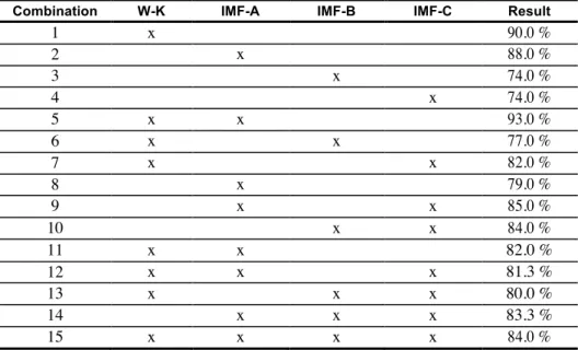
To automate the classification process, feed-forward neural network (NN) was used. Several tests were done to assess the best combination between the Wiener-Khinchin filter and Empirical Mode Decomposition. The first step was to create a neural network composed of two layers: the first layer is hidden and contains 10 neurons; the second layer contains 5 neurons that represents the terrain types.
Fig. 3. Wiener-Kinchin Filter – Number of times the signal crosses the zero in relation to the total number of local maxima.
A sigmoidal function was used as activation function and the final classification of the terrain under study is validated by the neuron that gives a greater result (the training dataset was composed by 334 samples, from which 70% were for training, 15% for testing and 15% for validation). Table 1 was produced showing the classification
accuracy in all possible combinations. The best was the Wiener-Khinchin filter with the first IMF, yielding a 93% terrain classification accuracy.
6 Conclusions
The goal of this work was to design a terrain classifier using two algorithms that exploit the UAV’s downwash effect. The two algorithms are the Wiener-Khinchin filter and Empirical Mode Decomposition. It was proved throughout this work that both algorithms worked well together by presenting good results in the terrain classification. Regarding the EMD algorithm, it was emphasized that, despite the high accuracy in the NN decision, the probability of correctly classifying a terrain worsens from IMF to IMF and therefore it is always better to use the first IMF. However, it is always possible to improve certainty in the decision and therefore the EMD algorithm was complemented with the theory of Wiener-Khinchin. With this addition, the certainty in the classification of terrains managed to extend to 93%.
Table 1. Combination of the two algorithms developed for the proposed classifier.
Combination W-K IMF-A IMF-B IMF-C Result
1 x 90.0 % 2 x 88.0 % 3 x 74.0 % 4 x 74.0 % 5 x x 93.0 % 6 x x 77.0 % 7 x x 82.0 % 8 x 79.0 % 9 x x 85.0 % 10 x x 84.0 % 11 x x 82.0 % 12 x x x 81.3 % 13 x x x 80.0 % 14 x x x 83.3 % 15 x x x x 84.0 % Acknowledgments
This work was partially funded by FCT Strategic Program UID/EEA/00066/203 of the Center of Technologies and System (CTS) of UNINOVA - Institute for the Development of new Technologies.
References
1. Bestaoui Sebbane, Y. (2018). Intelligent Autonomy of UAVs: Advanced Missions and Future Use. CRC Press.
2. Linderhed, A. (2009). Image Empirical Mode Decomposition: A New Tool For Image Processing. Advances in Adaptive Data Analysis, 01(02), 265-294.
3. Feng, Q., Liu, J., & Gong, J. (2015). UAV Remote sensing for urban vegetation mapping using random forest and texture analysis. Remote Sensing, 7(1), 1074-1094.
4. Khan, Y. N., Komma, P., Bohlmann, K., & Zell, A. (2011). Grid-based visual terrain classification for outdoor robots using local features. IEEE SSCI 2011: CIVTS 2011.
5. Pietikäinen, M., Abdenour Hadid, Guoying Zhao, and T. Ahonen. 2011. Computer Vision Using Local Binary Patterns. Vol. 40. Computational Imaging and Vision. London: Springer. 6. Ebadi, F., & Norouzi, M. (2017). Road Terrain detection and Classification algorithm based on the Color Feature extraction. Artificial Intelligence and Robotics (pp. 139-146). IEEE, 2017. 7. Yan, W. Y., Shaker, A., & El-Ashmawy, N. (2015). Urban land cover classification using airborne LiDAR data: A review. Remote Sensing of Environment, 158, 295-310.
8. Wallace, L., Lucieer, A., Malenovsky, Z., Turner, D., & Vop¥nka, P. (2016). Assessment of forest structure using two UAV techniques: A comparison of airborne laser scanning and structure from motion (SfM) point clouds.
9. GruszczynSki, Wojciech, Matwij, Wojciech, Cwiakaªa, P. (2017). Comparison of low-altitude UAV photogrammetry with terrestrial laser scanning as data-source methods for terrain covered in low vegetation. ISPRS Photogrammetry and Remote Sensing, 126, 168-179.
10. Pombeiro, R., Mendonca, R., Rodrigues, P., Marques, F., Lourenco, A., Pinto, E., Barata, J. Water detection from downwash-induced optical flow for a multirotor UAV. OCEANS 2015 (pp. 1-6). IEEE.
11. J. P. Matos-Carvalho, J. M. Fonseca, and A. D. Mora. UAV downwash dynamic texture features for terrain classification on autonomous navigation. Proceedings of the 2018 Federated Conference on Computer Science and Information Systems. Vol. 15. Annals of Computer Science and Information Systems. IEEE, 2018, pp. 1079-1083.
12. Mora, A.; Santos, T.M.A; .ukasik, S.; Silva, J.M.N.; Falcão, A.J.; Fonseca, J.M.; Ribeiro, R.A. (2017) Land Cover Classification from Multispectral Data Using Computational
Intelligence Tools: A Comparative Study. Information 2017, 8, 147.
13. Heung, Brandon, Hung Chak Ho, Jin Zhang, Anders Knudby, Chuck E. Bulmer,and Margaret G. Schmidt. 2016. An Overview and Comparison of Machine-Learning Techniques for Classification Purposes in Digital Soil Mapping. Geoderma 265 (March): 62-77.
14. Giusti, Alessandro, J. Guzzi, Dan C. Ciresan, Fang-Lin He, Juan P. Rodriguez, F. Fontana, M. Faessler, et al. 2016. A Machine Learning Approach to Visual Perception of Forest Trails for Mobile Robots. IEEE Robotics and Automation Letters 1 (2): 661-67.
15. N. E Huang and al., The empirical mode decomposition and the Hilbert spectrum for nonlinear and non-stationary time series analysis, Proceedings of the Royal Society Lond. A, 454, 903-995, 1998.
16. P.J. Oonincx; Empirical mode decomposition: a new tool for S-wave detection, CWI Reports of Probability, Networks and Algorithms (PNA) 2002, PNA-R0203, ISSN 1386-371 1
17. Rato, R. T., Ortigueira, M. D., & Batista, A. G. (2008). On the HHT, its problems, and some solutions. Mechanical Systems and Signal Processing, 22(6), 1374-1394.