Ciencia.'( daTerra(UNL)
. y ' Lisboa>C•• N." 14 ,
··pp. 243-256
5 Figs.Tertiary evolution of th e Sao Vicente and Setubal submarine
canyons, Southwest Portugal: insights from seismic stratigraphy
Tiago M. Alves(l ), Rob L. Gawthcrpe' '), David Hunt'!'
&
Jose H. Monteiro(2)
I • Basin StudiesandStrat igraphic Group, Department of Earth Sciences, The University of Manchester, M 13 9PL, Manchester, United Kingdom; tel, (44) (16 1) 2753696, fax (44) ( 161) 2753947; talves@ fsl .gc.man.ac.llk
2 _ Departa mento de Geo logia Marinha, Instituto Geclcgico e Minci ro (iGM), Estrada da Portela, Alfrag idc, Apartado 7586, 2720 Alfragidc, Ponuga l.
RESUM O
Palav ras-c have: Margem Su doesre Iberica; Neogenico; canboes submannos; turb iduos; leques submari nes .
Os canhoes sub mari nes de S etubal e de Sao Vicente localizam-se na margem Sud oesre Iberica. ao largo de Portugal. Embora reconheci dos como estruturas de idade phocenica a qua ternaria,0seu desenvolvimento durante0Ce noz6ico nan foi , ate a data, inteiramente compree ndido. Foi usada uma malha de linhas slsmicas 20 para car acterizar os depositos sedimen tares dos flancos adjacentes aos can hoes submari ne s. Foi investigada a relar,:iio entre a estrutura geologica da margem e a locahzacac actual dos canhacs. A intcrprctaeao des principais unida des slsmices permitiu 0 reconhcci mento de tres geraczes de ravinamen tos ap6s0
pro vavel Ohgocenic o medio. Foram identificadas sets unidades agrupadas em duas sequencias sis micas e correlacionades com dados estratigraficos da margem ocidental lben ca.ASeq uenc ia Sismica 2 (SS2), mais antiga, sobrepze-se a un idades deformad as doMesozoico e Bocenico superior. A Sequenc ia Sismica I (SS 1) e composta po r quarro difere ntes unidades separa das de SS2 por uma superficie erosive, A base dos corpos sedi rnentares estudados e marcada por uma exrensa super ficie eros iva, provavelmente resu trante de uma descid a rela uv a do mve teustatlco durante 0 Oljgocenico mferior/medio. Apos esre even to, a dep osicao foi reiniciada no Oligo cenico term inal sob a forma de dcp6sitostransgress ivos ede preen chimen tode canai s. Urn novo hiato deposicional e registado dura nte0Burdi galiano na Bacia do Ba ixo Tejo, comcidcntc com a discon rinu idade que sep ara SS Te SS2. Esta pode ser correlacionada com a d iscordancia da Ami bida e consequente fase paroxismal Burdigal iana do dominio Bence . Pre sent emente , os canhces submari nos de Sembe r e de Sao Vicente ravi nam localmente SS I e SS2, form ando canais distintos des ev idencia dos pelo s dad ossisrnicos. Na parte supe rior da plata forma continen tal ambos dissccta m zonas muito deformadas sujeitas a importan tes processos erosivos.
ABSTRACT
Key words: Southwest Iberian margin; Neogene; submarine canyons; turbidites; submarine fans.
The Serubal and Si o Vice nte can yons are two major modem submari ne canyons loca ted in the so uthwes t Ibe rian margin off Portugal. Although recognised as Pliocen e to Quaternary features, the ir develop ment duri ng the Tertiary has not been fully und er-stood up to date. A grid of 2D seismi c data has been used to chara cterise the sedimentary deposits of the adjacent flanks to thc submari ne canyons. The relationship between the geological struc ture of the margin and the canyon's presen t locat ion has been investigated. The interp retation of the main seismic un its allowed the recognition of three gen erations of ravin ements prob ably ori ginated after midd le O ligocene. Six uni ts gro uped in two d istinctive seismic sequences have been identified and correlated with o ffshore stratigraphic data . Se ismic Seq uence 2 (SS2), the oldest, overlies Meso zoic and upper Eoc ene deformed uni ts. Seismic Sequence I (SSI) is composed of four different seismic packages se para ted from SS2 by an erosional surface. The base of the stud ied sed iment ridges is marked by an extensive erosional surface derived from a early/middle Ol igocene relat ive sea-level fall. Deposition in the adjace nt area to the actual canyo ns was rcinitiated in late Oli gocene in the form of'transgre ss ive and channel-fill deposits. A new depositional hiatu s is recorded onshore during the Burdigalian , coincident wit h the unconfonnity separa ting SST and SS2. Th is can be correlated with the Arni.bida unconformity and with the paroxys mal Burdigalian phase of the Betic dom ain. Prese ntly, the SerebelandSio Vice hte submarine canyo ns locally cut SS I and SS2, fonning distinctive channeTs from those reco gnised on the seismic data.. On the upper shelf bcth dissect highly deformed areas subject to important erosion .
1° Congresso sobre0Cenozoicc de Portugal
I NTROD UCTION
The Scnibal and Sao Vicente submarine canyons are the two most pro minent geomorpho logical features in the sout hw es t I berian ma rgin (fi g. I ) .They form two independent c hannels deeply dissecting the la tter in its north ern and southern bou nd aries. T he location of the submari ne can yons has been related
with
major tectonic featur es (Boill otet aI.,
1974). In fact, they both follow the tre nd oflate-Hercynian faults recogni sed onshore. The uppe r sector oftheSetubal
canyon is be lieved to cons titute the conti nuation of the Grindola fault (fig. 1). The Sao Vicente canyon is aligned with the Od emi ra-Avila fault, foll owi ng its trend through the full length of the canyon 's co urse (fig. I ).Previous studies have focused directly or ind irectly the Portuguese submarine ca nyons, occasionally us ing seismic data with relativ ely shallow dep th of pen etratio n (Andrade , 1937; Boillotet al.,1974 ; Vanney& Mougenot, 1981 ; M ougen ot, 1988; M auffret
et aI.,
1989). In these, the Tertiary evolution of the two cany on sys tems has not been
fully
understood. T his paper aims to characterise the seismic facies of the Tertiary sediment ridge s adj acent to the Senibal and Sao Vicente canyons, p roposing a lit ho s tr a tigra p hi c frame work for the interpreted sec tions (figs. 1 and 2). T he studied ridges constitute indepe ndent deposit ional a reas , separated from the upper shelf by NNW-SSE and NNE-SSW fault systems (fig. 6). Seismic facies anal ysis is used to recognise the dep os itiona l e nvironme nts asso cia ted with t he units . Finall y, the ir evolu tion is discussed taking into account t he onshore stratigraphy an d the de velopmen t of the southwest Iberian margin during the Tertiary. A revi sed interpretation of the canyons' evolution duri ng the Tertiary is, there fore, proposed on this paper.DATA AND I NTERPRETATION M ETHODS
The data presented in thi s paper was collected in a non-exclu sive surve y ca rried out by G SI (G eophysical Serv ice Incorporated)inNovember and De cemb er 1984,' on- boa rd of t he MN PE Hagge rty. The GS l survey pennittcd the acq uis ition of data well beyond the acoustic ba sement of previous works. T he seismic system used an airgu n a rray operating at 200 0 PSI as ene rgy source. Th e data acq uis ition was guaranteed by a 3000-metcr cab le with 120 geop hone groups and 27 geo phones pe r group. The average estimated depth of the cable was II metres. " The navigation was ba sed on two independent systems: S YLE DrS (p rimary system) and GEONAV (secondary system). Seismic reflec tion lines ofthe SINFAR 76 cruise, collected and suppli ed by IGM [ Institute Ge olog ico e M ineiro), have also been interp rcted (fig. 1).
The main seismic units have be e n es ta blis hed by delimiting the stratal termination s, onlap and downle p surfaces, and relevant unconformities betwe en the internal reflectors ofadjacent pac kage s. The se d efine erosiona l or no n-de pos ition surfaces separating younge r strata from old er roc ks a nd represents a s ignific an t hiatus (sensu M itchu m, 1977) . Particular .care was usedinthe identifi-ca tion of the seismic packages underlying the
sedimen-244
tary rid ges . Re cognition oftheir relative ages allowed the definition of the evolutionary framework prop osed on this paper. Classification of the seis mic fac ies is based on the nome ncla ture of M itebum e t at. ( 1977) and Posa mentier
et al.
( 1991). Interpretation of the unit's age is based on p re vio us seis m ic data in te r pre ta tions (Coo p ie r &Mouge not, 1982), on dred ge data supplied by the IGM previous ly compiled in Mougenot ( 1988), and on the on -s hore -st rati gra phic fram ew or k-s of Cunha ( 1992) and Pimentel (1998). Th e depositional models considered by Weime r (l99 1), Sha nmugan & Moio la ( 1988), Mutti ( 1977) and Ricci-Lucchi ( 1975) have been applied on the deposit ional facies interpretations.
GEOLOGI CAL SETT ING
Th is study comprises the offshore region of southwest Iberia, between the co-o rdinates 38°30N - 37°0 0N, and 9°30W _ 8°45 W, in wh at is c urre ntly de nomina ted as Alentej o margin (fig. 1).The margin originated during the Mesozo ic as a consequence of the multi -phased rifting respon s ible for the separation and expansion of the No rth Atlantic Ocean (P inhe iro etal., 1996). The existence of Mesozo ic un its onshore in the Santiago do
Cacem
sub-basin (fig. I), in parall el with dredge and seismic dat a collected offshore (Mougenot et al., 1979), confirms the ext ension of the Mesozo ic rifting deposits towards the south, in what is named as Alentej o basin.Th e Alentejo margin is c harac terised by a narro w shelf and by a gentle co ntine ntal slope e xtending from
Arrabida
to the Descobridores Seamounts (fig.1). Ashallow zone, the Sines Spur, stre tching out from the Sines Cape to the Pr incipes de Avis Seamounts, separates the northern and southern sectors of the margin.Setubal
Canyo n dissects the northern sector approximately halfway its length , following an ENE to WSW tre nd in its upper part. In its inte rmediate zone becomes a very incised cas t-west ori ented c hanne l. After be ing inter sected by tbe Lisboa Canyon and mu ltiple submarine valleys, changes its course to a northeast-southwest orientati on (fig. 1). Th e submarine canyon finally termina tes its course on the Tagus Ab yssal P lain, offshore Lisbon .Th e southern sec tor of the Alent ejo margin is cha rac-terised by a furth er en largeme nt of the slope. H ere, the shelf is esse ntia lly composed of Paleozo ic rocks cons ti-tut ing the basement of the Mesozo ic Alentejo ba sin. Sao Vicente cany on, located roughly at 37°00N, constitut es a maj or mo rphologica l featur e separating Alentejo and Al-garve margi ns (fig. I). The canyon
totlowsa
sim ple NE-SW or ientation forming a wide submarine channel term i-natin g on the Horseshoe Abyssal Plain.The stud ied zones referred on this paper are located on the flanks of the two submari ne canyons, con stituting Tertiary sediment ridges excav ated by the present canyon-c hannels . Both rid ges form thicanyon-ck (up to 1.0 secanyon-conds in two-way travel time) acc umula tions separated from the thin(ave raging 300 milli seconds of two-way travel time thic kness) Tertiary sediments deposited on the she lf. Thi s boundary is marked by a fault system tre nd ingNNW ~ SS E
CienciasdaTerra(UNL), 14
· ··· · · · ·· ···· I- ~I
5 4· 3· 2' c'-C
s'
6',
.
-
--...1-- '
..
'.>"
.
1--1
.' '"...f--.---I
". ".
. '.
1-- '
.
f--.---I
"
..
2
3A • • • • _
3B
"
' I' -- - . __._ 1A ' "
" .
"+-~.
~~
...
r( ""
,
•
I
,
e
'0.-,'"'-... a.-. t all"a
I
I
" L-'" \
-..
'"
•
1,
' Y
ic
...
,
....
I
- '"
' ~:
v
'
~,\ '-
< .c ~ ,; J "."
C
'0.--1..
,,--J
~
"' P O
..
~..", "?
...
w~c;.-
.'
z"
),;:
~ , / ~ w0t ,
0Setuba l w
I
...C8f1Ytln ~
.
Zc)
5 . ", .S...Oln
Fig. I - Loca tion of the studied submarine canyo ns and refCIT edseismicgri d. SINFAR 76data in dott ed lines.The main offshore structures interpreted on seismic data are also shown . The bathymetry of the margin was obtained usingGISda ta supplied by the Instituto Geologico c Mineiro (10 M). Grey areas represent the location of the seis mic data shown on this paper. Key: CCwCascais Ca n-yon; DS-Descobridores Seamounts; HSAP-Horseshoe AbyssalPlain; AAP-Afonso deAlbuquerquePlateau; PAS-Prin cipe de Avis Seamounts; TAP.Tagus Abyssal Plain; RL-Rincao do Leb re Plateau ; SP-Sagres Plateau;
gf-Grindola Faull; oaf-Odemira-Avila Fault.
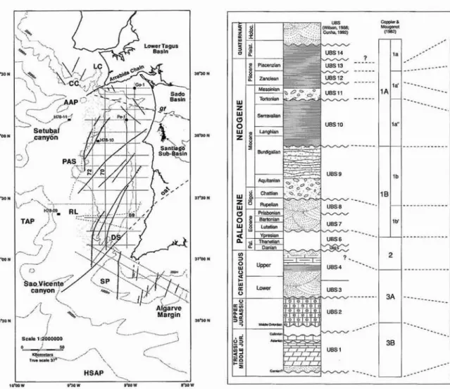
Fig. 2~ Sequence stratigraphyofwestem Iberia Tertiary (Cunha, 1992) and Mesozoic (Wilson, 1988) deposits correla table with packages identified on the seismic data. Th e seismic stratigraphy of the units interpreted in this paper is represented in the right-hand side co lumn. Signed units (-) havebeendred g ed and dated (Mougenot., 1988).
,
ST RUCTURAL SETTING
The Alentejo margin shows a different tectonic setting in comparison with the adjacent western and southern Portugu ese margin s. Well and o nshore data re veal a relative absence of a ductile salt layer below the Jurassic to Tertiary units in the Alentejo basin.
The Alentejo margin can be divided into two distinc-tive structural zones based on their main structural trends. In the northern Alentejo margin the main fault-trend is NNW·SSE to NW·SE oriented, in similarity with the main faults dissecting the SSW-NNE Arrabida Chain (Ribeiro et al., 1990). A major inflexion of the structural trends occurs halfway in the margin. From the Sines Spurtothe Sao Vicente Canyon, the NNE·SSW and NE-SW
struc-tural trends are domi na nt. On seis mic data there are evidences that these faults have contro lled the Mesozoic evolution of the Alentejo basin, forming fault-bounded horst and graben structures (figs. 3 and 4) . Evidences o f recent fault-reactivation are seen on the seismic data, although the relatively lo w seismic activity historically and instrumentall y pre se ntly record ed on the margin (Cabral, 1995).
Alpine deformation in the Alentejo margin has a different character when compared
with
central-western and Algarv e margins (fi g 1). On the shelf, folding o f Mesozoic to Eocene units and fault reactivation have been recognised on seismic data (figs. 3 and 4). On the deeper areas of the continenta l slope, subs idence has been recorded since late Oligocene, originating a thick Tertiary10Congresso sobre 0 Cenoz6icode Portugal
basin over the southwest Iberian margin (Mo ugenot, 1988) . Salt anticlines have not been identified on the seismic data. Folding of the Tertiary units is recorded by two broad E-W synclines ran ging the southe rn and northern sectors ofthe Alentejo Basin. These are separated by the Sines Spur and covered by relatively thin Neogene to Quaternary units over the shelf and upper slope areas (figs. 3, 4 and S]. Deformation on the margin is, therefore, ma in ly confined to the Princfpe s de Avi s and Descobridores Seamounts region (fig. I).
STRATIGRAP HY OF TH E ALENTEJO M ARGIN
Onshore data collected from the Santiago do Cacem sub-basin and offshore well data were interpreted using the same stratigraphic framework used for the Lusitanian and Algarve basins. Although with important basin al differences in relation to the structural and depositional evolutions, the three margins have been affected by the same rifting events during the Mesozoic.
Tertiary deposition was important in the Lower Tagus and Sado basins (figs. 1 and 2). The first was originated as a co mpress io nal foredeep basin with associated fault-bounded subsidence (Rasmussenet al.,1998). Sado Basin was originated in the middle Eocene during the Pyrenean phase of the Alpine orogeny, and resumed its development during the late Neogene (Betic phases) and Quaternary (P imentel, 199 8). Elsewhere, the Tertiary deposition is only represented by Pliocene to Quaternary shallow marine and paralic deposits, aligned in a band parallel to the actual shoreline. Offshore, Holocene deltaic systems are developed on the mouth ofthe Sado and Tejo estuaries (Mougenot, 1988). On the Alentejo shelf, the Tertiary units show a distinctive distribution north and south from the Principe s de Avis Seamounts (fig. 1). Cenozoic depo sition was mainly located north from the seamounts, where deform ed Eocene de posits underlay the Miocene to Quaternary units (Mougenot er
al.,1979; Mougenot, 1988). South ofthe same submarine features, on the outer shelf, thin Mioccne to Quaternary sedi men ts overlay deformed Mesozoi c units . These abruptly change into thick sedimentary units on the continental slope.
SEISM IC STRATIGRAPHYAND SE ISM IC FACIES CHARACTERISATIO N
The studied areas comprise the sedimentary ridges south and north of the actual Setubal and Sao Vicente canyons, respectively (fig. I). The ridges form part of the continental slope in de pths rangi ng the 800 to 1200 meters and are marked by presenting a similar seismic stratigraphy. Six seismic units have been identified and divided into two distinctive seismic sequences (SSI and SS2). Th ese are separated by a maj or unconformity rec og nised in both ca nyo ns (figs. 4 a nd 5 ) . T he unconformity, resembling the character of an erosional surface on the seismic data, has been correlated with the
246
Am\bida tectonic event that marks the paroxysmal phase of the Betic domain , oc curred during the Burd igalian (Antuneset al., 1999). The seismic stratigraphy of the studied areas is represented in figure 2. From the top to th e bottom, the interp reted sequences comprise the following units:
Seismic Sequ ence I (SS1)
The Seismic Sequence 1 includes Units I to 4. The uppermost Unit 1 shows a constant thickness ranging 150m s showing lo w amplitude to se mi-trans parent irregular internal reflectors. These are subparallel with onlap onto surface 2a (c.f Mougenot et al., 1979). The base of Unit 1 is marked by a high amplitude confonnable surface occasionally showing onlap. The unit is interpreted as comprising turbid ite or hemipelagic sediment sheets. Broad sectors with semi-tra nsparent, flat reflectors are characteristic of these facies, a feature observed on the seismic data and confirmed the facies interpretation of Weimer ( 1991) and Shanmogan & M oio la ( 1988 ). Packages presenting parallel semi-transparent reflections have also been interpreted as distal turbidite and pelagic deposits of non-channelled environments in the Agadir Canyon, Morocco (Ercilla et al.;1998). Dredge samples collected on the slope adjacent to the studied area (fig. 1) co nfirmed the pelagic c harac te r of th e sedi ments composing Unit I, allowing their dating .as Piaeenzian (Dredge H78·11 ; Mougenot, 1988). Thus, the unit can be corre lated with UBS 13 of Cunha (1992). The location of Unit I, out of the present mouth of the canyons, suggests that the unit does not comprise channel-deri ved material from Setubal and Sao Vicente structures. Instead, the internal character of the package resemble fine pelagic to hemipelagic deposits directly derived from the adjacent continental shelf and locally deposited as sediment waves (figs 4 and 5).
The base of Unit 2 is marked by an onlap surface with high amplitude. Unit thickness ranges from l OOms to 200ms. Internally, it is composed of wavy sub-paralle l reflectors with mediwn to low amplitude. These are inter-preted as hemipelagic deposits, in similarity with Unit L The wavy character of the unit may be associated with contourite deposits, abundant on the Algarve Margin as a result of the Mediterranean water flow (Mougenot, 1988; Lebrciroet al.,1997). High-reso lution seismic reflection data of the SINFAR76 cruise reveals the presence of broad sediment waves on Units I and 2. Extensive contourite sediment ridges have also been identified throughout the Algarv e Margi n in particular nea r the Gulf of Cadiz (Faugereset al.,1999). However, localised synsedimentary deformation is also visible on the seismic data, along with faulting and tilting of some of the interpreted packages. Some ofthesc deformation features seem to induce locally part of the wavy character of Unit 2 (fig. 5). Dredge sampling (Dredge H78-1l ; Mougenot, 1988) and seismic data previously collected on the shelf region (Copp ier& Mougenot, 1982) sugges t a Pliocene age for the unit, probably Zanclean (UBS 12cfCunha, 1992).
and 20 0 ms. Internally, the package is dom inated by wavy to even sub-parallel reflectors with lowtomedi um amplitude . In the
Senibal
Canyon the sub-horizon ta l parall el refl ectors rese mble the character ofUnitsIand 2, interpreted as hemipelagic.Inthe southernpartofthe Sao Vicente Canyon a pronounced hwrunocky chara cter is seen, in parall el with narrow channels and erosiona l features. Inthis
area,the package is interpretedtoco mprise a complex pattern of overbank and sheet-like turbiditic deposits . late ra l shi fting into hummocky coarser channel-fill sediments. Towards the south, the unit cannot b e followed accurately due to ravinement of the present canyon channel (fig. 5). Small-scale erosional features, lessthan300msof time-depth,filled
with Tortonian-Messinian deposits, have been identified on the shelf north of theSetubal
Canyon(Ccppier
&
Mougenot, 1982). Onshore, the event is marked by widespread regression on the late Tortonian and absence ofMessinian deposits(Cunha,1992). Those features have be en correlated with a Tortonian compressive stage, responsible for some important uplift and deforma tion on the Amibida Chain. Also offshore, transgressive units fonnthebulk of the Tortonian due to subsidence of the ma rgi n (well Pescada- I) and Messinian channel-fill deposits have been identified in the several ravinement channels (Coppier& Mouge not, 1982 ). The similarity of these featu res to those of Unit 3 can possibl y indicate
a
To rtonian-Messin ian age fo r th e un it (UBS 11 cfCunha, 1992).
The Seismic Unit 4 is bounded by an erosi onal surface at its base (Surface B) and by a down lap surface on its to p. The unit fills wide eroded channels on both study ar eas, and shows values ofthickne ss varying from 400ms in the channe l troughs to 50 ms on the channel banks. The character ofthe unit is constant in both canyons with high amp litude internal refle cto rs show chaotic to co mp lex-mounded geo metri es. Occasionally, these are cross-cutted by linear features rese mbling syn-sedi mentary rotational s lu mps (fig . 6) . T he to p of U n it 4 is composed of sub- pa rallel wavy reflectors with me di um amplitude . Th ese thin (less than 100 ms) de posits are interpre ted as flat sedimen t sheets over lying a thick zone of submarine fan lobes with mounded geometries. Dred ge data collected in
the
Rinca o do Lebre Platea u, west from the study area (fig . I), supplied Serravalian pelagic sediments over upper Eocene to Lower M io cene u n it s (Dredge H 78-09 ; Mo ugenot, 1988). This is in agreement with the se ismic interpretation: U nit 4 overlays a major unconformity, identi fied over thesouthwest Portuguese margin., da ted as intra-Burdigalian (Antuneset
01., 1999). Bel ow the unconformity, two seis mic units have been identified and corre lated with the uppe r Eocene-lower M ioc en e depo sits underlying thedredged Serravalian sediments, since both overlay an Oligocene erosional surface(surface20,
Vann ey&
Mougenot, 1981). Therefore, Unit 4 is in terpreted as comprising sub marine fan and p elagic sediments of uppermost Burdigalian to Serravalian age, po ssibly also includ ing lower Tortonian deposits (UBS 10cf.
Cunha, 1992).Seismic Seq ue nce 2 (SS2)
SS2 includes Uni ts
S
and 6. Th e Seismic Unit 5 shows a distinct character in eac h one ofthe studied zones. Close to the SetUbal Canyon is in gre at part eroded andhas
a relatively poo r expression. In the Sao Vicente Canyon it iswell
developed both vertica lly and laterally altho ugh showing similar ravinement features. The top ofUnit 5 is marke d by an erosional surface (Surface B, figs.4and5).Unit 5 thickness ranges the 180ms in the Setubal Canyon and varies from 200ms to 380ms in Sao Vicente. The
base
shows frequent downlap on both submarine canyons and the unit is composed ofhighamplitude parallel reflectors overlyingthechaotic, sometimes semi -transparent, Uni t 6. In theSao Vicente Canyon, however, reflectors with low to mediwn amplitude and broad wavy geometry are seen. Distinctive interpretations canbe
suggested for Unit 5: the homogeneous parallel reflectors are interpreted as comprising shelf-derived sediments deposited atthebase of the slope . Low-continuity reflectors with high ampli-tude , onl aping the underlying Uni t 6 are believed to com-prise hemipelagic depositsina slope environment Atthe Sao Vicente Canyon the existence of broad mounded re-flectors resemble turbiditiclbemipelagic deposits, possi-bly affected by deep-seacurrents
as proved bythe
pres-ence of wavy reflectors. Th e transgressive character of Unit 5, onlaping U nit 6 on line S84 -69(fig.6) resembles Burdiga lian deposits o f the Setubal area (C oppier & Mougc not , 1982). Moreover, the uni t underlies Surface B, co rrela ted with the int ra-B urdi galian unconfonnity (figs. 4 andS). Th ese facts allow the dating of U nit 5 as lower-middle Burdigali an (upper UBS 9cfCunha,
1992).The Seismic U nit 6 is bounded as its base by an im-port ant erosional surface
(surfa ce 20,
c.f Vann ey & Mou genot , 198 1), probably res ulting from a re lative sea-level fall reco rde d in the middl e Oligocene (Mo ugenotet01., 1979;Mou genot , 1988). The top of the unit is a
con-cordant surface with occasiona l onl ap . Its thickne ss var-ies from less than 50 ms to 300 ms, showi ng low to me-dium amplitude internal reflectors with a chaotic charac-ter (figs . 4 and 5). Th is characcharac-teristic is more pronounced
in
the Setuba l Canyon wher e ti ltedhigh
amplitude non-continuos reflect ors are visibl e in the interior of a low amp litude package (fig. 4) . In the broader Sao Vicente Canyon the unit shows low tohigh
amp litude internal reflec tors showing onlap onto Surface 2a (fig. 5). The cha -otic cha racter is here replaced by more pronounced hum-mock y reflections . Dredging on the Alentejo Margin, off-shore Sines, pro vided samples comprising shallow ma-rine sed ime n ts an d b recciated ma terial r ich in Miogyp sinoids and Lepidocyclinoids from the top o f the unit (Dredge H7 8-DRIO), dated as Aq uitanian (Coppier & Mougenot, 19 82). Uni t 6, therefore, is interpreted to comprise coarse transgressive sediments deposited ove r surface 2a. These may include large rock debris as sug-gested by the presence of iso lated non-co ntinuos refl ec-tions ontheseis micdata,and possibly Chattian transgres-sive deposits recognised onthe
Lisbon shelf (Coppier& Mougenot, 1982). Therefore, a Chattian-Aqu itanian age for Uni t 6ishere suggested (lower UBS 9cf.Cunha,1992).10Ce ngressc sobre0Cenoz6 ico de Portugal
DI·:POSITIONA L E VOLUTION O N TilE MARGIN
The data interpretation suggests that the evo lutions of the Setl1bal and S10 Vicente Canyons have bee n contro l-led by the geo logica l ev ents tha t affectedthesouthwest Iberian margininthe
Tertiary.
Moreover, both anc ient and modem channels are loca ted on highly deformed areas of thf? mar gin, res ulting from s uccessive compressional phas es of the Alpine Orogeny. Three main ra vinement phases havebeeniden tified . Six main evolutionary stages can beconsidered by interpreting the referred data: 1) Widespread erosion ofthemargi n with possible forma -tion ofpaleo-canyons ; 2) Partial filling ofthe paleo-can-yons by SS 1; 3) Seco nd erosional peri od; 4) Partial filling ofthe receatly-fcrrred channels.;5)Deposition ofturb idite! hemipelagic sediment sheets and con touri tes ;6)Incision anddevelopment o f the actual canyons.The
first
stage ofthe margin evo lution. afterthe middle O ligoce ne erosional peri od, comprises the onset o f deposition in late Chaltian-Aquitanian due to extensi on (Mougcnot, 1988). In the shelf area adjacent to Lisbon. units of this age cover the2a surface itse lf dissected by mul tipl e ex tens ional faults (Co ppier& Mougenot, 1982). The same erosional s urfac e has bee n iden tifi ed on the Alentej o margin (Varmey&
Mougenot, 19 81; Mauffretet al., 19 89).On
the Moroccan margi n southeast fro m the Madeira Islands , the incision of the Agadir Canyon has been also con side red as a res ult of O ligocene erosion (Ercilla et al., 1998). Sim ilar features are se en on the analysed seismic data (figs. 4 and5).Ero sional processes acting on the M esozoic s ubs tra te seem to hav e been domin ant over the margin's faulting on th e studied area adj ac ent to the S30 Vicen te Ca nyon. Here , the Tert iary units are deposit ed ins ide an erosional valley cut into thick late Me sozo ic units (fig. 5) . Ravinement of these units appe ar to have been im portant duri ng th e O ligocene eros ional period on bot h areas, with possible form ation of channels and gullies over the margin. Th e ex istence of thick units on both sections (Uni t 6), showing onlap onto narrow U-shaped valleys and small dep ressions (fig. 4), rese mb le the characte r of channel-fill sed iments (c .r. Ercillaet al.,1998; Shanmugam & Moiola, 1988; Weimer, 1991 ). Onshore, thePaleo gene (Complexo de Ben fica) and Aquitanian strat igraphic record, correl ated with the Se ismic Unit 6 and possiblythe
lowermostpart ofUni t 5, is composed ofcoarse red continental siliciclastic depo sits inthe first, and sha llow tidal to fluvial faci es in the latter (Antuneset ai,
2000). The occ urre nce o f marine facies is restri cted to coastal areas ofthe bas in a ch aracter repea ted throu ghou t th e Mi ocene in th e Lower Tagus Ba sin (Antuneset at,
2000). Acco rd ing to Cunha ( 1992), the onset ofdeposition intheLower Tagus Basin can be re lated wit h tectonically-driven subsidence resulting fro m the Ca stillian tectonic phase. The same event can also be re lated with thefo ldin g and erosion of the pre-Unit 6 seis mic packages (figs. 4 and 5) .Partial filling of the eroded cha nnel s followed the O ligocene uplift and erosion (fig. 7) .Theseismic charac-ter ofU nit
5,
in
para llel wi th the dredge samp les co llected on the margin, suggest the depo sition of deep-shelf and248
pelagic sed iments at the top o f S52. From late Chattian-Aquitanian unti l late Tortonian, two dis tinctive seismi c sequences are di stinguished on the Lisbon margin and onsho re. sep arated by a Burdiga lian compressive event (Mougenot, 1988; Antunes et al.,1999 ). Th e same even t may correspond to thesurface separating SS I and 5S2, since a de posi tional break, materialised by an onlaping surface, is visible ontheinterp reted data (fi gs. 4and5).
An identical seismic feature has also been recognised off-shore Lisbon and co rrelated withtheBurdiga lian co m-press ional event (Co ppier& Mougeno t, 1982). Relative ages ofChattian to Aq uitanian for Unit 6and lower/mid-dle Burd iga lian for Unit
5
are , there fore. suggested. 0n-shore ,the
toppart o f UBS 9 (co rrela ted with Seis mic U nit 5)iscomposed by marine infralinoral sediments grading laterally into deltaic deposits towards the NE (AntunesetaI.,
2000). Thi s relatively deepeningin
re lation to the Aquitanian depos itsinthe Lower Tagus Bas in confirms the seismic facies interpretation for Uni t 5.Anerosiona l pe riod mat erialised by an irregular high amp litude surface on seismic data
marks
thethirdphase of the margi n evolution (fig.7).M aj or ra vine ment with the formation of d istinctive channels is seen on the se is-mic lines on both study loca tions. O ver the ravinernent surface , Unit 4 interna l character resembles deposition of fan lobes, typical from distalmargin
or fluvial settings. Gullies an d minor chan nels fille d by M essinian sed iments have been recogn ised offs hore, on the shelf, south of the Amibida Chain (Coppie r & Mou genot, 1982). The same author re lated the forma tion of these erosional feature s with a late Torton ian -Me ss inian sea-level fall, contempo-raneous of the Mediterran ean closure . A ge nera lised eros ional unconformity, which re presents a seq uence bo undary, has also been recognised between the lowe r and upper Me ssinian de positional sequences in the Gulf of Cadiz (Ma ldonadoet al., 1999) . On the Alentejo margin and on the Tagus Abyssal Plain, a main Neogene s urface recognised on seis mic data has been corre latedwiUJ
a intra-Burdigal ian com pressive phase (Mou genot, 1988). Thi s surface, and related depositional hiatus, is material ised on the study area by an erosion al s urface (Surface B). Late Tortonian-Messinian ravinements re ferredin
Coo p ier& M ougenot ( 1982) are confined to the upper shelf. The lat-era l extension and geo metry of the Burd igalian erosional channels suggests that paleo-canyons and submari ne val-leys have been originated during th is stage, as underlined by the depo sition of latera lly restricted depo sitio nal fans within the ero sional valleys (figs . 4 an d 5). O nshore, Surfac e Bismaterialised by an angul ar unconfonnity in Amibida and by a stratigraphic hiatus elsewhere in theLower
Tagus Bas in (Antuneset al., 1999 ) resuiting from the Neo-castillan tectonic phase (Cunha, 1992). Deposi-lion became completely absent in the Amibida area until late Langhian, b ut was res umed du ring the la termost Burdi galian in the Lisbon region (Antuneset al.; 2(00 ).2,
3,
$84 -5 1
' u u ", ~
t. -
...
V-'r ' j
I
..._ ., ; I 'I i . . . 0 ; ' ,-, ,,, :i ""---
S~'9
North
( ! 1) ' ,. .
,.
." ;I - ," ..-el .
i"'!\"1
,"
.;i\"
•
"
2,
3s
South
584-55J 584-53(Pe-1)I 584-51I 564-49tce- u
INorth
Fig. 3 • Resumed Interpretationof the seismic Iinc 584· 70. Alpine deformatio n on the head oft he Setubal Canyon is shown on this line.The actual canyon channel (ch) islocated in the northern sector of the line. forming an abrupt slope cutted onto Tertiary units. Towards the south,small sedimentary wedges(sd) mark the levees of the actual canyon. Fauting and folding oft he underlyingTertiary and Mesozoic units are8result ofEcc ene lind Miocene compressional phases. Pe-t and Go-1, indicated between brackets, correspond 10 two wells used 10 date the seismicpackages. They intersect
lines 884·53 and 884·49, respectively.
2•
3,
a
j:
§-'"
,
•
~
'~
~
~ ~
MiOC.ne
~
~
1S
~
:~;~
~' ~ _ ~ C{ h~~ ~ ~~ ~
·d .
=- - ~
.
/ ~
~~
..,.
/
.
'
~ ::; ~~~~~
--t --
-' . :::---:
..-::...
• •• • • HERCYNIAN BASEME NT
. '
?
2.5 km
m-a
3.
,.
2.
"
~ '8 _ _-a
South
North
"
2.
3.
15
Fig. 4 - Interpretaricnorthe seismicline 584-72. showing the sedimentary ridgeadjacenl lo the Scrubal Canyon. Approximately 3000 meters (1100miliscconds) of Mesozoic rocks constitute the base of lhe Tertiary ridge. This comprises more than 2000 meters of Chanian 10 Quaternary sediments ( 1200miliseconds). Location of the line of tigure I.
j
.g
]
o
~
j
:..
2,
3s
HERCYNIAN BASE MENT
2.5 km
-"' _ £8
~ ;g;-::;s::
"C "
- :;;;;;Ji
~
La
"""-=
-
=~ ~ ~ - ....
~=
----SUrface B_
.?""-/ '
BASEMENT
-- ~
2.
3.
o
South
North
"
2.
3'
South
584·73 584-71 584-89 584-67l I I l
North
2.5 km
=-(]
I:
I}
'"
,
,
HERCYNIAN BASEMENT
#-_...
"
~
- ~-~ ~=::~!~~~~;~~E~~~~~~~~~
~
.
---- ~
t;:
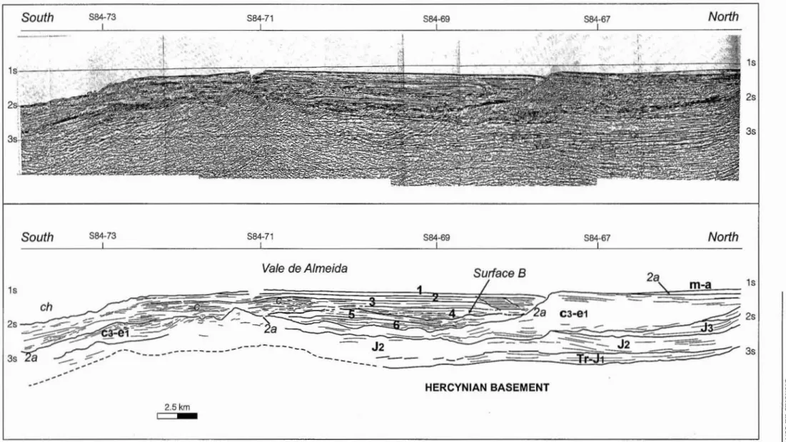
Fig.S•Interpretation of the seismic line 584·72 , on the adjacent area to the SiloVicente submarine canyon. Surface28constitutes Ihc base of the Tertiary packages on the Alentejo Margin. Likewise in Setubal, three mainravinemcnt periods can be identified here: a first coincident with surface 28 (early/middle Oligocene); a second stage materialisedbythe erosional surface separating units 4
and 5; a third stage coincident with the ravincment of the actual canyons (eh). AcompJex pattern of mlnor channels (e) is visible within Unit 3 on Ihe southern part of the Vale de Almeida.
~
,..
I --- -- - - --- - -- - - - ,
West
1s
2s
West
_ L
$84-72
.
_.._.
. .__.._
.
884·70
5 84·70
__
I
m·
East
East
Fig. 6 • Interpreted section of the seismic line 88 4· 69, showing curved linear features resembling rotational slumps and/or post-depositional deformation ofthe sedimentary packages. The deeper thick Tertiary packageis separated from the shelf Miocene to Quaternary units by a fault system(F),trending NNW·SSE to NNE·SSW.
f
.:J
§
. ~
~
o~
I
'-18
28
2.5
km-=- ~~
~ ~
=-_..
~
_ .~ : =
.~ ~ =' ~ ~ ~ _7
-_._--
~ ' ~ '-, "'; ':2:"
,
F
Lower Cretaceous
-Ju rasslc
28
N
relatively minor tecton ic/eustatic pulses (Antunes et al.,
2000). This time interval encompasses UBS 10 of Cunha (1992).
Stage five is materialised by Units 3 to I , interpreted as including deep shclflhemipelagic deposits (fig. 7) . The late Torto nian-Messinia n regression an d subsequent PlioceneQuaternary sealeve l variations were responsi -ble for the onset of the ac tual geo morphology of the margin. Pliocene depo sits arc mostly d istributed over a narrow N-S band on the Alentejo margin, parallel to the actual coas tline . Margin's subsi de nce resumed from Pliocene times to the Ho locene, with subsequent canyons ' headward erosion and incision (Coop ier& Mo ugenot, 1982).
Overlying the fan-shaped units, sub-paral lel horizon-tal packages resembling suspension-transported deposits have been depos ited o n the study areas. Con to uri te deposits may also comprise part of Units 3 and 2. However, linear features similar to rotational slumps, faulting and erosional scars can be particu larly recognised on the east-west oriented seis mic lines (fig. 6). Dating ofthe units is somehow prob lematic, in part due to their similar seismic cha rac ter. Late To rtonian-Messinia n ravi nement was followed by the deposition of deep marine units on the continental slope . In parallel, onse t of tectonic extension on the Alentejo margin created acco mmodation space for the post-Tortc nian units (Mougenot, 1988). There fore, units 3 to I, overlying the late Burdigalia n-Serravalian Unit 4, can be considered as upper Tortonian to Piacenzian in age. The actual morphology of the margin derives from the spatial dis tributio n of these dee p marine units , deposited in fault-bounded regions subside nt since early Pliocene (Mougenot, 1988). Onshore, the post-Tortonian depos itional record is scarce with the exception of conti-nenta l dep osits in the NE part of the Lower Tagus Basin and in the Mondego Basin (Cunha, 1992). The base of Unit 3 can be related with the Betic tectonic phase (Cunha, 1992 ) s ince th is event ha s been re co gnise d as th e responsible for the develop ment of the actual margin's mor pho logy and with a increase of subsidence in the margin (Coopier & Mougeno t, 1982). Although with reserves, the seismic boundaries identified on the seismic data can be also re lated with importa nt strat igrap hic boundaries resulting from tectonic events. Corr elating Units 2 and I with the UBS 12 and UBS 13 respective ly suggests that the base of Unit 2 can result from the Intra-Za nclea n tectonic phase . Foll owing the sa me line of thought, the base of Unit I possibly materialises the Ibcro-manchegan I tectonic phase
(cf
Cunha, 1992) (fig. 2).The sixth evol utionary stage, synchronous with the onset of the present tectonic/geomorphologic conditions, materialises the ravinement of the actual canyon channels (fig. 7). Seismic data reveals a shift in the channels posi-tion from middle Miocene (Su rface B) to the present (fig. 5). In the Vale de Almeida area, the actual channel of the Sao Vicente submarine canyon ravinates the seismic pack-ages deposited over Unit 4.
The Setubal canyon is also presently located on a distinct area from the studied region, and has been con-sidered as a result of Pliocene-Pleistocene glacial-eustatic
Ciencias daTerra(UNL) , 14
events (Coopier& Mougenot, 1982). Messinian and Plio-Pleistocene ravinements in the
Setubal
areas have been controlled, according with the same authors, by the reac-tivat ion of ancient Hercynian faults (Tagus lineament,Grandola
fault). On the interpreted seismic lines, the Sao Vicente canyon seems to follow a tectonic de pression located on the so uth ern flank of the De scobridores seamounts. The seis mic data undernea th the canyon chan-nel does not allow the recognition of complex struc tures below surface 2a (midd le Oligocene erosional surface). However, the struc tura l co mpl exi ty o n the adj acent De sco br ido res se am o unt s incr ea ses , si nce bo th th e Tertiary and Mesozoic units are intersected by several fa ults reactiva te d d ur ing th e al pi ne co mp ress ion (Mougenotet al. ,
1979). On theSetubal
area, the headward erosional part of the canyon is coincide nt with a highly deformed area of the shelf, northeast of the Principes de Avis Seamounts (Line 584-70, fig. 3) . Strong erosio n of the northern flank. of the canyon is also observe d on the seismic da ta, possibly resulting from the activity of sea-bottom currents. From the interp reted data is not possible to interpret the provenance and direction of the currents. Nevert heless, seasonal upwelling along the margin, broad Deep Geostrop hic Curren ts, and important south-north contour currents have been recorded along the Alentejo Margin, the last related with the Mediterranean Deep Water Flow (MDWF) (Lebreiro et al., 1997). Presently, both submarine canyons constitute bypass/ero sional areas in most of their course , with releva nt sediment deposition restricted to the deep areas of the margin close to the slopcJ abyssal plain transition (fig 7).CONCLUSIONS
Seismic reflection data obtained on the Alentejo margin has revea led the exis tence of a co mmon evolutio nary fram ewo rk for the sedi men tary rid ges bounding th e Setubal an d Sao Vice nte canyons . Th ree ravine ment periods have been recognised: a first ravinement proba bly ear ly/middle Oligocene in age; a secon d tentatively dated as Burdigalian; a third Pliocene-Quaternary period respon-sible for the actual location of the canyon-channels. Six seismic units ha ve be en identified in bo th can yo ns, constituting two d istinctive depositional sequences. The importance of the tectonic factors on the canyons' location and development is clear, since they both constitute the geo morph o logica l expressio ns of maj or late-Hercynian faults limiting the Alentejo basin to the north and to the so uth. Bo th canyo n areas are co inc ide nt with highly deformed reg ions of the margin. Their location is also coinciden t with two Mesozoic depocentres, as proved by the thickening of the Jurassic and Cretaceous units towards the zones adjacen t to the canyons. However, no evidences of Mesozoic development of the submarine features have been reco gnised from the data. Onsho re stratigraphy, seismic and well data collected on the continental shelf, allowed to relate the canyons' evolution with the main tectonic and eustatic events affecting the margin from Oligocene to the Present.
CienciaJda Terra(UN!). 14
1. Midd le Oligocene
•
Coo....<,
...2.Chanian-Aq u ilania n to BUrd ig a lian
3 . Int ra- Burdigalian
4. Up per Bu rd ig a lia n to Plioce ne
--
...
5. Up per P lio ce ne to Ho loc e ne
W~ E~ SE
~
...
-Fig. 7 - Geological evolution of the Setubal and Sao Vicente Canyons according with the interpreted seismic and stratigraphic data. Ravinememoranctentcanyon channe ls is suggested to have occurred during the Oligocene erosional period ( I) . A first generation of canyon-fill sediments was deposited between the late Chattian and the lower/middle Burdigalian (2). A second generation of ravinements was originated in the Burdigalian during the paroxismal period of the Neo-Castillan tectonic phase (3). Important subsidence of the margin was recorded then after, with a consequent relative sea-level rise (4). This allowed the filling of the second ge neration of paleo -canyo ns from the Burdi ga lian to Pliocene . Finally, the upper Plioc ene (Pia cenzlan) to Ho locene period is
marked by the erosion of the actual canyon channels (5). ravinating the previously deposited units I to 6.
ACKNOWLEDGEl\IENTS
This work is part of a proj ect spo nsored by the
Pundacao para a Cie ncia e Tecnologia (FCTIMCT),
Project PRAX IS XXI ( BD 13903/97 ). The authors
RE FER ENC ES
Ciencias da Terra(UNLJ, 14
would like to thank the Depar tamento de Geologia
Marinha and
the
Necleopara a Pesquisa e Exploracac
de Petr61e o do In stitute Ge ologico e Mi nei ro
(10M) for permitting de use of the
datamentioned in this
paper.
Andrade, C.F. (193 7) -Osvales submari nos portugueses e 0 di astrofi smo das Berlengas e da Estremadura.Memorias dasServ i~
GeoIOgicos de Portugal, 1, 249 p.
Antunes, M.T., Elderfield, H ., Lego inha , P., Nascimento, A.&Pais,J.(1999) - A stratigrap hic framework for the Miocene from the Lower Tagus Basin (Lisbon ,Se nibal Pen insula, Portu gal). Depositiona l sequences, biostratigraphy and isotopic ages .Revista de
la Sociedad GeolOgica de Espaiia ,vol. 12(1 ): 3-I S.
Antunes, M.T.,Legolnha,P., Cun ha, P.& Pais,J. (2000 ) -Estratigrafia de altaresclueace correlai;:io de facies do Aquitan iano ao Torton iano inferi or de Lisbo aeda Peni nsula de Serubal(Bacia do BaixoTej c,Portu gal).Res umes do I~ Congresso sobre 0
Cenozoica
de Portugal,Lisboa : IS9-166.Boillot, G, Dupeuble,P.-A,Hennequin-Marchand,I.,Lamboy, M.,Lepretre,J.-P.&Musel1ec,P.(19 74) -Lerole desdecrochements "tardi -hercyniens"da nsI'evoluuc nstruc turale de la marge co nti nenta leetda nslalocalisation des gra nds canyons sous- marins a l'Oues terau Nord de laPeninsule Jberique.Revue deGiographie Physiqu eetde Geologie Dynamiql.le,Paris, 16(1 ): 7S-86. Cabral,L ( 1995) - NeoteetOnicaemPortugal Co ntinental.Memorias do
lnsunuo
GeolOgico e Mineiro,31 , Lisboa, 265 p.Coppier,G&Mougenat,D.( 198 2) - Stratigra phie sism iqueet ev oluti on geologique des formations neogenes er quaternaires de la plate-forme co ntinen tale portugaise auSudde Lisbonne .Bulletin de la Societe geologiJlue de Fran ce,24(3 ); 42 1-431 .
Cronin, B.T.& Kidd,R.B. ( 1998) - Heterogeneity and lithotype d istribution in ancient deep-sea canyons; Po intLobesdeep- sea canyonasa reservoir analogu e.Sedimen tary Geology,115; 31 5-349.
Cunha, P.P. ( 1992) - Bstratigrafia e sed imentologia dos depositos do Cr etac tcc S uperior e Terci ari o de Portu gal Centra l, a teste de Co imbra.PhD Thesis,Univcrsidade deCoimbr a: 262 p.
Ercilla, G ,Alonso,8. ,Perez-Belzuz, E,Estrada,E,Baraza , J., Farran,M.,Ca nals,M.&Masson,D.(1998) - Ori gin, sed imen tary p roc esses and de pos itional evolution of the Agad ir tur bidite system, cen tral eas tern Atlantic.Journal ofthe Geological Society,
Lon don,IS5(6); 929-939.
Faugeres, J.-C., Slow, D.AV, Imbert, P., Viana ,A. ( 1999) - Se ism ic features diagnostic of contou nte drifts. Morine Geology,
162: 1-38.
Lebreire, S.M., McCave, N .& Weaver, P.P.E. ( 1997) - late Quaternary turbidi te emp lacement on the Horseshoe abyssal p lain (Iberianmargin).Journol ofSedimentary ReseaTrh,67(5); 856-870.
Maldonado , A.,Somoza,L.,Pallaces, L ( 1999) - The Betic orogen and the Iberian-African boundary in the Gu lf ofCa diz: geologi-calevolution (cen tral No rth Atlan tic).Morine Geology,155: 9 -43 .
Mauffre t,A. , Mougenot, D., Miles, P.R.&Malod , l A. ( 1989) - Ce nozoic deformation and Mesozoic abandoned spreading cen tre in the Tagus abyssal p lain (west of Portu gal): results of a multi chan nel seismi c survey.Canadian Jo urnal of Eanh Sciences,
26: 110 1-1123.
Mi tch um, R.M . (1977). Se ism ic stratigraphy and global changes of sea-level, part 2: Th e de pos itional seque nce as a basi c un it for stratigraphic analysis . In: Payton , C.E. (Edi tor ) Seismic stra tigraphy-Applica tionsto hyd rocarbon ex plorati on.The Amen'can
Association ofPetroleum Geologists Memoir,26: 53-62.
Maugenat, D., Mon teiro , J.H. , Dupeuble, P.A. Ma lod,l .A .(1979) -Lamarge co ntinental sud-Portuguaise: evol ution structurale er sed imentaire.Ciinciasda Terra(UNL),Lisbon, 5: 223-2 46 .
Mougenot, D. (1988) -Geologie de la m4l'fe Portugaise.Th ese de Doctorat D'Etat
es
Sciences Namrell es, Univm;ite Piem: et Marie Curie, Pari s, 15Sp .M ulti, E. ( 1977). Distincti ve thin-bedded turbidite facies and related depositional environments inthe; Eocene Hech e Group (southccntral Pyrenees, Spa in).Sedimentology ,24 : 107- 13 1.
I- Co ngresso sobre o CcnozOico de Portugal
Pimen tel,N.L. (1998) - 'leetono-sedimentary evolution of the Sado Basin (Tertiary, south ern Portugal).A etas do II Congresso NadoflaJde Geologio.,Lisboa,84( 1): 145-148.
Pinheiro, L.M., Wilson, RC.L., PcnadosReis,R , Whitmarsh, RB.&Ribeiro, A. (1996) - The western Iberia margin: a geopbysical and geological overview. In: Whitmarsh, R D., Sawyer, D.S., Klaus,. A., Masson , D.G (Editors).Prot:tediflV
0/
the OceanDrilliflg Program. Sc iefltijic Rntllu,149: 3-23.
Posamentier, H.W.& Erskine, RD. (1991) - Seismic expressio nandrecognition criteria of ancient submarine fans. In: Weimer. P.&
Link, M.H.,Seism ic Facia and &djmenlary Processes o/Submarifle Fans and Turbidue Syslems ,Spinger.Verlag, New Yorlr:: 197·222.
Rasmussen, E.S., Lomho lt, S., Andersen , C.& Vej ba:k ( 1998) -Aspectsof the structura l evolution o f the Lusitanian Basin in Portugal and the shelfand slope area offshore Portugal.Iectonopkystcs,300: 199·225.
Ribeiro, A., Kullberg, M.e ., Kullberg,J.e.,Manuppclla, G , Phipps, S. ( 1990). A review of Alpine tectonics in Portugal: Foreland detachment in basement and cover rocks. In: G Boillol& J.M.Forubote(Ed itors).Tectonophysics,184: 35 7·]66.
Ricci-Lucchi,F.(1975) - Depositional cycles in two turbidite formations of northern Apennines (flaly). Journal ofSed imentary Petrology ,45: 3-43.
Shanmugam, G & Moio la,RJ .(1988) - Submarine Fans : characte ris tics, models, classification, and reservoir pot entia l.
Earth-ScienceReviews ,24: 383 -428.
Vanney, J.· R&Mougenot, D.(198 1)•Laplate.forme continentalede Portugaletles provinces adjace:ntes; Analyse geomorphologique.
Memorias dos Serviros Geol6g icos de Portugal,28, 86 p.
Weimer, P. ( 1991) - Seismic facies. characteristics, and variatio nsinthe channel evolution. Mississ ipifan(plio-P leistocene), Gulfof Mexico. In: Weimer, P.&link, M.H..Seismic Facies andSedi"' ~fllary Processes o/Submarine Fans andTurlJidit~ Systems.
Spinger-Verlag. New York: 323·347 .