André de Sousa Saleiro Barros
Licenciado em Biologia
Upper Jurassic dinosaur bonebeds at Ten Sleep,
Wyoming: stratigraphy, preliminary results and
field reports of 2016 and 2017
Dissertação para obtenção do Grau de Mestre em Paleontologia
Orientador: Octávio Mateus, Professor Associado,
Faculdade de Ciências e Tecnologia da Universidade Nova de Lisboa
Júri:
Presidente: Prof. Doutor Paulo Alexandre Rodrigues Roque Legoinha Arguente: Prof. Doutor Mark Allen Norel
Vogal: Prof. Doutor Octávio João Madeira Mateus
André de Sousa Saleiro Barros
Licenciado em Biologia
Upper Jurassic dinosaur bonebeds at Ten Sleep, Wyoming:
stratigraphy, preliminary results and field reports of 2016 and 2017
Dissertação para obtenção do Grau de Mestre em Paleontologia
Orientador: Octávio Mateus, Professor Associado, Faculdade de Ciências e Tecnologia da
Universidade Nova de Lisboa
Acknowledgments
I start by thanking my supervisor, Professor Octávio Mateus, not only for the help provided during my work, but also for the trust placed in me, for the free range given by him, allowing me to pursue my own objectives, both academically and professionally. I thank the American Museum of Natural History for funding the expeditions which were the focal point of this work, and the Museum of Lourinhã for providing me with a workspace, as well as allowing me to use the laboratorial facilities to prepare the specimens here described. Special thanks to the team members, and visitors, of the expedition, without whom this project would not exit. All fieldwork was carried out under Bureau of Land Manegement permits PA16-WY-245, PA16-WY-255, and PA16-WY-256.
I thank Carl Mehling for his continuous share of information regarding the expedition throughout this work, Alexandra Fernandes for her efforts towards keeping the expedition on track, Alexandre Audigane and Bruno Pereira for providing me with access to the workplace of Museum of Lourinhã, Alexandre Guillaume for making sure no bone was left at risk, Carla Tomás for her teaching and advice on my preparation work, Carole Gee for her identification of the plant material figured in this work, Darío Estraviz, Filippo Rotatori, and Nathaly Rodrigues for their early help with preparation, Francisco Costa for his great work in image and log editing, Marco Marzola for his incredible 3D models, and Vincent Cheng for mapping the quarries during the second year of expedition. I also thank all my friend and colleagues that accompanied me throughout the years for their support.
A heartfelt thanks to Inês Pacheco, for pushing me forward through the last stages of this work, and for her unending source of support and care.
Abstract
The Upper Jurassic Morrison Formation that outcrops throughout the Western Interior of the United States is well known for its diverse environments and for its vertebrate, invertebrate and floral biodiversity, in great part fueled by the numerous paleontological expeditions focused on extensive fossil record of the formation’s dinosaurian fauna, since late 19th century.
In 2014, plans started to be made for a new expedition into the Morrison Fm. outcrops close to the town of Ten Sleep, where digs have been carried out in private land since 2006. This expedition represented the return of the American Museum of Natural History (AMNH) to the Big Horn Basin since Barnum Brown’s Howe Ranch expedition in the early 1930s, however this time, work would be under taken in public land. As such, a project was submitted to the Bureau of Land Management in order to obtain permission to dig and survey two distinct localities between the towns of Ten Sleep and Hyattville: Cosm and Dana quarries. The expedition counted with elements from AMNH and Faculdade de Ciências e Tecnologia da Universidade Nova de Lisboa (FCT-UNL), and was carried out between the months of August and September, of 2016 and 2017.
At the end of two years, the yellowish to tan massive cross bedded sandstones that outcrop along the hills of the Ten Sleep-Hyattville area, have proven to rich fossiliferous riverbank deposits, both in quantity and diversity, mainly preserving dinosaurian remains (some preserving cranial elements) representative of the upper levels of the Morrison Fm. such as Allosaurus sp., Apatosaurus sp., Camarasaurus sp., and unidentified diplodocids, ornithopods, and stegosaurid. This information, along newer stratigraphical data for the area, and the detailed description of the digging season, are here reported as to record the first steps taken in what is to be a long term project.
Resumo
A Formação de Morrison do Jurássico Superior, que aflora ao longo do Oeste Interior dos Estados Unidos, é conhecida pelo seu ambiente diverso e pela sua diversidade de vertebrados, invertebrados e flora, devido em grande parte às várias expedições paleontológicas focadas no extenso registo fóssil dos seus dinossauros, desde finais do Século XIX.
Em 2014 começaram a ser feitos planos para uma nova expedição aos afloramentos da Fm. de Morrison próximos de Ten Sleep, onde escavações têm sido levadas a cabo em terreno privado desde 2006. Esta expedição marcaria o regresso do American Museum of Natural History (AMNH) á Big Horn Basin desde a expedição de Barnum Brown a Howe Ranch no início dos anos 30, mas desta vez com o trabalho a ser realizado em terrenos públicos. Um projeto foi submetido ao Bureau of Land Management de modo a obter permissão para escavar e prospetar dois locais distintos entre Ten Sleep e Hyattville: as jazidas de Cosm e Dana. Esta expedição contou com elementos do AMNH e da Faculdade de Ciências e Tecnologia da
Universidade Nova de Lisboa (FCT-UNL), tendo sido levada a cabo entre os meses de Agosto e Setembro de 2016 e 2017.
Ao final de dois anos, os arenitos castanho claro e amarelados com sedimentação cruzada que afloram nas colinas da área de Ten Sleep-Hyattville provaram ser ricos depósitos fluviais fossilíferos, tanto em
quantidade como diversidade, preservando maioritariamente vestígios de dinossauros (alguns com elementos cranianos preservados), representativos dos níveis superiores da Fm. de Morrison, como Allosaurus sp., Apatosaurus sp., Camarasaurus sp, e ainda diplodocídeos, ornitópodes e um stegossaurídeo por identificar. Esta informação, os novos dados estratigráficos para esta região e a detalhada descrição das temporadas de escavação são aqui reportadas de modo a registar os primeiros passos daquilo que será um projeto a longo prazo.
Abbreviation List
InstitutionalAMNH: American Museum of Natural History, New York City, USA;
AMU: Aix-Marseille Université, Marseille, France;
BLM: Bureau of Land Management, USA;
FCT-UNL: Faculdade de Ciências e Tecnologia, Universidade Nova de Lisboa, Caparica, Portugal;
GMK:GeoCenter Møns Klint, Borre, Denmark;
KU:Københavns Universitet, Copenhaguen, Denmark;
ML: Museu da Lourinhã, Lourinhã, Portugal;
UP: Universidade do Porto, Porto, Portugal;
Table of contents
Acknowledgments ... iv
Abstract ... vi
Resumo ... vii
Abbreviation List ... viii
Table of contents... ix
Table of figures ... xi
1. Introduction... 1
1.1 Morrison Formation synthesis ... 1
1.2 Historical context ... 6
1.3 Big Horn Basin ... 9
1.4 Bonebeds ... 10
2. Objectives ... 12
3. Field Reports (2016 and 2017) ... 13
3.1 Why dig in Ten Sleep? ... 13
3.2 Team members ... 13
3.3 BLM Permits... 15
3.4 Project objectives ... 16
3.5 Inventory and expenses ... 16
3.6 Schedule ... 18
3.7 Dana Quarry ... 18
3.7.1. Description ... 18
3.7.2. 2016 Expedition ... 19
3.7.3. 2017 Expedition ... 20
3.7.4. Findings ... 22
3.8 Cosm Quarry ... 22
3.8.1. Description ... 22
3.8.2. 2016 expedition ... 23
3.8.3. 2017 Expedition ... 24
3.8.4. Findings ... 26
4. Stratigraphical work for the Ten Sleep-Hyattville area ... 27
4.1 Stratigraphic logs ... 28
4.1.1. Section 1: Bobcat Hill ... 28
4.1.2. Section 2: Bobcat hilltop ... 31
4.1.3. Section 3: Cosm Quarry (North) ... 32
4.1.4. Section 4: Cosm Quarry (South) ... 34
4.1.5. Section 5: Dana Quarry ... 36
4.2 Comparison and local correlation with previous works ... 38
4.3 Paleoenvironment ... 40
4.4 Age of Cosm and Dana quarries ... 42
5. Taxonomical description ... 44
5.2 Specimens description ... 46
5.2.1. AMNH FARB 33055 ... 46
5.2.2. AMNH FARB 33058 ... 51
5.2.3. AMNH FARB 33061 ... 54
5.2.4. AMNH FARB 33062 ... 70
5.2.5. AMNH FARB 33072 ... 73
5.2.6. AMNH FARB 33077 ... 74
5.2.7. AMNH FARB 33078 ... 76
5.2.8. AMNH FARB 33079 ... 78
5.2.9. AMNH FARB 33081 ... 79
5.2.10. AMNH FARB 33083... 81
5.3 Taxonomical discussion ... 83
6. Conclusion ... 86
References ... 87
Appendixes ... 95
3A. Permit PA16-WY-245 ... 96
3B. Permit PA16-WY-255 – 2016 ... 99
3C. Permit PA16-WY-255 – 201 ... 102
3D. Permit PA16-WY-256 – 2016 ... 105
3E. Permit PA16-WY-256 – 2017 ... 108
3F. Paleontological locality forms ... 111
3G. Simplified inventory list of used materials throughout the expedition ... 117
3H. Log of expenses for 2016 ... 119
3I. Log of expenses for 2017 ... 122
3J. Team members’ presence sheet ... 126
3K. Cosm Quarry map by Vincent Cheng (2017) ... 128
3L. Cosm-II map by Octávio Mateus (2017) ... 129
3M. Dana Quarry map of theropod assemblage by Vincent Cheng (2017) ... 130
3N. Dana Quarry map of the Apatosaurus specimen by Vincent Cheng (2017)... 131
5A. Specimen Transfer Form for the material collected during 2016 ... 132
5B. Specimen Transfer Form for the material collected during 2016 ... 133
5C. Loan document regarding the Cosm Quarry material prepared at Musem of Lourinhã ... 134
5D. AMNH inventory sheet for the collected fossils of the 2016 expedition ... 136
5E. AMNH inventory sheet for the collected fossils of the 2017 expedition ... 141
5F. Paleo 3-D scanning (non CT) Agreement for AMNH FARB 33058 ... 145
5G. Paleo 3-D scanning (non CT) Agreement for AMNH FARB 33061 ... 146
5H. Paleo 3-D scanning (non CT) Agreement for AMNH FARB 33062 ... 148
5I. Links to 3D models and model quality data provided by Marco Marzola... 151
Table of figures
Figure 1.1: Total expansion of Morrison Fm. deposits and related beds ... 2
Figure 1.2: World paleogeography during the deposition of the Morrison sediments ... 2
Figure 1.3: Evolution of the Morrison Fm. environment through the Kimmeridgian an early Tithonian stages of the Upper Jurassic ... 5
Figure 1.4: Representation of a fluvial and floodplain environment of the Upper Jurassic ... 6
Figure 1.5: Stratigraphic section at the type locality of Morrison Fm.. ... 7
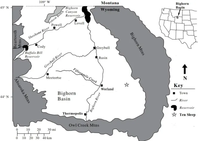
Figure 1.6; Map of the Bighorn Basin, Wyoming, showing the surrounding mountain ranges ... 10
Figure 3.1: All members of the 2016 expedition team at Yellowstone National Park ... 14
Figure 3.2: Part of the 2017 expedition team at Dana Quarry ... 15
Figure 3.3: Aerial view of Dana Quarry 2017 digsite ... 19
Figure 3.4: Aerial view of Cosm Quarry and Cosm-II.. ... 23
Figure 4.1: Stratigraphic Section 1, located on the south facing slope of Bobcat Hill, a few meters north of Cosm Quarry, Big Horn County, Wyoming, USA. ... 29
Figure 4.2: Stratigraphic log of Section 1 ... 30
Figure 4.3: Part of the Stratigraphic Section 2 exposure at the top of Bobcat Hill, Southwest of Cosm Quarry, Big Horn County, Wyoming, USA. ... 31
Figure 4.4: Stratigraphic log of Section 2 ... 32
Figure 4.5: Stratigraphic Section 3, on the norther section of Cosm Quarry in the in the west-facing slope of Bobcat Hill, Big Horn County, Wyoming, USA. ... 33
Figure 4.6: Stratigraphic log of Section 3 ... 34
Figure 4.7: Stratigraphic Section 4, on the southern section of Cosm Quarry in the in the west-facing slope of Bobcat Hill, Big Horn County, Wyoming, USA. ... 35
Figure 4.8: Stratigraphic log of Section 4 ... 36
Figure 4.9: Part of the Stratigraphic Section 5 exposure at the North faced hills of Dana Quarry, Washakie County, Wyoming, USA. ... 37
Figure 4.10: Stratigraphic log of Section 5 ... 38
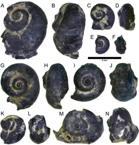
Figure 4.11: AMNH FI 113386 Amplovalvata scabrida specimens collected at Dana Quarry. ... 41
Figure 4.12: AMNH FI 113385 Unio fragments colected at Dana Quarry. ... 41
Figure 4.13: Assorted plant material collected at Cosm Quarry ... 43
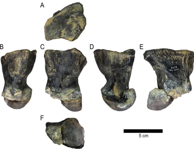
Figure 5.1: Allosaurus sp. AMNH FARB 33055 left metatarsal II condyle ... 47
Figure 5.2: Allosaurus sp. AMNH FARB 33055 left metatarsal III condyle... 48
Figure 5.3: Allosaurus sp. AMNH FARB 33055 phalanx IV-1 ... 49
Figure 5.4: Allosaurus sp. AMNH FARB 33055 phalanx IV-2 ... 50
Figure 5.5: Camarasaurus sp. AMNH FARB 33058 loose pre-max/maxillary tooth ... 52
Figure 5.6: Camarasaurus sp. AMNH FARB 33058 loose dentary tooth ... 53
Figure 5.7: Allosaurus sp. AMNH FARB 33061 left metatarsal I ... 55
Figure 5.8: Allosaurus sp. AMNH FARB 33061 articulated left metatarsals II, III, and IV ... 56
Figure 5.9: Allosaurus sp. AMNH FARB 33061 left metatarsal V ... 59
Figure 5.10: Allosaurus sp. AMNH FARB 33061 left phalanx I-1 ... 60
Figure 5.11: Allosaurus sp. AMNH FARB 33061 left phalanx III-1 ... 61
Figure 5.12: Allosaurus sp. AMNH FARB 33061 left phalanx III-2 ... 62
Figure 5.13: Allosaurus sp. AMNH FARB 33061 left phalanx III-3 ... 63
Figure 5.15: Allosaurus sp. AMNH FARB 33061 left ungual phalanx III ... 65
Figure 5.16: Allosaurus sp. AMNH FARB 33061 left ungual phalanx IV ... 65
Figure 5.17: Allosaurus sp. AMNH FARB 33061 right metatarsal II condyle ... 66
Figure 5.18: Allosaurus sp. AMNH FARB 33061 right metatarsal III condyle ... 67
Figure 5.19: Allosaurus sp. AMNH FARB 33061 left maxillary tooth ... 68
Figure 5.20: Allosaurus sp. AMNH FARB 33062 left metatarsal IV ... 71
Figure 5.21: Allosaurus sp. AMNH FARB 33062 left phalanx IV-1 ... 72
Figure 5.22: Unidentified ornithopod AMNH FARB 33072 isolated pedal phalax ... 73
Figure 5.23: Allosaurus sp.AMNH FARB 33077 isolated tooth ... 75
Figure 5.24: Allosaurus sp.AMNH FARB 33078 isolated tooth ... 77
Figure 5.25: Allosaurus sp.AMNH FARB 33079 isolated phalanx condyle ... 78
Figure 5.26: Allosaurus sp.AMNH FARB 33081 isolated tooth ... 80
1.
Introduction
1.1
Morrison Formation synthesis
Figure 1.2: World paleogeography during the deposition of the Morrison sediments (Tithonian at the top, and Kimmeridgian ate the bottom). Paleomaps from CR Scotese (PALEOMAP Project).
To the North, the Morrison Fm. overlays the Middle and Upper Jurassic deposits of the Sundance sea, while sabkha and aeolian dune facies representative of the sea’s arid shores are can be observed to the South. The overlying terrestrial foreland basin deposits, resulting of the Sevier orogeny, are comprised of grey-purple mudstones, fluvial sandstones, and, coarse conglomerates at their base, making up the contact between the Morrison and overlaying formation. Some authors (Pippiringos & O’Sullivan, 1978; Roca & Nadon, 2007) have correlated the bottom and top limits of the Morrison Fm. to unconformities observable through the western interior, namely the J-5 Unconformity at the base of the formation (although it may also represent the base of the Windy Hill Member), and the K-1 Unconformity at the base of several Cretaceous conglomeratic facies across the western interior.
This formation is characterized by variegated green, grey and red mudstones, tan to white sandstones, and grey limestones. Caliche nodules, reworked clasts, coal rich layers, ash and hard shales have also been recorded in the Morrison sediments. Due to its extent, the Morrison Fm. varies considerably in both in thickness and lithology, which is reflected on the rather large amount of members that have been proposed throughout the years, of which many are only observable, and locally recognizable (Peterson, 1994), at the southern exposures of the area of the Colorado Plateau, being divided into as many as nine distinct members (Foster, 2003). The number of members into which the Morrison Fm. is divided tends to decrease farther North, where many of the member of the Colorado Plateau not being recognizable, with other unformal divisions proposed (Foster, 2003).
Maidment and colleagues (2017) summarize the Morrison members at the Colorado Plateau region into three: Tidwell, Saltwash, and Brushy Basin members. Tidwell Member, at the base of the formation, comprises red-brown mudstones, thin sands, and gypsum, deposited in a sabkha and shallow marine environments, followed by the braided and anastomosing river deposits dominated Salt Wash Member, with a source area to the southwest. At the top of the formation, the Brushy Basin Member is recognized by its floodplain and lacustrine mudstones and sands deposited by low sinuosity, anastomosing rivers, as well as for its highly fossiliferous outcrops from which the majority of the vertebrate fauna is recovered in the Morrison Fm.
1998; Turner and Peterson 1999), and also magnetostratigraphy and sequence stratigraphy (Steiner et al., 1994; Swierc and Johnson 1996; Currie 1997; Currie, 1998; Steiner 1998; Maidment et al. 2017).
Figure 1.3: Evolution of the Morrison Fm. environment through the Kimmeridgian an early Tithonian stages of the Upper Jurassic. Adapted from Parrish et al., 2004.
fauna (crayfish, gastropods bivalves, conchostracans, and ostracods), and the flora (algae, bryophytes, ferns, horsetails, seed ferns, cycadophytes, ginkgos, and conifers), as well as to the several ichnofossils of both fauna an flora found in the Morrison Fm. ( Chure et al., 2006; Foster, 2007). The Morrison faunal and floral diversity have been compared the Lourinhã and Alcobaça Formations of Portugal, and to the Tendaguro Beds in Tanzania, all of which have similar aged deposits, paleoenvironments, lithology, and even sharing approximately 38% of their dinosaurian diversity (Mateus, 2006).
Figure 1.4: Representation of a fluvial and floodplain environment of the Upper Jurassic. Illustration by Mark Hallett (Hallett & Wedel, 2016).
1.2
Historical context
The name of the Morrison Fm. was used for the first time by Cross (1894), in the Pikes Peak atlas sheet, referring to Jurassic shales, marls, and sandstones, outcropping close to the town of Morrison in Colorado, similar to deposits previously described by Hayden (1869) for the Turkey Creek area, Marvine (1874) at Bear Creek, and Marsh’s (1877) “Atlantosaurusbeds”rich in dinosaurian remains.
The first record of work done in the Morrison Fm. comes from discovery of the formation’s first fossil vertebrate remains discovered by the physician and geologist John Newberry in 1859, and later named Dystrophaeus viaemalae Cope, 1877 (Foster, 2007). It would take ten years for new dinosaur remains to be found, and seven more until the Rocky Mountain region to become the focal point of the Morrison Fm. paleontological expeditions. During March of 1877, the discovery of the large sauropod bone assemblage of Como Bluff (Wyoming) discovered by William Reed and William Carlin, Edward Copes’s expedition to recover sauropod bones near Garden Park (Colorado), and the discovery of large sauropod bones on the hill close to Morrison (Colorado) by Arthur Lakes and Henry Beckwith, began a period of frenzied collection of dinosaur material from the Morrison Fm. (Foster, 2007). This period would be known as “Bone Wars”, and was mainly fueled by the competition between Cope and Marsh, resulting in numerous new species being dug and described at a fast pace, and an increased interest by several American institutions on these deposits, one of them being the American Museum of Natural History in New York (AMNH).
The AMNH’s first expeditions to the Morrison Fm. deposits on the Rocky Mountain region took place in the late 1890s and were led by Henry Osborn, at the time head of the vertebrate paleontology program, and focused on the discovery of mammal and dinosaurian remains in the outcrops of Como Bluff, Wyoming, at Reed’s Quarry 9 and 10 (Foster, 2007). These expeditions resulted in the discovery of partial skeletons of Apatosaurus Marsh, 1877b and Diplodocus Marsh, 1878, and one new mammal named Araeodon intermissus Simpson, 1937(Foster, 2007). Reed’s Quarry 9 would be later revisited by the AMNH, alongside Yale Peabody Museum, between the summers of 1968 to 1970, where a greater diversity of fossils were collected, including mollusk, fish, amphibian, turtle, squamate, sphenodontian, crocodilian, and dinosaurian remains, as well as several species of mammals (Prothero, 1981).
Soon after from 1889 to 1905, AMNH crews focused their work on a site in the plains North of Como Bluff named Bone Cabin Quarry. This site proved to be very productive with the crews collecting at least 50 individuals representative of a dozen distinct taxa, such as crocodiles, turtles, and dinosaurs such as Apatosaurus, Allosaurus Marsh, 1877b, Camptosaurus Marsh, 1877, Ornitholestes Osborn, 1903, and Stegosaurus Marsh, 1877a (Foster, 2007). Also in early 1900s, AMNH and Smithsonian crews collected in several quarries in the area of Sturgis, South Dakota, resulting in two Camarasaurus Cope, 1877 individuals and a diplodocid (Foster, 2007)
interlocked with one another and in several states of articulation, belonging to possibly more than 20 individuals, as well as sauropod skin impressions (Brown, 1935). At end of the expedition, the majority of the collected bones were identified as diplodocid sauropods, with other elements found being the remains of Camarasaurus and Camptosaurus, and teeth of Allosaurus (Brown, 1935; Foster 2007).
Although Brown’s expedition to Howe Quarry was the first and last excursion of the AMNH into the area of Greybull, the story was just yet finished. In 1990, a team from Zurich led by Hans-Jakob Siber not only reopened the quarry, but also opened two new quarries, one 450 meters southwest of the original dig site, now known as Howe-Stevens Quarry, and another a few hundred meters from Howe Quarry, nowadays known as the Big Al Site. The former site was located in public land managed by the Bureau of Land Management (BLM), leading to the nearly complete Allosaurus specimen being confiscated by BLM responsible, and sent to the Museum of the Rockies in Bozeman, Montana. The expedition lasted from 1990 to 1999 resulting several dinosaurian individuals such as Allosaurus, Apatosaurus, Barosaurus Marsh, 1890, Camarasaurus, Diplodocus, Dryosaurus Marsh, 1094, Stegosaurus, Othnielia Galton, 1977, and on unidentified sauropod baby (Ayer, 1999).
1.3
Big Horn Basin
The Big Horn Basin is located in North Wyoming, being 193 kilometers long and 96
kilometers wide, and covering an area of around 16093 square kilometers. The basin is bounded to the east and northeast by the Big Horn and Pryor Mountains, south by the Bridger and Owl Creek
Figure 1.6; Map of the Bighorn Basin, Wyoming, showing the surrounding mountain ranges. Modified from Smith et al., 2008.
The surrounding mountain ranges developed during uplifting events of the Laramide orogeny, displacing the broad Cretaceous seas, leading in turn to thick continental sequences to be deposited east of the Great Plains of Wyoming and Montana during the later stages of the Cretaceous, followed by a great fluvial erosion period during the Eocene (Mackin, 1937). The uplift events brought thick series of Paleozoic and Mesozoic sedimentary rocks high above the Great Plains, and observable along the great anticline that forms Bighorn Mountains. Deep erosion of the crest of this uplift, resulted in the exposure of pre-Cambrian granites that make up this mountain range, along with Paleozoic, Mesozoic and Cenozoic exposed sedimentary deposits turn the Big Horn Mountain area into a great case study of stratigraphic relations and variation within the sedimentary basin (Darton, 1906).
1.4
Bonebeds
Rogers & Kidwell (2007) refer to bonebed as a “relative concentration of vertebrate hardparts preserved in a localized area or stratigraphically limited sedimentary unit (e.g., a bed, horizon, stratum) and derived from more than one individual”, and distinguishing two types: macrofossil and microfossil bonebeds.
According to Behrensmeyer (2007), a bonebed is “a single sedimentary stratum with a bone concentration that is unusually dense (often but not necessarily exceeding 5% bone by volume), relative to adjacent lateral and vertical deposits”, with more than one individual represented. He also put a lot of emphasis on the taxonomy the assembled osteological content as a mean to distinguish different types of bonebeds.
Eberth and colleagues (2007) define bonebed “as consisting of the complete or partial remains of more than one vertebrate animal in notable concentration along a bedding plane or erosional surface, or throughout a single bed”, in which “notable concentration” refers to an accumulation that “exceeds the normal (background) occurrence of fossil in the host formation or local strata”. The authors also describe in depth the different ways in which bonebeds can be classified. Regarding the size of the osteological content, Eberth and colleagues (2007) present microfossil bonebeds as sites where more than 75% of its fossil elements have a maximum dimension inferior to 5 centimeters, and macrofossil as sites where more than 75% of its fossil elements have maximum dimension above 5 centimeters.
2.
Objectives
There are three main goals for this thesis:
1) Practical contribute for the preparing, BML permits, fieldwork, field numbering and report of the NOVA+AMNH Wyoming Expeditions;
2) Scientific study of the Ten Sleep bonebeds in their various aspects: stratigraphy, sedimentology, paleontological contents, taxonomical identifications, osteological description, and an attempt to understand the bone bed origin;
3.
Field Reports (2016 and 2017)
This section includes the yearly field report on the 2016 and 2017 expeditions to the Upper Jurassic bonebeds of the Ten Sleep-Hyattville area of Wyoming, USA provided to Bureau of Land Management (BLM) with some updates and improvements.
3.1
Why dig in Ten Sleep?
The NOVA+AMNH Wyoming Paleontological Expeditions started with an invitation by Mark Norell to Octávio Mateus on September 8th, 2014, in New York City, to the lead the excavation of the BLM side of Dana Quarry. Henri Galiano, who conducted the excavations in the private side of Dana Quarry, informed Norell about the potentiality of the site. Octávio Mateus filed the permit to the BLM in 2015. Carl Mehling conducted a visit in the spring of 2016 and a new locality was found with the assistance of Wesley Linster. The first expedition occurred in August and September of 2016.
3.2
Team members
The expedition counted with team members with various nationalities and education levels, mainly from FCT-NOVA and AMNH. The expedition PI is Prof. Octávio Mateus (FCT-NOVA) and as co-applicants in the BLM (Bureau of Land Management) permits are Prof. Mark Norell (AMNH), Dr. Emanuel Tschopp (AMNH and FCT-NOVA), and Carl Mehling (AMNH).
In the field, the 2016 expedition counted with contributions of the following team members (ordered alphabetically):
Alexandra E. Fernandes (volunteer; AMNH);
Alexandre Guillaume (researcher; AMU, ML);
André Saleiro (MSc student; FCT-UNL, ML);
Carl Mehling (researcher and Senior Museum Specialist; AMNH);
Emanuel Tschopp (postdoc and researcher; FCT-UNL, ML, UST);
João Marinheiro (researcher; FCT-UNL, ML);
Marco Marzola (Phd student, researcher; FCT-UNL, GMK, KU, ML);
Octávio Mateus (expedition leader, researcher; AMNH, FCT-UNL, ML);
Figure 3.1: All members of the 2016 expedition team at Yellowstone National Park, from left to right: O. Mateus, E. Tschopp, S. Mateus, A. Saleiro, J. Marinheiro, A. Fernandes, M. Marzola, A. Guillaume, and C. Mehling.
In 2017 the team was:
Alexandra E. Fernandes (MSc student, volunteer; AMNH, FCT-UNL)
Alexandre Guillaume (MSc student, researcher; FCT-UNL, ML)
André Saleiro (MSc student; FCT-UNL, ML)
Carl Mehling (researcher and Senior Museum Specialist; AMNH)
Emanuel Tschopp (postdoc, researcher; AMNH, FCT-UNL, ML)
João Russo (Phd student, researcher; FCT-UNL, ML)
Marco Marzola (Phd student, researcher; FCT-UNL, GF, KU, ML)
Mark Norell (Museum Specialist, researcher; AMNH)
Octávio Mateus (expedition leader, researcher; AMNH, FCT-UNL, ML)
Figure 3.2: Part of the 2017 expedition team at Dana Quarry, from left to right: Lucy, A. Fernandes, M. Marzola, A. Saleiro, V. Cheng, A. Guillaume, C. Mehling, J. Russo, E. Tschopp, and O. Mateus. Photo by Mike Eklund.
The field paleo-related visitors were: Marit Bovee, Brock Sisson, Carole Gee, Martin Sander, Cliff and Rowena Manuel, and Hans-Jakob Siber in 2016; and Will Harcourt-Smith, Jessica Oreck, Ana Sarzedas, Fiona Brady, Brent Breithaup, Erik Deitesfeld, Lowell Dingus, Mike Eklund, and Vivian Pan in 2017.
3.3
BLM Permits
The Bureau of Land Management (BLM) is the federal institution, within U.S. Department of the Interior, that manages all of its public land, administering more than 245.7 million acres (1,001,000 km2) of public lands in the United States, which constitutes about one-tenth of the country’s land mass.[2] Most BLM administered lands are located the states of Alaska, Arizona, California, Colorado, Idaho, Montana, Nevada, New Mexico, Oregon, Utah, Washington, and Wyoming.
In order to dig for paleontological purposes in public land, permissions need to be issued by the BLM validating the work being executed in such areas. In order to acquire these permissions, the applicant must fill out the BLM’s Paleontological Resources Use Permit (PRUP). Personal information regarding the applicant (contact and institutional affiliation) must be given, along with the work site location, the nature of the fieldwork to be undertaken (survey or excavation), purposes and methodology, dates of proposed work, name and address of the collected material repository, and the name of other individuals responsible for the expedition (along with CVs). After the expedition, a field report detailing the work done, as well as new localities found (see Appendix 3F) must be sent to the BLM before the end of the year in which the permit was issued.
PA16-WY-245: permit for paleontological excavation of Jurassic fossil material on BLM-administered land, at Dana Quarry. Issued on 17/08/2017;
PA16-WY-255: permit for paleontological excavation of Jurassic fossil material on BLM-administered land. This permit originally only figured one locality by the name of Dana Quarry, however, another site was discovered after the PRUP’s submission. As to allow us to work on both sites, before the permit was issued, the PRUP was amended to include bot. On the second year of the expedition (2017), this permit only allowed work in Cosm Quarry. Issued on 01/08/2016, and renewed on 06/06/2017.
PA16-WY-256: permit for survey and limited surface collection of Mesozoic outcrops around the Ten Sleep-Hyattville area. Issued on 01/08/2016, and renewed on 16/05/2017.
3.4
Project objectives
The objectives of the NOVA+AMNH Wyoming Paleontological Expedition present in the BLM permit application are as follows:
1) Understanding of the anatomy and taxonomy of the dinosaurs from the Morrison Formation; 2) Understand the stratigraphy, paleoecology and taphonomy of the Morrison Formation, with hypotheses on the presence and the significance of the high number and large size of the bone beds among this formation;
3) Address the phylogenetic position of the diplodocids called “Amphicoelias brontodiplodocus” by Galiano & Albersdörfer (2010).
3.5
Inventory and expenses
Organizing a scientific expedition is an elaborate juggling act requiring a lot of forethought coupled with varied experience, and often even involves spontaneous innovation. The intricacies of each discipline vary widely but even within one area, in this case paleontology, many factors (i.e., where the dig will take place, how long it will be, in what season, and for how many participants) affect all the decisions to be made prior to setting off.
Looking at our first two seasons (three weeks of summer 2016 & four weeks of 2017) collecting in the Late Jurassic of Wyoming, a broad-brush picture can be painted outlining some of the typical concerns for a paleontological field trip. We would be spending a month each time in a hot, dry place but one that could get impenetrably muddy in a sudden storm. On both years, we had a big American/European crew requiring lodging, transportation, and all basic living requirements, expecting to find a good amount of large dinosaur material.
other logistics. Their task began several months prior to departure, when a list was disseminated among the coordinators to begin assembling a general blueprint for what would eventually become a master list of supplies. As an AMNH expedition, we were originating from an institution with many resources and plenty of experience. Some of the needed supplies were directly gathered from the vertebrate paleontology preparation lab (i.e., toilet paper, adhesives, acetone, plaster bandages, burlap, brushes, gloves, foil, Ziplock® bags, markers), also ordering more of the same, where we needed more than was available, plus a lot of our tools and other supplies (i.e., plaster, cooler, jackhammer, geological hammers, chisels, first aid kit). It was helpful to break the supplies into categories like digging equipment, plastering supplies, and safety equipment, and to double-check what would be needed. Across said categories one can break things into consumables (things that will get used up like plaster and adhesives) and non-consumables (things that can be used repeatedly like chisels and the cooler). Everything was cross-referenced against the master supply list as it was being loaded into the field vehicle, and quantities of all supplies were also notated so that a real-time inventory of materials was created. This inventory list was put into an online spreadsheet that could be easily accessed from any location, and simultaneously modified at any time by the coordinators (a simplified inventory list can be consulted in Appendix 3G).
Since the AMNH has a field vehicle, which cuts some of the costs, the material was loaded that up in NYC. Whether using our own or rented vehicles, there is always the substantial gas cost to add to the list of expenses, but unexpected expenses as towing and repairs should always be in the back of the mind. Assembling a team coming from as many places as ours does sometimes takes days of travel, which means accounting for room and board along the way, with some of the airfares also being covered. If one’s expedition is to a very remote place, there might not be much expenditure of money along the duration of the trip because you will have had to bring everything along at the beginning. Luckily, our expedition was close to facilities where we could buy our food while out there, replenish any consumable supplies we run out of, and purchase any extra or replacement tools or other things or services we find we need along the way. Moreover, since we were staying at a house, we were able to arrange certain items, like plaster, to be shipped directly to us.
the upcoming season, they can easily add this to the spreadsheet from anywhere, anytime, and with the other coordinators being instantly alerted to the change.
Some significant things separate the expenses of our two trips. A larger portion of the funding provided for first expedition was spent on non-consumables, prior to the start of fieldwork. The 2017 field season ran one week longer than the previous year with several new expenses arising due to the needed to upgrade the size of the storage unit maintained near our sites (in which we store supplies and sometimes specimens), and to hire someone to use a backhoe (for exploratory digging, refilling the holes made in, and to move out largest jacket), and a helicopter (to airlift out the large jackets).
The expenses of the first 2 years of this expedition were handled directly by the AMNH. Aside from what was acquired directly from the AMNH preparation lab, or purchased through it, the 2016 expedition cost about $23,000 USD, while the 2017 expedition cost 31,327.34 USD (for detailed expenses logs consult Appendixes 3H and 3I).
3.6
Schedule
On the first year of expedition, 2016, the fieldwork started on 29th of August, lasting until the 15th of September. In 2017, it started on the 16th of August, and lasted until the 9th of September, with three days of break in between. The two years of expeditions totaled 39 days, with approximately 265 hours of work: 118 hours in 2016, and 147 in 2017. Two tables detailing team members’ presence on the field can be consulted, as sent to BLM, on Appendix 3J.
3.7
Dana Quarry
3.7.1.
Description
This site is located in the Washakie County, between the towns of Ten Sleep and Hyattville, with a fence running across part of the quarry, dividing it in two distinct areas: one, south of this fence, being private property, and another being public land under the administration of the BLM, in which our expeditions took place.
Carpenter et al., 2001; Ornitholestes n. sp.; Othnielosaurusconsors (Marsh, 1878); and Torvosaurus sp. Galton & Jensen, 1979. Other fossil remains mentioned in their work include a nearly complete skeleton of an unidentified turtle, and plant material representative of horsetails, ferns, cycads, and several families of conifers, plus an assortment of fossilized seeds and cones.
Figure 3.3: Aerial view of Dana Quarry 2017 digsite. Drone picture by Erik Deitesfeld.
3.7.2.
2016 Expedition
Work in Dana began with a survey of the area in which we were permitted to dig. The purpose of this action was to find a site where bones were exposed, and while doing so, collect loose bone fragments that might provide valuable taxonomic information.
thinner), fill fractures on the bones, and/or glue fragments of bone that may have broken (thicker due to a higher concentration).
As soon as the bones of this specimen were fully exposed, their positions on the matrix were photographed as well as their relative position to each other before their removal began, in order to avoid losing any spatial information since the bones needed to be retrieved in different blocks. To do so, a trench was dug around and between the bones, creating a chalice-like structure on the rocks. After this, the exposed bones were covered with tinfoil before being encased in a plaster jacket. Once the plaster was dry, the foot of the chalice was broken and the block flipped in order to repeat the process on the other side. The blocks were identified with a field number and a date of collection on both sides of the plaster jacket. Before leaving, the team covered the site again with the overburden with the help of buckets, shovels, and hoes.
It should be noted that little work was done in Dana by the team this year, in part due to not having suitable equipment, such as a backhoe to dig the hard sandstone in which the bones were preserved, and the lack of shelter in an area without any shade, making the working conditions harsher.
3.7.3.
2017 Expedition
Just like the previous year, we started our work in Dana by surveying for exposed bones in the light brown sandstone layers, in order to find a good place to start our digging efforts. From this survey resulted two possible dig sites, both bearing sauropod remains on the surface.
The located close to the fence, that divided the BLM side of Dana from the private side, proved not only more interesting, as theropod remains were found very close to the sauropod bones already observed, but also allowed an easier access for the backhoe provided by the Tanners.
The use of the backhoe had been previously discussed with the BLM, since it would make it easier to open a quarry in this hard sandstone. With the backhoe part of a big sauropod limb bone was discovered, although the bone shaft was in poor condition. After this, a tarp was set in place over the area surrounding the bone and the team started picking the bone fragments belonging to the sauropod bone, as well as the many theropod bone fragments, and storing them in Ziplock® bags and cleaning the quarry using shovels, brooms, draw hoes, and dustpans.
During the cleaning process more bones started to become visible, both the sauropod and theropod, making the site become four times bigger that it was originally. Most of the bones found bared several cracks, some being held together only by the matrix surrounding the bones. As such, the area close to the bones was cleaned using the smallest brushes at hand, and a large amount of Paraloid B-72® diluted in acetone was applied to not only protect and consolidate the exposed bone surface, but as an attempt to fill the crack as fissures of theses bones.
as the fossiliferous sandstone layer bared mudstone lenses on some parts of the quarry, but also because the fragility of the bones required us to use less aggressive digging methods.
Once most bones were exposed and consolidated, and the quarry cleaned, some metal stakes were hammered into the ground to serve as reference for mapping the quarry, where the first one to be placed is the main reference steak of which the placement of all other reference stakes is dependent. After the main reference is placed and its coordinates noted down, a second one was placed 3 m from the main stake in the North cardinal direction, and a third one placed 32 meters from the main stake in the East cardinal direction, before several other references were put in place. The map was drawn onto sheets of millimetric paper with a 1:5 cm scale using a 1x0.5 cm grid sub divided in 10x10 cm squares. The several pieces of the map were then copied by hand onto tracing paper with thick black contours outlining the fossils, and then digitalized (see Appendixes 3M and 3N). With the quarry mapped, some blocks were individualized and plaster jacketed, with anatomical, taxonomical, and numeral identification written on both sides of the jacket, as well as the day of collection. Most blocks collected to the cars either by hand or with a net (sometimes requiring the use of the octopus), however, the sauropod material, due to its size and state of preservation, required to be collected as one single 3x1.5 m block.
In order to collect this block, a trench with approximately 90 cm in depth was dug around the articulated bones. The exposed bones were covered with wet toilet paper and, once it dried, the top surface of the block was covered with two layers of plaster and burlap, and two 4x4 wood beams. These beams were placed parallel to each other on top of the block and covered by plaster and burlap in order to make sure they remain attached to the jacket. Then we started to undercut the sediment and dig a tunnel at its midpoint, making the block stand on to columns, after which we started to apply plaster-covered burlap on these undercut surfaces in order to make the whole block more stable before it was flipped. As soon as the plaster dried, we used the remaining wood beams as lever to flip the block, and, after it was flipped, we finished the jacket by applying several layers of plaster and burlap on top of the block, and properly identifying it.
Before closing this site the bones that were still exposed and not going to be collected got covered by wet toilet paper and plaster. Once the plaster were dried, they were covered with an erosion mat, held to the ground by biodegradable stakes, and then hidden with the overburden created during the expedition, in order to leave no traces of our work.
The collected material from Dana was then stored in a storage unit on the outskirts of Ten Sleep, along with the material collected in Cosm and all the expedition equipment.
3.7.4.
Findings
During the first year of excavations not much was discovered in the surveyed area of Dana, with the only material of notice being two limb bones possibly belonging to a stegosaurid. However, the 2017 expedition proved to be more fruitful as we found sauropod material, including the remains of a camarasaurid and the articulated remains of an Apatosaurus-like diplodocid, next to the remains of an allosaurid, and several bones belonging to a small coeluraurid theropod preliminarily identified as Ornitholestes (from a different locality in Dana).
3.8
Cosm Quarry
3.8.1.
Description
Cosm Quarry is located close to the southern border of Big Horn County, northwest from Ten Sleep, near an area known to the locals as Bobcat Hill/Ridge.
The quarry site is a very recent discovery. It was reported to Carl Mehling during his first visit to the region in the summer of 2016, while checking on the Dana Quarry outcrops, by a local named Wesley Linster. Mr. Linster, locally known for digging dinosaur remains in Dana and other sites on the farmland belonging to the Tanner family, took him to an area of this hill where several bone fragments were visible along the face of the hill. These fragments were in a very bad state, with most being discolored due to long exposure to the sun, and not preserving any bone surface.
The only thing of notice were a couple of bones in a yellowish brown sandstone layer, protected bellow a tree root from being washed away by the upper layers’ overburden. The bones preserved both their surface and color, and at first sight looked to be part of a jaw belonging to a theropod dinosaur, possibly Allosaurus.
Figure 3.4: Aerial view of Cosm Quarry (red and yellow tarp) and Cosm-II (blue tarp on the right). Drone picture by Erik Deitesfeld.
3.8.2.
2016 expedition
Before any work could be done on this site, some preparations needed to be made. A safety rope was tied around a tree on top of the hillside in order to make our descent with the tools a bit easier. After that, a tarp was set, not only to provide the team with some shade, but also to give some cover to the tools while they were left in the field overnight.
While these safety measures were being taken care of, part of the team was scattered on the hillside of the site ground looking and picking for loose bones and fragments, collecting them into sample bags.
Cleaning the hillside was not an easy task due to the fact the draw hoe and brooms we were using not only removed the soil covering the rock, but also made it possible for the soil of the top of the hill to slide down to our level. This resulted in a stable and strong foothold on the side of the hill (since the soil that came down made an overhang at the base of the dig site) and resulted in a good exposure of several layers of bone. In fact, most of the bones preserved in these layers were found during this cleaning phase.
but to use a jackhammer powered by a portable generator. This generator was put on the top of the hill, with a tarp below it in order to prevent it from leaking oil into the ground, being only fully covered by the tarp when it was not being used.
Another thing to be noted is the fact that many of the fossils found while digging either presented fractures or were on the verge of breaking, therefore high quantities of thick Paraloid B-72™ were applied to said bones as soon as any signs of weakness were shown. These weaknesses were caused not only by the sedimentary environment in which they were deposited, but also by several veins of gypsum crystals that sometimes filled the fissures and cracks of the bones.
As new bones were being found, a field number was given to isolated bones or to groups of bones, whether they were collected or not. Photos were taken as a record and their relative positions recorded on a simplified dig site map.
The method used to collect big blocks of rock with bones was the same applied to the Dana Quarry material (plaster jacketing). For smaller blocks, instead of using burlap and plaster, medical bandages were used, while isolated or small bones were either enveloped in toilet paper and paper tape or tinfoil and duct tape or simply put in a sample bag. To carry the bigger blocks up the hill a net was used to make it easier for several people to transport them to the cars, as well as ropes and tools with sturdy handles (shovels and brooms).
This site was also very rich in layers filled with plant material. Most of it was collected due to the extraction of blocks from the ground, while some just happened to dissociate from the layers during the cleaning process. However, to collect this material we had to keep in mind not to cover it with Paraloid B-72™ (so the cuticle, if present, could remain intact) and always envelope the material collected in toilet paper (in order to avoid even more weathering of the already fragile structures).
Before closing down the dig site for this season, all of the exposed bones that were not collected were covered with wet toilet paper, followed by plaster to protect them until the next digging season. Before the plaster was fully dried, loose soil was dusted over it in order to give it a darker colour thus making it easier to disguise. Once this was done, we made the upper layer of soil slide down the hill using shovels, brooms, and draw hoes, covering all digging traces that could still be seen.
As for difficulties faced while digging on this site, the main one was the inclination. This not only delayed our work a bit (as we dug the lower fossiliferous layers the soil was covering, the soil layers above would eventually slide and cover them) but also made it difficult to make a proper field map due to the overlay of exposed bones and the quarry’s surface inclination.
3.8.3.
2017 Expedition
Unlike the previous year, it was decided that the best way to work on this quarry would be a top-down approach. As such, the use of the generator powered jackhammer in order to dig the harder sandstone overlaying our fossiliferous layer. As this layer was being dug, the resulting overburden was being removed from the dig site with shovels and draw hoes in order to keep the fossiliferous layer and plaster protection visible. This resulted in a vertical cut of ~3 m high, and a more horizontal exposure of the first fossiliferous layers to serve as our digging area.
To level out the surface area we required pickaxes, big chisels, screwdrivers, mallets, geological hammers, and shovels to move the harder sediment and to start trenching the big blocks jacketed in 2016. As we got closer to the newly exposed bones and the plaster-caped bones from the previous expedition smaller chisels and mallets, screwdrivers, gardening shovels, knives, and brushes were used as digging tools.
Some of the bones from the 2016 expedition had to be uncapped as the paper used as a barrier between the bones and the plaster had been consumed by termites, making some of the plaster caps become looser and unfit to be used as part of a plaster jacket. Most of this uncapped bones, as well as some of the newly exposed bones, required either consolidation of fissures and cracks or to be glued back together. Paraloid B-72™ was applied in several concentrations depending on the task: more diluted to fill small fissures and consolidate the bone surface, and thicker concentrations used to fill cracks and to attach bone fragments back together.
The flatness of this year’s dig site made it possible to draw out the quarry map. The method applied was the same as the one used in Dana: several reference metal stakes put in place, with their position based the main (and permanent) reference, then, using the same grid, the exposed bones an jackets were drawn onto millimetric paper using a 1:40 cm scale. The map was eventually copied to tracing paper, using a black marker, and digitalized (see Appendix 3K).
While surveying the hillside for other exposures of the yellowish brown sandstone layer we had been focusing our work on, a new outcrop of this fossiliferous bed was discovered and nicknamed Cosm-II. At first, only some bone fragments were visible on the loose soil and some worn out bones sticking out the sandstone, but after the soil was removed, several bones in situ were exposed along an almost vertical wall, spanning 17 meters wide and 3 meters high. This sandstone layer bared several cracks and shifted blocks resulting in the poor state of preservation of some of the bones here preserved. As such, after the surface was cleaned, using brooms and brushes, all exposed bones were consolidated using Paraloid B-72™ and a field sketch was made of the vertical wall at 1:20 cm scale in order to record the relative position of the visible bone surfaces (see Appendix 3L).
block or being poorly attached to the matrix, were dug, using small chisels and hammers, dentistry tools, and brushes, and collected.
Towards the end of the dig, some blocks started to be isolated, jacketed, properly identified, and transported uphill to the cars, with two of these being left at the foot of the hill in order to be picked up by helicopter due to their weight, while some of the smaller bones and plant material were collected to labeled sample bags. Similar to the year before some of this material was wrapped in either toilet paper and paper tape or toilet paper and duct tape, and properly labeled afterwards.
The exposed bones in both Cosm and Cosm-II that would not be collected were covered with wet toilet paper and plaster, and dusted over with loose soil. Afterwards, erosion mats were spread over the digging areas of the quarry and nailed to the ground with biodegradable stakes, and covered with the overburden and overlaying loose soil.
3.8.4.
Findings
4.
Stratigraphical work for the Ten Sleep-Hyattville area
The first records of stratigraphical work focused on the Morrison Fm. in Ten Sleep area come from the work of Darton (1904) on the stratigraphical comparison of the Big Horn Basin with other geological regions of Wyoming and Colorado. He briefly describes the Morrison Fm. in this basin as easily recognizable, with features shared with outcrops of the Black Hills area and Colorado, dominated by pale green or maroon chalky shales with massive or joint clay structure, also bearing darker clays towards the top levels, and light gray to buff sandstone beds. He would later write about the geology of the Big Horn Basin (Darton, 1906), where he described the Morrison Fm. outcrops in different locations of the basin. He observed that in this area of Wyoming, the fluvial sediments of this formation were overlaying the marine Jurassic sediments of the Sundance Fm., and underlying the Cretaceous sediments of the Cloverly Fm. He also documented the first stratigraphical sequence of the Morrison Fm. outcrops, around 250 feet thick (~76.2 meters), West and South of Ten Sleep, where five different units were recognizable: greenish-gray to reddish sandy shale, sandstone, maroon to red clays, greenish-grey clays, and grey shales (top-to-bottom). Mook (1916) would later represent this outcrop in the form of a simplified geological log in study of the Morrison Fm.
Lee (1927) in is attempt at correlating the geological formations of Colorado, Wyoming, and Montana, observes 262 feet (~79 meters) of the variegated shale and sandstone units of the Morrison Fm. at a cut west of Ten Sleep, and being overlain by a yellow to brown, coal-bearing, conglomeratic sandstone of the Kootenai Fm. He also took note of dinosaur bones on the Morrison sandstones, and fresh-water bivalve shells 50 feet (~15 meters) from the top. He also observed these units north of Ten Sleep, in cuts close to Hyattville and Bonanza, with the latter exposure showing the shale of the Morrison Fm. overlain by a brown conglomerate unit, similar to what the author observed in Thermopolis, on the southern portion of the Big Horn Basin. Wilson Jr. (1938) also took note of the Morrison sediments 1 mile west (1.6 km) of Ten Sleep, south of the Tensleep fault, observing a 185 feet (~56 meters) thick exposure of maroon shales, variegated brown, gray, and green shales with thin sandstone layers, and black shales.
The last record of stratigraphical work on this area comes from Ostrom’s (1970) work focused on the early Cretaceous Cloverly Fm., and its overlaying and underlying formations, Skyes Mountain and Morrison (respectively), where he revisits and re-describes the outcrops previously described by Darton (1906), Lee (1927), and Mirsky (1962). He describes only three layers for the Morrison at the Ten Sleep cut (66 meters thick, in a total of 104 meters of exposure), with the lowest being an yellow to greenish-gray, silty or sandy, unstratified, calcareous claystone, with occasional thin yellow or buff sandstone lenses. Overlaying the previous layer, is an yellow to white, medium-grained sandstone, with quartz and white chert, cross-laminations, and massive bedding, which in turn is underlying an unstratified and nonfissile variegated claystone (greenish to yellow-tan in upper part, orange to pale-red in lower part) with several yellow or tan sandstone and siltstone lenses. At the Hyattville cut, however, the Morrison is only represent by only 9.40 meters of a white to light-gray, massive, fine to medium-grained, well cemented and prominent sandstone, with quartz, white chert and feldspar in its composition, as the underlain sediments are described to be concealed by valley alluvium.
4.1
Stratigraphic logs
During the two years of expedition, a total of five stratigraphic logs were made of outcrops close to the digging sites of Cosm and Dana in order to better understand the placement of the quarries’ fossiliferous layers within the Ten Sleep-Hyattville area of the Big Horn Basin, and the Morrison Fm, by comparing them to previous reports on the area, as well as to try and correlate the two quarries. Of the five stratigraphic logs, only one is representative of Dana Quarry, with the others representing outcrops in the Bobcat Hill area (two of which are logs of the North and South sections of Cosm Quarry).
4.1.1.
Section 1: Bobcat Hill
The exposure at Bobcat Hill (Figures 4.1 and 4.2) has the following stratigraphic sequence, from base to top:
L1: greenish grey sandstone (thickness: 15 meters);
L2: brownish grey claystone, compact and fine-grained (thickness: 4.05 meters); L3: light grey claystone, slightly sandy, coarse-grained (thickness: 7.20 meters); L4: red claystone, fine-grained (thickness: 8.85 meters);
L5: light tan sandstone, coarse grained, with millimetric fine-grained laminae (thickness: 0.60 meters);
L6: light grey sandstone, medium-grained (thickness: 4.05 meters); L7: yellowish grey sandstone, fine-grained (thickness: 1.95 meters); L8: grey claystone, compact, fine-grained (thickness: 1.95 meters);
L10: dark grey claystone, compact, fine-grained (thickness: 4.05 meters);
L11: variegated purple and dark grey claystone, compact, with the grey portions of this layer being slightly finer than the purple ones (thickness: 2.10 meters);
L12: purplish grey claystone, compact, fine-grained (thickness: 3 meters);
L13: whitish gray sandstone, coarse-grained, with cross bedding (thickness: 0.3 meters); L14: variegated purple and dark grey claystone, fine-grained, with rare millimetric orange claystone laminae (thickness: 3.90 meters);
L15: light grey claystone, compact, fine-grained (thickness: 3 meters);
L16: yellowish brown sandstone, compact, coarse to fine-grained, conglomeratic towards the bottom (pebbles not larger than 1 centimeter, held together by a coarse dark orange to yellowish brown coarse sandstone matrix), with crossbedding, bearing vertebrate and plant fossil remains, and gypsum crystals inside fractures (thickness: 3.30 meters);
L17: yellowish brown to light tan sandstone, medium to fine-grained, bearing bone fragments (thickness: 8.10 meters);
L18: yellowish brown sandstone, compact, coarse to medium-grained, (thickness: 2.75 meters); L19: light tan sandstone, very fine-grained, with bone fragments at the surface (thickness: 3.90 meters);
L20: dark tan sandstone, coarse to medium-grained (thickness: 3.60 meters); L21: dark grey muddy sandstone, fine-grained (thickness: 1.35 meters exposed);
L22: whitish to light grey sandstone, orange to tan on the surface, low carbonate content close to the top, conglomeratic towards the bottom contact (pebbles not larger than 2 centimeters, held together by a coarse grey sandstone matrix), very compact, fine-grained, with crossbedding, and large tabular concretions up 1 meter in diameter (thickness: 5.40 meters).
4.1.2.
Section 2: Bobcat hilltop
The exposure at the top of Bobcat Hill (Figures 4.3 and 4.4) has the following stratigraphic sequence, from top to base:
BH-1: whitish to light grey sandstone, fine-grained, erosive bottom contact (thickness: 50 centimeters);
BH-2: light grey sandstone, very coarse-grained, gravelly to conglomeratic, matrix supported (50% clasts and 50% matrix), and irregular bottom contact (thickness: 20 centimeters);
BH-3: whitish grey sandstone, medium to fine-grained, with cross and planar bedding, alternating polarity of clasts, and irregular bottom contact (thickness: 1.20 meters);
BH-4: light grey sandstone, coarse to fine-grained, with planar bedding, and slightly irregular and sharp bottom contact (thickness: estimated 40 centimeters);
BH-5: grey sandstone, coarse to conglomeratic, pebble supported (55% clasts, 45% matrix, and high lateral variation), with cross bedding, thin fine-grained sandstone lenses, and planar bottom contact (thickness: 1.80 meters);
BH-6: light grey sandstone, medium to fine-grained and coarser towards the top, with planar bedding at the base and three distinct laminae (red, orange, and yellow), reversed grading of the clasts, and sharp to slightly irregular bottom contact (thickness: 80 centimeters).
Figure 4.4: Stratigraphic log of Section 2 exposure at the top of Bobcat Hill, Southwest of Cosm Quarry, Big Horn County, Wyoming, USA.
4.1.3.
Section 3: Cosm Quarry (North)
CQ-N 1: tan sandstone, medium grained (unknown thickness);
CQ-N 2: orange pebble supported conglomerate, with sandy matrix and tan sandstone lenses, preserving bone fragments (thickness: 25 centimeters);
CQ-N 3: yellowish brown sandstone , coarse to fine-grained, compact, with a conglomerate lens at 5 centimeters from the base (both 10 cm thick, pebble supported, orange sandy matrix, preserving bone fragments), bearing plant and vertebrate fossil remains (thickness: 65 centimeters);
CQ-N 4: Tan sandstone, medium-grained, very compact, with conglomerate intercalations at the base, and 60 centimeters from the top (both 5 cm thick, pebble supported, orange sandy matrix, preserving bone fragments), mudstone lens overlaying the bottom conglomeratic one (preserving amber fragments), bearing plant and vertebrate fossil remains, and gypsum crystal (thickness: 1.50 meters);
CQ-N 5: grey sandy mudstone, medium to fine-grained, with large white clasts between 5 and 12 centimeters in diameter (thickness: 2.60 meters);
CQ-N 6: yellowish brown sandstone, compact, coarse to medium-grained, (thickness: 2.20 meters)
Figure 4.5: Stratigraphic Section 3, on the norther section of Cosm Quarry in the in the west-facing slope of Bobcat Hill, Big Horn County, Wyoming, USA.
Figure 4.6: Stratigraphic log of Section 3, on the norther section of Cosm Quarry in the in the west-facing slope of Bobcat Hill, Big Horn County, Wyoming, USA.
4.1.4.
Section 4: Cosm Quarry (South)
The exposure at the South section of Cosm Quarry (Figures 4.7 and 4.8) has the following stratigraphic sequence, from base to top:
CQ-S 1: tan sandstone, medium grained and erosive upper contact (thickness: 40 centimeters of exposure);
CQ-S 2: yellowish brown sandstone, coarse to fine-grained, compact, bearing vertebrate fossil remains, with greenish grey mudstone pockets, and planar upper contact (thickness: 25 centimeters);
CQ-S 3: tan sandstone, medium-grained, compact, with greenish grey mudstone at the base (close to 5 centimeters thick), and planar upper contact (thickness: 20 centimeters);
CQ-S 5: tan sandstone, medium-grained, compact, bearing vertebrate fossil remains close to the top and bottom of the layer, with greenish grey mudstone at the top, and erosive upper contact (thickness: 30 centimeters);
CQ-S 6: yellowish brown sandstone, coarse to fine-grained, compact, bearing vertebrate fossil remains, with crossbedding and wave lamination towards the top, gypsum crystals filling in the fractures, and erosive upper contact (thickness: 45 centimeters);
CQ-S 7: yellowish brown sandstone, coarse to fine-grained, compact, bearing vertebrate fossil remains, with greenish grey mudstone lenses, and erosive upper contact (thickness: 60 centimeters);
CQ-S 8: grey to tan sandstone, medium to fine-grained, very eroded surface (thickness: approximately 1 meter).
Figure 4.8: Stratigraphic log of Section 4, on the southern section of Cosm Quarry in the in the west-facing slope of Bobcat Hill, Big Horn County, Wyoming, USA.
4.1.5.
Section 5: Dana Quarry
The exposure at the northern slope of Dana Quarry (Figures 4.9 and 4.10) has the following stratigraphic sequence, from base to top:
DQ 0: grey to brownish grey cross-bedded sandstone, carbonate, fine grained, with ripple like structures at the top of the layer, suggesting a southbound current, and scarcely preserving bivalve fossils (thickness unknown);
DQ 1: grey muddy sandstone, coarser toward its base, and showing some bedding structures (thickness: 2.40 meters);
DQ 2: grey sandstone, with thin mudstone intercalations, and ripple structures indicating an East-to-West oriented flow (thickness: 50 centimeters);
DQ 4: intercalating red and grey sandy mudstone, sharp upper contact, bearing thin grey sandstone lenses, and with fossilized wood remains observed at the top of the layer (thickness: estimated 8.60 meters);
DQ 5: grey mudstone, with thin sandstone lenses intercalations (from 50 to 150 centimeters above its bottom contact, and from 10 to 80 centimeters bellow its upper contact), and with cross bedding towards the top (thickness: estimated 4.30 meters);
DQ 6: grey mudstone, with thin tan sandstone laminae, gastropod and bivalve fossil remains, and theropod remains close to the upper contact (thickness: estimated 10.20 meters);
DQ 7: yellowish brown sandstone, coarse to medium-grained, eroded at the surface (sometimes fully covered by vegetation), and bearing vertebrate fossil remains (thickness: estimated between 5 and 10 meters).
Figure 4.10:Stratigraphic log of Section 5 exposure at the North faced hills of Dana Quarry, Washakie County, Wyoming, USA.