USE OF ARTIFICIAL NEURAL NETWORKS AND GEOGRAPHIC OBJECTS FOR CLASSIFYING REMOTE SENSING IMAGERY
Texto
Imagem


Documentos relacionados
Linking geomorphologic knowledge, RS and GIS techniques for analyzing land cover and land use change: a multitemporal study in the Cointzio watershed, Mexico.. Maps of land cover
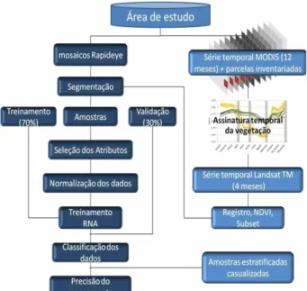
In the Machadinho d’Oeste study area, the 2001 Landsat ETM image was used to conduct land use/ cover classification, consisting of 12
The aim of the present study was to map land use capability for Minas Gerais state, Brazil, following the criteria adapted to different levels of management and measure the accuracy
The proposed model of two professionalism models (Evetts, 2010, p.130): organ- isational-based professionalism and occupational-based professionalism in knowledge societies is
In this context, this study presents a proposal for the conceptual modeling of the integrated use of agricultural land suitability methods to develop support
The main objective of this study was to assess the impacts of land use and land cover change impact on the stream flow of Gilgel Abbay watershed using Remote
This study attempts to analyze land use land cover change and its impact on soil erosion process by applying and adopting commonly used satellite remote
For the purpose of this study, the quantita- tive assessment of changes in land use and land cover- age between 1979-2004 focused on the land immediately around
