Off-print of
Journal of Iberian Archaeology
Volume 1 - 1999
Published by
ADECAP
Rua Anlbal Cunha, 39 - 3° - Sala 7
4050 Porto - Portugal
THE ROMAN TEMPLE OF SCALLABIS
(SANTAREM, PORTUGAL)
by
Ana Margarlda Arruda* & Catarina Viegas*
Abstract: Recent archaeological work in the Alca~ova de Santarem (1994-96), on an estate.which was being transformed into a Touristic Development, revealed the podium of a Roman Temple. The most important feature consists of an almost square construction. measuring 15.45 x 15.25 meters. corresponding to 52 Roman feet; the best preserved facade has a maximum height of 4 meters. On account of the continual occupation of this area. several parts of the temple were destroyed.
Material culture related to the podium allows its construction to be dated in the last quarter of the I" century B.C. Given that it is so rare and well preserved. the importance of this feature is unquestionable in the context of classical architecture in the Iberian Peninsula. Similar temples can be found throughout the Roman empire and the historic context in which the Roman temple of Scallabis was built is analysed using both the archaeological and literary data available.
Key-words: Roman temple; Scallabis; Santarem; religion; architecture.
Resumo: Recentes trabalhos de arqueologia na Aka,<ova de Santarem revelaram 0 podium de urn templo romano. A estrutura consiste numa constru~iio maci~a, de forma geral quadrangular. que mede 15.45x l5.25m. 0 que corresponde a cerea de 52 pes romanos. A fachada melhor conservada possui de altura maxima 4 m.
A ocupa~ao continuada do sftio foi certamente responsllvel pelas grandes destrui~oes que 0 templo veio a sofrer.
A cultura material recuperada, aquando das escava~oes. permitiu-nos datar a sua constru~iio do ultimo quartel do seculo I a.c. Neste trabalho, ensaiam-se interpreta~oes para a sua edifica~lio, nao perdendo de vista os dados que as fontes classicas nos transmitiram sobre Scallabis. e ainda os que os trabalhos de arqueologia nos proporcionaram. Deu-se particular aten,<ao
a
cronologia e 11 tipologia dos templos semelhantes no contexto do imperio romano.Palavras-chave: Templo romano; Scallabis; Santarem; religiao; arquitectura.
* UNIARQ researcher. Centro de Arqueologia, Faculdade de Letras. P 1699 Codex, Lisbon,
Portugal.186 Ana Margarida Arruda & Ca/arina Viegas
1. INTRODUCTION
1.1. The site: the location and general characteristics of its
foundation
Nowadays it is unquestionable that the ScaLLabis of the classics (Pliny, Ptolemy, the
Itinerary of Antoninus) corresponds to the present-day city of Santarem, situated on the right bank of the old estuary of the river Tagus (Fig. 1.1 and 1.2), a mere 80 Km from the mouth of the river. In terms of accessibility, its location was clearly advantageous, given the ease with which it was possible to reach the Atlantic by the river route formed by the estuary in ancient times. It is, of course, located on the Western strip of the Iberian Peninsular in an area which, in Roman times, covered the Province of Lusitania.
In this context, its proximity to Olisipo (Lisbon), the oppidum which Decimus Junius
Brutus fortified in 138 B.C. (Strabo Ill, 3, I) and which, in imperial times, would become one the most important of Lusitania's sea ports (Felicitas Iulia Olisipo - Municipium
civium romanorum, Pliny, IV, 117) must also be taken into consideration.
The archaeological site is situated on a plateau running along the river, its Southern, Eastern, SE and NW slopes being very steep and the NE slope gentler: It reaches a maximum height of 106 metres above sea level; it is naturally defensible and has a commanding view over the surrounding countryside. It currently covers 4.5 ha., but we are sure that in Roman times it covered a larger area, perhaps up to 6 ha. The slopes of the plateau, where the medieval Alca90va was also to be established, nave long been undergoing erosion, causing instability and crumbling of the hillsides, as is shown by some structures from Roman times situated on these slopes.
The plateau where the archaeological site is located, known as "Alca90va" the Alca'rova de Santarem in the bibliography, includes a municipal park, (the Iardim das Port as do Sol), and several constructions of a residential and religious nature as well as, naturally, the urban road network.
Geologically, it is located in the so called Maci90 Calcario Estrernenho (the Estremenho Calcareous Massif) which visually dominates a huge area of the alluvial plains of the Tagus. Nowadays, Santarem belongs to the Ribatejo Province.
1.2. Archaeological work carried out in the area and the
history of occupation
The archaeological excavations in Alca90va de Santarem were begun in 1979 when an initial survey was carried out by those in charge of a local association for heritage protection. From 1983 to 1990, one of us (A.M.A.) led 8 archaeological campaigns on this site; at that time the work was carried out in the area occupied by the park. The excavations for which Catarina Viegas was responsible continued in 1992-3 inside Santa Maria da Alca90va Church. In 1994 and 1995 and also in 1997, the authors, now in collaboration, carried out several relatively widespread surveys in several areas'.
I The original illustrations are the work of the authors, with the exception of those provided by 1. Peres (Fig. 15), Filipe Tomas Rafael (Fig. 4-7) .md Artur Rocha (Fig. 11 and 12).
The Roman temple of Scallabis (Santarem, Portugal) 187
The extensive archaeological excavations already carried out here have led to very abundant finds, which correspond to the various periods of its occupation, and structures of diverse natures and periods have been uncovered.
The results obtained with this work confirm that Alca90va de Santarem is an archaeological site with a long history, its first occupation dating from the beginning of the Vllph century B.C., an occupation which is directly related to the presence of Phoenician traders in the Tagus estuary (Arruda, 1993; 1995). The site has been occupied without interruption up to the present day; special mention should be made of the important remains dating from the Roman and Muslim periods.
2. THE ROMAN OCCUPATION OF ALCAc;oVA DE SANTAREM: CLASSICAL SOURCES AND ARCHAEOLOGICAL DATA
2.1. Classical sources
In contrast to Olisipo. Scallabis was ignored by Strabo in his Geography. The site was mentioned by Pliny (IV, 117) who presented it as one of the five colonies of the Province of Lusitania. Pliny also relates here that Scallabis was designated Praesidium lulium (Scallabis quae Praesidium lulium vocatur) and that it was the seat of one of the three provincial Conventi Juridici: the Scalabitanum (Universa provincia dividitur in conventus tres, Emeritense. Pacense. Scallabitanum ... ).
Ptolemy (11, 5,6) referred to it simply as Scallabis Colonia. which seems to indicate that the designation of Praesidium lulium was rapidly abandoned.
2.2.
Archaeological data
The study of the finds recovered in the archaeological excavations allows for a very accurate assessment of the period of time when the Romans occupied Alca~ova de Santart!m. Thus, we can state that the first Roman imports were made in the middle of the Hod century B.C. We know this because of the appearance of fragments of Class A (Lamboglia's form 27c) of Campanian wares, Class 22 ('Greco-Italic') and Class 32 (made in Carthage, old typology) amphorae and a Mayet Form 11 thin-walled vase (Arruda, 1993; Arruda and Almeida, 1998; Arruda and Almeida, in press). These materials appear in levels where ceramics from the Iron Age are still clearly predominant, and must be related to the presence of Roman troops in the Tagus valley in 138 B.C. It seems important to mention here that M6ron, the encampment which Galaicus established in this region, is situated close to Alca~ova de Santarem on the same side of the river, each being completely visible from the other.
We must also highlight around 250 Campanian ware vases from the (late) Republican period, which may fit into the a, band b-oide productions, thin-walled wares (Mayet Ill,
188 Ana Margarida Arruda & Calarina Viegas
Ricci 1140-44; Mayet VIII, Ricci 11189 - 199), amphorae (Classes 3, 4, 5, 8, 10, 15, 32 and 67) and Oriental sigillata A (Hayes forms 7, 9 and 19).
The wine amphorae made in Italy (Classes 2, 3, 4, 5, 8 and 10) are present in great quantities (just over 100 examples) (Arruda and Almeida, in press) with, at these levels, a predominance of Class 32 amphorae of late typology and Occidental products (just over 150 examples) (Arruda and Almeida, 1998). Amongst the imports of Italic wine amphorae, Class 3 (Dressel lA) dominates the inventory, although Classes 4 and 5 are also significantly present. Imports from the Adriatic coast and the southern area, specifically from Brindisi, are very scarce, a single fragment having been found which could be integrated into Class 8 (Lamboglia 2) (Arruda and Almeida, in press).
If, in general terms, the typologies lead to dating the imports from between the second quarter of the IS! century B.C. and the beginning of the last quarter of the same century, the stratigraphic data and the resulting association of materials allow for the establishment of more exact chronologies for this Republican period occupation. We can suggest that there are contexts where the Dressel 1 amphorae appear accompanied by Class 32 amphorae (Mafia C2) but where there are no records of the arrival of wine or other products originating from Baetica, since the Class 15 (Haltern 70), Class 14 (Dressel 12) and Class 67 amphorae are absent. Here, the examples of Class 3 (Dressel 1 A) amphorae are far greater in number than those from Classes 4 and 5. The association with other materials, particularly a "cabe~iio" fibula, suggests a dating based on the second quarter of the IS! century H.C. (ibid.).
In other, later contexts, Dressel 1 amphorae appear in association with imports to what is now Spain, both for wine (Class 15) and fish products (Class 67). These are levels which we date between the end of the second and the beginning of the fourth quarter of the IS! century H.C. (ibid.).
The beginning of the Imperial era is equally well represented on this site, particularly by coins whose mintage is attributed to P. Carisius and, therefore, date from 27/25 B.C., by fine imported wares (Italian-type radially stamped terra sigillata) and thin-walled wares (Mayet IX, Ricci 11), and by food products packed in amphorae from Baetica (Classes 14, 15, 16A, 24, 25, 32) (Arruda, 1993; Arruda and Almeida, 1998; Arruda and Almeida, in press).
The study of the terra sigil/ata currently underway (Viegas, in preparation), enables us to state that during the Flavian reign AIca~ova de Santarem was still of considerable importance, as proved by the significant number of South Gaulish as well as Hispanic imports.
As from the end of the IS! century A.D. imports of fine wares and food products decreased, a tendency which became more accentuated from half way through the
nnd
century. In fact, imports of fine ware pottery would have continued all through the Late Roman Empire (for instance: African Red Slip wares); however, they were never to regain the numbers reached during the late Republican and early Imperial periods.2.3. Materials and written sources: an associated reading
Although Floro (II, 33, 59-60) and Dion Cassio (LlV, 11) mention that, at least during Augustus' campaigns, military encampments were constructed on plains, from Pliny's document it is possible to deduce the military characteristics which the colony hadThe Roman temple of Scallabis (Santarim, Portugal) 189
assumed during a previous period. If the abundance of archaeological material and residential buildings, which can be dated from half way through the 1" century A.D., are added to this fact, it can be seen that the data from written sources and that put forward by archaeology concur as to the location of the Praesidium lulium Scallabis in A\ca~ova de Santan!m.
In this context it should be remembered that, as mentioned by Vasco Mantas (1993: 482), the Alca90va plateau occupies a fundamental, strategic position which permits the control of the river in an excellent defensivl' position, since it visually dominates large areas of its valley.
The situation of Scallabis is also important in relation to the main road axes in Lusitania, given that it was an obligatory passing place for anyone travelling either in the direction of Merida or in other directions, such as Braga. In fact, the Olisipo - Scallabis stretch on the road to Bracara Augusta was also the first stretch of the two connecting roads between Olisipo and the Provincial capital (Mantas, 1993: 222-223).
The chronology of the archaeological finds, and the epithet lulium in its designation, permit this encampment to be associated with the campaigns which Caesar carried out in Ulterior in 61 B.C.
It is also known that there were Romans in the encampment which, at the end of the first half of the 1" century B.C., was established in Alca~ova de Santarem on top of an indigenous settlement; these were very possibly soldiers who continued to control the line of the Tagus. This is the reading suggested by the abundant material dating from the second half of the I" century B.C.
The moment at which the colony was established is still relatively obscure: nonetheless, we do know that it could only have taken place in the third quarter of that century. Although it is not the epithet lulium which should be highlighted when trying to attribute the colonial establishment to Caesar, the association of that epithet with the fact that the majority of the citizens of Scallabis were enrolled in the Sergia tribe, and that there was only one enrolment which expressly specified the Galeria tribe (CIL 11 326=5229), reinforces the conviction that Caesar was responsible for its establishment.
Based on the fact that important colonies such as Carthage, Corinth or Urso correspond to later establishments, Vas co Mantas proposes that Scallabis followed the same course (1993: 487), stating that the colony would, in effect, have been planned by the dictator but only set up after his death. This researcher is also of the opinion that the presence of the two tribes reinforces this theory, since dual enrolment is also present in Cordoba and Urso which, in these cases, correspond to two settlements from different periods, the Augustan colonisation being attributed to the Galeria tribe (ibid.).
In our opinion, the premises of Vasco Mantas' theory lack sufficient sustenance to be accepted without discussion. We agree that the presence of the two tribes may be explained by two deductii, carried out at different times, relating the Sergia tribe with a deductio of Caesar's and the Galeria tribe with a colonisation carried out in Augustus' time. However, such a fact does not imply that the settlement of colonists enrolled in the Sergia tribe took place after the dictator's assassination and, furthermore, there is nothing to prove this. Although we know that this enrolment took place in fulfilment of one of Caesar's projects, even when the establishments are posthumous, as is the case in Norba, colonised in 35 B.C., the fact is that it is also characteristic of the colonies established by him during his lifetime.
190 Ana Margarida Arruda & Calarina Viegas
However, it seems to us that any parallel between Scallabis and Norba is forced since, despite Pliny's express affirmation that Norba depended, in administrative terms, on Castra Seruilia and Castra Caecilia (Pliny, IV, 117), it is not possible to attribute any military function to the latter as opposed to the situation in Santan!m, a fact actually recognised by Vasco Mantas himself (ibid.: 486).
The lack of epigraphic or archaeological data which could properly elucidate this question prevents a clear position on the subject from being taken, but we see no reason to date the establishment of Scallabis later that 44 B.c.
If we admit that the praesidium was installed under Caesar's praetorship in Ulte-rior in 61160 B.C., it is not impossible to consider that the colony could have been planned and established by Caesar in 48 B.C., at the time he abandoned Hispania after having conquered the legions of Pompey in I1erda. Thus, the colony would have served as a settlement for the veterans involved in the war which Caesar waged against Pompey in 49/48 B.C.
Nonetheless, all this discussion does not alter the fact that we all agree that the colony had a military origin and that its establishment took place in the third quarter of the I" century B.C. There is also agreement on the fact that, during Augustus' reign, new deductio were established and, thus, the appearance of citizens enrolled in the Galeria tribe are justified. The veterans of the legion used by Octavian in the Asturo-Cantabrian wars, who were at that time enrolled in the Galeria tribe, may have been the beneficiaries of the Augustan deductio of Scallabis. In this context it is important to remember the appearance of the two coins minted by Carisius which we are able to associate with this settlement without any great difficulty. Thus, the theories which considered the Scallabis colony to be one of Augustus' creations (Garcfa and Bellido, 1958: 21-22; Garlesterer-Krol, 1957: 69) are definitively set aside.
The choice of Scallabis as the headquarters of one of the three conuentus iuridicus in Lusitania, which seem to have been established during Augustus' era and not during the time of the Flavius's has always been claimed (Dopico Cafnzos, 1986), may be associated with the Augustan deductio.
As has already been mentioned, the archaeological excavations have provided the opportunity for gathering a great deal of material from the beginning of the Imperial era, particularly from the reigns of Augustus and Tiberius; they have also led to the uncovering of some residential structures and a large cistern as well as small water tanks connected to it which date from the beginning of the Emp're. The size of the cistern suggests that this was an area of public tanks.
The decrease in imports which took place from the Hnd century seems to be a consequence of a reduction in the population of the site; the population may have been prompted to gradually abandon the city as from the moment that it lost its importance in relation to O/isipo, which may very possibly have even absorbed some of Scallabis' administrative functions (Mantas, 1993: 488). The population which remained on the site would, therefore, not have had the same income as that of the important port town at the mouth of the Tagus and, thus, it saw its buying power drastically reduced.
The Roman temple of Scallabis (Santarem. Portugal) 191
3.
THE TEMPLE
3.1.
THE DISCOVERY OF THE ROMAN TEMPLE
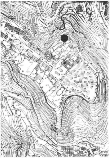
The Scallabis Roman temple was discovered as a result of preventative archaeological work that was carried out between the end of 1994 and 1996 in the Largo da Alcac,:ova 3-5 (Fig. 2), a site where a building whose date of construction we are not able to give, but which was already in existence in the middle of the XVII'h century, was to be refurbished; this refurbishment implied moving a great deal of soil in order to build a swimming pool.
At the time the area which was to be archaeologically surveyed was precisely that which would be covered by the above-mentioned swimming pool; however, a safeguard had been established that the works carried out in the building and annexes would always be accompanied by a team of archaeologists.
It was as a result of the archaeological survey at the works that, after the demolition of a garage and riding school on the site, it was possible to identify the podium of the Roman temple. In fact, these structures, which were built against the Western and Eastern facades of the temple, had hidden it completely. (Fig. 3)
The archaeological excavation was to prove that the space used as a garage was in fact founded on houses which, in recent times (XVIIl'h century) had rested on the podium of the temple. It is very possible that the cistern built on top of it dates from the same time, since the various water channels which fed it, and which we were able to uncover in the field work, were in keeping with the houses; this shows that the rain water caught by their roofs was led by the channels and fed directly into the cistern. The riding school had been built at the end of the XIX,h century, and for this a large part of the Eastern facade of the podium had been destroyed.
The Roman structure was, therefore, enveloped by other, much later constructions, and so it could only become visible after their demolition.
The walls situated to the East and North of the temple are usually dated from the Middle Ages, were subject to extensive restoration and various reconstructions during the XIX,h century, as can be seen by the date inscribed on one of the gates, 1880.
We should also add that the temple is situated on the north end of the Alcac,:ova plateau, in an area bordering the river Tagus and the Ribeira de Santarem, the place where we believe the port of Scallabis was established. The temple site visually dominates a vast area constituted by the river and its alluvial plain, and is completely visible from the possible port area.
This location must also be emphasised on account of the fact that it is very close to the traditional ways onto the plateau which, until the XIX'h century, were by the Calc,:ada de Santiago and its gate, and by the old Rua de Alpran. Both gave access to the most important Lusitanian roads, namely those which led to Merida and Bracara Augusta (Mantas, 1986: 16). We should also mention that the temple discussed here fits into an area of AJcac,:ova where, in the Middle Ages, and even today, there were important buildings: the Santa Maria da AJcac,:ova Church and the old royal Palace, the residence of D. Afonso Henriques, the first king of Portugal. Inside the church, archaeological surveys carried out in 1983 uncovered structures from the Roman period. Given the small area covered by the archaeological work, we do not yet have a clear understanding of the plan and functions of these structures. The
192 Ana Margarida Arruda & Calarina Viegas
type of masonry and the size are, however, sufficient to allow the possibility that they belong to a building of great importance. The columns which, even today, support the roof beams of the Church are crowned with Roman capitals from the Hnd and IHrd centuries A.D. (Femandes, 1997). There is a column capital from the IIIrd century, currently in the municipal Museum store, that comes from the old royal palace which was partially destroyed at some stage in order to make way for the palaces of illustrious figures.
Therefore, everything points to this area of the Alca~ova as the location where the public buildings of the Roman city were situated. Once again, we caU attention to the fact that this is, precisely, a site with close access to the plateau, which is located immediately on its left. It is true that the extensive areas excavated in different points of Alca~ova have revealed various Roman structures, but these are not as monumental as the structures found in the NE area of the plateau. Generally speaking, there are only walls, in a better or worse state of conservation, which were possibly parts of houses. No other place, however, has revealed architectural elements similar to those in this area, namely the above-mentioned capitals.
3.2. General description of the excavation work
The main objectives of the excavations in the area of the Roman temple were not only to uncover the structure of its podium but, above all, to obtain elements which would permit it to be dated. The detection of other possible structures in this area which would provide an urban framework for the religious structure was another of the objectives taken into consideration.
In order to fulfil these objectives a grid of 4 X 4m squares was defined; these were basically facing a North - South direction, and whilst the intention was that they should be adapted to the conditions under which the work was carried out, they were nevertheless used to establish stratigraphic sections perpendicular to the base of the podium in order to allow for the most correct reading of the stratigraphy possible.
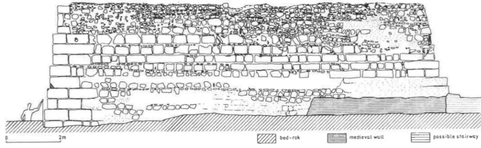
The excavation of the area surrounding the podium of the temple enabled an analysis of its structure and the detection of a series of other elements which are, in one way or another, related to it. Thus, records were made of Roman walls, some contemporary with the structure and now under analysis and others which clearly dated from an earlier period. It was also possible to see the remains of walls and floors associated with modern constructions. Storage pits from the Islamic period, oval in shape and carved into the bed--rock, were counted in great numbers (Fig. 10). It should be noted that in order to reach the calcareous bed rock it was necessary to dig through all the archaeological levels of the Roman and Iron Age periods which overlaid it, thus considerably disturbing the stratigraphy.
3.3. Description of the structure
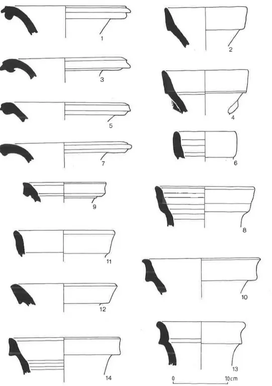
The podium of the Roman temple is the most important of the Roman constructions found to date in Alca90va de Santarem for which it was classified "Monumento Nacional". (Fig. 4-7)
Its best preserved facade (South) has a maximum height of 4.50m measured from the bed-rock; the West-facing facade is the same height. The Northern and Eastern facades are
The Roman temple of Scallabis (Santa rim. Portugal) 193
in a worse state of conservation, with heights of 4.20m and 1.90m respectively. The plan of the podium is roughly quadrangular, measuring 15.45m in an EastlWest direction and 15.25m North/South. These measurements correspond to 51 X 52 Roman feet. The podium was constructed on the bed-rock which was possibly shaped for this purpose; however, there is a Im difference in levels between the North and South facades. The narrow trench (10 cm), carved out of the rock and clearly marked on the South, West and North facades, which surrounds the whole base of the temple, must correspond to the prior marking of the land for the foundation of the ashlars, in other words, to the structure's construction trench. Its small size makes it unlikely that it was intended for draining water round the base of the temple, although this hypothesis should not be completely rejected. The corners of the podium were marked out with large ashlars of calcareous rock, laid width-wise.
The best preserved, South-facing facade still retained all its base constructed of ashlars. It is, in fact, in this same facade that part of the wall, rising from the base to the top of the podium, is still preserved; this wall defined the site of the temple itself, in other words the cella. This fact is proved by the existence of three ashlars on the SW corner of the building, which rise above the podium and which, including the nine which constitute it, make up a total of twelve on this corner. Of the worst preserved SE corner only five ashlars remain, all related to the podium.
It should also be noted that the whole base of the South facing-facade was constructed with well-hewn stones placed width-wise.
The West facade shows a total of 12 tiers of stones, but the fact that there is greater depth at its northernmost point obliged a further two tiers to be added in the NW corner. Here the corners also show the best hewn and largest ashlars, which is doubtless for reasons of structural stability. It should also be noted that the stones which constitute the West facade are smaller than those of the South and, at times, it is difficult to define their limits since they are partially covered with recent mortar: this was not removed in order not to weaken the structure.
The North facade is in a poor state of conservation, since the ashlars which constituted it have been removed almost down to the base. The strati graphic sections carried out here permitted us to ascertain that the theft of these stones very possibly occurred during the last century. In fact, the disturbance detected is clearly later than the remains of the modern houses, since it was carried out above the layers which were formed on top of these abandoned houses (Fig. 9).
The poor state of conservation of this facade did, however, enable us to examine the methods used for the construction of the podium, on account of the lack of ashlars which marked its limits. Thus, it is possible to state that it was constructed from the outside towards the centre, using medium size stones, placed in such a way as to create tiered, more or less concentric forms, joined by a mortar of lime and whitish sand, the typical opus caementicium. This solid construction was finally covered with ashlars on the south facade and medium-size stones with only one side hewn on the other facades. The four corners were also wholly built out of ashlars.
The East-facing facade suffered the greatest damage on account of the riding school which was built in the XIX'" century and has now been demolished. This construction, which was set between the passageway of the medieval wall and the temple, obliged part of the podium to be removed.
194 Ana Margarida Arruda & Calarina Viegas
It was also in the Eastern facade that we identified what we believe to be the base
of the stairway to the podium. It is an integral part of the podium but it does not occupy
the whole of this facade, its Northern upper part having been destroyed.
From the remains of this facade we have been able to establish that here, as on the Western and Southern facades, the tiers of stones which formed the base of this construction were of medium size, lightly hewn. Only the corners revealed good calcareous rock ashlars; three tiers of these ashlars remain on the NE corner and five, partially destroyed tiers
remain on the SE corner. It was also established that the structure which corresponded to
the Western wall of the riding school was a result of the destruction of a significant part of the podium's Eastern facade.
There were walls related to the temple on this Eastern side: they were perpendicular to the podium, but their significance cannot be properly evaluated. In fact, the excavation in this sector was conditioned by the circumstances in which the field work itself was carried out, the area freed up by the destruction of the riding school having been occupied with earth and debris from the building work which was being carried out at the same time as the archaeological excavations. In fact there are still many unanswered questions regarding the function of the series of walls under the structure of the podium's base; nevertheless, it is not unthinkable that these structures were destined to reinforce the base of the temple and that, given the proximity of the steep slope, they would have functioned
as buttresses to support the construction.
The top of the podium was destroyed in the central area by the cistern which dates from the XYIII'h century. Theft of stones was visible in all the remaining surface area; their imprints have, however, remained clearly marked. A series of brick water channels was also detected here. They led directly to the cistern to which they are connected, and must be associated with the modern houses which lent against the podium.
The excavation also led to another significant observation. A series of closely connected walls were identified surrounding the religious structure, grouped orthogonally. (Fig. 8). The field work allowed us to establish that these walls also date from the Roman period, belonging, however, to an earlier construction than that of the temple, since it can
be seen that the construction of the latter cut through them and largely destroyed them. In
this context it is also relevant that the temple has an orientation which is clearly distinct from the constructions which preceded it.
Given the destruction which they underwent, it is not possible to determine exactly
to what kind of structure they belonged. It was, however, possible to define a road, in the centre of which there was a water channel or gutter.
The information available on the Scallabis Roman temple can be summarised as follows:
1. its construction was founded on structures also dating from Roman times which it was to render useless and, in large part, to destroy;
2. its podium had a quadrangular plan and was solid, built of opus caemeitticium, covered, on the facades, with well-hewn ashlars or blocks which were simply carved; 3. the podium was 4.50m high;
4. all the corners were built with well-hewn ashlars;
5. on the Eastern side, the structure WqS buttressed at the base;
6. also on the Eastern side, there must have been a stairway on the side leading to the temple;
The Roman temple of Scallabis (Santarem, Portugal) 195
7. of the cella the only wall which remains is that which rises from the facade on the South of the podium, which makes it impossible to know if it was tripartite, bipartite or single;
8. at an imprecise moment in modern times, the podium's facades were used as the walls of houses which, leaning up against it, hid it (some of these buildings were still in use up until 1994, preventing it from being seen);
9. at this time, the construction of a c.istern implied the destruction of part of its central area;
10. the construction of a riding school in the XIX,h century completely destroyed the Eastern facade;
11. the theft of the stones from the top of the podium and of the ashlars from the Northern and Western facades as well as from the NW and NE corners also dates from the XIX,h century. These materials were used in the reconstruction of the medieval wall (1880) and also in the (re-)construction of the current Alca~ova
house.
3.4. Dating of construction and use according to
stratigraphic data
Archaeological excavation in areas which today are urbanised always raises problems of different sorts, especially in terms of the stratigraphic readings.
In this specific case, the problems were accentuated even more, inasmuch as this is a site where occupation in medieval, modem and contemporary times interfered directly not only with the structure which was built but also with the archaeological levels of the Roman period. The construction of the underground storage pits dating from Islamic times and dug into the calcareous bed-rock was particularly significant, as this caused great disturbance; the builders were obliged to cut through all the previous archaeological levels which, in this case, were Roman.
The theft of the podium's ashlars, not only of those above the ground but also of those which were buried, which took place in the XIX,h century, also implied the removal of earth next to the temple walls, in most cases down to the rock; this explains the modern ceramics which were found in the trenches opened during the last century. The opening of these trenches, which were difficult to fill, and their subsequent filling with debris, seriously damaged the stratigraphy, and this naturally adversely affected the dating of the building. Despite all these difficulties, it was possible to excavate levels which were relatively well preserved and which, based on the archaeological finds recovered there, allowed for more or less precise dating.
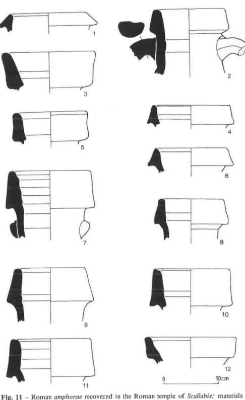
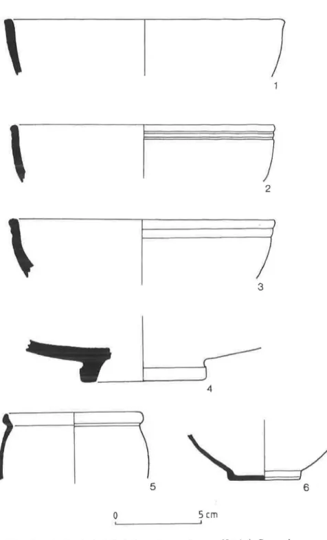
Thus, we can state that the group of buildings destroyed for the construction of the temple certainly dates from the Republican era. The finds recovered in the levels corresponding to the use of those buildings - Class 4 and 32 amphorae (Fig. 11 and 12) and Campanian ware, Morel, Especis 2320 (Fig. 13) - suggest a date from the middle of the I" century B.C., perhaps from the end of the second quarter; this also allows us to establish a post quem date for the construction of the temple.
196 Ana Margarida Arruda & Catarina Viegas
makes it difficult to ascertain the date when it was built. However, we found material from the middle of the I" century A.D. in levels next to the North facade which we can associate with its use; this material comprised lamps (Fig. 15) and South Gaulish sigillata (Fig. 14), which thus also provide an ante quem date for the construction.
We can therefore be certain that the Roman temple of Scallabis was built between the middle of the I"century B.C. and the middle of the I"century A.D., although this seems to be an excessively long chronology.
However, some elements gathered in other areas, particularly next to the NW corner,
permit a better definition of the chronological question. In some stratigraphic units the appearance of Italian-type terra sigil/ala associated with Class 15 and with the A variant of Class 16 amphorae was noted (Fig. 12); these point to a dating based on the end of the third and middle of the fourth quarter of the I" century B.C. However, there is no data which unequivocally guarantee that these levels are related, at least directly, to the construction of the monument, despite being earlier than those we consider to have been used.
At the base of a wall in front of the Eastern facade, which we associate with the temple since it is oriented in the same direction, we excavated preserved levels which provided materials which point to the same date, namely Italian-tYIJe sigillala (Consp. 10 and 13 forms) (Fig. 14) and also Class 16 amphorae.
A Class 15 amphora was found in the foundation trench, in a tiny area where there had been no subsequent disturbances. We know that this type of amphora has been classified as a typical product of Augustus' reign. However, this amphora appears, albeit in its "smalI" variant, in the Caesarean encampment of Lomba do Canho near Arganil, Portugal (Fabiao, 1989: 61-64) and also in Pompey's camp in Gran Atalaia de Renieblas near Numancia, in a context which dates from 74 9.C. (Koenen, 1929: 296-7).
This data permits us to advance the theory that the Scallabis Roman temple was constructed between the end of the Republican period and the beginning of the reign of Augustus, and was used as a place of worship during the whole of the Roman occupation; this seems to be proved by the appearance of later materials (African Red Slip wares, for example), although this comes from levels which have been disturbed.
4. THE ROMAN TEMPLE AT SANTAREM WITHIN THE FRAMEWORK
OF PROVINCIAL WESTERN ROMAN ARCHITECTURE FROM THE
END OF THE REPUBLIC AND THE BEGINNING OF THE EMPIRE
Religious architecture between the end of the Republic and the beginning of the Empire is very diverse, constituting a good indicator of the advance of Romanisation in the different areas of the Iberian Peninsular.However, it must not be forgotten that Santarem had long been incorporated into an urban civilisation with a special connection with the Mediterranean - this is documented, for example, by the set of Iron Age pottery discovered and by the square plan of the houses from the same period in the Alca~ova de Santarem.
According to Ward-Perkins (1970: p. 18), with Romanisation the majority of architectural types which are found in the provinces have Italian prototypes, but from different regions according to the areas with which they had greatest contact - on the one
The Roman temple of Scallabis (Santarem, Portugal) 197
hand Rome and Latium and on the other the region of Campania, Sicily and Magna Graecia, with a third area of influence from Transalpine Italy and the Italian Apennines. As we have already mentioned, there are innumerable aspects which complicate the establishment of exact parallels for the Scallabis Temple, such as its solid, square podium and especially the fact that the associated structures which integrate it into a larger architectural complex such as the forum are unknown. The only structure which is clearly associated with the podium is a wall running East-West, located 4.80m from its North-eastern corner. Also, the lack of architectural elements for the reconstruction of its principal facade makes it impossible to fit this structure into the wider framework of Western provincial architecture at the end of the Republic. We believe that this building could have had a single cella which might have occupied the whole of the podium's surface. Alternatively, it could have been split into different compartments - this is a difficult choice to make on account of the lack of incontestable architectural evidence. It is also not possible to solve the problem of access to the top of the podium, although the Eastern facade, near to the Southern side of the
podium, had what we believe to be the base of a built-in access stairway. This construction, only occupying part of the Eastern facade, does not appear at the Northern top level.
Square temples are, in fact, very archaic, and they would have constituted the inau-gural site of a city, following its cardinal points and directing the rituals of the auspicia
urbana. They would have favoured a commanding location looking out over the city (Gros,
1994). It is in the long evolution/maturation of this kind of construction that the so called
"Tuscan" temples, which follow the tradition and precepts established by Vitruvius in his
"De Architectura", should be situated.
There are two square religious buildings which we believe could constitute good parallels for the Scallabis Roman temple. These are pre-Augustan constructions with little in the way of preserved remains of wider architectural complexes, and they were, at a later date, incorporated in the Imperial fora. We refer to the so-called Temple B in Ordona (Italy) and the Sagunto temple (Spain) (Fig. 16)
Temple B in Ordona, which dates from an earlier period than the forum and Augustan basilica, in which it was to be integrated at a later date (Ward-Perkins, 1970, p. 7 and 8), has a square shape on top of an elevated podium which is reached by a stairway on the side. The building was stilI in the Etruscan-Italic tradition (Gros, 1994) and it constitutes the closest Italian parallel to the building in Santart!m, although it dates from a much earlier period.
Believed to have been built at a still unspecified time during the
nnd
century B.C.,the temple in the Sagunto forum is another building which is relevant to the Scallabis construction (Aranegui, 1991). Despite the poor state of conservation, it was possible to identify an almost square construction with interior compartments which were interpreted as belonging to a temple with a tripartite altar and pronaos, preceded by a cistern. This is a building whose size (11.90 x 14.28m) would be accordance with the tuscanicae
dispositiones in terms of a proportion of 5:6 (Aranegui, 1991). There is no epigraphic or iconographic data attributing the temple a specific divinity, but the author believes it to be a temple of the Capitoline cult. Study of the Republican building also showed that the construction module was maintained and served as a base for the overall architectural concept of the subsequent forum.
Religious buildings with square layouts, hollow podia and tripartite divisions also appear in Italy in places such as Cosa, Minturnae and Luni (Ruiz de Arbulo, 1991) (Fig.
198 Ana Margarida Arruda & Calarina Viegas
17). In Cos a, a colony established in the IIIrd century B.C., a series of transformations in 197 B.C. led to the construction of a triple Capitoline cella in the acropolis. In the colony established in the IIIrd century B.C. at Minturnae, which has marked military characteristics and covers an area of approximately 28 ha., there is also a triple cella temple on a podium. This is a temple to Jupiter, and the triple cella also proves its Capitoline character. It is located in an eccentric position in relation to the forum's square, which is defined by a portico with double naves on three of its sides (triple portico). The relation of this architectural complex in Minturnae to the urban fabric in which it is incorporated is not known. This is not the case with Luni, a colony dating from 177 B.C. whose forum is situated exactly at the junction of the main roads (cardus and decumanus maximus). This is yet another triple cella temple built on a podium, and everything points to it being Capitoline. The architectural arrangement which surrounds this structure, with one tri-portico with double naves, is a formula which was to serve as a model for innumerable other Republican fora in the oldest Western provinces.
Square designs are also present in numerous cellae of much later temples, but the overwhelming majority of them sit on rectangular podia. We also found several layouts with square configurations in a series of compartments which seem to be associated with basilicas. Dating from Augustan times, these buildings follow the provisions established by Vitruvius in the Fano basilica.
This could possibly be the case in Lusitania in the Augustan forum of Conimbriga, if Conges' (1987) re-interpretation of the origin and phasing of the development of the judicial complex is taken into consideration (Fig. 18). In fact, a square temple (11 x l2m) was found in the first plan of the civic and administrative centre of Conimbriga (Alarciio and Etienne, 1977); this was interpreted as having a cryptoporticus facade which simultaneously served to overcome the difference in levels in the land and to give this building a scenic setting. Since then, Conges has put forward a new proposal which aims to incorporate the area of the cry pto-portico into a basilica with a double nave with an axial aedes.
Likewise, the so-called forum of the lower city of Tarragona, has been the subject of a new interpretation in which, based on the remains found, the classic judicial layout of temple, square and basilica is not relevant (Mar and Ruiz de Arbulo, 1987) (Fig. 18). The recent analysis, which considered not only the archaeological remains present on the site but also the data provided by epigraphy and statues, sees a basilica with an ambulacrum on this site. In this case the exedra (13.07 x 11.20m) located on one of the longest sides of the basilica rises out of the body of this building by means of steps.
This kind of square compartment may either be situated at the top of the basilica, as is the case in Ruscino and Doclea, or on itn longest side, as is seen in the cases of Conimbriga and Tarragona and also in Fano, Ordona and Cosa. (Fig. 19)
In Fano, in the interior of the aedes Augusti, there are vestiges of a semi-circular wall which would have functioned as a court, and thus the political-administrative or judicial use and the religious function, as a sanctuary of the Imperial cult, were assimilated (Balty, 1990, p. 300) (Fig. 18).
Despite being square, these buildings do, however, raise a fundamental problem if they are to be linked with the building in Santarem, since they do not have a podium and are also incorporated in another construction, the basilica; this cannot be verified in our Lusitanian example on account of the lack of constructions clearly related to the temple.
The Roman temple of Scallabis (Santa rem, Portugal) 199
which we can compare with the construction at Scallabis, but these date from a much later period. We refer specifically to the "Sichelen II" temples of Augusta Raurica, Brigantium and Colonia in what is currently Germany, to Aventicum (Avenches, "Grange-des-Dlmes") in Switzerland and to Mazeroy and Champlieu in France, (Fig. 20).
Caesar's posthumous colony, Augusta Raurica, established in 44 B.C., was a strategic site of great importance to the Germanic limes up until the third quarter of the 1" century A.D. (Trunk, 1991). The "Sichelen II" temple in Augst, measuring 20.5 x 22m, has a
podium in a cryptoporticus built with irregular stones, which reaches a height of around
1.40m. It would have been possible to reach the top by two axial stairways situated on the Northern and Southern facades. On the top of the podium, the cella could be identified, forming a 7.15 x 8.80m compartment. All round this precinct there would have been a corridor, which has been variously interpreted by different researchers. Evidence for dating is scarce, but points to between the middle of the I" century and the middle of the IIlrd century A.D. The temple has been attributed to Diana (on account of the statues associated with it) and is situated outside the urban centre of Augusta Raurica, south of its forum, near to important access roads to the city.
The Brigantium temple also raises problems in establishing an absolute chronology, since it seems connected with early constructions on this site, probably from the time of Claudius or Flavius (Trunk, 1991). The archaeological finds from the temple area, however, show dates ranging from Agrippa to Constantius. This temple, where the gods of the woods were worshipped, is one of those with a tripartite cella on a square podium (9.2 x !Om) which fits into a temenos, albeit in an eccentric position. This precinct would also have been well located in relation to communicating roads, since a road approximately 6m wide was identified which is thought to be the cardus maximus.
The Colonia temple is also square with a tripartite cella (Capitoline) which is, likewise, integrated in a temenos. Once again, it is located outside the city walls, to the south, and is therefore isolated from the Roman urban centre.
In Grange-des-Dlmes, Avenches, a square construction was identified (Verzar, 1977) and, initially it was suggested that it originated in the "Celtic tradition". Archaeological work carried out in the 60's led to advances in reconstruction so that a typically Roman layout is presented, with four columns standing in front of the main facade, a cella and an axial stairway, with many classical decorative elements.' Amongst these, a group of fragments of clipei or medallions with images of Jupiter stand out: this permits it to be identified as a temple of the Imperial cult. In relation to its urban context, the building is some distance from the forum, near one of the city's main roads. The dating suggested considers not only the historical data known about this site but also the group of decorative elements whose suggested dates, based essentially on stylistic criteria, belong to the Hod
-IIIrd century. According to P. Gros, this example could solve the apparent paradox which surrounds the temples of the so-called "Celtic tradition", which in fact reach their high point during the Empire at a time when there were greater riches for the Western provinces and integration into the Imperial cult (Gros, 1994: p. 201).
We found another report, although brief and unillustrated, on an almost square (24 x 22m) temple podium at the Mazeroy site (Gallia, 1972: p. 358-560). Later, we discovered that this building had a square cella (l1.8m wide), since the remains of a wall which would have constituted the space between the building and the walls which surrounded it were identified. The scanty evidence for dating points to construction in the time of Tiberius or Claudius.
200
Ana Margarida Arruda & Catarina ViegasAnother French example of the square temple (22.30m wide) is to be found at Champ lieu (Grenier, 958: p. 409); in this case it is also a single cella temple with columns inlaid into the facades and with an axial stairway. It is part of a sacred precinct of perfect classical proportions with a relationship of 4 to 3; however, its connection with the surrounding urban environment is unknown.
New data on the different urban components in Santarem may only found by pursuing the research. The location of the temple, next to the slope which faces the current settlement of Ribeira de Santarem, gives it a position of great scenic value and enables it to be near to the important axes for access to the old urban centre. As we have seen, a similar position was chosen for a series of square buildings which, although they are dated later than the example in Santarem, should be taken into consideration. This theory also leads us to the possibility that the Scallabis temple was not integrated in a traditional judicial structure; instead, this might have been situated in another area of Alca~ova. On the other hand, if we concentrate on the examples provided by the Capitoline temples with tripartite cellae dating from the Republican period, these are part of sacred precincts which mostly developed into forum-basilica complexes. Unfortunately, the remains now revealed are still insufficient to reach any other conclusion.
5. DISCUSSION
The data we have presented leads to a discussion of certain questions and the formulation of a set of theories which seem to us to be pertinent.
Firstly, we believe that this discovery, along with others, definitively lays to rest the problem of where the Roman colony of Scallabis, known today as Alca~ova de Santarem, was located on the plateau. Today, there are no doubts that this colony was established on top of a military encampment, a fact which could, in truth, always be seen in the designation found in Pliny (IV, 117) and in the epigraphy associated with Santarem (Mantas, 1993). The chronology provided by the materials found in the levels underlying the podium is compatible with a military encampment during Caesar's praetorship in Ulterior. In fact the amphorae and lamps and the Campanian ware can be fitted into the late Republican period, and it is possible to date them at 61160 B.C.
There is insufficient proof for a definite date for the construction of the temple. However, everything points to its being built between Caesar's departure from the Iberian Peninsular in 48 B.C. and the beginning of Augustus' reign, specifically 27/25 B.C. As we have already mentioned in section 3.4, the finds which we were able to link, perhaps a little audaciously, with the construction period allow us to be fairly certain about this. The construction took place at an unknown time during those 21 years, although there were some material indications that force us towards the later date.
Thus, the construction of the temple may have coincided with the settlement of the veterans from Octavius' legions in Santarem, a fact which is documented, as discussed in section 2.3, by the enrolment of some of its citizens in the Galeria tribe. The chronological data which the materials provide leads us to believe that this deductio benefited the soldiers employed by Octavian in the Asturo-Cantabrian wars. The headquarters of the Conventus must have been established in Scallabis at this same time, which may also explain the construction of the temple. However, there is no sign that this building was associated with
The Roman temple of Scallabis (Santarem, Portugal)
201
any other basilica, although, as mentioned in section 4, on other sites square temples are almost always related to this kind of structure. The observations made by Mar and Ruiz de Arbulo (1987) in relation to the function of the compartments associated with basilicas are pertinent in this context. In this light we are faced with dual-purpose commercial and
judicial spaces, and the court would have been located in an aedes called the aedes augusti,
as mentioned by Vitruvius. This assimilation would have been one of the signs of the growing domination of the Imperial cult in relation to the main events of urban life, as in the specific case of Tarragona (Idem, p. 24).
The chronology attributed to the construction of the Scallabis temple doesn't allow us to consider that it was destined for the imperial cult, despite its location and the area it covers, on a vantage point overlooking a river frequently subject to great floods. There is a strong probability that, similar to what happens to many other square angled
temples, the Scallabis temple was a eapitolium. However, we are obliged to leave this
question unanswered, given the total lack of any epigraphic and iconographic data which might elucidate the matter.
BIBLIOGRAPHY
ALARCAO, J. DE e ETIENNE, R. (1977) - Fouilles de Conimbriga /, Paris: Diff. E. de
Boccard.
Ai..ARcAo, J. (1987) - Trar;os Essenciais da Geografia Polftica e Econ6mica do Vale do
Tejo na Epoca Romana, in Arqueologia no Vale do Tejo, Lisboa: IPPC, p. 55-58.
ARANEGUI GASCO, C. (1991) - Un Templu republicano en el Centro c1vico Sanguntino,
in Templos Romanos de Hispania, Cuadernos de Arquiteetura Romana, Vo!. I, pp.
67-82.
ARRUDA, A. M. (1993a) - A ocupar;iio da Idade do Ferro da Alca90va de Santarem no
contexto da expansiio fenicia para a fachada atHintica peninsular. In Estudos
Orien-tais (Aetas do Encontro "Os fenfcios no territ6rio portugues"). Lisboa: Instituto
Oriental da Universidade Nova de Lisboa, 4, p. 193-214.
ARRUDA, A. M. (1993b) -
°
comercio fenfcio. In Medina, 1. (Dir.) & Gon9alves (org.).Vo!. 2, p. 17-34.
ARRUDA, A. M. (1994) - A Peninsula de Lisboa entre 0 Norte atHintico e 0 Oriente
mediterranico. In Lisboa subterrllnea. Lisboa: Lisboa Capital Europeia da Cultura
94, p. 52-57.
ARRUDA, A. e ALMEIDA, R. R. (1998) - As anforas da Classe 32 da Alcar;ova de
Santarem. In Confmbriga. Coimbra: Instituto de Arqueologia da Faculdade de letras
de Coimbra, 37, p. 201-231.
ARRUDA, A. e ALMEIDA, R. R. (in press) - Importar;oes de vinho italico para 0
terri-t6rio portugues: contextos, cronologias e significado. In Aetas da fIle Table ronde
sur la Lusitanie romaine, Madrid, Casa de Velazquez I e 2 de Dezembro 1997.
BALTY, J. CH. (1993) - Le Centre Civique des Villes romaines et ses Espaces Politiques
et Administratifs, in X/Ve Congres d'Arqueologia Classiea. Tarragona, pp. 91- \07.
BALTY,1. CH. (1990) - Curia Ordinis, Reeherehes d'Arehiteeture et d'Urbanisme Antiques
sur les Curies Provinciales du Monde Romain, Bruxelles: Acad. Royale de Belgique.
202
Ana Margarida Arruda & Catarina ViegasRome Memoirs XXVI.
CONGES, A. R. (1987) - L'hypothese d'une basilique
a
deux nefsa
Conimbriga et lestransformations du forum, in Melanges de L'Ecole Franraise de Rome, T. 99-2, pp.
711-751
DOPICO CAfNZOS. M. D. (1988) - La tabula Lougeiorum. Estudios sobre la implantaci6n
roman a en Hispania. Veleia. VitorialGasteiz: Universidade de Santigo de Compostelal
IUniversidad del Pais Vasco, Anejo nO 5.
ETTLINGER, E. et alii. (1990) - Conspectus formarum Terrae sigillatae italico modo
confectae. Bonn.
FABIAO, C. (1989) - Sobre as anforas do acampamento romano da Lomba do Canho
(Arganil). Cadernos da UNIARQ. Lisboa: UNIARQ, Instituto Nacional de Investiga-~iio Cientifica. 1.
FERNANDES, L. (1997) - Capiteis romanos da Lusitania Ocidental, disserta~iio final de
Mestrado em Hist6ria de Arte apresentada
a
Faculdade de Ciencias Sociais eHuma-nas da Universidade Nova de Lisboa, Lisboa, policopiado.
GALLlA 30 (1972) - p. 358-360.
GARCIA BELLIDO, A. (1958) - Las colonias Romanas de la Provincia Lusitana, in
Arqueologia e Hist6ria, 8" serie, 8, pp. 13-23.
GARLSTERER-KROL, B. (1975) - Zu der Spanischen Stadtelisten der Plinius, in Archivo
Espanol de Arqueologia, 42, CSIC, Madrid, 1975, p. 117-128.
GRENIER. A. (1958) - Manuel d'Architecture Gallo-Romaine, Vo!. III. I, L'Architecture,
Paris.
GROS, P. (1994) - L'Architecture romaine du debut du /lie siecle av.
J.-c.
a
la fin duHaut Empire, 1: Les monuments publics, Paris: Picard.
HAYES, J. W. (1985) - Sigillate orientali, in Atlante H. Enciclopedia dell'Arte Antica,
Atlante delle forme ceramiche H. ceramica fina romana nel Bacino del Mediterraneo.
(Tardo elenismo e Primo Impero), Roma, pp. 1-96.
HAUSCHILD, T. (1989-1990) - Arquitectura religiosa roman a em Portugal, in Anas.
2-3, Merida, pp. 57-76.
KOENEN, C. (1929) - Die Keramik aus den Lagern des Scipio und den Lagern bei
Renieblas, in A. Schulten. Numantia IV, Munique.
LAMBOGLIA. N. (1952) - Per una classificazione preliminare della ceramica campana,
Atti dell I Congresso Internazionale di Studi Liguri, Bardighera, pp. 139-206.
MANTAS, V. (1986) - Arqueologia urbana e fotografia aerea: contributo para 0 estudo do
urbanismo anti go de Santarem, Evora e Faro. Trabalhos de Arqueologia (Actas do
I Encontro Nacional de Arqueologia Urbana - Setubal 1985). Lisboa, Instituto Por-tugues do Patrim6nio Cultural, 3. p. 13-26.
MANTAS, V. (1993) - As funda~oes coloniais no territ6rio portugues nos finais da
repu-blica e infcios do imperio. In Aetas do 11 Congresso Peninsular de Histaria Antiga.
Coimbra: Faculdade de Letras de Coimbra, p. 467-500.
MANTAS, V. (1994) - A rede viaria do territ6rio portugues. In Medina (dir.) & Gonyalves
(org.). Vo!. 2, p. 213-230.
MA YET, F. (1975) - La Ceramique
a
Parois Fines de la Peninsule Iberique, Paris:Diffusion de Boccard.
MEDINA, J. (dir.) & GONC;ALVES (arg.) - Hist6ria de Portugal. Lisboa: Edic\ube.
The Roman temple of Scallabis (Santa rem. Portugal) 203
interpretaci6n del llamado Foro Bajo de Terragona, in Los Foros Romanos de la Provincias Occidentales, Madrid, pp. 31-44.
MOREL, I.-P. (1981) - Ceramiques Campaniennes. Les formes. Paris: Ecole Fran9aise de Rome.
PEACOCK D. P. S. & WILLIAMS, D. F., (1986) - Amphorae and the Roman Economy, An Introdutory Guide, London, Longman.
PUCCI, G. (1985) - Terra Sigillata Italica, in Atlante ll. Enciclopedia dell'arte Antica, Atlante delle forme Ceramiche
n.
Ceramic a fina romana nel Bacino Mediterraneo (tardo elenismo e primo impero) Roma, pp. 365-406.RICCI, A. (1985) - Ceramica a Pareti Sotille in Atlante If. Enciclopedia dell' arte Antica, Atlante delle forme Ceramiche
n.
Ceramica fina romana nel Bacino Mediterraneo (tardo elenismo e primo impero) Roma, pp. 233-357.RUIZ DE ARBULO, I., El Templo del Foro de Ampurias y la Evoluci6n de los Foros Republicanos, in Templos Romanos de Hispania, Cuadernos de Arquitectura Roma-na, Vol. 1, 1991, pp. 11-37.
TRUNK, M. (1991) - Romische Tempel in den Rhein- und westlichen Donauprovinzen: Ein Beitrag zur architekturgeschichtlichen Einnordnung romischer Sakralbuten in Augst, in Forchungen in Augst, 14, Augst.
VERZAR, M. (1977) - Aventicum 11. Un temple du Culte Imperial. Cahier d'Archaeologie Romande, 12, Avenches.
WARD-PERKINS, I. B. (1970) - From Republic to Empire: Reflections on the Early Provincial Architecture of the Roman West, in Journal of Roman Studies, LX, pp. 1-19.
204 Ana Margarida Arruda & Calarina Viegas
.
,
.
.
•
.
" .
lJ'
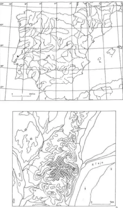
Fig. 1 - N° 1: The position of Santarem in the Iberian Peninsula; n° 2: The Alca~ova of Santarem and its relationship with the Tagus river.
Tile Roman temple of Scallabis (San/arim, Portugal) 205
~Roman ~ Medieval ~J[$.i Modern/(ontemporony
"'
'"
..,
.,
s:
'"
'"
.;:;:'"
a
~ -§ ::s...
...
...: ~...
'"
to
~
/1///
~
'"
s:: ...:'\'
~
~m 'ClThe Roman temple of Scallabis (Santarbn. Portugal) 207
E
.,
~
<3 r;: .t: <38
o<J1
...::.g
.;:: <3 ~~
<3 r;: ...:: 00 ~,-
_
__
_
____
1
m ~ bed-roll;=
medieval wall ~ possible stairway210 Ana Margarida Arruda & Calarina Viegas ~ ciQ-....;j I ~ ('0 ~ ~ -0