2018
Urban requalification in the Suburbs – development of a
strategic axis in Agualva-Cacém
Inês Lopes Pereira Abreu
Dissertação para obtenção do grau de Mestre em
Arquitetura Paisagista
Orientadora: Selma Beatriz de Almeida Nunes da Pena Baldaia
Júri:
Presidente: Doutora Maria Teresa Gomes Afonso do Paço, Professora Auxiliar do Instituto Superior de Agronomia da Universidade de Lisboa
Vogais: Doutora Selma Beatriz de Almeida Nunes da Pena Baldaia, Assistente Convidada do Instituto Superior de Agronomia da Universidade de Lisboa
Doutora Maria Cabral Matos Silva, Bolseira Pós-doutoramento do Centro de Investigação de Arquitectura, Urbanismo e Design da Faculdade de Arquitectura da Universidade de Lisboa
1 Agradecimentos
Dedico este trabalho aos meus pais, pela contribuição directa para a minha educação, ao meu irmão Rúben, avós, avôs e família próxima pela amizade ao longo dos anos.
Um obrigada à minha orientadora Selma Pena, pelos conhecimentos e disponibilidade. A colegas e professores do ISA que directa ou indirectamente contribuíram para este trabalho, que me acompanharam ao longo dos anos, e que me motivaram ao pensamento crítico. A todos os arquitectos paisagistas que tenho conhecido até agora e que me inspiram pela criatividade, resiliência e qualidade de trabalho.
2 Abstract
Urban centres and cities are par excellence representations of complexity of human landscapes and environments. In the context of a rapid urban growth and a technologic centred world, these places are the stage for dynamic changes, and reveal a heterogenic spatial, human and ecologic composition in both hemispheres of the World.
Having this complex space in mind, the present dissertation intended to frame the field of action of landscape architecture in a specific type of urban settlement - the suburban one, in a way of establishing good quality public spaces while combining social/cultural and ecological concerns. The case study was the “satellite” city of Agualva-Cacém, located between Lisbon and Sintra - an important Portuguese city for its cultural landmarks and ecological context.
In this sense, an analysis of the concept of “quality” in the outdoor space was made, as well as a reflection upon good design practices for public parks and urban streets. Secondly, design strategies in the case of Agualva-Cacém were proposed, considering environmental and social concerns: in one hand, to contribute to a more sustainable management of water, soil and to contribute to the green infrastructure of Agualva-Cacém; in another hand, to change the image of the city and improve the quality of life within a contemporary urban environment characterized by spatial fragmentation, dependency on the use of the automobile and daily pendular movements of people. This was achieved through the proposal of requalification of urban spaces confined in a delimitated strategic axis, composed by an avenue and two different public parks.
The three public spaces of this axis are then interconnected, forming a continuous system of water circulation, green continuity, soft mobility and public spaces.
Keywords
3 Resumo (Português)
Os centros urbanos e as cidades são, por excelência, representativos da complexidade das paisagens e ambientes humanos. Num contexto de rápido crescimento urbano e de um mundo centrado na tecnologia, estes lugares são o palco de mudanças dinâmicas, e revelam uma composição espacial, humana e ecológica heterogénea em ambos os hemisférios do mundo.
A presente dissertação pretende enquadrar o campo de actuação da Arquitectura Paisagista num tipo específico de aglomerado urbano - o suburbano, de modo a estabelecer espaços públicos de boa qualidade, combinando em simultâneo preocupações sociais / culturais e ecológicas. O caso de estudo apresentado trata-se da cidade "satélite" de Agualva-Cacém, situada entre Lisboa, a capital de Portugal, e Sintra - uma importante cidade portuguesa pelo seu património arquitectónico e contexto ecológico.
Neste sentido, apresenta-se em primeiro lugar um exercício de análise do conceito de "qualidade" no espaço ao ar livre, bem como de reflexão sobre boas práticas de design de parques públicos e ruas urbanas. Em segundo lugar, serão propostas estratégias de projecto no caso de Agualva-Cacém, enquanto tentativa de mudança da imagem da cidade e melhoramento da qualidade de vida num ambiente urbano contemporâneo, caracterizado pela fragmentação espacial, dependência do uso automóvel e movimentos pendulares diários de pessoas. Tal é levado a cabo através de uma proposta de requalificação de espaços urbanos confinados num eixo estratégico delimitado, composto por uma avenida e dois parques públicos.
Palavras-Chave
4 Resumo Alargado (Português)
Os principais objectivos desta dissertação são a abordagem do espaço público num contexto suburbano enquanto instrumento do âmbito da arquitectura paisagista para promover boa qualidade urbana e uma proposta de requalificação de três diferentes espaços. O caso de estudo trata-se de um aglomerado suburbano da área metropolitana de Lisboa – a cidade de Agualva-Cacém, escolhida para o efeito devido à representatividade de problemas urbanos contemporâneos: fragmentação espacial, uso excessivo do automóvel pessoal e movimentos pendulares diários de pessoas, apresentando em simultâneo um contexto social desafiante, problemas estes que se pretendem resolver através do planeamento e desenho de espaço público:
Na primeira parte da dissertação, serão apresentados conteúdos teóricos referentes, em primeiro lugar, ao conceito de suburbanização enquanto fenómeno específico de urbanização do território. De seguida, aborda-se o conceito de qualidade urbana e o seu significado no âmbito da arquitectura paisagista, ao conceito de espaço público enquanto instrumento de promoção de boa qualidade urbana, abordando-se em específico projectos de referência de redesenho de ruas urbanas e parques públicos.
De modo a materializar as ideias apresentadas, é feita na segunda parte da dissertação a análise do caso de estudo, considerando informação geográfica e propostas incluídas no Plano Verde do Concelho de Sintra, um projecto realizado em parceria entre ADISA/ISA (Centro de Estudos de Arquitectura Paisagista – Prof. Caldeira Cabral) e a Câmara Municipal de Sintra. O método de trabalho neste segmento da dissertação inicia-se com um processo de análise do território, à escala da cidade, considerando aspectos como a evolução da paisagem, estrutura ecológica, dados demográficos e serviços/equipamentos, seguida por uma análise à escala da área de intervenção. É abordada também, de um modo hipotético, a questão da participação pública e de como poderia ser incorporada no design destes espaços públicos. A proposta visa o redesenho do perfil da Avenida dos Bons Amigos, e a criação de dois novos parques urbanos com caraterísticas diferentes: Parque dos Quatro Caminhos, no qual o elemento da água assume uma especial importância e Parque Norte, parque recreativo e residencial. Estes três espaços encontram-se conectados, apresentando potencialidades e características negativas que serão abordadas nas estratégias de design Intenciona-se aqui promover uma continuidade espacial ao nível dos espaços verdes, da mobilidade suave, da gestão das águas pluviais e de áreas activas.
5 Index Index ... 5 List of Annexes ... 7 List of Figures ... 8 1 _ Introduction ...10
1.1. Human Intervention and the Dialogue of Nature/Culture ...10
2_Suburbanization ...13
2.1. Suburban territories throughout the times ...13
2.1.1. Industrialization ...13
2.1.2. Post-War until 21st Century ...15
2.1.3. 21st Century – Suburbs as the personification of the contemporary city ...16
3_(Sub) Urban Quality- between Functionality and Aesthetics ...19
3.1. (Sub) Urban Quality ...19
3.2. Quality in Landscape Architecture ...20
4_Public Spaces as an instrument to reach urban quality ...23
4.1. Public Spaces – Guidelines and Quality Assessment ...24
4.2. Green Spaces ...27
4.3. Unplanned Green Spaces – The “Third Landscape” ...28
4.4. Planned Green Spaces ...29
4.4.1 Parks ...29
4.4.2 Guidelines to design a park in the 21st Century ...31
4.4.3. Pocket Parks ...33
4.4.4. Urban Streets ...35
4.4.5 Reference Projects ...37
6
6_Case of Study ...43
6.1. Intervention Area – Location ...43
6.2. Methodology ...44
6.3. The Metropolitan Area of Lisbon (MAL) – Development and expansion ...45
6.4. History of the City and Territory Evolution ...47
6.5. City Scale Analysis ...49
6.5.1. Evolution of the Landscape ...49
6.5.2. The Sintra Municipal Green Plan (Plano Verde do Concelho de Sintra) ...50
6.5.4. Social Equipment...52
6.6. New environmental strategies of the municipality of Sintra ...53
7_Proposal ...54
7.1. Analysis and contextualization of the intervention area ...54
7.1.1. Urban Ecological Context - Integration of the axis in the SMGP ...55
7.1.2. Urban Ecological Context - Integration of the axis in the urban green network ....56
7.1.3. Integration in the Route System proposed by the Sintra Municipal Green Plan ...57
7.1.4. Cycling Network ...57
7.1.5. Pedestrian Pathways associated to waterlines ...58
7.2. Description of the Proposal ...60
7.2.1. Participation Method with the Communities ...60
7.2.2. Overall Concept and Goals ...61
7.2.3. Bons Amigos Avenue ...62
7.2.4. Quatro Caminhos Lake Park ...65
7.2.5. North Park ...69
Conclusion ...71
7 List of Annexes
I_Historical Map - 1940 II_Historical Map - 1989 III_Photo Inventory
IV_Public Participation_Example Map V_Building Use
VI_General Strategy
VII_Overall Strategy_System Diagrams VIII_Bons Amigos Avenue
IX_Quatro Caminhos Park_General Plan X_Quatro Caminhos Park_Strategies XI_North Park_General Plan
XII_North Park_Strategies XIII_Parks_System Diagrams
8 List of Figures
Figure 1 – Hierarchy of housing typologies in Manchester. Source: Benevolo, 1980. ... 14
Figure 2 – Model of the Ville Radieuse by Le Corbusier. Source: Archdaily, 2013.. ... 14
Figure 3 – Graphic with criteria for public space assessment. Source: PPS, 2009.. ... 25
Figure 4 – Map showing the interconnected green areas part of the Emerald Necklace in Boston. Source: Emerald Necklace Conservancy.. ... 30
Figure 5 – Example of an active area in Gleisdreick Park, by Atelier LOIDL. Source: Grosch, Petrow, 2016.. ... 32
Figure 6 – Graffiti as a space appropriation tool. Source: Grosch, Petrow, 2016.. ... 33
Figure 7 – One large and pedestrian-friendly entrance of the park. Source: Grosch, Petrow, 2016.. .. 33
Figure 8 – Proposal “Cut Outs” by Dyvik Kahlen. Source: Plan Común, et al, 2016.. ... 34
Figure 9 – Streetscape activities, adapted from Gehl, 2007. Source: Author… ... 35
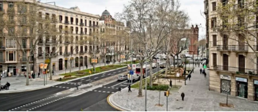
Figure 10 – Overview of the Passeig St Joan. Source: Landezine, 2012.. ... 37
Figure 11 – Soft mobility lane in Passeig De St Joan. Source: Author… ... 37
Figure 12– Sitting area and permeable pavement in Passeig De St Joan. Source: Author.. ... 37
Figure 13 – Areas with dense vegetation in Buffalo Niagara Medical Campus Street. Source: Scape Studio... 38
Figure 14 – Overview of the Buffalo Niagara Medical Campus Street. Source: Scape Studio.. ... 38
Figure 15 – Participation process with illustrative cards. Source: Planung Freiraum, 2016... ... 41
Figure 16 – Diversity of users in Nauener Platz, Berlin. Source: Planung Freiraum, 2016.. ... 41
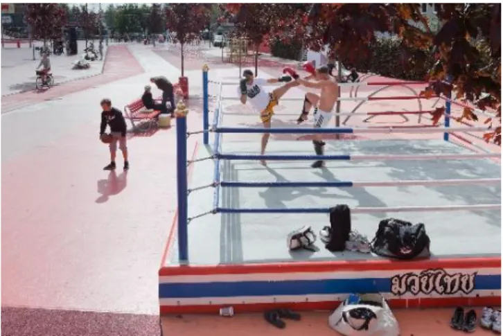
Figure 17 – A Thai ring box as one of the exotic elements of Superkilen Park. Source: Archdaily, 2012.. ... 42
Figure 18 – About 60 different nations were represented through different urban furniture elements along the Park. Source: Archdaily, 2012.. ... 42
Figure 19 – Location of Agualva-Cacém in the Metropolitan Area of Lisbon. Source: Author, 2016. .. 43
Figure 20 – Methodological phases. Source: Author, 2017.. ... 44
Figure 21 – Graphic showing the main urban growth axes of the AML. Source: Telles, 1987... ... 45
Figure 22 – Disperse urban growth left interstitial spaces in between cities. Source: Telles, 1987... .. 45
Figure 23 – Constellation of suburban cities between Lisbon and Sintra. Source: Author, 2017.. ... 46
Figure 24 – Rural character of Agualva-Cacém in the 1950’s. Source: Centro de Formação da Associação das Escolas de Sintra, 2017.. ... 48
Figure 25 – City skyline of Agualva-Cacém with Sintra in the background. Source: Author, 2016.. .... 48
Figure 26 – Diagrams showing the evolution of the landscape based on military cartography (1940, 1958, 2008). Source: Author, 2016.. ... 49
Figure 27 – Ecological Network of Agualva-Cacém based on geographic data of the SMGP. Source: Author, 2017.. ... 51
9
Figure 28 – Services and Social Equipment in Agualva-Cacém based on geographic data of the SMGP.
Source: Author, 2017.. ... 52
Figure 29 – Intervention Area based on Google Earth imagery. Source: Author, 2016.. ... 54
Figure 30 – Urban ecological network around the intervention area, based on geographic data of the SMGP. Source: Author, 2017.. ... 55
Figure 31 – Urban ecological network around the intervention area, based on geographic data of the SMGP, and graphic representation adapted from Dee, 2001. Source: Author, 2017.. ... 56
Figure 32 – Integration of the intervention area in the network of cultural and bicycle pathways, based on the proposal and geographic data of the SMGP. Source: Author, 2016.. ... 59
Figure 33 – Overall Intervention. Source: Author, 2017.. ... 61
Figure 34 – View upon the Bons Amigos Avenue. Source: Author, 2016.. ... 62
Figure 35 – Streetscape intervention in the Bons Amigos Avenue. Source: Author, 2017.. ... 63
Figure 36 – Close-up of the redesign of the avenue. Source: Author, 2017.. ... 64
Figure 37 – View upon the actual state of the site. Souce: Blog Rouxinol dos Pomares, 2016.. ... 65
Figure 38 – General plan of the Quatro Caminhos Park. Source: Author, 2017... 67
Figure 39 – Initial sketches for the Quatro Caminhos Park. Source: Author, 2017.. ... 68
Figure 40 – Representative image of the character of the North Park site. Source: Author, 2017.. ... 69
10 1.1. Human Intervention and the Dialogue of Nature/Culture
In order to provide an insight upon the role of Landscape Architecture in a suburban context, an initial introduction regarding the spatial duality of Nature-Culture will be made, in the light of the Anthropocene. It is an epoch pointed by Eugene Stoermer, characterized by an overwhelming influence of the human action on the Earth’s ecosystems, climate and geology (UNIVERSITY OF WISCONSIN – MILWAUKEE, 2014). The beginning of this epoch can be attributed to the advent of the industrial revolution, or after the Second World War, when radioactive substances were left over from atomic bombs. This concept has been actively discussed in recent years due to the human impact on climatic changes (SAMPLE, 2014).
In these terms, the concept of “deterritorialization” (GUATTARI, 2014), is characteristic of the “post-modern” society of the last fifty years, and expresses a concern on the direct impact of Man for the deterioration and fragmentation of the social and natural environment. The planet earth is now a stage of intense technical and scientific transformations that unbalance ecological phenomena, and trace a path of apparent uncontrollable and crescent deterioration.
When recognizing the spatial and environmental impacts of the human activities, the duality Nature-Culture duality can be considered, as it defines two main dimensions of the concept “space”- “natural space” and “cultural space”. In one hand “natural space” can be defined as the surrounding and physical space that was not changed by the human hand and exists independently from its activities. Despite its gradual alteration, “natural space” stands for the ground level where human activity takes place, and provides the “raw material”: the foundation layer, with a specific geologic and climatic character, which has its own dynamics and processes (LEFEBVRE, 1991). On the other hand, “cultural space” is the space that was altered by the human hand. Culture stands for human processes that have been developing – intellectuality, language and symbolism. Culture reveals itself spatially in the sense that space is a reflection of social individual and collective dynamics, politics that led to the formation of boundaries and enclosing territories through strict frontiers (LEFEBVRE, 1991).
11 In this sense, nowadays one can point that a prevalence of “Culture” over “Nature” can be noticed, and a progression from Nature to Culture seems to perpetuate, as societies have evolved over time and materialized their own social rules and meanings in the space, in a way that influences and overlaps the “natural space” (MCCORMARCK, 1980).
The actions upon space and the constant influence of human action towards the natural space are therefore in correlation with the birth of humanity and reflect the human condition in different levels – space progressed from being sacralised to being the ground of contemporary capitalist cities, as well as the different stages that took place in between (JELLICOE, JELLICOE, 1995).
The relation between Man and natural space became extremely close, and after space started to be used for agriculture and after the discovery of fire, the “natural space” became a means for survival and prosperity that could be controlled, and, most of all, space was now consequential and responsive to human inputs. This certainly influenced the fixation of human in the territory, and led to the development of new techniques that would allow to manipulate the rough natural forces, and fight the innate adversities of the site (JELLICOE, JELLICOE, 1995), in the same time that knowledge, political forces, technology and money accumulated over time (LEFEBVRE, 1991).
For this reason, cities are not isolated entities, they are landscapes, as they are integrated in the planet Earth’s intricate biologic and geologic systems, and reveal equally cultural complex networks (FOXLEY, VOGT, 2010). Cities are the paradigm of the manipulation of these natural processes, as they are complex bodies of human settlements, a spatialized result of successive events of migration and fixation, an organized solution to achieve a secure life through dynamics of production, exchange, consumption of goods, information, as well as movement of people. Urbanization implies the movement of people from rural settlements to bigger ones, which implies the intensification of the built-up area and a greater consumption of natural resources. This process has lately intensified in different cities in the world, leading to the discussion of the duality of nature/culture, as these resources may not follow the massive demographic worldwide growth. Construction and transformation of cities represent extreme changes locally and globally, therefore it is important to think about spatial practices that deal with rapid growing urban developments and protection of natural resources (BURDETT & SUDIKC, 2007).
12 Landscape architecture is therefore a practice to be referenced as “…Culture and Nature come together in Landscape Architecture, in the sense that this activity merges these two spheres to form a meaningful, functional, cogent relationship (EISINGER, in LIEDTKE, SOERENSEN, 2014: p. 67).
The concept of “landscape” can be here equated to the concept of “space”, given that landscape is a spatial entity that has been transformed into an increasingly dense, Nature-Culture amalgam, as its definition goes beyond the physical space where energy and matter circulate. Landscape can be defined as mesh of signs and marks which demonstrate an intention, and which encode cultural networks of individuals of the same or of different communities, in an individual and collective level within the territory (PROAP, 2011).
Landscape is nowadays a spatial entity which encodes more than environmental ecology and natural processes. As a mechanised world rises over time, the concept of “ecology” is broader, as environmental ecology should not be considered as an isolated concept and practice, but also “social ecology” and “mental ecology” and their connections (GUATTARI, 2014). These concepts are important to face a fragmented urbanised society which is constantly dealing with issues such as unemployment, neurosis and environmental decay. Social ecology aims to develop practices which regards people in their collective form – communities, families, workers, citizens, while mental ecology addresses the individual and his connection with his body, with time, and life/death mysteries, and integrating him in the surrounding space (GUATTARI, 2014).
Designing a landscape equals to constructing a narrative, to assembly networks and setting systematic relationships, and to prefer systematic and integrated solutions rather than formality (FOXLEY & VOGT, 2010). If the landscape is considered as a metabolic system, on which changes and discontinuities are powerful elements, then its image is a result of its functioning. The design of urban settlements and the work of landscape architects in a context of fragmentation, therefore, matters, as it will be further developed along this dissertation.
13 Suburbanization is, above all, one form of production of space: is a result of the process of urbanization, of growth and decline, expansion and stagnation (BLOCH & KEIL, 2013). A suburban city can be broadly defined as an urban settlement located in a peripheral location to a dominant urban centre, with which a strong connection of dependence is maintained. These settlements have a prevailing residential character and exhibit a distinctive culture or way of life as well as a community identity (MUMFORD, 1961).
The term “suburb” corresponds to distinct imageries of territories in different regions of the world, however the term broadly refers to residential satellite towns which resulted from industrial expansion, real estate speculation, and its image in the public opinion is often negative and based on stereotypes (FLANAGAN, 1990). It is relevant to notice that a large part of the world’s urbanization is in fact a result of this type of urban sprawl, and that the “suburban” population is in many cases larger than the “urban”, due to mostly lower housing prices and democratization of communication routes to the city centre (PHELPHS, 2015).
2.1. Suburban territories throughout the times
2.1.1. Industrialization
After the second half of the 18th century, the Industrial Revolution found its course, starting in England, leading to an intense phenomena of rural exodus. This phenomena happened due to the increase in population, to the longer average life expectancy, and to technological advances. All these factors led to a new lifestyle of high demand of services and goods, and therefore to a wide development of unprecedented abundance. The steam engine invention triggered the emergence of new factories in areas surrounding the city, which would be strategically located near waterways and coal deposits. Therefore, new urban settlements grew beyond the existing “nuclei” of the old city shaped during Middle Ages. This old urbanism form was characterised by narrow and puzzling streets, incompatible with the recent intense traffic, and dense housing system, unable to offer enough space and comfort for the new housing demand. These industrial cities became dense urbanized working-class centres, and a result of real estate speculation, without any regards for the comfort and health of the inhabitants. In order to earn greater profits, a hierarchy of houses would be created: buildings
14 with direct access to the street or with backyards would be charged a significant amount of money, whereas houses with almost no windows were the cheapest ones to rent (Figure 1). This rapid and economic-based unhuman urban sprawl soon became an easy model to be replicated in many European cities such as Manchester, Paris, Hamburg, London, presenting no concerns about the planning of meaningful public spaces (BENEVOLO, 1980).
Facing the deplorable urban health conditions of London by the end of the 19th century, Ebenezer Howard proposed the “Garden City” - a new model of town planning with affordable housing that would have a countryside aura, as the city would be planned with abundant green areas and to be self-sufficient, with agricultural areas, cultural, commercial places, schools and housing. These new utopian views defended the benefits of an urban life based on community rooting and environmental health, however the cities were thought to be built in a suburban layout, becoming static and enclosed systems by themselves. This type of urbanism laid the foundations of suburban settlements in the case of the United States of America. The “Garden City” planning model is considered by Jane Jacobs an erroneous solution, as problems such as population growth and real estate speculation in the city centre cannot be solved through the creation of disperse and separated towns, with no community life (JACOBS, 1965).
However, the most important contribution to form modern urban cities worldwide, was perhaps the one from the International Congress of Modern Architecture (CIAM), fixed in 1928. The Swiss architect Le Corbusier proposed the Radiant City model, on which the city would grow vertically: each block unit should have access to sunlight, green areas on the ground floor and each individual should be free in his private sphere (Figure 2). This model laid out a principle which defines most of the cities of our times - Le Corbusier defended an almost authoritarian way to build a city, on which the functions “traffic”, “work” and “residential” would be spatially separated in a rational way. The street as reflex of a community spirit decayed, and the private car became the most important element for mobility, which inevitably was one of the factors which contributed to an unrestrained urban sprawl (FISHMAN, 1982).
Figure 1 – Hierarchy of housing typologies in Manchester (BENEVOLO, 1980).
Figure 2 – Model of the Ville Radieuse (The Radiant City)
15 2.1.2. Post-War until 21st Century
The end of World War II and its political, social and technological dynamics created new suburban territories, as they became the main residence location among middle class people in the Western countries. The Post-War was marked by the rebuilt of economies, redevelopment and growth of cities beyond their central limits. In the western countries, political entities facilitated suburban sprawl through the construction of new transport infrastructures, such as highways and train lines that connected these new fast growing satellite cities. An affordable, apparently comfortable and highly dependent on the use of the automobile lifestyle was now established (FLANAGAN, 1990).
A different approach of suburbia emerged in the later years of the 20th century (MASOTTI, 1973): the suburban fringe went through a specialization process, in terms that these peripheral residential towns became more independent from the central areas, as well as more diverse from the socio-economic and cultural point of view. As relatively low housing prices and new mobility infrastructures contributed to the enlargement of the urban settlements, new blocks appeared, that included not only the residential function, but also the establishment of services, commerce and retail, offices buildings, shopping centres, etc.
SIEVERTS (2008) alludes to the concept of “Zwischenstadt”, translated as “city in between”, in an era of “post-suburbanization” (MASOTTI, 1973), marking the intermediate position that these territories assume in different scales. The author establishes the relation between sprawl, fragmentation and globalization, placing the suburbs in a dialog between the “global” and “local” scales. European cities are now situated in a global context, as the European Union is a wide spatial network of diverse urban environments and cultures. These global influences push the cities to be more homogeneous, to develop more intricate means of communication and to dynamically exchange information. The suburban city has a crescent level of complexity and differentiation. In this regard, this model of urban growth did not follow the traditional dense and centred urban patterns from the past (SIEVERTS, 2008).
16 2.1.3. 21st Century – Suburbs as the personification of the contemporary city
The consequences of suburban sprawl are noticeable today in the urban environment of European cities, having created monofunctional streets, uncomfortable public spaces for pedestrian activity and having lost of a sense of community. According to BURDETT & RODE (2007: p. 8), “Suburbanization led to the separation of city functions, fuelling urban sprawl before we came aware of the consequences on climate change and social alienation.” These territories became therefore an important part of contemporary urban formations in particular in the turn of the century, as new peripheral residential, commercial and industrial hubs appeared. In spite of the variety of definitions according to cultural, geographical and social spheres, there are common characteristics which are connected to the cultural idea of what suburbs are considered, and what are their consequences in the relationship between people and the city space. It is important, as designers, to understand singularities of these urban contexts (BURDETT & SUDIKC, 2007):
- Fragmentation: The suburban life experience is highly associated to the relation between travelling time and living space, as the suburbs provide an experience of fragmentation, dividing people’s time into working time, private time, and the time in between, used for transportation. The inhabitant of this space plans his daily schedule according to transportation time between dwellings, workplace, shopping centre, etc (LEFEBVRE, 1991). Due to uncontrolled growth of the urban landscape, this
fragmentation is associated with disarrangement and chaos, leading to the emergence of a group of spaces integrated in the urban fabric without any use (underused
fragments); to the development of large high-speed roads which transform the public realm into an artificial, impersonal, and unpleasant space to be used by pedestrians;
- Automobile dependence and hypermobility: automobiles are often pointed as the main disturbing factor of the public realm, conducting to the loss of a sense of community and public space comfort. Car traffic is however nothing but a representation of
incompetence and sometimes of corruption of the power structures of a city, as the urban space and automobile traffic are sometimes joined together, under the influence of valuable amounts of money (JACOBS, 1965). For this reason, new and numerous complex infrastructures are built, instead of investing in a functional and affordable network of public transports. In this context, François Ascher proposes the concept of “The Tunnel Effect”, as tunnels brought a new addiction of shortening time and space in the city scale in daily travels and changing the experience of inhabiting in the city. This
17 tunnel is also a metaphor for the increasing alienation, making daily travels an empty experience (ASCHER, 2010);
- High Density: The construction of a high density suburban city is associated to more profits for the constructor, per unit of space, which explains why many European suburban cities present this characteristic. Overcrowded and highly dense cities have negative social and psychological effects in the urban atmosphere: “…the close living together of individuals who have no sentimental and emotional ties fosters a spirit of competition, aggrandizement and mutual exploitation. Frequent close physical contact, coupled with great social distance accentuates the reserve of unattached individuals toward one another and gives rise to loneliness. The necessary frequent movement of great numbers of individuals in a congested habitat gives occasion to friction and irritation” (WIRTH, 1938: p. 14). This growth was mostly undertaken very fast and without tight regulation, leading to overcrowded cities and leaving little space for public spaces and green areas, which are important for a healthy urban atmosphere, as well as for creating meeting opportunities;
- Social heterogeneity: many suburban territories are inhabited by a mix of diverse people, from a cultural, financial and social point of view. In the particular case of the suburban constellation of Lisbon, this led to social segregation problems, enhanced by poorly formed municipal institutions, who reveal themselves being unable to handle these problems. The main social challenge is that when a city is so culturally diverse, there is a lack of common cultural values which is replaced by money as a
measurement factor. This caused, for example in the “banlieue” of Paris, social tensions, segregation and racism towards minority groups (TIMMS, 1975).
The suburban space has therefore become a heterogeneous space, without any precise physical boundaries. The spatial dynamics are mostly characterised by daily long distance mobility, dissolution of relationships of proximity, where scale and complexity have made the space difficult to perceive and to read. This lack of planning leads to the existence of numerous urban voids, places for real estate speculation. In fact, the construction of these satellite cities represent an antithesis to sustainability, as a dense city that grew organically through a careful plan consumes less land, which optimizes the cost of infrastructure, transport and public facilities (ALVES, 2016). Living in this dense and “planned” city has become however a luxury
18 space to live in most big European cities, even though it is noticed that once people have a little more money, they decide to buy more square meters, but away from the city centre .
The spatial fragmentation that characterizes these suburban territories can be mitigated in the scope of landscape architecture, through regeneration of these voids into significant public spaces, such as parks, and through the redesign of urban streets, offering new opportunities of the presence of “nature” within the city, as it will be further applied in a real scenario in this dissertation.
19 3.1. (Sub) Urban Quality
In a suburban complex system, earlier characterized as a spatially fragmented, densely urbanized, and with a lack of a sense of community cohesion, landscape architecture can be seen as a practice that can amend these problems through design, namely through “requalification” projects. It is, therefore, relevant to reflect upon the meaning of “quality” in two different aspects: first, in the city itself – questioning what makes a city “good”, secondly, regarding landscape architecture as a design practice which promotes quality in the urban space through public space design.
LYNCH (1981) describes a cluster of qualities which form a city as “good”:
- “Vitality”: how cities provide good environmental conditions for human life – an anthropocentric criteria that considers the access to clean water, food and air, as well as a system of disposal of waste, which provides an environment of health and safety. It also considers the concern about other species and living being which are ecologically and economically useful to man;
- “Fit”, in terms of form and capacity of spaces, and how equipment and infrastructures respond to the demands and quantity of people;
- “Access”: how reachable places are - access to activities, information, other people; - “Control”: how use, access, and management of spaces are controlled by the people
who reside there;
- “Efficiency”: how the city can balance between cost and maintenance;
- “Justice”: how environmental benefits and costs are distributed among the inhabitants, according to some principles such as equality, need, intrinsic worth, ability to pay, effort expended, potential contribution, or power.
In fact, the ultimate goal of city planning is to reach these values, and achieve meaningful and sustainable solutions, which balance human needs with environmental, geographic conditions and resources. However, as far as city planning over the years is concerned, the city can be considered as a laboratory, a result of trial and error, on which one can compare distinct strategies that have been pursued in different cities. The reasons that prevent cities/urban centres from being quality places are mostly economic and political, as costly and upscale
20 projects are executed without bringing benefits to cities, for example, shopping centers and monofunctional areas (JACOBS, 1965).
However, according to WALDHEIM (2013: p.13), new ways of thinking the cities have appeared over the last decade, in order to contribute to more environmentally and socially fair cities, as “…over the past decade, an adjectivally modified form of urbanism has emerged as the most robust and fully formed critique of urban design and planning’s failure to produce meaningful, socially just and environmentally healthful cities. The structural conditions necessitating an environmentally modified urbanism emerged precisely because at the moment when European models of urban density, centrality and legibility of urban form appear rather remote and when most of us live and work in environments more suburban than urban…”.
Considering this change of paradigm, the practice of Landscape Architecture aims for spatial, and ultimately urban quality along two different stages: “Planning” and “Design”, and the two connect in the sense that “viable design begins with purposeful study and analysis” (TREIB, 2011: p. 87), meaning that planning is followed by design. The first one overlays information and parameters that conduct to design, as well as managing resources: “…the planning process rarely requires the active form-making that is central do landscape architecture. Realms of analysis and overlays will establish the parameters for making a garden for a suburban backyard, but they will hardly provide the design…” (TREIB, 2011: p.87).
3.2. Quality in Landscape Architecture
Considering the complexity of the activity of the activity of Landscape Architecture, the concept of quality is subjective and multifaceted. One can mention the two following dualities:
- Environmental-aesthetic quality: in one hand, one can approach the concept as a quantifiable criteria - quality in terms of its utilitarian and functional value, and how durable it is; On the other hand, an aesthetic, subjective criteria, related to the composition, its significance, capability of producing amenity and establish a connection between people and the place. This means that promoting environmental relevance and good atmosphere through design is connected with the quality of a certain space (VROOM, 2006).
- Static-dynamic quality: Quality in landscape architecture can also connote the passing of time. In a static way, for much as there is a constant positive connection between the
21 place and people over time - a durable and familiar association, or in a dynamic way, when the space is only significant during a certain period of time (VROOM, 2006).
Perhaps the most primary and important distinction among the concept of quality in the practice of landscape architecture is the environmental-aesthetic duality. The first covers the natural environment where natural processes, cycles and phenomena take place. A verifiable quality can be considered: one that can be evaluated based on objective analysis and reality, the study of causes and effects. Quality can also be assessed based on existing criteria or generally accepted standards, on which Environmental Impact Statements are generally based (VROOM, 2006).
OLIN (1988: p. 24) points that a mere ethic of “problem solving”, which brings social benefits to some extent, is sometimes considered more important than the creation of human environments which have other significance, namely an artistic one. However, more subjective criteria should be considered, as the way space is designed influences feelings of comfort and acceptance (OLIN, 1988). Good quality also involves the connection and the search to achieve affinity with the public: a certain place reveals a good atmosphere, when it offers people a sense of belonging and affection, and if it appeals to familiar emotions (MURPHY, 2005).
Aesthetic quality is considered subjective, in terms that it depends on the culture, experience, perception and judgement of the observer, however there is something concrete about the atmosphere of a certain place, which leads to people to agree on its character. Atmosphere is a result of all built elements and their eventual transformation over time, and its mutability or stability can depend on the residents as much on the developers to maintain them (THIBAUD, 2014).
WEIDINGER (2015) emphasizes the importance of the concept of “atmosphere”, as the author recognizes that landscape architects have the knowledge to incorporate atmospheric qualities through space composition, that cause sensorial experiences (visual, olfactory, tactile, etc), and comfortable space for users. In this way, landscape architects are capable of establishing a connection between these unmeasurable parameters with form. For example, the design of pathways is in connection with revelation of different viewpoints along its way, motivate distinct paces of movement, influence our sense of curiosity and encourage encounters. According to LOIDL (2014: p. 164), “relationships, relationships...are the essence of quality” referring the importance of the relative spatial position of the elements. Gestaltung theories proposed in the beginning of the 20th Century in Germany can be useful resources on this matter, since they “…describe design principles and elements, that is, contrast, symmetry, wideness and
22 constriction, threshold and vistas, which can help the designer to control spatial compositions and achieve distinct atmospheric impacts” (WEIDINGER, 2014: p. 95).
Conclusively, and considering ideas of OLIN (1988), spatial quality can reveal itself through a landscape architecture project in two different fields: environmental and aesthetic In one hand, the place is designed for being experienced by people, in an atmospheric/aesthetic and measurable point of view (climate comfort); in the other hand, the project should also represent ecological benefits to the city, in terms of integration of the project to the characteristics of the territory and its ecological features.
23 Public spaces assume nowadays an important role in contemporary cities, be it in the historical centre or in the peripheral area. They are fundamental elements of expressing the cultural capacity of a place, to work as functional structures in the urban fabric, proposing new environmental systems, as well as providing a good atmosphere to be experienced by people (EL-KHOURY, 2005).
In a suburban environment where planning of public spaces was neglected over time, it is fundamental to understand how and where they can be incorporated in contemporary suburban cities, as well as to recognize proposals of public space that combine a “matrix with a high degree of flexibility, which makes it capable of accommodating all the different players, uses and appropriations” (PROAP, 2011: p.124). The design of urban open spaces in the light of landscape architecture is therefore complex, as it combines social structures with natural resources, such as water and soil (FOXLEY & VOGT, 2010).
In a collective scale, public spaces are relevant meeting points. As quoted by Gehl, “The changing character of the city life with its demands for good city space is a new expression of one of the most important functions of city culture: the meeting of people.” (GEHL, p. 9, 2007); in the other hand, public spaces are also revelant in the individual sphere, “public spaces are an extension of our own lives, an environment where (…) we simply live” (PROAP, 2011, p.121), addressing the common issue of lack of space in a context of a dense urban territory.
Suburban territories have commonly no spatial and cultural cohesion, since they are often neglected and kept away from the political agenda. This lack of care instigates a consequential inertia and lack of political participation of the inhabitants in the city issues. In fact, according to BELL (2001: p.71) “the consequences of a sprawl settlement are the loss of distinctiveness of the older rural landscape with their variety of materials, diverse sensuous surface and unity of pattern. Bland landscapes are also the result of negligence in planning, design and management, coupled with a demand for cheap, short term solutions. They are the most challenging to change, because it is hard to justify spending resources on place that are not obviously ugly and degraded”.
In a suburban environment, the main reasons that conducted to the lack of interest in incorporating good quality public spaces in the local/municipal political agenda, are (BELL, 2011):
24 - The intense use of the automobile for daily travels and small distance itineraries. This conducts to a lack on investment in creating well structured, comfortable and pleasant pedestrian paths;
- Cultural reasons associated to the absence of social practices in the outdoors (socialization, walking, sports activities, barbecues, etc.);
- General belief that these spaces will enhance problems such as criminality and vandalism.
Public space design can mitigate adverse environmental, functional and aesthetical aspects of unplanned urban fabric, industrial sites and road infrastructures, as these areas are often regarded as unpleasant. It must provide a spectrum of different atmospheres, which are welcoming, secure, functional, as well as connected to where people live, work or study. Urban landscapes of streets and green spaces must also be designed considering protection of soil and water protection, as well as enhancing healthy urban activities and urban vitality.
The project of a certain public space must also consider its morphological effects in the city; It is important to analyse its context and also characteritstics that can contribute to form an urban ensemble and to a more connected surrounding urban fabric. In the case of a requalification project, it must therefore be integrated into the pre-existing urban fabric and in a way that a dialogue between public space and the surrounding is promoted, through the urban design of the square, park or street (BRANDÃO, 2002).
Given the urban challenges that many suburban settlements face, a public space creation or requalification project assumes a particular importance in the urban quarter/neighbourhood scale, in a way to tackle problems of air, water and soil quality, of social and economic equity and criminality (DUARNY, 2003: p.86). ORFF (2016: p.197) mentions the flexibility and readability of this scale, as it is “…a defined zone from which we can scale up and down (streetscapes, sites)”. This is also referenced by BUSQUETS (2005: p.53).: “…work in the “intermediate scale” comes in very useful: this means that while we establish the project on the basis of its own scale and autonomy, we force ourselves to look up to its wider context and down in a refusal to validate our project…”.
4.1. Public Spaces – Guidelines and Quality Assessment
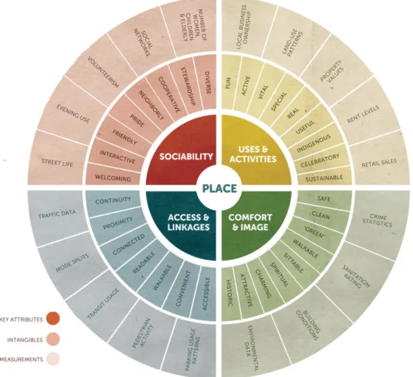
The non-profit organization PPS (“Project for Public Spaces”) dedicates to the education, planning and design of public spaces, as vector to build social cohesion. In order to provide an insight upon creating good quality public spaces, the organization proposed general
25 guidelines, represented in a diagram, which address to the complexity of “placemaking” and assessing how successful a place is- any public space can be a subject of evaluation.
According to the organization, successful public spaces seem to reunite the following cluster of four qualities: 1) good accessibility, 2) good atmosphere and comfortable, 3) uses and activities, 4) socially active. The “Place Diagram” (Figure 3) is organized in three levels: the first composed by these main criteria, the second level by subjective and qualitative aspects, and the third composed by quantifiable and measurable criteria.
26 This cluster of qualities can be questioned and described in the following way:
1) Access and Linkages – evaluates the accessibility of a place in relation to its surroundings, “…both visual and physical” (PPS, 2009). Accessible spaces are easily perceivable from a distance, easier and safer to walk by. They also present parking solutions, good traffic accesses, and interfaces with public transports.
Questions to consider while evaluating how accessible a public space is: Can you see the space from a distance? Is its interior visible from the outside? Is there a good connection between the space and the adjacent buildings and areas? Can people easily walk to the place?
Does the space function for people with special needs?
Can people use a variety of transportation options – bus train, car, bicycle, etc. – to reach the place?
2) Comfort and Image – assesses if the public space has a “good image“, if it offers a clean, safe and space to people, as well as the opportunity for people to site where they want.
Questions regarding Comfort and Image: Does the place make a good first impression? Are there more women than men?
Are there enough places to sit? Do people have is a choice of places to sit, in the sun or shade? Are spaces clean and free of litter?
Does the area feel safe? Is there a security presence?
Are people taking pictures? Are there many photo opportunities available? Do vehicles dominate pedestrian use of the space?
3) Uses and Activities - Is related to the leisure possibilities that a place offers, as it connects the people and the place. In the case, there are no possibilities for any activities, then the place will be empty.
Questions regarding Uses and Activities: Are people using the space or is it empty?
27 How many different types of activities are occurring – people walking, eating, playing baseball, chess, relaxing, reading?
Which parts of the space are used and which are not? Are there choices of things to do?
4) Sociability – Associated to the public space as a meeting point among friends, neighbours, but also the comfort level of interacting with strangers. This increases a sense of closeness with the community and to the public space.
Questions related to Sociability:
Is this a place where you would choose to meet your friends? Are people in groups? Are they talking with one another? Do people seem to know each other by face or by name?
Do people bring their friends and relatives to see the place or do they point to one of its features with pride?
Are people smiling? Do people make eye contact with each other? Do people use the place regularly and by choice?
Does a mix of ages and ethnic groups that generally reflect the community at large?
This diagnose method can be applied to every public spaces including the ones that will be described in the following pages: parks and urban streets, and later on developed in the practice through a requalification project.
4.2. Green Spaces
Green infrastructure planning is fundamental in a dense built-up urban environment, for its ecosystem services, namely water protection and carbon sequestration, as well as social benefits. Historically, this practise was remarkably addressed in the beginning of the 19th Century by the work of Frederick Law Olmsted and his collaborators, through the projects of Emerald Necklace and Back Bay Fens in the city of Boston, on which the landscape architect advocated that this practice should balance human environments and ecologic systems.
As the foundation rock for regarding landscape as an infrastructure was laid, it is essential to invest in site specific and multi-layered interventions that have positive impacts both in the
28 neighbourhood and that are regionally sustainable. To design landscape as an infrastructure in an urban environment means to seek a balance between optimal design and the dynamic character of cities, while avoiding inessential ornaments and formality, and enhancing urban functionality (HUNG, 2013).
Planning green infrastructure means to recognize areas with high ecologic value, and to establish a network of contiguous areas which provide ecosystem services, in order to maximise this value, and to interconnect to a maximum number of users (CZECHOWSKI et al, 2014). In a suburban context, this is relevant, in terms that it allows, in the common sense, the return of the nature to the city.
The contemporary suburban city presents two types of public green spaces, which will be further described (IPSEN, 2010):
- “Unplanned” green spaces – these are “leftover spaces”, with variable shapes such as islands, corridors, stripes, etc. This type of spaces are quite common in suburban cities, and are potential areas for green infrastructure planning, as well as open space design.
- “Planned” green spaces – areas that were associated to a city planning process. In this group are included large parks such as Tiergarten in Berlin, Central Park in New York, pocket parks and squares, wooded streets/avenues and private gardens.
4.3. Unplanned Green Spaces – The “Third Landscape”
The rapid growth of cities and built of communication routes originated many neglected and disconnected urban voids, within the boundaries and/or in the edge of the city. Georg Simmel established a divergence of meaning between the spatial entities of “edge” and “boundary”, - a boundary delineates a space, whereas edges are spaces which “lie between the inside and outside” and result from the rapid urban sprawl, as they resisted the market’s pressures of urban development, or of unused infrastructure (for instance, old railway lines) (IPSEN, 2010).
Gilles Clément categorizes these urban voids as the “third Landscape”. This term was based on the idea of “Third Estate” proposed by Abbé Sieyès, on which he defines that the “Third State” is everything, it has been “nothing” and it will be “something” (ROCCA, 2008: p. 40). The “third landscape” sites that are expecting a transformation, without any use mostly due to financial and political constraints. They are a “fragment of undecided garden” and a “subtraction of the anthropic territory”. (ROCCA, 2008: p. 40).
29 Some of the reasons that are appointed for the fact that these areas remain neglected are the lack of spatial structure, lack of security, inconvenience and disconnection from the urban surroundings, unprofitable land exploitation for urban development or agriculture. They are therefore left with no concrete use besides informal and public initiative vegetable gardens, illegal landfills, and occasional pasture fields. These forms of fallow land are located overall in the city, whether near industrial sites or residential areas, they are inactive places with no concrete planned social use, and are crossed by trampled paths (IPSEN, 2010).
In spite of this dormancy, the “third Landscape” represents highly dynamic and liveable places from the biodiversity point of view. Without alteration of the substrate, the place becomes quickly colonized by grass and later trees, not only by species of the native flora, but also exotic species capable of growing in such climates. This appropriation by nature is poetically seen by Gilles Clément as a sign of vitality and not of decay, and a sign of relinquishment of man towards land. Clément approach proposes the creation of a “mesh” of joining all these abandoned spaces, in a way to promote biologic continuity, and change our interpretation of the territory (ROCCA, 2008).
These unplanned green areas – either in the form of void in the middle of the urban fabric or as located in the city edge, are spaces of simultaneity, that fluctuate between persistence and transformation. They are areas to be potentially included in a green infrastructure plan of the city, promoting water and soil protection, as well as potential green public spaces that boost urban liveliness.
4.4. Planned Green Spaces 4.4.1 Parks
Parks can be broadly defined as permeable green areas with more or less dense vegetation, native and/or exotic species, designed for human leisure activities, natural resources and ecosystem protection. They represent the poetic of the presence of nature in an urban environment, as they promote environmental and social value to the city. Great urban parks in the British Islands, Bois de Vincennes in France and the public interconnected parks projected by Olmsted in North America (Figure 4), were pioneer projects in establishing green spaces in the urban context, for its ecological and social benefits, as well as influencing the real estate market by being an important element to incorporate in city planning (BECKER, 2010).
30 If in one hand, cities are developed places where social and cultural values are expressed, those are also the territories that lack most of the contact with the commonly called “nature”, and pushed away from its benefits in the physical and psychologic well-being of the inhabitants. Parks should be places that enhance both individual and community manifestations, offering opportunities for peace and quiet, as well as for meeting places (BECKER, 2010).
The planning and design of a park should not be, however, an enclosed action, as it should consider different urban dynamics of the site, and the interfaces of the park with its surroundings, regarding environmental and social aspects. It is relevant to approach parks not as isolated entities, but as places where the following dynamics are important:
- Parks as components of a green infrastructure: planning and design of parks should contribute to the Continuum naturale in the city scale. This enhances the ecossystem services of a park, in a way it seeks maximization of sustainable water management practices and soil protection, and enrichment of urban biodiversity (MAGALHÃES, 2001);
- Parks as promotors of neighbourhood and community unity: it is crucial to understand the interface park-neighbourhood, as geographical, urban, social contexts on which the park is located influence its functioning and maintenance. It is important to reflect upon the reasons that make a park survive, and those reasons are partly derived from the context – for instance the distinction between “vandalism” and “wear”, since the first one is an indicator of the lack of vitality and uses while the second addresses to an intense use (JACOBS, 1965).
Figure 4 – Map showing the interconnected green areas part of the Emerald Necklace in Boston. Source: Emerald Necklace Conservancy.
31 - Parks as ecologic dynamic systems: parks are biologically not enclosed systems, as they are permanently occupied by new botanical species. Clément alludes to the concept of botanical succession, as the system evolves through growth and destruction, and, phase by phase, reaches a state of equilibrium- “climax”- which can be defined as the set of botanical species which are adequate for a certain place. In these terms, it is primordial to recognise this botanical “movement” and recognize plants as dynamic components, which in the end compose dynamic systems (ROCCA, 2008).
Parks are, therefore, meaningful public spaces, whose planning and design involve site specific and complex decisions, in order to promote urban quality. Some contemporary park design principles that can potentially shape good quality environments will be presented next.
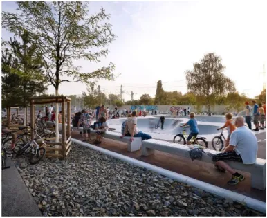
4.4.2 Guidelines to design a park in the 21st Century
The project of Park am Gleisdreieck by Atelier LOIDL in Berlin emerges as a reference project in the present-day, due to its thoughtful design which includes diversity of environments aimed to be used by different groups of users. The complex design process of the park is described through key topics, relevant in the context of a suburban city, characterized by its heterogeneity of users and presence of interstitial underused space (GROSCH & PETROW, 2016):
- The construction of a solid dialog with the citizens along the design process: given the examples of High Line Park in New York, Park am Gleisdreieck in Berlin and Park Fiction in Hamburg- the process of institution of these parks was in an initial phase, citizen-based and reclaimed from constructed development. It is essential to cultivate a strong sense of engagement and activeness, and a sense of belonging;
- The importance of incorporating complexity and heterogeneity on the design of the park: unexpected uses and equipment give a distinguishable character to the place, and cultivate aesthetic variety; Atmospheres are directly related to the design of the park, as diversity can be achieved through alternation between calm and active areas;
- Program intensively: offering numerous and well distributed places for retreat, encounter and activities. In addition, sitting places must not only be physically comfortable, but also socially, emphasizing that one must anticipate what the social and environmental consequences of the design are;
32 - Delimitation of hotspots of the park, as areas where many activities take place and where elements are related to one another (Figure 5); “A park should bring people together. It should give rise to a feeling of social closeness and a shared identity. Creating a relaxed atmosphere can contribute to mitigating social tensions or even prevent them from arising in the first place. It is necessary to encourage communication in a targeted manner, and produce a feeling of togetherness;
- Combination of different typologies of green areas: variety of vegetation typologies, associated to distinct maintenance intensities offers a variety of environments and sensory experiences. Vegetable gardens, for example, are also relevant for their social benefits;
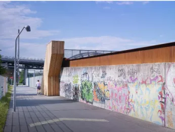
- Development of a narrative along the park: every area of the park adds history to the city. To incorporate street art, dynamic elements that appeal to aesthetic is to make the identity of a place more cohere. The park is, in first place, a public space, where should be used as an experiment field for citizens, therefore its design should make appropriation of a place possible. Allowing street art in some days, for example, is a form of symbolic appropriation that enriches the narrative of the city and the park (Figure 6);
- Design of appealing and barrier-free entrances, that promote a close connection to the surrounding urban fabric (Figure 7);
33 - Creation of a network of stakeholders who can maintain the park and participate actively on it: political actors, designers and users, through programmes of volunteering, membership. The successful design of a park doesn’t only include vegetation growth, quality materials, etc., but also its development of potentialities and collective creativity.
- Promoting security in the park: design the spaces and paths in a way they are easily noticeable. The design of meadows, and less shrubs, and social meeting areas, because the presence of many people and happenings build a lively aura of the park, which makes it be perceived as safe.
In the present-days, design of parks must address to a more heterogenic and culturally differentiated contemporary society, while offering a wide range of outdoor activities and recognizing people as active and participative members of the public space (GROSCH & PETROW, 2016).
4.4.3. Pocket Parks
Pocket parks are small-scale green areas, with a different range of sizes, including for example, the size of a building lot. This typology of green spaces is relevant in the situation of suburban cities, as many urban voids and underused spaces can be frequently identified among the urban fabric, that could potentially be transformed into small scale parks.
Figure 6 – Graffiti as a space appropriation tool. Source: Grosch, Petrow, 2016.
Figure 7 – One large and pedestrian-friendly entrance of the park. Source: Grosch, Petrow, 2016.
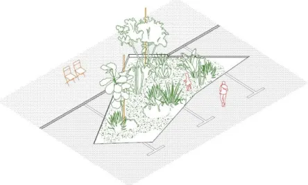
34 “Common places: urban playgrounds for Amadora” is a project that crosses pocket park design in a suburban context. The project was part of the Lisbon Trienale 2016, and coordinated by the architecture office Plan Común, and resulted from a collaboration with 12 other practitioners, whose main goal was to find solutions to design public open spaces in the suburban city of Amadora, Portugal. According to the participants, “Amadora lacks orientation, public space and active collective life” (PLAN COMÚN et al, 2016).
The outcome of this project were 12 proposals of “Urban Playgrounds”, no bigger than 100 m2. The main intention of the project was “…offering strategies for new places of encounter, which in their own specifitiy – order, form, format, and proportions – propose an antidote to the general lack of quality of contemporary public space shared by many cities throughout the world. They offer different kinds of use: from gardening to working, even focused on just wasting time. It is an opportunity to think about old / new human relations and the dimensions that allow them to happen” (PLAN COMÚN et al, 2016).
One of the proposals was “Cut Outs” by Dyvik Kahlen (Figure 8), on which it is recognized that most of the surfaces in the city are not permeable – asphalt and pavement dominate the streetscape and public spaces, despite the fact that Amadora is surrounded by open green edge areas. The designer stated: “Instead of adding even more building matter, we propose a principle of “cut outs” that are scattered throughout the city…”; “Those islands are created literally by cutting forms into the asphalt and pavement, and by a process of removing the existing material. We like to reveal the soil, give a potential ground for new plants, and introduce the surrounding wild nature into the city…”; “Their disruptive character should draw more attention to the existing material and textures and suggest potential pockets in-between buildings, streets, pavements, lampposts and furniture” (PLAN COMÚN et al, 2016).
35 4.4.4. Urban Streets
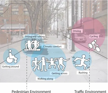
Urban streets are the vessels of the city, as when in an organized network, establish pedestrian flows of movement through the city. This urban network of streets is often hierarchized, and present a close connection between form and function, as large streets are frequently associated to a more intense traffic movement, and to the presence of numerous commerce and services establishments (ROBBINS, 2005). Streets are, therefore, places of coexistence and conflict among different users, and civic space that should provide a well-connected solution for pedestrian circulation .
Streets are lively places, where different dynamics of active and passive activities take place. Movement of cars, bicycles are the dynamic elements of the roads, whereas the pedestrian movement takes place in the sidewalk, where people socialize, meet by chance, go for a walk, sit and talk, among other activities (Figure 9). In a suburban context where the use of the automobile prevails, the conflict between pedestrian and car circulation is a constant problematic: “…traffic levels can have a severely inhibiting effect on public interaction at the street level. A fast, straight, trunk road can divide the community as effectively as a steel fence, in much the same way that suburban railway lines once often used to symbolically divide towns and villages into the “right” and “wrong” side of the tracks” (NEAL, 2003: p.187).
In this sense, requalification projects should rethink the general street layout, the public transport network, offer parking opportunities and promote the use of the ground floor, proposing solutions crossing the ecological context on which the street is located.
36 Sidewalks are the pedestrian fraction of the streets and an interface between the buildings and the street. The street is not only a vital part of urban centres and its circulation of people, as it is highly associated to the image that a person has from a certain city (NEAL, 2003). Streets are a mirror of the character and should be lively, climatic comfortable and pleasant public spaces to be experienced.
“A successful street and walkway pattern not only increases opportunities for people to meet, but also helps increase levels of trust locally through the frequency of face-to-face encounter and negotiation. A sense of trust – the belief that others, even strangers, are basically helpful and considerate – is essential to the social life of urban communities, and to local economic life as well (NEAL, 2003: p.189). Promoting “sidewalk contact” through design as by increasing this sense of trust, is fundamental for two reasons:
- Complex social problems often express in the form of crime and delinquency in the thoroughfare of suburbs, thus design has the capability of tackling these issues, by enhancing this “sense of trust” through promoting “sidewalk contact”- the disposition of different elements;
- In a multi-cultural environment inhabited by users of different origins, which is the case of the city described in this dissertation, the design of sidewalk can tackle issues such as segregation and discrimination, by promoting contact among varied groups of people (JACOBS, 1965).
Sidewalks are commonly perceived as mere places to access buildings, as car circulation is often prevailed, however sidewalk narrowness and inaccessibility conduct a more sedentary urban character. Large sidewalks offer more spatial opportunities for different infrastructures which are meant to serve different users, such as playgrounds, roller skating and cycling paths, benches. Ultimately, the well-use of the street attracts liveliness, security and sharing (JACOBS, p. 1965).