REGION
Israel Guarda1Maria Rosália Guerreiro2
AbstrAct
This study examines patterns of order and structure in street networks and its relationships with spatial life of two urban neighborhoods (housing estates). It explores the concepts of “tree” and “semi-lattice” as two different ways of looking and thinking about the structure of cities, each one generating a different form of life and community place (Alexander, 1965). The authors propose a configurational analysis of street networks of two urban plans designed according to different city ideologies and historical background. Based on space syntax methodology the street network was represented both as convex spaces and axial lines as nodes of a graph. The network was then analyzed in terms of the mathematical properties of the graph. The objective was to address a comparative study of structural properties of the urban street networks in order to speculate some implications on social life of each neighborhood. Syntactic measures have shown that conceptual designs have different spatial and social patterns both at global and local scales. It was corroborated that the difference between the characteristics of topological properties which reflects the mathematical principle of tree and semi-lattice is responsible for the different character of public life we found in each urban area.
Keywords: Space Configuration, Urban Plan, Space Syntax, Street Network, Urban Life. JEL Classification: N9, N94, C8.
1. INtrODUctION: sPAcE cONFIGUrAtION
Architects and urban researchers seem to be better equipped to measure and discuss forms and design programs rather than space itself. Just as forms are combined to create complex shapes, so can spaces connected to one another create spatial patterns. These topological relationships between spaces, also called configuration play an important role in the way we think about the environment. And influences the subsequent development of cognitive maps. In this way, the configuration of an urban space may contain important information to understand the degree of life of a given place. Spatial relationships influence movement and co-presence, which are strong indicators to envisage the social conditions and function of a space. Therefore, the value of studying spatial configuration as a complement of the study of the form cannot be overemphasized.
Descriptions of the city are shaped by the nearest available concepts and terms in common thought, and these are then turned into design and plans for new cities (Hillier, 2009: 1). The development of housing estates after the Second World War in the western countries
1 Israel Guarda, Instituto Universitário de Lisboa (ISCTE-IUL), CRIA, Lisbon, Portugal. ([email protected]) 2 Maria Rosália Guerreiro, Instituto Universitário de Lisboa (ISCTE-IUL), CRIA, Lisbon, Portugal. ([email protected])
which involved the construction of a large amount of affordable houses is a good example in the history of the modern movement in architecture. The construction of housing estates has been a large impact in the city as whole, however research on the subject is relatively recent and different perspectives have been explored: the tension between the new forms and the absent of spatial culture (Hillier, 1988; Hillier, 1996), the relation between the urban transformations and the history of design ideas (Hanson, 2000), the patterns of revolution in street and building typology (Marshall, 2005) and the consequences with segregation and social disadvantages (Vaughan et al., 2005; Legeby, 2010).
In Portugal, there are some studies that approached the production of housing estates (Pereira, 1999; Nunes, 2011). This studies focus the social and administrative processes, but give little attention to the impact of space configuration on the social life of the place. More recently that attempt was made in a comparative study of five housing estates built in Lisbon region between 1945 and 1974 (Guarda, 2016). This paper is a continuity of the research carried out in that study and focus particularly on how configurational theories and methods of space syntax can contribute to describe the spatial relations within different neighborhoods and in the city as whole.
This study examines patterns of order and structure in street networks and its relationships with spatial life in city neighborhoods (housing estates). The paper investigates the degree of life of two urban plans in Lisbon region, Areeiro (1946) and Portela (1965), having in account the degree of complexity of their spatial layouts. It explores the concepts of “tree” and “semi-lattice” as two different ways of looking and thinking about the structure of cities, each one generating a different form of life and community place (Alexander, 1965). Space Syntax will be the set of methods and techniques used for analyzing patterns of space - or space configuration – of the plans spatial layout. These methods both uncover spatial structures in cities and relate them to the way people move, stop and interact.
The paper is structured in seven sections. After the introduction, section 2 examines different patterns of order and structure in street networks as well as its implication on the life of a place. Section 3 describes the ability of space syntax to analyze this relationship between space and society and section 4 describes its tools and techniques necessary to carried out the configurational analysis of the case studies. Section 5 describes the syntactic measures to be evaluated. Section 6 analyses the historical background and the design program of the case studies and elaborates the configurational analyses globally and locally. Section 7 discusses the results of syntactic measures and concludes about the nature of the patterns of order and structure in the two urban systems which influence the social life of the place. Some difficulties and limitations of the method are also presented in the last section. 2. PAttErNs OF OrDEr AND strUctUrE IN strEEt NEtWOrKs: trEEs AND sEMI-LAttIcEs
The way that the street networks are connected influences the live of cities. Places that are more connected and more accessible increase the number of encounters and interaction between people while more segregated and less connected spaces tend to have less people and activities.
To understand the nature of these two kind of spaces and structures in cities, Cristopher Alexander publish in 1965, a seminal article called “A city is not a tree”. The objective of the article was to discover the abstract principle of ordering present in natural cities that makes them successfully alive and that the new modern concepts of town have not founded yet. The author just realized that the natural cities (traditional cities) have a semi-lattice structure while modern cities have a tree structure. In general, what Alexander argued was that natural
cities, (those created in a spontaneous manner over many years) maintain wealth, humanity and the variety of overlapping vital elements that worked in a complex way, (Figure 1, left). On the contrary, the modern city referred to the view that the elements of the city should be organized according to a strict hierarchy, according to which an element should always be contained in a larger element, and this in an element even broader, and so on (Figure 1, right and Figure 2). This tree view of the city reduces the possibility of combinations between the elements, reducing the possibilities of interaction and interrelationships in the city.
From the point of view of the experience of the cities, these two structures have profound implications. When a city has a tree structure, this rigidity and this discipline come into being in the city and its habitants. Examples of this tree structure are the neighborhood units of some garden cities designed to be self-sufficient and with few connections with other units, which would be connected only by major roads (Figure 2). In this type of structures, each end road relates only to the main road. Hence sets of buildings do not have any relation to each other. In some cases, they may be close geometrically, but topologically they are very far if we take into consideration the network of public spaces.
Figure 1 – trees (right) and semi-lattices (left)
Source: Alexander, 1967:24
Figure 2 – the urban street network as a tree. Maryland garden city, United states of America
This physical distance will have consequences on social distance. The tree structure order makes difficult to intercept the different units of the city. On the contrary, the units of natural cities overlap and have higher capacity of interception. The tree structure, according to Alexander, support only a small percentage of relations that occur in cities, since the possible combinations in such a strict hierarchy are smaller than in a structure with overlapping. 3. tHE sPAcE sYNtAX APPrOAcH
Space Syntax is a conceptual framework and a tool for analyzing patterns of space – or space configuration – in the built environment, which takes far more the Alexander’s view of the 1965. These methods both uncover spatial structures in cities and relate them to the way people move, stop and interact. Space plays an important role in the way we live in cities, having direct relations in our social life, offering preconditions for the patterns of movement, encounter or restriction (Hillier et al., 1984: x). In Space Syntax, spaces are understood as void defined by obstructions that might either constrain physical or visual access. The structural properties that comprise these spaces have an embedded social meaning that has implications on the overall behavior of human beings (Al_Sayed et al., 2014: 7). Different parts of the space are therefore associated with different behaviors and conventions, thus being possible to recognize specific symbolic and cultural values in the individual parts (Bafna, 2003: 17-18).
“Cities are aggregates of buildings held together by a network of spaces flowing in-between the blocks”
(Al_Sayed et al., 2014: 7). This network of spaces shapes spatial and social patterns which constitutes our experience of the place. This spatial network is the structure of the city. It has their own architecture formed by patterns of connections.
Space isn’t only a byproduct of buildings arrangement. Each space has at least one link to any other space. Therefore, it is also important to understand space as a network of interdependent spaces (configuration) and not just as individual parts. Space as configuration means “the simultaneously existing relations amongst the parts which make up the whole” (Hillier, 2005: 5). And the underlying principle is that spatial layout not only looks different but it is different seen from different parts off the spatial layout (Ibid: 6). Considering a building or a city, this means the number of steps which we must do from one space to all others. The differences can then be measured in terms of proximity, accessibility, discontinuity and separation. Observing these differences, we unlock patterns of space and see for example how much a space is integrated or shallow in a system – i.e. how close or far it is from every other spaces in a system. To reveal these patterns of space the spatial properties are measured and exposed by graph-based representations via Depthmap programme which is a software to perform spatial network analysis designed to understand social process within the built environment (Turner, 2011). The patterns of space might then be indicative of social organization.
4. tHE rEPrEsENtAtION OF UrbAN sPAcE: AXIAL AND cONVEX sPAcE The model of representation in space syntax is bi-dimensional. To process topological graph representations of space network in Depthmap software we have different techniques based on the definition of different spatial entities which have the capacity to produce different sorts of analysis on different scales. In this research we used axial and convex analysis as a powerful tool for predicting social and economic activity. Each one represents different spatial geometries in relation to the way we move, interact and see other people.
The axial line representation sets up the visualization of the way people move in space. Essentially it is the extension of a point in one dimension. In doing so, the axial map reduces space to the longest accessible lines that cover all spaces in a map, that is the axial lines or
“lines of sight” (Al_Sayed et al., 2014: 11). Since movement is essentially a linear activity, this representation set up the visualization of the global proprieties of the system in terms of permeability and accessibility. According to space syntax theory, this representation offers a good correspondence with pedestrian and vehicular movement in the city (Hillier et al., 1993; Conroy, 2000).
The convex representation of urban space exposes the adjacency relationships by reducing the spatial complexity of an urban layout to the fewest and fastest convex spaces. A convex space is the portion of space which represents the maximum extension of one point in the second dimension, given the first dimension (Hillier & Hanson, 1984: 92). In each convex space, all pairs of points are inter-visible, hence creating opportunity for people gather together. Convex space is a distinctive entity which seems to acknowledge the local proprieties of the system, conveying the idea of a place of co-presence and events (Seamon, 1994: 40).
More recently the segment analysis has been developed by space syntax community. The segment map is always created by Depthmap from the axial map. It is still based on the line network, but its basic unit is the line segment between junction. This makes possible different types of analysis based on different ways of defining the distance between one segment and another. This technique was also used in this research to analyze the regional spatial context of the case studies.
These elementary components (axial lines, convex spaces or segments) and the relationships between them can be represented by a network of nodes and links. Once the space system is represented it can be analyzed as a system of syntactic relations - analyzing the relations in terms of the basic properties of symmetry-asymmetry and distributedness - nondistributedness (Hillier & Hanson, 1984: 93). Depthmap transcribes the system of elementary components into a graph; that is, a representation of nodes and links which represent their adjacency relationships. In other words, graph theory allows space syntax to quantify and measure the proprieties of space configuration as a result of space adjacency.
Spatial relationships between adjacent elements of space can also be represented through justified graphs using JASS tool (Koch, 2004). A justified graph reads the spatial network of axial lines or convex spaces from one space (root) to all others. It might be deep or shallow depending on the relationship of the root space to other spaces. Spatial relationships might form branching trees or looping rings (semi-lattices) which reflects different spatial structures and social organizations. Normally the tree-like shape reflects a deep and controlled spatial structure and the ring-like shape reflects interconnection and movement reducing the deep of the space layout. Therefore, spaces that are spatially closest to all spaces are the most integrated in a spatial network. Conversely, spaces that are located in deeper locations are the most segregated. Integration and segregation are global attributes of the spatial network (Al_Sayed et al., 2014: 13).
5. sYNtAtIc MEAsUrEs
Starting from the map representations of elementary components it is possible to have an immediate understanding of the spatial pattern which quantify the syntactical relations between the elements of a spatial system. The number of syntactic measures is large and diverges considerable depending on the research question and the scale of analysis. Regarding this study and the analysis of spatial configuration of the two urban systems in Lisbon
region, the measures operated were integration, choice, metric mean depth, connectivity and intelligibility, which were selected and interpreted according to the scale of analysis: supra case-study-area, case-study-area or intra case-study-area (Heitor & Pinelo, 2015).
Connectivity is a local measure that quantifies the number of spaces which are directly linked with one space. In terms of linear representation means the number of connections that each line has.
Integration is the most important measure in space syntax. It is a global measure which quantifies how close a space (node) is from all others in the system. It measures the degree of accessibility or centrality of each space within a system of spaces. A space with high values of integration means that a few changes in direction as to be done to move from that space to any other in the system. The values of integration can also be measured for the local parts of the system, limiting the spaces in consideration. Integration is related with ‘to movement’ and the value of proximity for attraction. It has the capacity to identify the most significant places and their functionality in cities, like the center and sub-centers.
Choice is related with ‘through movement’ potential and it measures movement flows through spaces. A space with high values of choice are located on the shortest paths from all origins to all destinations. Choice measure has the capacity to forecasting pedestrian and vehicular movement potentials.
Metric mean depth is the average metric distance from each space to all others. Patchworks maps which pick smaller spots of dense local structures are normally highlighted by measuring the metric mean depth of the system within a certain metric radius (400, 800, 1000 meters). The larger the metric radius, the wider and larger this spots are (Al_Sayed et
al., 2014).
The coefficient correlation between connectivity and integration is a measure of second order called intelligibility. This measure gives the indication of how much an urban system is recognizable from their local parts to the whole. It helps identifying how easy it is for one in a local position to comprehend the global structure.
The syntactic measures performed turn the problem of description of spatial configuration mathematically manageable. The computation analysis of the urban systems of Areeiro and Portela, combined with the interpretation of the urban ideologies, allows a quantitative and qualitative description of the characteristics which informs the spatial patterns of the two urban systems.
6. tHE UrbAN PLANs OF ArEEIrO AND POrtELA 6.1 Historical background and the design program
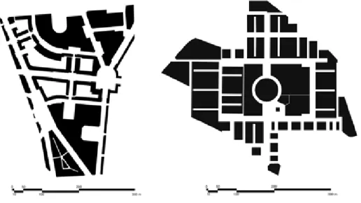
The urban systems of Areeiro and Portela have different historical background. Areeiro is situated in the north side of Lisbon city and is crossed by the main streets, which compose the early XX century urban structure of the city. The plan was developed by architect João Faria da Costa (1906-1971) and is dated from 1946. It was a public urbanization of previously expropriated property with an area of 44 hectares, foreseeing 10.800 inhabitants and a density of 196 inhabitants/hectare (Table 1) (Figure 3). The plan was destined for middle and upper classes. Mainly for residential use, it was provided with several public facilities: schools, church, theater, and local market.
Figures 3 – Figure/ground map of Areeiro (left) and Portela (right) urban plans. buildings (black) and open space (white)
Source: Own Elaboration
table 1 – Housing estates design program UrbAN
PLAN ArEA(ha) sPAcE (%)OPEN DWELLINGs POPULAtION DENsItY INHAbItANts tYPOLOGY DEVELOPEr AUtHOr
AREEIRO
(1946) 44 49 2160 196 10800 Housing blocks City Council of Lisbon Arch. Faria da Costa PORTELA
(1970) 54 39 4500 342 18500 Housing blocks and towers Private Entrepreneur Arch. Fernando Silva
Source: Own Elaboration
The plan layout presents a hierarchy of urban streets composed by three levels. The first level is composed by the three main axis which extend outside the plan area and are part of the global structure of the city: Av. João XXI, Av. Roma and Av. Almirante Reis. The secondary arteries don’t continue outside de plan and have a more residential and local character: Av. Paris, Av. Madrid and Av. Guerra Junqueiro. Finally, the third level of streets are very short and establish the connection between the two previous levels.
Along with the street hierarchy, formal public spaces (Plazas of Areeiro, Londres, Pasteur, João do Rio and Afrânio Peixoto) implemented a strong control over the entire image of the city and reinforces the distinctiveness and symbology of this urban area associated with
Estado Novo dictatorship. The buildings were very homogeneous, facing public space and ranging between four and six floors providing a strong identity of the whole.
An important feature of the urban plan of Areeiro was the establishment of public green spaces inside the urban blocks, which was traditionally private space. Regulations controlled plot division, size and typology of the building as well as uses and functions.
The urbanization of Portela (1965/1970) represents a very different approach towards the built environment.Portela is a suburban area of the city of Lisbon surrounded by heavy traffic lanes. Designed by the architect Fernando Silva (1914-1983), it was a private initiative and a speculative investment which transformed a rural area into a dominant residential and functional zoning for middle upper classes.
The area of the plan comprehends 55 hectares. The population estimated was 18.500 inhabitants with a density of 336 inhabitants/hectare - the housing estate with the highest population density identified in Lisbon region (Guarda, 2016), (Table 1), (Figure 3).
The plan is very regular with an orthogonal geometry dominated by north-south symmetry axis which centralize community facilities. Despite being an enclosed urban structure it reveals a formal geometry which embraces the surrounding environment. At the center of the orthogonal axes an expressive circular building dominates the whole plan. This strong geometry is also pursued by the scale of the buildings. Everything is regulated according to a unitary global order.
The urban model resembles the cosmic city described by Kevin Lynch (1981). Understood as a geometrical organization of static objects (buildings), it is a space to be apprehend at once; the principles of classical composition, such as symmetry, scale, monumentality and centralization are allusive. The influences of the modern movement are also visible: functional zoning, traffic separation, buildings with independent entrances from the street are common features of this period.
The repetition of tower-blocks with similar typology and density reinforces the notion of global order at all scales. The repetition of elements with similar relationships results in a deeply rational order, thus contributing towards the notion of a symbolic space where uses are strongly formalized by geometric attributes (Hillier, 1996: 186-187).
The arrangement of buildings and the space between them followed principles of separation and differentiation between public zones and semi-private areas. The design of space enunciates the separation between local inhabitants and visitors to avoid the attraction of the popular neighborhood nearby - Moscavide. This objective was clearly stated by the architect Fernando Silva in the memorandum of the plan (1970) with a proposal of nonexistent interface between buildings and the street.
Concerning the percentages of open space (Table 1), we notice major differences between Areeiro and Portela, with 49% and 39% respectively. In Portela, the public spaces correspond mainly with street network. There are no formal public spaces like plazas. Areeiro represents the opposite case where a clear hierarchy of public spaces are presented. Nevertheless, and despite the significate number of formal plazas, the percentage of open space is explained by the area inside the urban blocks which is for public use (Figures 3). These spaces have great importance for the social life of the neighborhood because they create diversity of activities and uses of public space.
6.2 the street network regional context: the dual structure of the city
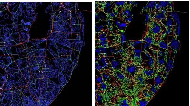
Before we analyze space configuration of the urban plans of Areeiro and Portela we will look at the street network regional context within the city of Lisbon. Building on the axial map for the metropolitan area of Lisbon developed by Teresa Heitor and João Pinelo we constructed the segment map in Depthmap. The syntactic measures calculated with graph analysis were choice and metric mean depth (radius 1000) as described in section 4. The objective was to identify the dual structure of the city of Lisbon, made up of a dominant foreground network, marked by linear continuity and background network with less linear continuity:
“The foreground network is made up of a relatively small number of longer lines, connected at their ends by open angles, and forming a super-ordinate structure within which we find the background network, made up of much larger numbers of shorter lines, which tend to intersect each other and be connected at their ends by near right angles, and from local grid like clusters” (Hillier, 2009: 8) (Figures 4). Each part of the duality exploits the relation between space and movement in a different way. On the one side there is a public space process which gives rise to the global structure of the city bringing people together and maximize movement and co-presence (foreground). On
the other side there is a residential space process, which uses space to restrain and structure movement in the image of residential culture of some kind, and how it seeks to structure relations between inhabitants and strangers (Hillier, 2005: 20).
Figure 4 – the dual structure of the city: Foreground structure, t1024 choice (right) and Background
structure, metric mean depth r1000 (left)
Source: Own Elaboration
As we can see the street network of Areeiro (mainly in the limits of the plan) belongs to the foreground structure (red, orange and yellow) which is the global structure of the city (Figure 4). Segment analysis processed for regional street network detects this structure using the measure of choice. Global structures in cities are recognized as continuous linear connections that afford shorter journeys from all origins to all destinations. This signifies that Areeiro is part of the natural growth process of the city. It is connected with the ‘supergrid’ structure of the city that tends to maintain the highest values for choice that measures ‘through movement’ potentials.
Portela doesn’t participate in the foreground structure of the city. Instead, it belongs to the other side of the dual city - background structure (blue) which is formed by the local and residential structures of the city (Figure 4). Segment analysis of the regional street network also detects this structure using the measure metric mean depth with radius 1000. Local structures in cities are recognized as a discontinuity in the urban street network and this measure shows the effect of discontinuities that result from the block pattern and metric density showing distinct areas in cities. This means that Portela, as a residential area is part of the local structure which forms the patchwork of the city where the relationship between the inhabitants and the strangers is restrained. It is disconnected from the regional street network.
The understanding of the relationship of the case studies with the dual structure of the city gives us a clear impression of the character of the housing states and explains the different results we found at the next step of the analysis.
6.3 convex and axial map analysis
The use of configurational analysis in the housing estates aims to identify spatial patterns related with social organization according to space syntax methodology. The analysis conducted was done according with the original plans and the figure/ground layout of buildings (black) and open space (white). First, we trace the convex map partition and the axial line map following the rules of the fewest number of fattest spaces and the fewest number of the longest lines which compose the open space in each plan. After the construction of these maps we calculated in Depthmap the syntactic measures of connectivity, integration HH and intelligibility, described at the section 5, both for convex and axial techniques. Finally, we also represented the network of convex spaces as a justified graph for better interpretation of the concept of “trees and semi-lattices” described in section 2.
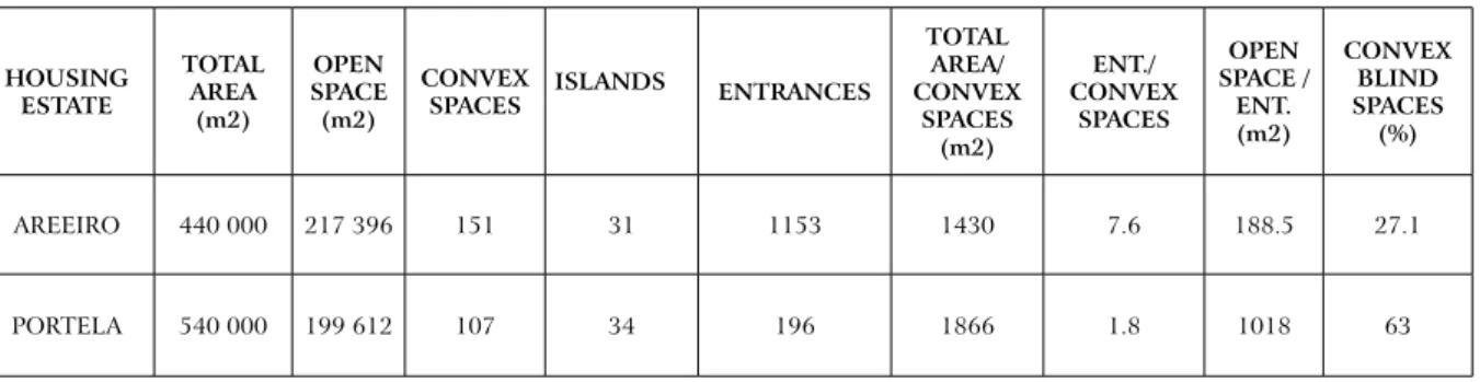
Portela has a lower number of convex spaces (107) then Areeiro (151). However, the average size of those spaces are bigger in Portela (1.866 m2) then Areeiro (1.430 m2) (Table 2). This is a direct consequence of the spatial plans layout. The absence of formal public spaces in Portela diminish the number of convex spaces. Convex space partition follows street layout and creates elongated convex space units which difficult the creation of places for co-presence (Figure 3).
table 2 – convex spaces: Quantification of the analytical variables HOUsING EstAtE tOtAL ArEA (m2) OPEN sPAcE (m2) cONVEX
sPAcEs IsLANDs ENtrANcEs
tOtAL ArEA/ cONVEX sPAcEs (m2) ENt./ cONVEX sPAcEs OPEN sPAcE / ENt. (m2) cONVEX bLIND sPAcEs (%) AREEIRO 440 000 217 396 151 31 1153 1430 7.6 188.5 27.1 PORTELA 540 000 199 612 107 34 196 1866 1.8 1018 63
Source: Own Elaboration
table 3 – Axial lines: syntactic measures calculated with software Depthmap 10 HOUsING
EstAtE AXIAL LINEs GrID AXILItY cONEctIVItYmax; min; aver. INtEGrAtION HHmax; min; aver. INtELIGIbILItY
AREEIRO 42 0.31 11; 1; 4.1 2.54; 0.82; 1.42 0.66
PORTELA 52 0.26 14; 1; 3.5 3.19; 0.89; 1.68 0.80
Source: Own Elaboration
The average number of entrances or space constitution of each convex space is also much lower in Portela (1,8) than in Areeiro (7,6). These fact is explained in part by the map of blind spaces (yellow spaces) presented in Figure 5. In Portela, 63% of the convex spaces are blind, while Areeiro has only 27,1% of those spaces.
Although the number of convex spaces be greater in Areeiro then in Portela, the number of axial lines (lines of sight) is smaller in Areeiro (31) then in Portela (34). These results from the fact that the size and shape of the urban blocks (islands) optimize the circulation and accessibility. Thus, a less number of lines to cross the street network is needed, (Figure 7).
Connectivity applied to axial line map measures the lines that are directly connected to a space. The average value for this measure is higher in Areeiro (4.1) than in Portela (3.5). Fourteen lines are connected to the most integrated street in Portela (Av. Descobrimentos)
while eleven lines are connected to the most integrated street in Areeiro (Av. Guerra Junqueiro / Av. Roma). However, many lines in Portela (16) have only 1 connection, while in Areeiro those lines are just a few (3).
Figures 5 – convex map partition with information of blind walls (yellow)
Source: Own Elaboration
Figures 6 – Integration map overlaid with the interface map (constitution of space)
Source: Own Elaboration
Figures 7 – Integration map overlaid with the interface map (constitution of space)
Integration measures how deep or shallow a space is in relation to all other spaces in the system. In other words, how close each space is from all others. This measure is slightly higher in Portela (1.68) than in Areeiro (1.42). It follows the pattern of connectivity and illuminates the integration core (i.e. the highest 10% values) in both systems (Figure 7).
The relation between building entrances and the integration maps (convex and axial) highlights the previous findings. Figures 6 and 7 indicate that buildings access in Portela is always made by the most segregated spaces (green and blue). Unlike in Areeiro where the most integrated spaces (red, orange) are also the most constituted ones.
The intelligibility of the system (ranging between 0 and 1) is high in both cases: 0.66 (Areeiro) and 0.80 (Portela), meaning that from a local position it is easy to understand the global structure of plan.
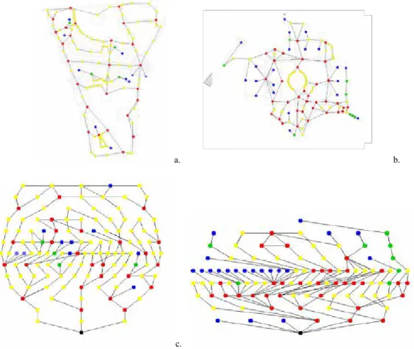
Figure 8 shows other type of convex map representation - justified graphs using the software JASS (Koch, 2004). In this diagrams one can read the degree of ringness of each plan in order to identify patterns of order and structure in space networks. Areeiro have more spaces that are usually positioned on one or more rings ofmovement in the network. Portela has more spaces which are characterized as dead-end spaces (blue spaces) or that are connect to spaces in a graph without being part of any ring of movement (green spaces). Comparing these structures with the Alexander’s model described in section 2 one can say that Portela is more tree like while Areeiro is more a semi-lattice.
Figure 8 – Justified Graphs with the root in the most integrated convex space calculated with JAss software: Areeiro (a. and c.); Portela (b. and d.)
a. b.
c. d.
Blue spaces – spaces which are characterized as dead-end spaces and connect to no more than one space in a graph; Green spaces – spaces that connect to two or more spaces in a graph without being part of any ring of movement; Yellow Spaces – spaces that are usually positioned on one ring of movement; Red spaces – spaces that must be in a joint location connecting
7. DIscUssION AND cONcLUsIONs
A strength of this study is that it relied on objective data regarding a number of measures and variables of space, that helped to evaluate the spatial performance of two urban plans produced from two very different conceptual ideas of city - traditional vs modern. Although the sample is very discreet, it makes the point about the relation between these two kinds of city and two ways of thinking about space - holism vs rationalism.
Space syntax tools and techniques proved to be essential in understanding the configurational proprieties of the urban systems (housing estates) both in qualitative and quantitative way. Although the analysis was diachronic, giving particular acuity to the original plans, the detected configurational attributes demonstrate a set of spatial patterns and respective variations.
The graph representation of street networks through elementary components of space turns possible to interpret the plan layouts according with mathematical principals. While the plan of Portela is clearly a tree, the Plan of Areeiro follow the mathematical principles of a semi-lattice. As a consequence, the strict hierarchy of Portela supports only a small percentage of relations between the elementary components of space, while the overlapping structure of Areeiro supports more easily the relationship between the parts and whole turning this neighborhood much more alive.
Considering the space organization, the design options brings out evident implications in the social structure of the space. The study clearly shows that Areeiro possess a number of features that are likely to support social and public space activities while Portela was designed to segregate inhabitants from its neighbors (visitants). If the reason for any spatial system is to promote the relationship between the two social groups that use it (inhabitants and visitants) then we can conclude empirically that Areeiro is a more successful urban space than Portela.
The results have shown that although resulting from a single plan, they present big differences in terms of street life affordances, which are related with the way the plan addresses the structure of a tree (Portela) or a semi-lattice (Areeiro). In Portela the space is formalized to accomplish certain social conditions, and the functions of space are drawn therefore in the space in a centralized way. Areeiro despite following the same premises, encompass a more distributed structure, with multiple links between the local and global scale of the city and within the neighborhood plan, which configure a richer and livable urban system.
Despite the features of each plan layout the most important aspect which distinguish Portela and Areeiro is their relationship with the dual structure of the city which in turn influences the performance of each urban system. While Areeiro is an integrant part of the structure or skeleton of the city (foreground), Portela is a separate piece which compose the patchwork of the metropolitan region (background).
Finally, it is important to notice that space syntax analysis allowed the understanding of a virtual community and its social life by measuring the affordances of space. Future work should complement the syntactic analysis with direct observations of people and its behavior as well as the main activities in place. For now, we believe that good correlations between the direct observations and syntactic measures will be found.
REFERENCES
Alexander, C. (1966). A city is not a tree. Design Magazine. 206: 46-55.
Al_Sayed, K., Turner, A., Hillier, B., Lida, S. and Penn, A. (2014). Space syntax methodology. A teaching textbook for the MSc Spatial Design: Architecture & Cities. Bartlett School
Bafna, S. (2003). Space Syntax. A Brief Introduction to its Logical and Analytical Techniques.
Environment and Behavior. 35(1): 17-29.
Conroy, R. (2000). Spatial Navigation in Immersive Virtual Environments. Ph.D. Thesis. Faculty of the Built Environment, University College of London. 249 pp.
Guarda, I. (2016). Análise Configuracional dos Grandes Conjuntos Urbanos na Região de Lisboa
(1945-1974): Contributos da Sintaxe Espacial para a História de Arte como História da Cidade. Ph.D. Thesis. Department of Art History, Faculdade de Ciências Sociais e Humanas, Universidade Nova de Lisboa. 251 pp.
Hanson, J. (2000). Urban transformations: a history of design ideas. Urban Design
International. 5(2): 97-122.
Hillier, B. and Hanson, J. (1984). The Social Logic of Space. Cambridge University Press. Cambridge. ISBN: 0521367840.
Hillier, B. (1988). Against Enclosure. In: N. Teymur, T. Markus & T. Wooley (eds.),
Rehumanising Housing. Butterworths. London.
Hillier, B., Penn, A., Hanson, J., Grajewski, T. and Xu, J. (1993). Natural movement: or configuration and attraction in urban pedestrian movement. Environment and Planning B:
Planning and Design. 20(1): 29-66.
Hillier, B. (1996). Space is the Machine. University College of London. London. ISBN: 978-0521645287.
Hillier, B. (2005). The Art of Place and the Science of Space. World Architecture. 185: 96-102. Hillier, B. and Vaughan, L. (2007). The City as One Thing. Progress in Planning. 67(3):
205-230.
Hillier, B. (2009). Spatial Sustainability in Cities. Organic Patterns and Sustainable Forms.
Proceedings of the 7th International Space Syntax Symposium. In: D. Koch, L. Marcus and J. Steen (eds.), Stockholm. KTH Royal Institute of Technology, K01:1 – K01:20.
Heitor, T. and Pinelo-Silva, J. (2015). A Sintaxe Espacial e o Ambiente Construído – Análise Morfológica. In: Oliveira, V., Marat-Mendes, T. & Pinho, P. (eds.), O Estudo da Forma
Urbana em Portugal. Universidade do Porto Edições. Porto.
Koch, D. (2004). Spatial Systems as Producers of Meaning - the idea of knowledge in three public
libraries. Licentiate Thesis. KTH School of Architecture. Stockholm.
Legeby, A. (2010). From Housing Segregation to Integration in Public Space. A Space Syntax Approach Applied on the City of Sodertalje. The Journal of Space Syntax. 1(1): 92-107. Lynch, K. (1999 [1981]). A Boa Forma da Cidade. Edições 70, Lisboa.
Marshall, S. (2005). Streets and patterns: The structure of urban geometry. Spon Press. London. Nunes, J. P. S. (2011). Florestas de Cimento Armado. Os Grandes Conjuntos Residenciais e a
Constituição da Metrópole de Lisboa (1955- 2005). Fundação Calouste Gulbenkian. Lisboa. Pereira, M. (1994). O Processo de Decisão na Política Urbana. O Exemplo da Costa do Sol. Ph.D. Thesis. Departamento de Geografia e Planeamento Regional. Faculdade de Ciências Sociais e Humanas, Universidade Nova de Lisboa. Lisboa. 356 pp.
Seamon, D. (1994). The life of the place: A phenomenological reading of Bill Hiller’s space syntax. Nordisk Arkitekturforskning [Nordic Journal of Architectural Research]. 7: 35-48. Turner, A. (2011). UCL Depthmap: Spatial Network analysis Software, version 10.14. University
College of London, VR Centre of the Built Environment. London.