CAMINHOS DE GEOGRAFIA - revista on line http://www.ig.ufu.br/revista/caminhos.html ISSN 1678-6343
Instituto de Geografia ufu Programa de Pós-graduação em Geografia
Caminhos de Geografia Uberlândia v. 12, n. 39 set/2011 p. 283 - 296 Página 283 ENVIRONMENTAL IMPACT OF FLOOD AND THEIR SUSTAINABLE MANAGEMENT IN
DELTAIC REGION OF WEST BENGAL, INDIA1
Vibhas Chandra Jha Professor and Ex-Head Department of Geography,Visva-Bharati University Santiniketan731235, West Bengal, India, [email protected] Haraprasad Bairagya Researcher, Dept. of Geography, Visva-Bharati University, Santiniketan, Birbhum, West Bengal, India, [email protected] ABSTRACT
Flood is one of the basic factors for sustainable development and environmental management in the humid, tropical and sub-tropical regions. Flood characteristics decide the status of the terrain for its capability for sustaining the increased population of that area. In this paper, an attempt has been made to analyze the flood characteristics using the Gumble‟s Method and their impact on sustainable development and environmental management in the Deltaic Region of West Bengal, India. The Murshidabad District of the West Bengal State, India has been selected as a case study to assess the environmental impact of flood and their characteristics which includes different measures like flood elevation, discharge, volume and duration. The physical and socio-economic condition of the study-area have also been analyzed. An attempt has also been made to suggest some measures for the development of the study-area.
Key Words: Flood, Flood Plain, Flood Characteristics, Gumble‟s Method, Sustainable Development and Environmental Management
INTRODUCTION
Flood in deltaic region is a disaster which can destroy the total environmental set up of the area. It causes river bank erosion, depression of land, shifting of river course, river channel widening etc due to it‟s high discharge, elevation, volume and longer duration. It leads to create agricultural deficiency, unemployment, sexual exploitation, and even starvation death. So, proper and scientific management of the flood in this district is necessary to solve the environmental problems to give better life for the next generation population. The district of Murshidabad is in the northern part of Brahmaputra Delta. It is a low flat terrain having elevation of 10-30m above the m.s.l in Ganga Brahamputra Delta. Delta building processes are active over southern part, while northern part in which the Murshidabad district is situated, shows the characteristics of a mature deltaic landscape. This Delta is named as „khadar‟. The „khadar‟ deposits are as a resultant feature confined to the vicinity of the present channels. The clays have less „Kankar‟ and the organic remains. The „Khadar‟ imperceptibly merges into the deltaic and other accumulations of the pre-historic times. The delta of Ganga-Brahmaputra is merely the sea ward prolongation of the „Khadar‟ deposits of the respective river valleys. The present study aims to analyze the flood characteristics using the Gumble‟s Method and their impact on sustainable development and environmental management in the Deltaic Region of West Bengal, India. To assess the environmental impact of flood, the following objectives have been considered relevant for this study. Various Workers in the field of applied hydrology have attempted as basics and case studies in different parts of West Bengal. Particular mention may be made of P.K. Basu, M.C.Burke, V.T. Chow, D.R Maidment, L.W Mays, D.N Wadia, Aveek Datta, Anjan Dasgupta, S. K. Garg, „O‟ Mally, Chandan Ray, K Subramanya, K Rudra, and Islam Khan Zafarul.
1
Recebido em 20/07/2011
Environmental impact of flood and their sustainable management in deltaic region of West Bengal, India
Vibhash Chandra Jha Haraprasad Bairagya
Caminhos de Geografia Uberlândia v. 12, n. 38 jun/2011 p. 283 - 296 Página 284 In fact, the deltaic parts are characterized by specific characteristics of stream rises and their impacts on flood plains which affects the sustainability of the local people with severe environmental consequences. This paper is based on the findings of the field data and the empirical results. It is concerned with:
To analyse the flood characteristics such as flood elevation, discharge, volume and
duration in the study-area;
To apply the Gumbel’s method for analyzing the River Discharge and its Flood
Frequency;
To find out the Environmental Problems related to flood in the study-area, and;
To suggest some measures for the sustainable development and management of the
study-area.
Data Base and Methodology
The present study is based on the flood data of 35 years of the region. The quantitative-statistical method i.e. Gumbel‟s method has been adopted to analyse the flood frequency. The topographical sheets on 1:50,000 (SOI), and the Satellite Imageries of IRS P6, LISS III Precision geocoded on 1:50000 of December2006, field photographs as well as daily, monthly and annual rainfall data for the period of 10 years have been used to draw the results of the present investigation.
Study-Area
The Murshidabad District covers an area of 5324 km2 out of 1,30,00km2 area of total delta composed of repeated alternations of clays, sands and marls with recurring layers of pit, lignite and some forest beds (Wadia 1975, pp370). The Murshidabad District is prone to flood almost in every year due to it‟s geographical location. It is situated almost in the middle part of the West Bengal flood plain. The northern boundary of the district is confined by Ganga River. This district is almost equally divided into east and west to the south flowing Bhagirathi River, which is an important tributary of River Ganga. The district Murshidabad centrally located in West Bengal lies between the Latitude of 23043'30"N to 24050'20"N and longitude of 87049'17"E to 88044'00"E (Fig.1). River Ganga forms the north and eastern boundary and separates it from Bangladesh. Extending over an area of 5,324 sq. km, the district has 58, 63,717 persons (30, 04,385 are males and 28, 59,332 females census 2001).
Environmental impact of flood and their sustainable management in deltaic region of West Bengal, India
Vibhash Chandra Jha Haraprasad Bairagya
Caminhos de Geografia Uberlândia v. 12, n. 38 jun/2011 p. 283 - 296 Página 285 Flood Characteristics
Man must acquaint himself with the characteristics of floods if he is to control them. Floods vary as the weather-from month to month and year to year. The first step in becoming better acquainted with flood is to measure them.
The important measures are: Flood elevation, Flood discharge, Flood volume and Flood duration
Flood Elevation
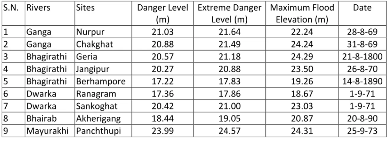
The elevation of a peak is the most often used fact of all flood data. The recording of the peak elevation should be done carefully. The maximum flood height at a staff gauge may be noted by an observer at the time of flood peak or may be indicated on the gauge. Table-1 shows the maximum flood level seen in different rivers of Murshidabaddistrict.
Table 1: Maximum Flood Elevation
.
Flood DischargeFlood discharge is an important characteristic of flood. It can be measured. In fact it indicates the quantum of flood and it‟s capability of destruction. The principal river Bhagirathi and its tributaries are responsible for Murshidabad flood condition. Thus, the Bhagirathi river discharge and its flood frequency analysis can be analysed using Gumbel‟s method.
Flood Frequency Analysis by Gumble’s Method
Chow (1951) has shown that most frequency – distribution functions applicable in hydrologic studies can be expressed by the following equation known as the general equation of hydrologic flood frequency analysis:
XT =X+KSd
Where, XT = value of the variate X of a random hydraulogic series with a return period T, X = mean of the variate ,Sd= standered deviation of the variate , k= frequency factor which depends upon the return period,T and the assumed frequency distribution. The commonly used frequency distribution function for the prediction of extreme flood values is the Gumble‟s method. This extreme flood value distribution was introduced by Gumble(1941)and is commonly known as Gumble‟s distribution .It is the most widely used probability distribution function for extreme values in hydrologicstudies and meteorological studies for the prediction of flood peaks,max. rainfall, maximum wind speed etc. According to Gumble, a flood as the largest of the 365 daily flows and the peak annual series of flood flows.The general formula for the prediction of extreme flood values and it‟s probability of occurance , is given by Gumble as below:
Qp = Q¯ +K.Sd n-1
S.N. Rivers
Sites
Danger Level
(m)
Extreme Danger
Level (m)
Maximum Flood
Elevation (m)
Date
1
Ganga
Nurpur
21.03
21.64
22.24
28-8-69
2
Ganga
Chakghat
20.88
21.49
24.24
31-8-69
3
Bhagirathi Geria
20.57
21.18
24.29
21-8-1800
4
Bhagirathi Jangipur
20.27
20.88
23.50
26-8-70
5
Bhagirathi Berhampore
17.22
17.83
19.26
14-8-1890
6
Dwarka
Ranagram
17.36
17.86
18.67
1-9-71
7
Dwarka
Sankoghat
20.42
21.00
23.03
1-9-71
8
Bhairab
Akherigang
18.44
19.05
20.87
20-8-90
9
Mayurakhi Panchthupi
23.99
24.57
24.31
25-9-73
Environmental impact of flood and their sustainable management in deltaic region of West Bengal, India
Vibhash Chandra Jha Haraprasad Bairagya
Caminhos de Geografia Uberlândia v. 12, n. 38 jun/2011 p. 283 - 296 Página 286 Where, Sd n-1 = standerd deviation of the sample size, N = √∑ (Q¯-Q) ²/√N-1,Q = Flood discharge, K = Frequency factor expressed as K =Yt-Y¯n/Sn
in which Yt = reduced variate, a function of T and is given by Yt = - [In.In T/T-1]
Or, Yt = -(0.834+2.303LogLogT/T-1), Yn = reduced mean , a function of sample size N table. Sn = reduced standard deviation, a function of sample size N. The value of Yn and Sn is given in Gumble‟s extreme value distribution in Table 2.
Table 2: Reduced Mean Yn in Gumble’s Extreme Value Distribution (Sample Size N)
N 0 1 2 3 4 5 6 7 8 9 10 .4952 .4996 .5053 .5070 .5100 .5128 .5157 .5181 .5202 .5520 20 .5236 .5252 .5268 .5283 .5296 .5309 .5320 .5332 .5343 .5353 30 .5362 .5371 .5380 .5388 .5396 .5402 .5410 .5418 .5424 .5430 40 .5436 .5442 .5448 .5453 .5458 .5463 .5468 .5473 .5477 .5481 50 .5485 .5489 .5493 .5497 .5501 .5504 .5508 .5511 .5515 .5518
Table 3: Reduced Standard Deviation Sn in Gumble’s Extreme Value Distribution
N 0 1 2 3 4 5 6 7 8 9 10 .9496 .9676 .9833 .9971 1.0095 1.0206 1.0316 1.0411 1.0493 1.0565 20 1.0628 1.0696 1.0754 1.0811 1.0864 1.0915 1.0961 1.1004 1.1047 1.1086 30 1.1124 1.1159 1.1193 1.1226 1.1255 1.1285 1.1313 1.1339 1.1363 1.1388 40 1.1413 1.1436 1.1458 1.1480 1.1499 1.1519 1.1538 1.1557 1.1574 1.1590 50 1.1607 1.1623 1.1638 1.1658 1.1667 1.1681 1.1696 1.1708 1.1721 1.1734
Calculation for Peak Discharge and Flood Frequency of the River Bhagirathi by Gumble‟s Formula at Berhampore is given here below. In fact, peak annual flood flow is taken into consideration (Table 4).
Calculation:
Mean / average discharge=Q¯=∑ Q/ N =67499/34=1985.3 cumec
Standard Deviation = Sd n-1= √∑ (Q¯ -Q) ²/√N-1 =√ 13488000/√34-1=√408727.27=639.32 cumec
Now Gumble‟s Frequency Factor K = (Yt-Y¯n)/Sn(where Y¯ n = expected mean,
Sn=expected
Standerd Deviation collected from Gumble‟s table and Yt = (in.in.T/T1) = -(0.834+2.303logLogT/T-1)
From the Table 5, the magnitude of flood having frequency of 10,20,30,40,50,80 and
100 years have been calculated as 2956, 2727, 3609, 3757, 3896, 4152 and
4299cumecs respectively. So above 40 thousand cumec, high magnitude of flood
discharge is noted at Behrampur location. Fig.2 shows the discharge- frequency
curve of Berhampore which has a very gentle slopped curve . The curve is
characterized by almost uniform discharge throughout the flood period in different
years. A very little distortion in the curve is noted which indicates that the evidence of
very little influence of Farakka Reservoir- discharge on this river in the fluctuation of
regular flow during flood period. It is also proved that the river is highly perennial
almost after construction of the barrage.
Environmental impact of flood and their sustainable management in deltaic region of West Bengal, India
Vibhash Chandra Jha Haraprasad Bairagya
Caminhos de Geografia Uberlândia v. 12, n. 38 jun/2011 p. 283 - 296 Página 287
Table 4: Peak Annual Flood Flow
YEAR Annual Peak Discharge cumec (Q) Order(m) Q¯-Q (Q¯-Q)² Frequency (T=N+1/m ) Max Probable Flood(in%)P= 100/T 1971 3359 1 -1374 1887876 35 2.85 2000 3243 2 -1258 1582564 17.5 5.71 1987 3234 3 -1249 1560001 11.67 8.57 1996 3079 4 -1094 1196836 8.75 11.43 1984 3062 5 -1087 1181569 7 14.29 1999 2781 6 -796 633616 5.83 17.15 1991 2504 7 -519 269361 5 20 1990 2303 8 -318 101124 4.38 22.83 1989 2264 9 -279 77841 3.89 25.707 1978 2255 10 -270 72900 3.5 28.57 1993 2238 11 -253 64009 3.18 31.44 1986 2207 12 -222 49284 2.91 34.36 1988 2054 13 -60 3600 2.69 37.17 1969 2037 14 -52 2704 2.5 40 1998 2014 15 -29 841 2.33 42.91 1995 1975 16 10 100 2.18 45.87 1973 1782 17 203 41209 2.06 48.54 2001 1774 18 211 44521 1.94 52.36 1980 1695 19 290 84100 1.84 54.35 1976 1630 20 355 126025 1.75 57.14 1992 1590 21 395 156025 1.67 59.88 1983 1559 22 426 181476 1.59 62.89 1970 1556 23 429 184041 1.52 65.789 1974 1516 24 469 219961 1.46 68.49 1979 1511 25 474 224676 1.4 71.43 1997 1480 26 505 255025 1.35 74.07 1994 1457 27 528 278784 1.3 76.92 1968 1426 28 559 312481 1.25 80 1981 1373 29 612 374544 1.21 82.64 1985 1367 30 618 381924 1.17 85.47 1977 1356 31 629 395641 1.13 88.495 1982 1347 32 638 407044 1.1 90.9 1975 1282 33 709 502681 1.06 94.33 1972 1189 34 796 633616 1.03 97.08 Sum 67499 13488000
Flood Volume
Flood volume in Murshidabad District is also calculated at Berhampore location.
It is observedthat the flood volume in Bhagirathi was 176686cumec in 1987 which was maximum during the year 1968- 2001.The other larger flood volumes were during the year 1971, 1999 and 2000 having the volume of 163268, 164516, 175052 cumec respectively. The degree of devastation during these years can be visualised.
Flood Duration
Murshidabad district has a history of long flood duration. In Bhagirathi River the average duration continues for more than a month continuously and the maximum duration was of 59 days in the year 1971.
CAMINHOS DE GEOGRAFIA - revista on line http://www.ig.ufu.br/revista/caminhos.html ISSN 1678-6343
Instituto de Geografia ufu Programa de Pós-graduação em Geografia
Caminhos de Geografia Uberlândia v. 12, n. 38 jun/2011 p. 283 - 296 Página 288 Table 5: Flood Frequency (in Years)
Flood
Frequency
(In Years) T/T-1 LogT/T-1 Log Log T/T-1 Yt = - (.834+2.303 Log LogT/T-1) Expected Reduced MeanYn (From GUMBLE' S Table) Expected Reduced SD=Sn (From GUMBLE'S Table) Yt -Y¯n Frequency Factor K=(Yt -Y¯n)/Sn Sd n-1 K. Sd n-1 (incumec) Q¯ (in cumec) Qp=Q¯+ K.Sd n-1 Probable Peak Discharge (in 1000 cusec) 10 1.11 0.0457 -1.3 2.25 0.5396 1.1255 1.71 1.52 639.32 971.77 1985 2956.77 20 1.05 0.02243 -1.7 2.97 0.5396 1.1255 2.43 1.162 639.32 742.89 1985 2727.89 30 1.03 0.01452 -1.8 3.4 0.5396 1.1255 2.86 2.541 639.32 1624.5 1985 3609.51 40 1.03 0.01115 -2 3.66 0.5396 1.1255 3.12 2.772 639.32 1772.2 1985 3757.19 50 1.02 0.00877 -2.1 3.9 0.5396 1.1255 3.36 2.99 639.32 1911.6 1985 3896.57 80 1.01 0.00561 -2.3 4.35 0.5396 1.1255 3.81 3.39 639.32 2167.3 1985 4152.29 100 1.01 0.00432 -2.4 4.61 0.5396 1.1255 4.07 3.62 639.32 2314.3 1985 4299.33
CAMINHOS DE GEOGRAFIA - revista on line http://www.ig.ufu.br/revista/caminhos.html ISSN 1678-6343
Instituto de Geografia ufu Programa de Pós-graduação em Geografia
Caminhos de Geografia Uberlândia v. 12, n. 38 jun/2011 p. 283 - 296 Página 289 Figure 2: Discharge of Bhagirathi River
Figure 3: Impact of Flood at Kalukhalii
Environmental Problems Related To Flood:Physical Problems:
Some specific problems which are created physically due to flood in the floodplain. Among the problems the most important problems are:
Destruction of natural levee
In case of Bhagirathi River, the destruction of natural levee has been taken place during the all large scale of the same lengths at almost all locations. It is due to the stagnation of huge water relatively in the lower catchments of the district.
Depression of land
Existence of a weaker zone in the subsurface part does not carry heavy water load during flood. Thus, it is responsible for creating depression in the outer surface e.g. there is a big depression existed during 2000 flood at Kalukhali near Subarnamrigi at Murshidabad P.S.
Environmental impact of flood and their sustainable management in deltaic region of West Bengal, India
Vibhash Chandra Jha Haraprasad Bairagya
Caminhos de Geografia Uberlândia v. 12, n. 38 jun/2011 p. 283 - 296 Página 290 Shifting of river course
The eastward migration of Ganges near Panchanandapur [situated at Malda Distr ict, just before the Murshidabad Distrct entrance in the northern side of Farrakka] reduces the distance between two rivers Pagla and Ganga which can take a vital role to make Farrakka Barrage,useless.It was estimated that the distance between two rivers along a fixed line was 8.53kms in 1923,2.05kms in1966,and 0.95km in 1975.It reduced to 300m in 1998. In the month of August 2001, the encroaching Ganga swallowed the narrow interfluves between two rivers. So if those rivers are joined together in future th en the water will flow through Pagla and the present Ganga tract will remain abandoned. Thus Farakka barrage will be useless.
The migrating river course, mainly occurred during flood, can change the district or state administrative boundary and making a big barrage useless because of its destructive nature. Such shifting nature is found in almost all the rivers of the study-area but among them the Bhagirathi river is dominating (Figure 3).
River Channel widening
River channel widening is a perpetual processes in the study-area. It is mainly due to lateral erosion. It is noted that the Groves of the flood plain‟s in the study-area which were developed on the river banks now their locations are existing within the channel beds. Sometimes 30m-100m from the present bank which have submerged. The process of River channel widening repeats in the study-area and responsible for more destruction in the existing floodplains. Surface Channel Scour
During floods, over bank flow is often concentrated in braid-like threads on the flood plain surface. These channels can erode the surface to depth of 30 cm and do not necessarily aggraded during the waning stages of the flow. The confined back channels are more effective agents of both lateral and vertical erosion, the lateral extension of back channel by erosion of the scarp of the adjacent, higher flood plain is commonly observed.
Flood plain stripping
Stripping of floodplains is a process that removes alluvium from floodplains surfaces. In the study area this mechanism operates at a verity of scales. For example, a strip of flood plain alluvium approximately 40 cm in depth and 3 m in width near Bhaghwangola was removed from the flood plain surface along it‟s 300m length. More commonly, flood plains are stripped to 2m depth in width of 30-40 m distance up to 500 m mainly in the relatively upstream areas. If stripping occurs repeatedly in the same place during different flood then it results rills and gullies which ultimately appears as water logging area. Detachment of settlements during the flood and water logging is also one of the important features in the study-area.
Socio-Economic Problems
In the Human development index Murshidabad ranks as 17 th district out of 20 districts in West Bengal (Source: Human Development index report Govt. of West Bengal-2004). Sachar Committee Report (2006) placed Murshidabad as one of the backward districts out of 604 districts in India in terms of literacy opportunities and awareness levels of specifically Muslim women. Incidentally 68% of Murshidabad population is Mushlim [Source: Report of Jabla Action Research Organization, Murshidabad, 2009] The following Flood related Socio-Economic Problems have been noted in the study-area.
Poverty and Migration:
About 1.47% of India‟s rural poor live in Murshidabad district West Bengal State. About 3 million people or 56% of the district‟s rural population are below the poverty line. Agricultural deficiency, unemployment and child labour , child marriage and trafficking factors are mainly responsible for poverty and migration in the study-area.
1. Agricultural deficiency
Although the agricultural land of the study-area is very much fertile but the agriculture productivity is low. It is due to the flood on the agricultura l land. In winter, it gives maximum
Environmental impact of flood and their sustainable management in deltaic region of West Bengal, India
Vibhash Chandra Jha Haraprasad Bairagya
Caminhos de Geografia Uberlândia v. 12, n. 38 jun/2011 p. 283 - 296 Página 291 production but in Rainy season flood washes almost 70% of the total area consequently low production. The River in this area during the flood time is responsible for subsidence and slumping along the banks that also results loss of land of poor farmers. . The river bank erosion and shifting of river courses in the study-area also affect the residents of the villages. Villagers move to upland areas along the river banks during the extreme condition of flood. The loss of land of villagers directly affects the sustainability in the study-area. It increases poverty as well as insists the rural population to migrate for obtaining employment at other places.
Figure 4: Destruction in the study area due to flood near Saktipur and Beldanga
2. Unemployment
The total no of applications on liveregister of employment exchange is 310425 within which only 847 persons are placed. According to the survey report of district rural development authority 1997 and census report 2001, it is noted that about 65.86% population of the study-area are unemployed. It is also noted that out of 65.86% about 92% population belong to female category.
3. Child Labour ,Child Marriage And Trafficking
It is noted that teenagers of the study-area both boys and girls have been working at different places such as domestic maids, as helper at various shops particularly tea shops as well as for house keeping. Early marriage is also well adopted social system in the study-area. These all factors are responsible for a high percentage of dropouts from the schools of the teenagers in the study-are.
4. Sexual Exploitations
Calcutta sex worker Carolyn Sleighteholme and Indrani Sinha(1996) have explained in their book “Guilty without Trial” as – “in the Sanlaap Survey it is found that 70% of the sex workers in kolkata are from West Bengal. Of these almost 30% are from Murshidabad district. The remaining 30% are from outside Bengal in which 15% from Bangladesh”
It is evident from the above data that the rate of sex workers are very high in the Murshidabad district. Thus it is concluded that malnutrition, early marriage, dowry system, school dropouts, poverty and unemployment are the indirect effects of flood, which are also the main causes behind the sexual exploitation in the district.
Environmental impact of flood and their sustainable management in deltaic region of West Bengal, India
Vibhash Chandra Jha Haraprasad Bairagya
Caminhos de Geografia Uberlândia v. 12, n. 38 jun/2011 p. 283 - 296 Página 292 5. Education
According to Human Development Index the Murshidabad district is ranked 17 out of 20 districts in West Bengal in the illiteracy scale. According to 1991 census about 38.28% of the total populations are literate which increased upto 54.35% in 2001 census. It is noted that the school building have been submerged under the water during the flood period. Sometimes the school building becomes shelter of the poor people in the study-area during and after theflood for certain period. After flood the students of the study-area get engaged in re-construction of settlements and work for raising funds for solving the economic problems of the rural flood affected population. Ultimately it also increases the number of dropouts from schools. 6. Health
The district comprises 70 primary health centers and 34 family welfare centers. The primary health centers are sometimes submerged under flood water and consequently the apparatus, medicines and other necessary goods are destroyed. Thus these health centers having very lesser apparatus and medicines which are portable. Very few doctors and nurses are sent for their duties in those area and beds are also not more than 10. On the other hand due to flood, damped weather continues for long time. The sufferer comes to the PHC for treatment a lot becomes upset by not get is medicines. Due to more bushes and rat-holes, snake bites cases are more but they do not get proper medicine in proper time and dies. Ground water contains a dangerous level of arsenic which also creates “black foot diseases”
7. Destruction of Settlement
The dense rural settlements are along the riverside which are highly affected by flood. The townships like Baharampore, Jangipore, Kandi, Salar, Domkol and Jalangi are also located flood prone zone. Almost 60% of the total households are affected by highly elevated flood whereas about 30% of it, are affected almost in every year. Sometimes, the house buildings are totally damaged and the dwellers are bound to be shifted. They sometimes take shelter in school building or in flood centers.
8. Loss of Live-Stock:
In flood period most of the domestic animals are unsecured because:
They can be carried away with flood water and when they are unable to swim or get collision with obstruction, then died.
Sometimes they are submerged by clay-made walls of the houses when these are broken down.
These are affected by various diseases during flood due to bites of harmful insects or different harmful virus and bacteria.
The relief and medical team cannot be sent to the flood affected area in proper time due to damaged transport problems. When it reaches to the area, becomes useless and problem remains unchanged.
9. Industry
Only one agro-based large scale industrie is established in the study-area i.e sugarcane industry at Beldanga. The small scale industries are –silk,ivory carving,small scaled textile industry[almost homely made],metal work,clay model preparation ,bidi industry[home-made siggerate]etc. The other industries are existed in Murshidabad are oil mills, rice mills etc, which are also affected by flood. The productivity decreases during flood due to lack of raw materials or labours that comes from the other villages and communicational drawback. Sometimes rivers are polluted with oils and becomes thick water. This provides great economic loss in these small industries.
10. Transport
Means of transportation in Murshidabad District are railway, roadway, waterway etc. Amongst which waterway is the cheapest mode of communication and easily available during flood. Sometimes the boatman and fisherman pray for flood because of their high income in flood
Environmental impact of flood and their sustainable management in deltaic region of West Bengal, India
Vibhash Chandra Jha Haraprasad Bairagya
Caminhos de Geografia Uberlândia v. 12, n. 38 jun/2011 p. 283 - 296 Página 293 time. The rail and roadways are submerged under water, thus people have no way to travel or transport other than using waterways.
Sustainable Development and Management
In Murshidabad Flood controlling measures are to be taken from physical, Economic and social aspects applicable for Murshidabad district. These are as follows:
1. Physical Measures:
a. River Channel Improvement:
After construction of Farakka Barrage, the river bank erosion at upstream (before berhampore) of Bhagirathi is increased due to high velocity and discharge of water which provides siltation problem at the southern part of the district because of very gentle gradiant. Maximum stagnation occurs due to narrow and si ngle outflow path of Mayurakshi and Dwarka through Hijol and Bhagirathi Rivers (Fig. 4). The river Bhagirathi is getting maximum silt from the rivers of the Rarh region which clogs the Bhagirathi outlet starting from Kalyanpur (Confluence of Mayurakshi).These silt can be reduced by destroying sand bars in the river beds.
b. Proper and scientific Reservoir control: Controlling Measures of Farakka Barrage:
i) Reduction of siltation from the pond: According to Bibhas Barman, Director in Charge, Haringhata Central Library, River Research Institute, siltation reduction from the Farakka barrage can be done by alternative opening of the lock gates by regulators in different sides of the barrage. The change of flow from different sides of the pond may clear silt by reducing water in a systematic interval by controlling regulators.
ii) With the help of early flood prediction water may be released gently with increasing rainfall intensity.
iii) There is an abundant channel of Ganga from „Bhutni chak‟ to Farakka, which was active during 1922-23. It can be utilized by reducing silt as alternative channel to save Farakka Barrage and its utility. It may also be used to reduce pressure from the barrage and will help for flood control. For the implementation of this procedure, another flap gate can be introduced near „Bhutni Chak‟where the abundant channel has started its way.
c. Controlling Measures of Messanjore Dam:
i) Reduction of siltation from the Massanjore Dam storage.
ii) Reduction of water throughout the cyclonic period which above danger level to reduce pressure from the dam.
iii) Increasement of carrying capacity of Tilpara Barrage as the substitute water storage.
iv) Several smaller dams may be constructed in the upstream of Massanjore Dam to reduce pressure from the main Dam.These smaller dams can be utilized for generating hydro-electricity due to its situation in greater elevation by their alternative use etc.
By this way proper and scientific reservoir control can manage Murshidabad‟s flood sustainably. d. Embankment maintenance
To be effective, embankments must be adequately maintained even when there has been no severe flood for several years and local, and even official, perception of flood risk has perhaps lessened compared with other, more immediate demands on scarce resources.
Many embankments have unplanned uses, particularly on roads, but also for growing trees, as temporary shelters during floods, and as permanent shelters for people displaced by erosion.
Environmental impact of flood and their sustainable management in deltaic region of West Bengal, India
Vibhash Chandra Jha Haraprasad Bairagya
Caminhos de Geografia Uberlândia v. 12, n. 38 jun/2011 p. 283 - 296 Página 294 e. Sheet Erosion Control and Soil Conservation By River Bank Protection:
(i) Construction of dyke:
Construction of dyke in the river bank can control it‟s erosion due to getting more rigidity and diversion of river‟s turbulence from the sidewalls towards the middle. So it reduces pressure from river bank and the chance of erosion becomes less. Due to highly rigid guard wall by hard boulders water can‟t erode it quickly and saves the nearer villages, towns or important places as it is done in river Manja in North Bengal.
This is applicable for the non-perennial rivers of the district like Mayurakshi, Dwarka ,Brahmani, Kuya ,Bhairab and Jalangi ,because here erosion occurs only in rainy season and in summer construction can be done properly.
(ii) Geo Web Method:
Geo Web method for river bank protection was introduced by Markin Corporation at Agradwip near Katwa in Bhagirathi River. Some landscape patches in Murshidabad district namely, Jangipur, Beldanga, Kashimbazar and Saktipur where river bank erosion is maximum, this methods can also be used for protection.
(iii) Concretization of River Bank:
It is a very costly method. But it is useful method. Occasionally, this method is used to save the important towns of a region, as it is done in case of Baharampore and feeder canal (whole canal) of the study-area.
It may be applied to save other towns and bigger villages or the danger zones (where there is a chance to connect Bhagirathi with Padma) of this district to protect them. It should be done with boulder and cement for its longivity.
2. Flood Plain Planning
The main aim of flood plain planning is to use of floodplain properly and to reduce destruction during flood. The study of flood intensity ,discharge , volume ,duration etc. are very important to reduce destruction and damage in the floodplain. It needs regional division of the flood as it is suggested by Central Water Commission (CWC) of India in 1975.The suggestions are also permitted by Central Flood Control Commission and Central Bar Ayog in1980. According to the recommendation of these commissions, 1:15000 scale map was prepared with a contour interval of 25c.m. for the country. In India, 1 lakh km² area was specified in this project. After preparation of map it is noted that about 30,268 km² areas in West Bengal is identified as flood prone area including the Murshidabad district which may be highly considered for such mapping. The National Remote Sensing Agency (NRSA) has been working hard to prepare such maps accurately at micro-level. It will certainly be meaningful for saving the loss of socio-economic property of the district. Ultimately, it is useful in landuse planning of the study-area. a. Cut-off channel:
The effects of a cut off channel are somewhat similar to those of channel improvement. In fact, it increases the channel improvement, channel slope and velocity. In a meandering channel, the land between the two portions of a bend may dwindle to a narrow neck, which may easily be cut across by natural flood flow.
b. Flood Moderation by construction of terraces:
Terraces are ditch type excavation ,following the contour of the ground having a base of about 1.5m to 2 m and a usual height of 15cm. to 20cm. These are closely spaced and significant to store surface run-off without over-topping. The water remains in these ditches till it infiltrates into the sub-surface zone. This requires a short time and becomes dry. It is also ready for the next rain. They thus serve to reduce flood flow, prevent soil erosion, and increase ground water supply. (Garg 2007,pp500). This method can be applied for Bhagirathi river flood control. c. Removal of Human Encroachment along river bank:
From the Mayurakhi river Bank, the Godda village is to be shifted as well as the enbankment should be made wider to increase water carrying capacity so that large volume of water can get
Environmental impact of flood and their sustainable management in deltaic region of West Bengal, India
Vibhash Chandra Jha Haraprasad Bairagya
Caminhos de Geografia Uberlândia v. 12, n. 38 jun/2011 p. 283 - 296 Página 295 discharged to „Hijol‟. The other villages namely, Maliandi, Kasipur, Balichuna, Talgram have also been obstructing flood water discharge and responsible for maximum damages in the study-area. Thus, there is an urgent need to shift these villages at appropriate locations. Along the river Bhagirathi the villages like Shimuldanga, Masimpur, Saktipur, Mahula, Sargachiy, Bidupara and Ramnagar should be uprooted with a view to protect them from flood damage. These measures will certainly help flood water for its quick discharge in the study-area.
d. Early warning Early warning:
as a means of reducing a flood hazard, has been a strategy followed throughout history with the aim of living with floods. A flood early warning system includes the components like Prediction, Interpretation, Message construction, Communication, Response, Review and examining the various aspects of the system with a view to improving their performance. If flood warning is properly done then the loss of property and lives can be saved on time.
e. Role of flood insurance:
Insurance has three main role in flood management. First, it provides a means of reimbursement of damage costs, allowing the victims to get recovered from their loss. Second, it confines irregularity in cost assessment and flood losses over both time and space. Third, it can be used to encourage actions, at individual and collective levels for reducing the exposure of flood loss. If it is done with international agencies then, flood losses in one country may therefore be ultimately spread across the global financial market. Thus, there is a need of integrated efforts between national and international agencies for the environmental management.
f. People Awareness:
Greater awareness is needed among the people with commitments to restore the ecological balance. In fact, mental upliftment programmer formulation and implementation is the immediate need among the population of the study-area.
Conclusion
Flood has a strong impact to create socio- economic problems in the district. From the above discussion, it is concluded that the district Murshidabad is highly flood prone area in the Deltaic Region of the West Bengal, India. It is characterized by frequent occurrences of flood with more discharge of water and sediments which develops a variety of landforms over the flood plain. The changing nature of river and its resultant landforms as well as high intensity of flood are responsible for high risk and mental pressure among the people of the region throughout the year. So, people starts migrating or leaves themselves on God‟s bless which creates their mentality superstitious. Different measures like, flood warning at proper time, proper establishment of embankment, canal and barrages, awareness, building structure modification etc can give sustainable management of flood. Such measures can give the Murshidabad district a sound environmental planning.
References
Basu P.K. Water Resource In West Bengal, Sechpatra (Bengali News Magazine), Irrigation and Waterways Department, Govt. of West Bengal, 2004, pp.19-29
Burke M.C „Cyclical Construction And Destruction Of Flood Dominated
Floodplain In Semi-Arid Australia‟,Variablity in stream erosion and sediment transport, Proc.AHS Publ.No.224,1994, pp.113-123
Chow V.T., Maidment D.R., Mays L.W. Applied Hydrology, International Edition McGraw-Hill Book Company, 1988, pp-380-527
Datta Aveek Once Prosperous Silk Center in a Sorry State, http://www.livemint.com/Articles, 2009,.pp1-6
Dasgupta Anjan West Bengal; Flood Problem, Management and Warning, Sechpatra(Bengali News Magazine),Irrigation And Waterways Department, Govt. of West Bengal, 2009. pp. 46-60.
Environmental impact of flood and their sustainable management in deltaic region of West Bengal, India
Vibhash Chandra Jha Haraprasad Bairagya
Caminhos de Geografia Uberlândia v. 12, n. 38 jun/2011 p. 283 - 296 Página 296 District Statistical Handbook, Murshidabad, Bureau Of Applied Economics And Statistics 1991-2006, Govt. of W.B.
Garg S.K. Hydrology & Water Resources Engineering; Khanna Publishers, Delhi, 2007, pp.461-168 Islam Khan Zafarul Murshidabad: Natures fury, hunger death, apathy. Milli Gazette http:// trisna.foodjustice. net/mainfile. Ph D. ,2005, 0104/22/1.
Jabla Action Research Organization Report on Child Labour, Health, Child Marriage and Proverty of Murshidabad District, INDRAPRASTHA, Baharampore, Murshidabad,2009
Morisawa Marrie Streams, McGraw-Hill Book Company,1968, pp-17-97.
Major Hirst G.C Rivers of Bengal Vol III, reprint 2002, West Bengal District Gazetteers, 1915, pp. 36-43.
„O‟ Mally Murshidabad, Bengal District Gazetteers,1961,pp.1-125.
Ray Chandan Floods And Role Of The People Perspective Of West Bengal, Chief Engineer Irrigation And Waterways Dept. Govt of West Bengal,2004
www.unescap.org/.../Flood%20and%20role%20of%20people.doc
Rudra. K, The Encroaching Ganga And Social Conflicts: The Case Study Of West Bengal, Dept Of Geography, Habra S.C Mahavidyalaya (College), West Bengal India, 2004, www.ibaradio.org/Rudra.pfd
Subramanya K. Engineering Hydrology, Second Edition, Tata McGraw-Hill Publishing Comp. Ltd., New Delhi,1999,pp-233-261.