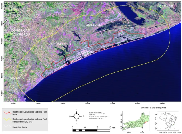
Vegetation cover and land use of a protected coastal area and its surroundings, southeast Brazil
Texto
Imagem

Documentos relacionados
Between the years 2004 and 2010 (Figure 4), an increase was noticed in forest areas, mainly where there was already an increase of deforestation and forest areas, in some cells
In the Machadinho d’Oeste study area, the 2001 Landsat ETM image was used to conduct land use/ cover classification, consisting of 12
Com o objetivo de descrever um fenômeno específico, a fim de traçar um perfil do que é, porque, como e quando ocorre, na intenção de solucionar problemáticas no cuidado em saúde,
O texto busca refletir sobre a emergência daquele que é considerado o sentido moderno do conceito de Revolução, tendo como objetivo a discussão da trajetória que passa do
The proposed model of two professionalism models (Evetts, 2010, p.130): organ- isational-based professionalism and occupational-based professionalism in knowledge societies is
Se os computadores e a internet são, hoje em dia, considerados ferramentas fundamentais para o estudo, o desempenho de uma profissão e mesmo para o exercício
Para identificar em qual ano os domicílios brasileiros chegariam à marca de 50% ou mais com a presença da Internet, foi realizada uma projeção populacional
