Research Note
Comparing webshare services to assess mountain bike use in protected
areas
Maria B. Campelo
a,n, Ricardo M. Nogueira Mendes
baFaculdade de Ciências da Universidade de Lisboa, Departamento de Biologia Animal, Campo Grande, 1749-016 Lisboa, Portugal
bCentro Interdisciplinar de Ciências Sociais, Faculdade de Ciências Socias e Humanas, Universidade Nova de Lisboa, Av. De Berna 26 C, 1069-061
Lisboa, Portugal
a r t i c l e
i n f o
Article history:
Received 21 June 2015 Received in revised form 5 August 2016 Accepted 5 August 2016
Keywords:
Mountain biking Protected areas Webshare services GPS tracks Monitoring
a b s t r a c t
Mountain biking is increasing within protected areas worldwide with social and environmental impacts. Monitoring recreational activities can be difficult, but nowadays massification of GPS use and track's sharing can provide new tools to help do so, lower resource consumption. This study compares GPSies. com and Wikiloc.com to evaluate the similarity between both, as data sources’and if this information can be used to spatialize and measure use intensity of mountain biking in Sintra-Cascais Natural Park's (PNSC), Portugal. Virtually all mountain biking GPS tracks available for Sintra and Cascais area of PNSC were downloaded, rasterized and analyzed using GIS software. Although GPSies provided almost twice the amount of tracks and was proved to be the best webshare service for PNSC's mountain biking, overall results from using either one of those services were similar. Results and Conclusions reveal that vo-luntarily given data can be adequate and should be used to monitor recreational activities within re-creational and protected areas, and webshare services are a valid data source for such studies.
M a n a g e m e n t
i m p l i c a t i o n s
The increasing use of protected areas for recreational activities requires better and faster monitoring technics to help park managers deal with, and avoid, unwanted impacts. Previous work showed that GPS tracks voluntarily uploaded or created in sport dedicated webshare services might be a good information source to spatialize recreational activities. This study compares data from two webshare services, GPSies. com and Wikiloc.com, regarding mountain biking in Sintra-Cascais Natural Park (PNSC). Although the amount of data for PNSC's from both services is different, similar results can be drawn, providing quality information for monitoring purposes, on a low human and time resources budget. Crossing that in-formation with road networks, habitat charts, among others can help park managers to identify where unwanted conflicts and impacts are more likely to occur. This approach can provide support to park authorities’decisions and actions for the sustainable use of recreational activities within protected areas.
&2016 Elsevier Ltd. All rights reserved.
1. Introduction
Protected areas’(PAs) main objective is to protect nature and cultural heritage, while allowing people its use for recreation and tourism (Cesseford & Muhar, 2003;Wolf et al., 2014). One way to achieve this goal is to monitor visitors, providing essential in-formation for decision making. This could contribute to promote PA's sustainable use supported by good recreation planning and management while guaranteeing a good recreational experience
(Cessford, Cockburn & Douglas, 2002; Kajala et al., 2007). Espe-cially on PAs nearby big cities, due to their importance for city dwellers’well-being (Kajala et al., 2007), the pressure and stress are not limited to weekends or particular seasons (Arnberger & Brandenburg, 2002). This pressure is also intensified by the growing number of people looking for PAs for an increased num-ber of activities (Buckley, 2003).
Recent studies have addressed the importance of using remote monitoring technologies (Eagles, 2014) like GPS (Wolf, Hagenloh, & Croft, 2012), and public participation for gathering geographic information (Wolf et al., 2014). These allow monitoring a large number of visitors, to collect data on their number and spatial distribution, that otherwise would be harder to obtain and further away from the truth (Eagles, 2014). It also helps to manage social Contents lists available atScienceDirect
journal homepage:www.elsevier.com/locate/jort
Journal of Outdoor Recreation and Tourism
http://dx.doi.org/10.1016/j.jort.2016.08.001 2213-0780/&2016 Elsevier Ltd. All rights reserved.
n
Corresponding author.
conflicts’(Wolf et al., 2014) and create use maps that can be useful for environmental monitoring campaigns, especially in PAs where use intensity varies in a small area (Wolf et al., 2012). When GPSies was tested as a tool to monitor mountain biking (MTB) in Arrá-bida's Natural Park (PNArr), Portugal, creating a realistic MTB
spatialization without the need for many resources (Nogueira
Mendes et al., 2012), it proved to be a promising method. One of the increasingly popular activities in PAs worldwide is MTB (Wolf et al., 2014). It helps improving physical health, social cohesion and connection to nature but it also has environmental and social impacts (Wolf et al., 2014). MTB is a social activity (Taylor, 2014;Wolf et al., 2014) and its practice increases alongside technological advances, allowing mountain bikers to reach places where they could not go before, posing a management problem (Chavez, Winter, & Bass, 1993). For these reasons, there have been many recreational ecology studies on this subject. Environmental impacts, according toMarion and Wimpey (2007),Pickering, Rossi, & Barros (2011), fall upon vegetation, soil and fauna. Many impacts are related to trail construction (Marion & Wimpey, 2007; Bal-lantyne, Gudes, & Pickering 2014) and Technical Trail Features (Leung et al., 2014; Kollar, 2011). Other issues include informal trails and habitat fragmentation (Ballantyne, Gudes, & Pickering,
2014), but with good management and correct usage can be
sub-stantially avoided (Marion & Wimpey, 2007) and will not be bigger than hikers’or horse riders’(Marion & Wimpey, 2007;Thurston & Reader 2001), although often times their tracks are longer than other users’(Arnberger & Hinterberger, 2003). Safety issues have
also been addressed due to the idea that bikers are safety hazards, even thoughCessford (2003)has found that hikers that encounter bikers along the trails are not less satisfied with their experience. Like other recreational activities mountain biking has also be-come another motive for social networking. Dedicated local or national web forums, blogs and Facebook are nowadays com-pletely connected through dedicated apps like Endomondo, GPSies, MapMyRide, Runtastic, Sports-tracker, Strava, Wikiloc. It is becoming easier, cheaper and more common for joggers, bikers, etc. to record their tracks and share them in sport dedicated webgis services and sites. GPS Loggers and smartphones equipped with assisted GPS make movement data easily accessible and a resource that can be uploaded and managed in online services (Garbe, 2010). Depending on the website characteristics, tracks can be available for free download by anyone.
After thefirst analysis using GPSies’datasets to spatialize MTB in PNArr (Nogueira Mendes et al., 2012,2014), we now use Por-tuguese Sintra-Cascais Natural Park (PNSC) MTB to compare dif-ferent webshare services’ability to create a reliable spatialization of recreational activities and provide useful information to park managers. Knowing in advance that the use of these apps and webshare services, like in any other social media on the web, depend on popularity among users, popular apps/websigs in one place or region may be of no use on any other place. Thus this type of comparison test becomes useful in terms of management for recreational and PAs.
2. Methods
2.1. Study site
The PNSC (Fig. 1) is located within Sintra and Cascais munici-palities, in Lisbon's Metropolitan Area, which has 2.8 M in-habitants. Created in 1994 and being part of the National Network of Protected Areas, it is one of the Portuguese PAs closest to the Portuguese capital and the one with the highest resident density and visitor's number all year round. With 14,583 ha and maximum altitude of 528 m, it has a wide variety of ecosystems, some with high value, included in Natura 2000 Network. Sintra Village and the surrounding areas are classified as UNESCO's World Heritage under the Cultural Landscape category (Baltazar & Martins, 2005). This PA is one of the two in Portugal that owns a Nature Sports Chart (CDN) which regulates recreational and sports activities in-side the park. Published in 2008 and currently being revised, it allows for a series of activities, as Hiking, Climbing, Horse Riding, Mountain biking, Speleology, etc. For MTB, it allows competition or recreational use, in pathways and forest roads, offering 7 cross country individual and circular trails, ranging from 15 km to 25 km (Fig. 1) (Regulamento da Carta de Desporto de Natureza do Parque Natural de Sintra-Cascais de 18 Janeiro, 2008).
Mountain bikers’of PNSC were profiled within a field survey
dedicated to this activity in 2014/15 (Campelo, 2015). Results have shown that the average biker is 30–54 year old, married men and mostly living within the park municipalities or surrounding ones. Most ride in the park once or twice a week, in groups of 2–5 bikers, and although mainly on Sunday mornings, MTB is an activity that runs all week, day and night. Users think of themselves as ex-perienced mountain bikers and invest a significant amount of money in this sport. For these users, mountain biking is both a training and social event. Most PNSC's mountain bikers upload their tracks onto webshare services such as GPSies, Endomondo, Strava and Wikiloc (Campelo, 2015).
Despite the CDN, all involved stakeholders (park managers and local authorities, mountain bikers, dwellers and other users) ac-knowledge that the number of MTB users is very high and that the amount of trails used is much higher than the official offer, in-cluding not only pathways and forest roads but also informal or illegal trails. Such use produces several conflicts and sometimes excessive behaviors, with trespassing being one of the most critical.
2.2. Web share data gathering and analysis
Among the several webshare services (webgis services that enable data sharing) available nowadays, GPSies.com and Wikiloc. com are two of the oldest ones, created in 2006 and holding 3.9 M and 4.8 M tracks respectively (by August 2016). GPSies runs on Leaflet (an open-source JavaScript library for mobile-friendly in-teractive maps) and Wikiloc runs with Google since 2008. Both services offer live track can run off-line trough dedicated apps for Android and IOS devices.
In early 2015 GPSies had 2,801,207 tracks, with a total 452,105,234 km, available worldwide. Of these, 229,014,549 km were marked by their uploader as bicycle suitable (GPSies 2015). By March 2015 Portugal had 99,650 submitted tracks and 66,804 tracks available for download guaranteeing the 7th place in the top countries with the most available tracks, ahead of United King-dom, Belgium or Switzerland (GPSies 2015). For Wikiloc the cor-responding information is not available with the same detail, but by the end of 2015 it held 4.0 M, double of the tracks held by April 2014 (Wikiloc, 2016).
In order to compare GPSies and Wikiloc information on MTB activity within PNSC, queries were made to both services using
Sintra, Cascais and MTB as search criteria. A search radius of 5 km was also used in GPSies. Other popular and more recent webshare services like Endomondo, Strava, MapMyRide, Runtastic, Sports-tracker were not used since those do not allow for massive download of tracks. Being more recent and following the current trends on many other social media and web services, the ability to share (i.e. download) GPS tracks is restricted among registered friends.
GPSies queries can provide up to 250 tracks by query that can be downloaded in .gpx, .kml, and .kmz formats. Wikiloc limits the download to a few .gpx tracks per user/day, which required tracks to be downloaded during several days in order to have a com-parable dataset. To avoid any discrepancies due to different data gathering periods, only tracks that were available on October 9th, 2013, when the GPSies queries were downloaded, were used.
Tracks in .gpx were later converted into shapefiles using QGis 2.0 and then Imported to an ArcGIS 10.0 project. Duplicate tracks from both queries (Sintra and Cascais) for Wikiloc and GPsies were deleted andfinal datasets were plotted against PNSC limits. Fol-lowingNogueira Mendes et al. (2012), afishnet grid of 50 m was used to retrieve use intensity within the park by counting the number of tracks that crossed each cell. Final grids for each dataset were rasterized with the same pixel size in order compare both datasets.
Thefirst comparison was done in terms of“use”/”no use”of each grid, after a binary reclassification of each dataset. ArcGIS raster calculator was used to perform this analysis (GPSies binary raster was subtracted by Wikiloc) resulting in a quality information map of MTB use on each data source were differences among GPSies and Wikiloc tracks were highlighted.
A second analysis was made in order to compare relative use intensity of each cell among each dataset. Original raster datasets for each webshare service were reclassified in 10 quantiles of equal intervals for use intensities between 1 and the maximum number of tracks. One extra category was defined to include cells with no use, i.e. were no MTB tracks have been recorded in order to keep this information available for the analysis. New raster datasets were compared with combine tool from spatial analyst extension for ArcGIS 10.0, resulting in 40 output classes according to the unique combination of input values (0–10 for each dataset), per-forming the comparison in terms of quality and quantity of information.
3. Results and analysis
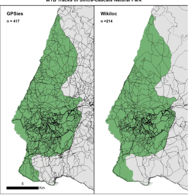
As shown inTable 1, GPSies generated more data than Wikiloc (417 vs 214 tracks) with an average of 42 and 40 km per track
respectively. Average km/track were also in line with Campelo
(2015)that addressed a deepest analysis on GPSies that covered the entire area o PNSC with 8 more queries with a 5 km search radius, gathering 1998 tracks with an average of 41 km in length. For Arrábida Natural Park a PA also within Lisbon metropolitan area,Nogueira Mendes et al. (2014), found 2 432 tracks with an average 47.7 km submitted from October 2006 to April 2014 to GPSies. The fact that the amount of information on GPSies was higher than Wikiloc might be justified by the fact that this
Table 1
GPSies and Wikiloc datasets concerning number of tracks, total km, and km/track.
GPSies SintraþCascais Wikiloc SintraþCascais
Number of tracks 417 214
km 17,676 8467
webshare service is older than Wikiloc and well spread among the
biker's community in Portugal. On a preliminary field survey in
2014 with 146 answers’in PNSC (Campelo, 2015), 60% of the bikers acknowledge to record and to upload their MTB rides to these webshare services. While Strava was the most used service, GPsies was 3 times more used than Wikiloc.
For both services, results show a clear difference between the official offer of park's CDN MTB trails (Fig. 1) and trails being used (Fig. 2). Despite the apparent differences, both services present MTB as an activity occurring in the entire area of the park, but with a clear core area, i.e. more concentration around SintraSerra–
the Cultural Landscape of Sintra and Roca cape. On a first
ap-proach, the difference between track numbers on each dataset doesn’t seem to be crucial in terms of MTB use in the study area. Fig. 3presents use intensity for both datasets. Again it reveals a similar distribution of mountain biking along the PNSC territory with GPSies providing more detail in areas of the park with less use.
Table 2shows the results obtained from the raster calculator.
87% of the cells, whether they are “use” or “no use”, include
equivalent information on both datasets (differences are of about 10% of the cells used just by GPSies and 3% of the cells used just by Wikiloc). Even being GPSies an older webshare service, and with more submitted tracks for the study area, the systematic search on other services such as Wikiloc can highlight relevant results (Fig. 3).
The reclassification of both dataset'sfishnet grid in 10 quantiles (Fig. 4) not only supported thefinding of a similar distribution of use intensity along the territory, but also a similar relative dis-tribution of the number of cells per quantile. Over 82% of the 60,626 cells of PNSCfishnet grid reveal the exact same information (concerning the use/no use, but also concerning the relative use intensity) on both datasets. Even so, there are some differences that could be important in terms of the park management.
Sintra UNESCO heritage site) that gives access to some of the most famous MTB downhill/freeride trails of Sintra likeDimas,Pontes,
Monge and Kamikaze, and where there is also a small parking
space.
4. Discussion
Nowadays’ massification of GPS access and use of tools and
Web 2.0 technology, where users are able to alter and participate in the content, like Wikipedia, OpenStreetMap, transformed the
sports’ dedicated webshare services in a useful tool for PAs’
managers. One major advantage of gathering data this way is the
low resource consumption. The acquired data can provide im-portant information on the territory's use and help describing the users’ profile (Garbe, 2010; Nogueira Mendes et al., 2014) and preferences. Information from webshare services is voluntarily made public by the users, meaning that gathering it doesn’t cross ethical boundaries, such as privacy issues. As referred byWood, Guerry, Silver, and Lacayo (2013)crowd-sourced information can be a reliably proxy for empirical visitation rates.
Both data sources (GPSies and Wikiloc) proved to be a fair re-presentation of MTB's spatialization in Sintra-Cascais Natural Park. Both showed a dense web of trails being used, showing the in-efficiency of CDN's offer in response to this activity's pressure and users expectations. Some trails are informal/illegal, opened by mountain bikers without a proper permit like those used for downhill/freeride which is a banned activity within Park. Inter-secting these spatialization maps with land record´s datasets, of-ficial road networks and habitat charts can be used by park
managers tofind where trespassing occurs, where informal or
il-legal trails exist and were environmental impacts might happen, respectively.
All stakeholders acknowledge the need for management mea-sures in order to reduce MTB social and environmental impacts in PNSC. These services can therefore be a valid method to help managers to monitor this PA's MTB. Since it has a higher amount of data GPSies provided a higher resolution and almost all trails and paths used for MTB found on Wikiloc are also present on GPSies. The number of Km/ track found in both datasets being so similar, also supports the data similarity. Analysis of the results from the Fig. 3.Use intensity of the MTB tracks from GPSies and Wikiloc datasets and differences in relative territory use by each dataset.
Table 2
Quality comparison on use/no use between data gathered on mountain biking from GPSies and Wikiloc for Sintra-Cascais Natural Park. Results were obtained by sub-tracting Wikiloc from GPSies binary raster on ArcGIS 10.0 raster calculator from spatial analyst extension.
GPSies – Wikiloc Result Grids No. Grids (%) Interpretation
1 – 0 1 6 186 10 Use exclusively within
GPSies dataset
1 – 1 0 52,698 87 Identical use within
GPSies & Wikiloc datasets
0 – 0
0 – 1 1 1 742 3 Use exclusively within
fishnet grid, raster calculator and combine tool support these findings.
5. Conclusions
Sport dedicated webshare services can be a valid, important
and cheap tool for PAs’managers, who so many times have few
resources at their disposal, by providing useful and important in-formation to help monitor and manage recreational activities in PAs. Because this information is made public by the users them-selves, there is no risk of crossing ethical boundaries. Using these services can help managers and researchers to spatialize and to infer use intensity of recreational activities. It can highlights areas
of potential conflicts between users, activities and stakeholders or
it could help to define monitoring campaigns andfield surveys.
Future studies could test the validity of this approach within other PAs or recreational activities, exploring other results that could be retrieved from webshare services as datasources. Any limitations of this research can be overcome with counters on trails to confirm use intensity results. In addition, comprehensive studies on the webshare services user's profiles should validate these as a proper sample of the entire practitioner's population.
Acknowledgments
This research note presents research results of the
Interdisciplinary Centre of Social Sciences – CICS.NOVA– FCSH/ UNL Project (UID/SOC/04647/2013) funded by the Portuguese State Budget through the Fundação para a Ciência e Tecnologia.
References
Arnberger, A., & Brandenburg, C. (2002). Visitor structure of a heavily used con-servation area: The Danube Floodplains national park, lower Austria. In Arn-berger, A., Brandenburg, C., & Muhar, A. (Eds.)Proceedings of the 1st interna-tional conference on monitoring and management of visitorflows in recreational and protected areas(pp. 7–13).
Arnberger, A., & Hinterberger, B. (2003). Visitor monitoring methods for managing public use pressures in the Danube Floodplains National Park, Austria.Journal for Nature Conservation,11, 260–267.
Ballantyne, M., Gudes, O., & Pickering, C. (2014). Recreational trails are an important cause of fragmentation in endangered urban forests: A case-study from Aus-tralia.Journal of Landscape and Urban Planning,130, 112–124.
Baltazar, L., & Martins, C. (2005). Atlas do Parque Natural Sintra-Cascais, sinta a natureza. Junta de Turismo da costa do Estoril e Parque Nacional de Sintra-Cascais.
Buckley, R. (2003). Ecological indicators of tourist impacts in parks.Journal of Ecotourism,2(1), 54–66.
Campelo, M. (2015). Caraterização do BTT no Parque Natural de Sintra-Cascais. Um contributo para a revisão da Carta de Desporto de Natureza. M.Sc. thesis. Lis-bon: University of Lisbon.
Cessford, G. (2003). Perception and reality of conflict: Walkers and mountain bikes on the Queen Charlotte Track in New Zealand.Journal for Nature Conservation,
11, 310–316.
Cessford, G., Cockburn, S., & Douglas, M. (2002). Developing new visitor counters and their applications for management. In Arnberger, A., Brandenburg, C. & Muhar, A. (Eds.)Proceedings of the 1st international conference on monitoring and management of visitorflows in recreational and protected areas(pp. 14–20). Cesseford, G., & Muhar, A. (2003). Monitoring options for visitor numbers in
na-tional parks and natural areas.Journal for Nature Conservation,11, 240–250. Chavez, D., Winter, P., & Bass, J. (1993). Recreational mountain biking: A
manage-ment perspective.Journal of Park and Recreation Administration,11(3), 29–36. Eagles, P. (2014). Research priorities in park tourism.Journal of Sustainable Tourism,
22(4), 528–549 doi:10.108009669582.2013.785554.
Garbe, M. (2010). Online location data: Analysis of publicly available trajectory data sources. In Cap, C. (Ed.)Baltic conference, learning in networks(pp. 45–52) [GPSies] (2015)
http://www.gpsies.com/home.do?langua-ge¼pt#10_38.75970458984375_ 9.239700317382812_mapQuest. (Last ac-cess 13.03.15).
Kajala, L., Almik, A., Dahl, R., Dikšaitè, L., Erkkonen, J., Fredman, P.,…Wallsten, P. (2007).Visitor monitoring in nature areas–A manual based on experiences from
the Nordic and Baltic countries. 19–30. Stockholm: Swedish Environmental Protection Agency.
Kollar, C. (2011). Characterizing mountain biking use and biophysical impacts through technical trail features: A case-study of a montane and costal plain site in the USA. MSs thesis. Raleigh, NC: North Carolina State University. Leung, Y.-F., Ruschkwski, Ev., Pickering, C., Mendes, R. M. N., & Kollar, C. (2014).
Assessing technical trail features for mountain biking: Examples from four countries. In Reimann, M., Sepp, K., Parna, E., & Tuula, R. (Eds.)Proceedings of the 7th international conference on monitoring and management of visitors in re-creational and protected areas(pp. 166–168). ISBN: 978-9949-29-166-3. Marion, J. & Wimpey, J., (2007). Environmental impacts of mountain biking: Science
review and best practices. InManaging mountain biking, IMBA's guide to pro-viding great riding(pp. 94–111). Boulder: International Mountain Bicycling As-sociation (IMBA).
Nogueira Mendes, R., Silva, A., Grilo, C., Rosalino, L., & Silva, C. (2012). MTB mon-itoring in Arrábida Natural Park, Portugal. In Fredman, P., et al. (Eds.) Proceed-ings of the 6th international conference on monitoring and management of visitors in recreational and protected areas(pp. 32, 33). ISBN: 978-1-908272-66-9, ISSN: 2048-8912.
Nogueira Mendes, R., Dias, P., & Silva, C. (2014). Profiling MTB users’preferences within protected areas through WebShare services. In Reimann, M., Sepp, K., Parna, E., & Tuula, R. (Eds.)Proceedings of the 7th international conference on monitoring and management of visitors in recreational and protected areas(pp. 166–168). ISBN: 978-9949-29-166-3.
Pickering, C. M., Rossi, S., & Barros, A. (2011). Assessing the impacts of mountain biking and hiking on subalpine grassland in Australia using an experimental protocol.Journal of Environmental Management,92(2011), 3049–3057.http://dx. doi.org/10.1016/j.jenvman.2011.07.016.
Regulamento da Carta de Desporto de Natureza do Parque Natural de Sintra-Cas-cais. 1ª série, n°13, 18 de Janeiro de 2008. Capítulo II.
Taylor, S. (2014). Understanding mountain bikers’choices of recreational settings. In Reimann, M., Sepp, K., Parna, E., & Tuula, R. (Eds.)Proceedings of the 7th international conference on monitoring and management of visitors in recreational and protected areas(pp. 132–133). ISBN: 978-9949-29-166-3.
Thurston, E., & Reader, J. (2001). Impacts of experimentally applied mountain biking and hiking on vegetation and soil of a deciduous forest.Environmental Management,27(3), 397–409.http://dx.doi.org/10.1007/s002670010157. Wikiloc (2016).〈http://pt.wikiloc.com/wikiloc/about-us.do#history〉(Last access In
03.08.2016).
Wolf, I. D., Hagenloh, G., & Croft, D. B. (2012). Visitor monitoring along roads and hiking trails: How to determine usage levels in tourist sites.Tourism Manage-ment,33, 16–28.http://dx.doi.org/10.1016/j.tourman.2011.01.019.
Wolf, I., Wohlfart, T., Brown, G., Lasa, A., & Torland, M. (2014). Monitoring and management of mountain biking through public participation geographic in-formation systems. In Reimann, M., Sepp, K., Parna, E., & Tuula, R. (Eds.) Pro-ceedings of the 7th international conference on monitoring and management of visitors in recreational and protected areas(pp. 158–160). ISBN: 978-9949-29-166-3.