i
Universidade Nova de Lisboa Lisboa, Portugal
User Generated spatial Content sources for Land
Use/Land Cover validation purposes: suitability
analysis and integration model
A thesis submitted in partial fulfillment of the requirements for the degree of Doctor of Philosophy in Information Systems
Specialization in Geographic Information Systems by
Jacinto Paulo Simões Estima
Supervisor Marco Painho, PhD
ii Copyright by Jacinto Estima
June 2015
No part of this thesis may be reproduced by any means without the author’s permission.
iii
Traditional geographic information has been produced by mapping agencies and corporations, using high skilled people as well as expensive precision equipment and procedures, in a very costly approach. The production of land use and land cover databases are just one example of such traditional approach. On the other side, The amount of Geographic Information created and shared by citizens through the Web has been increasing exponentially during the last decade, resulting from the emergence and popularization of technologies such as the Web 2.0, cloud computing, GPS, smart phones, among others. Such comprehensive amount of free geographic data might have valuable information to extract and thus opening great possibilities to improve significantly the production of land use and land cover databases.
In this thesis we explored the feasibility of using geographic data from different user generated spatial content initiatives in the process of land use and land cover database production. Data from Panoramio, Flickr and OpenStreetMap were explored in terms of their spatial and temporal distribution, and their distribution over the different land use and land cover classes. We then proposed a conceptual model to integrate data from suitable user generated spatial content initiatives based on identified dissimilarities among a comprehensive list of initiatives. Finally we developed a prototype implementing the proposed integration model, which was then validated by using the prototype to solve four identified use cases.
iv
value but should be integrated to increase their potential. The possibility of integrating data from such initiatives in an integration model was proved. Using the developed prototype, the relevance of the integration model was also demonstrated for different use cases.
Keywords
Land Use / Land Cover, Geographic Information Systems, User Generated Spatial Content, Integration Model, Spatial Data Integration
v
Informação geográfica tem sido tradicionalmente produzida por agências de mapeamento e corporações, através de pessoas altamente qualificadas, bem como equipamentos de precisão e procedimentos dispendiosos, numa abordagem bastante onerosa. A produção de bases de dados de uso e cobertura do solo são apenas um exemplo da referida abordagem. Por outro lado, a quantidade de informação geográfica criada e partilhada pelos cidadãos através da Web tem vindo a aumentar exponencialmente durante a última década, resultante do surgimento e popularização de tecnologias como a Web 2.0, computação na nuvem, GPS, telefones inteligentes, entre outros. Esta quantidade de dados geográficos livres pode ter informações valiosas para extrair e assim abrir a possibilidade de melhorar significativamente a produção de bases de dados de uso e cobertura do solo.
Nesta tese explorou-se a viabilidade da utilização de dados geográficos, de diferentes iniciativas de conteúdo espacial gerado por utilizadores, no processo de produção de bases de dados de uso e cobertura do solo. Dados das iniciativas Panoramio, Flickr e OpenStreetMap foram explorados em termos de sua distribuição temporal e espacial, e da sua distribuição pelas diferentes classes de uso e cobertura do solo. Foi de seguida proposto um modelo conceptual para integrar dados de iniciativas de conteúdo espacial gerado por utilizadores baseado nas diferenças identificadas de entre uma lista abrangente de iniciativas. Finalmente, desenvolveu-se um protótipo de implementação do modelo proposto, o qual foi
vi identificados.
Concluiu-se que os dados de iniciativas de conteúdo espacial gerado por utilizadores tem um grande valor, mas devem ser integrados para aumentar o seu potencial. A possibilidade de integração de dados de diferentes iniciativas num modelo de integração foi provada. Através do protótipo desenvolvido, foi também demonstrada a relevância do modelo de integração em diferentes casos de uso.
Palavras-chave
Uso e Cobertura do Solo, Sistemas de Informação Geográfica, Conteúdo Espacial Gerado por Utilizadores, Modelo de Integração, Integração de Dados Espaciais
vii
List of peer-reviewed publications resulting from this thesis so far:
Jacinto Estima and Marco Painho (2015) Investigating the Potential of OpenStreetMap for Land Use/Land Cover Production: A Case Study for Continental Portugal. In: Jokar Arsanjani, J., Zipf, A., Mooney, P., Helbich, M., OpenStreetMap in GIScience: experiences, research, applications. ISBN:978-3-319-14279-1, PP. 273-293, Springer Press.
Jacinto Estima and Marco Painho (2014) Photo Based Volunteered Geographic Information Initiatives: A Comparative Study of their Suitability for Helping Quality Control of Corine Land Cover. International Journal of Agricultural and Environmental Information Systems 5(3): 75-92. doi: 10.4018/ijaeis.2014070105.
Jacinto Estima, Cidália Fonte and Marco Painho (2014) Comparative study of Land Use/Cover classification using Flickr photos, satellite imagery and Corine Land Cover database. Proceedings of the AGILE’2014 International Conference on Geographic Information Science, Castellón, June, 3-6, 2014. ISBN: 978-90-816960-4-3.
Jacinto Estima and Marco Painho (2013) Exploratory analysis of OpenStreetMap for land use classification. 2nd ACM SIGSPATIAL International Workshop on Crowdsourced and Volunteered Geographic Information (GEOCROWD) 2013. 5 – 8 November 2013. Orlando, Florida, USA. doi: 10.1145/2534732.2534734.
viii
Photos: Preliminary Study of Its Adequacy for Helping Quality Control of Corine Land Cover. In Computational Science and Its Applications–ICCSA 2013 (pp. 205-220). Springer Berlin Heidelberg. doi: 10.1007/978-3-642-39649-6_15.
ix
Despite having the final responsibility of the work presented in this thesis, it would not be possible without the contribution of many persons to whom I would like to express my gratitude:
First and foremost I would like to express my gratitude to my adviser Professor Marco Painho. I am grateful for the guidance, support, patience and friendship. The work presented in this thesis would not be possible without his availability, continuous support and encouragement. I hope that our collaboration may continue for many years. I am also grateful for giving me the possibility to participate in the COST Action TD1202 – Mapping and the citizen sensor – funded by the European Union.
A special thanks to my friend and PhD colleague António José Silva for our discussions. They helped me a lot in developing the initial research idea. A big thanks to my friend Luis Calisto for the fruitful discussions we had especially during the phase of the prototype development. A special thanks to Professor Hosni Ghedira, Director of the Research Center for Renewable Energy Mapping and Assessment at the Masdar Institute of Science and Technology, Abu Dhabi, UAE, for his continuous encouragement and also for allowing me to continue this study in parallel with my main job there for the last three years.
Finally to my family and friends for their continuous support. To my wife Ana Cristina Estima for all the patience, love and encouragement throughout this journey. To my
x
xi
AA Accuracy Assessment
AGI Ambient Geographic Information API Application Programming Interface CASA Centre for Advanced Spatial Analysis GI Geographic Information
GE Google Earth
GPS Global Positioning System
LC Land Cover
LU Land Use
LULC Land Use / Land Cover
NCGIA National Center for Geographic Information and Analysis
OSM OpenStreetMap
PFM Public Facility Management SOA Service-Oriented Architecture
SOA-SDI Service-Oriented Architecture for Spatial Data Integration SR2S Safe Route-to-School
UGC User Generated Content
xii
VGI Volunteered Geographic Information
xiii
1. INTRODUCTION ...1
2. STATE OF ART ...9
3. FEASIBILITY OF USER GENERATED SPATIAL CONTENT FOR LAND USE/LAND COVER . 37
4. USER GENERATED SPATIAL CONTENT-INTEGRATOR MODEL ... 91
5. PROTOTYPE DEVELOPMENT AND IMPLEMENTATION ... 120
xiv
ABSTRACT ... III
KEYWORDS ... IV
RESUMO ... V
PALAVRAS-CHAVE ... VI
LIST OF PUBLICATIONS ... VII
ACKNOWLEDGEMENTS ... IX
LIST OF ABBREVIATIONS ... XI
SHORT INDEX ... XIII
INDEX ... XIV
LIST OF FIGURES ... XVIII
LIST OF TABLES ... XXI
1. INTRODUCTION ...1
1.1. IDENTIFICATION AND CONTEXTUALIZATION OF THE PROBLEM ... 2
1.2. RESEARCH OBJECTIVES ... 4
1.3. IMPORTANCE AND RELEVANCE OF RESEARCH ... 4
1.4. METHODOLOGY ... 5
1.5. THESIS ORGANIZATION ... 7
xv
2.2. USER GENERATED SPATIAL CONTENT ... 10
2.2.1. Definitions ... 10
2.2.2. Relevance ... 11
2.2.3. Historical overview ... 13
2.2.4. UGsC challenges and issues ... 18
2.3. LAND USE/COVER DATA ... 19
2.3.1. Land use/cover production ... 19
2.4. UGSC AND LAND COVER MAPPING ... 21
2.5. SPATIAL DATA INTEGRATION ... 28
2.5.1. Interoperability ... 30
2.5.2. Distributed GIS ... 31
2.5.3. Data harmonization, conflation and fusion ... 33
2.6. CONCEPTUAL FRAMEWORK... 34
2.7. DISCUSSION AND CONCLUSIONS ... 35
3. FEASIBILITY OF USER GENERATED SPATIAL CONTENT FOR LAND USE/LAND COVER . 37 3.1. INTRODUCTION ... 37
3.2. THE OPENSTREETMAP INITIATIVE ... 41
3.2.1. Exploratory analysis of OpenStreetMap for land use classification ... 42
3.2.2. Investigating the Potential of OpenStreetMap for Land Use/Land Cover Production: A Case Study for Continental Portugal ... 53
xvi
adequacy for helping quality control of Corine Land Cover ... 61
3.3.2. Comparative study of Land Use/Cover classification using Flickr photos, satellite imagery and Corine Land Cover database ... 72
3.3.3. Photo based UGsC initiatives: a comparative study of their suitability for helping quality control of Corine Land Cover ... 77
3.4. CONCLUSION ... 89
4. USER GENERATED SPATIAL CONTENT-INTEGRATOR MODEL ... 91
4.1. INTRODUCTION ... 91
4.2. SOURCES OF USER GENERATED SPATIAL CONTENT ... 92
4.2.1. Description of the selected UGsC initiatives ... 97
4.2.2. Structural similarities and dissimilarities among the selected initiatives ... 111
4.3. USER GENERATED SPATIAL CONTENT-INTEGRATOR ... 113
4.3.1. Virtual versus materialized integration approach ... 113
4.3.2. Model architecture ... 114
4.4. CONCLUSION ... 119
5. PROTOTYPE DEVELOPMENT AND IMPLEMENTATION ... 120
5.1. INTRODUCTION ... 120
5.2. DEFINING THE USE CASES ... 121
5.2.1. Photo interpretation use case ... 123
5.2.2. Cartography validation use case ... 124
xvii
5.3. ARCHITECTURE AND IMPLEMENTATION ... 127
5.4. SOLVING THE USE CASES ... 133
5.4.1. Photo interpretation use case ... 133
5.4.2. Cartography validation use case ... 137
5.4.3. Landscape architecture use case ... 144
5.4.4. Programmer use case ... 146
5.5. CONCLUSION ... 148
6. CONCLUSION, CONTRIBUTIONS AND FUTURE DIRECTIONS ... 149
6.1. SUMMARY ... 149
6.2. DISCUSSION OF HYPOTHESES ... 151
6.3. MAIN CONTRIBUTIONS TO THE SCIENTIFIC COMMUNITY ... 152
6.4. LIMITATIONS ... 153
6.5. FUTURE WORK ... 154
REFERENCES ... 156
APPENDIXES ... 166
APPENDIX 1 – VGI INITIATIVES BY ELWOOD ET AL. ... 167
APPENDIX 2 – INVENTORIED VGI INITIATIVES ... 170
xviii
Figure 1 - Thesis methodology ... 6
Figure 2 - Millions of photos uploaded per month – Jan. 2004 to Dec. 2012 ... 17
Figure 3 - Conceptual framework ... 35
Figure 4 - High-level global methodology ... 40
Figure 5 - Spatial distribution of OSM classified areas over continental Portugal (left) and Distribution of classes’ coverage areas by continental Portuguese districts (right) ... 53
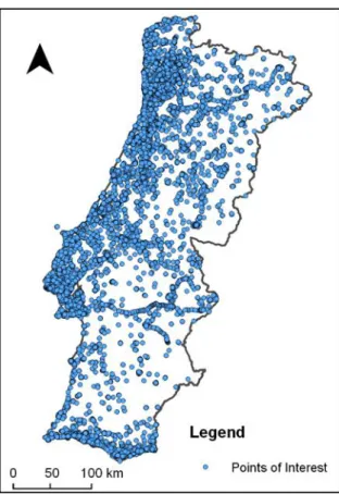
Figure 6 - Spatial distribution of the points of interest over the study area ... 57
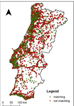
Figure 7 - PoI type class vs. CLC class ... 59
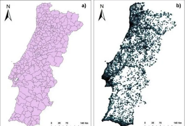
Figure 8 - a) Portuguese boundaries and b) distribution ... 63
Figure 9 - Number of photos per year (left); monthly average of photos between 2004 and 2012 (right). ... 65
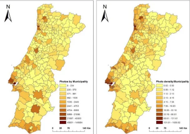
Figure 10 - Flickr photos frequency distribution by municipalities: absolute number of photos (left) and normalized by area (right) ... 66
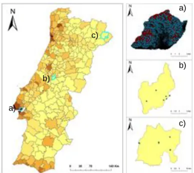
Figure 11 - Spatial distribution of Flickr photos over the municipalities of Lisboa (a), Pedrógão Grande (b) and Vimioso (c) ... 67
Figure 12 - Monthly distribution of photos in each CLC level 1 class ... 70
Figure 13 - Monthly variation of photos by district ... 70
Figure 14 - CLC level 1 classes in Coimbra municipality (left) and Location of the sample Flickr photos used for the analysis (right) ... 73
Figure 15 – Photo datasets used: a) Flickr photos’ locations, and b) Panoramio photos’ locations ... 79
xix
2004 and 2012 ... 81
Figure 17 - Spatial distribution of photos density: a) Flickr photos density b) Panoramio photos density and c) Flickr (yellow) vs. Panoramio (green). ... 84
Figure 18 - Monthly distribution of photos in each CLC level 1 class ... 87
Figure 19 - Density of photos from both initiatives by district and CLC level 1 class 89 Figure 20 - Degree confluence project website ... 98
Figure 21 - Online map of the Flickr initiative ... 101
Figure 22 - OpenStreetMap online map ... 103
Figure 23 - GeographUK initiative website ... 104
Figure 24 - Panoramio online map ... 106
Figure 25 - Wikimapia online map ... 107
Figure 26 - Twitter timeline website ... 109
Figure 27 - Instagram website ... 110
Figure 28 - Data integration by location ... 112
Figure 29 - High level architecture ... 114
Figure 30 – Data integration model architecture ... 115
Figure 31 – Detail of the mediator tier ... 118
Figure 32 - Integrated view of the four identified use cases ... 122
Figure 33 - Photo-interpreter use case diagram ... 123
Figure 34 - Cartography validator use case diagram ... 125
Figure 35 - Landscape architect use case diagram... 126
Figure 36 - Programmer use case diagram ... 127
xx
Figure 39 - Final layout (features dashboard) ... 132
Figure 40 - Initial map for the photo interpretation use case ... 134
Figure 41 - Features dashboard for the photo interpretation use case ... 137
Figure 42 - Initial map for the cartography validation use case ... 138
Figure 43 - Features dashboard for the cartography validation use case ... 140
Figure 44 - Detail of the Features info view for an OSM selected feature ... 141
Figure 45 - Selecting features by tag with multiple tags selected ... 141
Figure 46 - Detail of the Tag statistics view ... 142
Figure 47 - Main map view with a dropped overlaying polygon ... 143
Figure 48 - Initial map for the landscape architect use case ... 145
Figure 49 - Features dashboard for the landscape architect use case ... 145
Figure 50 - Initial map for the programmer use case ... 147
xxi
Table 1. Inventory of VGI Initiatives in 2009 ... 14
Table 2 - List of studies undertaken to explore the suitability of UGsC initiatives for the purpose of helping LULC activities... 38
Table 3 - CLC nomenclature and respective areas for continental Portugal ... 39
Table 4 - OSM datasets' classes over continental Portugal ... 43
Table 5 - Areas of coverage of the used OSM datasets ... 45
Table 6 - Existing classification differences within the three OSM datasets ... 47
Table 7 - Correspondence between CLC and OSM classes ... 48
Table 8 - Coverage areas from CLC level 1 and OSM ... 50
Table 9 - Confusion matrix of CLC vs. OSM classifications ... 51
Table 10 - Classification accuracy ... 52
Table 11 - List of types of OSM PoIs ... 56
Table 12 - CLC classes given to each PoI type ... 58
Table 13 - Classification of OSM points ... 60
Table 14 - Classification accuracy by PoI type ... 61
Table 15 - Density of Flickr photos by level 1 classes of CLC ... 69
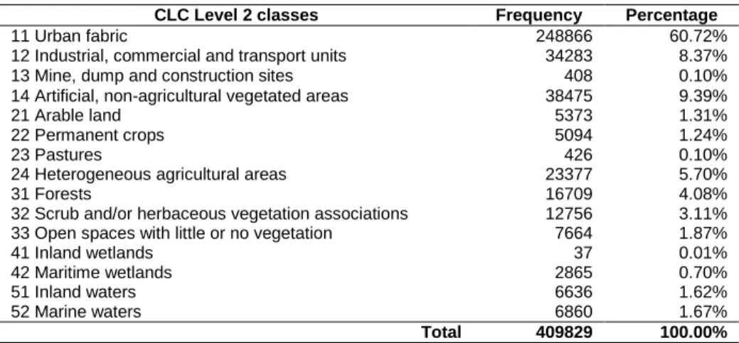
Table 16 - Frequency of Flickr photos by level 2 classes of CLC ... 69
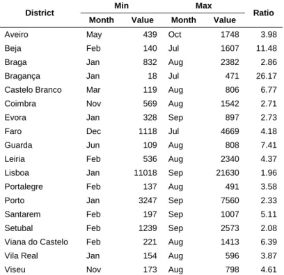
Table 17 - Minimum and Maximum values, respective months and ratio of photos by district ... 71
Table 18 - Summary of Flickr photos ... 73
Table 19 - Classification of Flickr photos ... 75
xxii
Table 22 - Density of Flickr and Panoramio photos by level 1 classes of CLC ... 85 Table 23 - Number and distribution of photos by CLC level 2 classes ... 86 Table 24 - Min and Max values, respective months and ratio of photos by district ... 88 Table 25 - List of essencial requirements that any initiative must have ... 96 Table 26 – Selected UGsC initiatives ... 96 Table 27 - Important elements from a request response from Flickr ... 102 Table 28 - Important elements from a request response from Panoramio ... 106 Table 29 - Main elements on a search response from the Wikimapia API ... 108
1
1. Introduction
In the last years, the amount of Geographic Information (GI) created and shared by citizens through the Web has been increasing exponentially. The emergence and popularization of some technologies ‒ Web 2.0, cloud computing, GPS, smart phones, among others ‒ have transformed, and still are, the way how geographic data are produced, stored and used (Sui, Goodchild, & Elwood, 2013). The literature shows that research has been conducted trying to explore the enormous potential that this type of data seems to be hiding and find possibilities of using it in the solution of real world problems (e.g.: Estima & Painho, 2013a; Goodchild & Glennon, 2010; Hollenstein & Purves, 2010; Mooney, Corcoran, & Winstanley, 2010; Pultar, Raubal, Cova, & Goodchild, 2009; See et al., 2013; Zook, Graham, Shelton, & Gorman, 2010).
2
One important area where this data sources could be very helpful is in the Land Use/Cover (LULC) database production. In this matter, interesting results have already been accomplished (J Jokar Arsanjani, Helbich, & Bakillah, 2013; Jamal Jokar Arsanjani, Helbich, Bakillah, Hagenauer, & Zipf, 2013; Estima, Fonte, & Painho, 2014; Estima & Painho, 2013a, 2013b, 2014, 2015; Fonte, Bastin, See, Foody, & Lupia, 2015; Foody & Boyd, 2013a, 2013b; Foody, 2010; Fritz et al., 2012, 2009; Hagenauer & Helbich, 2012; Jamal Jokar Arsanjani, Helbich, Bakillah, Hagenauer, & Zipf, 2013; Jamal Jokar Arsanjani & Vaz, 2015; Perger et al., 2012). Nevertheless, the literature also shows important gaps providing us with an excellent opportunity to contribute to this interesting topic. Some particularities of this type of data, described later in this document, make their use very challenging and therefore this study is designed to explore different sources of User Generated spatial Content (UGsC) and develop a data model able to integrate them so they can be used to help in the production of LULC databases.
1.1. Identification and contextualization of the problem
GI has been produced by mapping agencies and corporations and sold to users as paper maps or atlases (Goodchild & Glennon, 2010). This approach is very expensive since it requires expert people as well as expensive precision equipment and procedures. Consequently priority is given to the most important and unchanging geographic themes and those with multiple applications relegating the other ones for a second plan (Goodchild, 2008).
One of those examples are the LULC databases that play a very important role in a vast number of research fields (Caetano, Mata, & Freire, 2006; Fritz et al., 2009; Herold, 2009). Its production is mainly based on interpretation and classification of remote
3
sensing data, made by highly trained and skilled people (Herold, 2009) and goes through a phase process since the planning and data acquisition, pre-processing, analysis/classification, to the final product and documentation (J. Cihlar, 2000). Although all the phases are very important, the validation phase has a particular and very important goal: to provide the final product with quality indicators to those who want to use it. This validation is made by confronting the produced cartography with reference information assumed as true, that includes, among other sources, “ground truth” collected directly from the filed in pre-selected sites (Caetano et al., 2006). This in situ ground measurements acquisition represents a major limitation caused by its high cost, both in terms of money and time (Strahler et al., 2006).
On the other hand, since 2005, with the introduction of the Web 2.0, the spatial data produced by citizens became exponentially available over the Web. This is due not only to the increasing availability of positioning equipment’s at a lower cost, better and free imagery of the world, among others, but also to the willingness of private citizens to contribute for several reasons (Elwood, Goodchild, & Sui, 2012; Heipke, 2010).
The amount of produced data is of very different nature and one of the most important characteristics is the local knowledge of its contributors that know their surroundings better than any outsider (Heipke, 2010). The availability of this quantity of data provides us with a great opportunity to explore new ways to use it for helping LULC production. While the major advantages are associated with its quantity, temporal coverage and size (Leung & Newsam, 2010), this big quantity of data is very heterogeneous and scattered over different projects with completely different data structures, making its integration consequently very difficult.
4
1.2. Research objectives
Considering the problem stated in the previous section, the aim of this work is to explore the suitability of data from different UGsC initiatives with different formats and structures to be used in the production of LULC databases, and propose a data model to integrate these data from different sources and structures. The motivation for this main objective is related with the following research questions:
1. Are the data from UGsC initiatives feasible to help in the production of LULC databases?
2. Which types of geographic data from UGsC initiatives are more suitable to use in the production of LULC databases?
3. Is it possible to integrate these data in a common data model/platform?
1.3. Importance and relevance of research
The exponential availability of geographic data from diverse UGsC initiatives in the last few years has increased the motivation of the research community to explore their potential and usefulness in the solution of real world problems.
Two main strategies have been followed and examples are provided in chapter 2: 1) to ask volunteers to explicitly contribute to specific projects or 2) to explore data already available in different UGsC initiatives. The first strategy needs volunteers to be available and willing to contribute while the second explores existing data already contributed to other initiatives for different purposes. Experiments using the first approach are described in section 2.4 (Clark & Aide, 2011; Fritz et al., 2009).
5
Focusing on the second strategy, more connected with this study, the literature shows that research already conducted only uses data from one or two different UGsC initiatives (Arsanjani et al., 2013; Hollenstein & Purves, 2010; Kisilevich, Krstajic, Keim, Andrienko, & Andrienko, 2010; Leung & Newsam, 2010; Zielstra & Hochmair, 2013; Zook et al., 2010). Therefore there is no research related with the integration of data from different UGsC sources with diverse structures for the purpose of helping the LULC databases production process.
As already stated before in this document, the major advantages of contributed data are associated with its quantity, temporal coverage and size (Leung & Newsam, 2010) but the fact that it is scattered over several different projects represents a major limitation. This study attempts to bridge the gap and contribute to the scientific community by exploring the suitability of different UGsC initiatives for LULC database production and proposing a data model for the integration of these data from different sources and structures. This data model will indirectly contribute to the cost and time reduction of the LULC production and will also increase even further the value of this type of data.
1.4. Methodology
The approach followed in this thesis is shown in Figure 1.
The first part was to perform an in depth study of the literature in terms of UGsC initiatives. As previously mentioned, UGsC initiatives have been growing in the last years and so the number of research projects trying to explore them in the solution real world problems. We looked at the literature and an in depth review, with a particular focus on the use of UGsC for the specific application on LULC databases production, is
6
presented. This review allowed us to understand what has been already studied and identify existing gaps that could be explored.
We then conducted a preliminary analysis of the feasibility of some of the most well-known UGsC initiatives to be used in the process of LULC databases production. We explored their spatial and temporal distribution as well as their matching rate against an official and validated LULC database. These analyzes allowed us to understand how suitable these sources of spatial data are and identify already advantages and challenges of using them for LULC database production.
The following part was to develop an integration model to integrate data from different UGsC initiatives. To develop such a model as comprehensive as possible, it was very important to take into account the LULC needs and also the characteristics of available
7
and suitable UGsC initiatives. Therefore, taking into account these LULC needs, the first step was to discuss the requirements that any dataset would need to be used for the purpose of helping in LULC database production, leading to the definition of a set of minimum requirements. Then a comprehensive list of UGsC initiatives was developed and a subset following these minimum requirements was extracted and their structural dissimilarities analyzed. The integration model was then developed taking into account these dissimilarities.
To assess the developed model, a prototype was then developed and implemented, in this last part of the methodology. We started the development of the prototype by defining its requirements. To do so we identified and analyzed a set of four use cases reflecting four potential users of the model and prototype. The next step was to develop the prototype based on the defined requirements and use it to solve the defined use cases and thus validate the model. This validation was of extreme importance to test not only the model but also to demonstrate its usefulness.
1.5. Thesis organization
This thesis is organized as follows.
Chapter 1 introduces the research topic of this study. It starts by identifying and contextualizing the research problem followed by the definition of the research objectives and a discussion on the importance and relevance of the study. The chapter ends with the description of the methodology and the organization of the thesis.
Chapter 2 presents an in depth review of the literature related with UGsC. First a definition is provided followed by the description of UGsC initiatives already explored for
8
different applications. A revision of the LULC databases production process is also provided followed by the description of studies already conducted to use data from UGsC initiatives for LULC related matters.
Chapter 3 describes a set of preliminary studies on the use of data from different UGsC sources to help in the process of LULC database production. Different sources of UGsC were used to explore their suitability to be used in the production of LULC databases.
Chapter 4 presents a data model that integrates different sources of UGsC to help in the process of LULC databases production. A list of UGsC sources that follow a set of defined minimum requirements is provided and their structural dissimilarities discussed. The model is then developed based on these dissimilarities.
Chapter 5 describes the development of a prototype implementing the proposed integration model. It starts by identifying four use cases to define the system requirements based on which the prototype was developed. The prototype was then used to solved those use cases and thus validate the model.
Chapter 6 summarizes the conclusion of this research. The drawn hypotheses are discussed and the main contributions to the scientific community presented, followed by the discussion of some limitations of this study as well as the identification of future research directions.
9
2. State of art
2.1. Introduction
In this chapter we review the different definitions associated with GI produced by citizens and explore some of the most well-known related initiatives reported and studied in the literature. We then analyze the production of LULC databases and discuss the work already conducted using this type of UGsC data in their context. We finish debating spatial data integration as well as the concepts and methods involved.
10
2.2. User Generated spatial Content
2.2.1. Definitions
In 2007, Goodchild coined the term Volunteered Geographic Information (VGI) to describe “the widespread engagement of large numbers of private citizens, often with little in the way of formal qualifications, in the creation of geographic information, a function that for centuries has been reserved to official agencies.” (Goodchild, 2007). One year before in 2006, Neogeography was introduced by Turner as a term to describe the phenomenon of “...people using and creating their own maps, on their own terms and by combining elements of an existing toolset, ...sharing location information with friends and visitors, helping shape context, and conveying understanding through knowledge of place.” (Turner, 2006). Crowdsourcing geospatial data is another term used to describe the phenomenon of large unorganized groups of users generating content (spatial in this case) that is shared (Hudson-Smith, Batty, Crooks, & Milton, 2009).
Despite some differences between these terminologies (Elwood et al., 2012), they are all related with a type of User Generated Content (UGC) that deals directly or indirectly with spatial content and refers to volunteers and large groups of people, sometimes acting like a crowd, often without expertise or formal qualifications, contributing with spatial data to the “community”, a function that for centuries has been reserved exclusively to official agencies (Goodchild, 2007).
More recently, Stefanidis et. al (2011) came up with what they defined as a “deviation from Goodchild’s notion of volunteered geography” (p. 319). They argue that the
11
information disseminated through some social media initiatives is not geographic information per se, e.g. geography is not their main purpose, unlike other initiatives such as OpenStreetMap, although they provide a geographic context since they have associated information about location. They called it Ambient Geospatial Information (AGI).
Also Fischer (2012) argued that, in some cases, when VGI is used for different purposes than those for which volunteers have contributed, it can be seen as a not-so-Volunteered Geographic Information and had termed this as involuntary geographic information (iVGI).
We are introducing here a new term, called User Generated spatial Content (UGsC) to integrate all the previous definitions. Moreover, this term is a particular case of UGC that deals with spatial content, and is intended to encompass all the initiatives containing data with spatial characteristics provided by citizens with or without the purpose of contributing data for spatial purposes, such as VGI, iVGI, neogeography, crowdsourcing geospatial data and AGI.
2.2.2. Relevance
The relevance of the topic has been proved by the growing number of meetings and workshops held in recent years. The first of its kind happened in December 2007 held in Santa Barbara, CA, organized by the National Center for Geographic Information and Analysis (NCGIA), Los Alamos National Laboratory, the Army Research Office and The
12
Vespucci Initiative where some important topics were discussed and some position papers published1.
The United States Geological Survey (USGS) organized, in 2010, a workshop on Volunteered Geographic Information, held in Herndon, VA, resulting in a set of publically available presentations and breakout session minutes2 documenting the activities.
VGI workshops have been also offered by several conferences on GIS Science. The International Conference on Advances in Geographic Information Systems (ACM SIGSPATIAL), the AGILE Conference on Geographic Information Science or the International Conference on Geographic Information Science (GISience) are just a few examples.
More recently, an initial training network, called “geocrowd”, funded under an FP7 - People Marie Curie Actions by the European Commission, was launched aiming at “establishing a fertile research environment by means of a training network that will promote the GeoWeb 2.0 vision and advance the state of the art in collecting, storing, analyzing, processing, reconciling, and making large amounts of semantically rich user-generated geospatial information available on the Web”3. Other two projects under the
European Cooperation in Science and Technology (COST) framework were funded by the European Union: 1) the COST action IC12034 - European Network Exploring
Research into Geospatial Information Crowdsourcing: software and methodologies for
1 The position papers are available at http://ncgia.ucsb.edu/projects/vgi/participants.html 2 Available at http://cegis.usgs.gov/vgi/results.html
3 Extracted from http://www.geocrowd.eu/
13
harnessing geographic information from the crowd (ENERGIC) and 2) the COST action TD12025 - Mapping and the citizen sensor.
All these research initiatives and activities demonstrate not only the interest of the research community but also how relevant this topic is to the research agenda.
2.2.3. Historical overview
The participation and contribution of citizens in this filed is not new. Various examples are documented like teachers and school children contributed to land use surveys of Britain in the 1930s, or the urban residents involved in the Bunge's “Geographical Expeditions” in 1971 (Elwood et al., 2012). Another interesting initiative, that started around 1999 and is still currently active, is the portal established by the USGS Earthquake Hazards Program for earthquake mapping called ‘‘Did you feel it?’’ (http://earthquake.usgs.gov/earthquakes/dyfi/) where people affected by earthquakes could provide information about their experiences regarding its position in the geographical space (Heipke, 2010).
The turning point for an exponential growth of volunteer’s participation occurred in 2005 with the development and introduction of Google Maps and its Application Programming Interface (API). This aligned with the Web 2.0 technology have made a revolution providing users with the possibility of embedding their own varieties of Google Map’s in their web pages (Batty, Hudson-Smith, Milton, & Crooks, 2010), and along with the availability of cheaper positioning devices combined with camera and mobile or smart phones, fine resolution-imagery, broad band communications, among other
14
improvements, empowered citizens to produce and share their own maps (Elwood et al., 2012; Heipke, 2010).
After Google Maps and the Web 2.0, several VGI projects started and have been contributing since then to the increasingly amount of available spatial data over the Web that exists nowadays. In 2009, an inventory made by Elwood et al. (Elwood et al., 2012) counted ninety-nine VGI initiatives, 70 percent of them started after 2005 against 20 percent that took place before that (Table 1). One of the first initiatives still active, based on Google Maps is Wikimapia (http://wikimapia.org), where people with an Internet connection can select any place in the world map and provide its description along with its boundaries, under the motto “Let’s describe the whole world”. Its philosophy is adapted from the successful Wikipedia project, where anyone can contribute with content, and a group of volunteers monitor the results checking for accuracy and significance (Goodchild, 2007).
Table 1. Inventory of VGI Initiatives in 20096
Date initiated Percentage
Pre - 2000 6%
2000 - 2004 14%
2005 - 2009 73%
Unable to identify 7%
OpenStreetMap (OSM, http://www.openstreetmap.org/) is another well-known VGI project developed by the OpenStreetMap Foundation that aims at providing free geographic data, such as street maps, to anyone. Users collect data (including topographic data) mostly with GPS or GPS enabled equipment, upload it to the OSM Web page, and complete it with descriptions, names and other attributes. The data is
15
then available to anyone in the form of render maps and other services, including the possibility to download it in vector format (Elwood et al., 2012).
On 6th March 2005, the Geograph initiative launched the Geograph website that aimed to collect and publish online, at least one representative photograph (geograph) per grid square for Great Britain and Ireland. By the end of March, 1 thousand photos had already been uploaded. Since then, the number of submitted photography’s has been increasing significantly. One million images by October 2008, two million by August 2010, three million by the end of June 2012 and four million in early June 2014 (Geograph, 2012). Data from this initiative as well as data from the Flickr initiative were used by Leung and Newsam (2010) to derive maps from what-is-where from large collections of georeferenced photo collections. According to the authors, photos from the Geograph initiative were more accurate than those from the Flickr initiative because their contributors were contributing with the specific intention of geo-visually annotate Great Britain and Ireland.
In 2007, Google launched MyMaps, allowing users to create lines and shapes, embedding text, photos and videos with a simple drag and drop interface, based on Google Maps. Hudson-Smith et al. (Hudson-Smith, Crooks, Gibin, Milton, & Batty, 2009) argue that this was probably one of the most important innovations in mapping since the development of GIS. The Centre for Advanced Spatial Analysis (CASA) has also developed a set of tools allowing the non-professional user to integrate their data. Google Map Creator (GMapCreator) enables users to simplify thematic mapping in Google Maps. The London Profiler website (http://www.londonprofiler.org/) is a resource where public data from the public domain can be displayed over Google Maps and GmapCreator and it plays an important role in preparing the thematic maps for
16
displaying. Another tool developed by CASA is a ”place to put maps” called Map Tube (http://www.maptube.org/), where users can share information in the way of thematic maps produced with the GmapCreator, and based on the generic idea of YouTube (Hudson-Smith, Crooks, et al., 2009).
However, there are initiatives of a different kind with citizens playing a more passive role in terms of contributing with geographic information. In these initiatives, although data has not been contributed with the specific purpose of extracting geographic information, certain spatial characteristics, such as the geographic location of features or assets, are present. We classify these initiatives as a type of UGsC initiatives.
The name Flickr it is today well known in the Internet world. It is an initiative started in 2004 described as an online application that aims at “…help people make their photos available to the people who matter to them” and “…enable new ways of organizing photos and video”7. Flickr photos are stored in databases along with some additional
information in the form of tags. Some information is automatically saved (e.g., contributing user, image metadata, and time of upload) and some other is introduced optionally by the user (e.g., title, caption, user restrictions, and a set of textual tags that best describes the photo). Spatial references can also be saved with the photo in the form of a special geotag that stores latitude and longitude (Hollenstein & Purves, 2010). Figure 2 shows that the number publically available Flickr photos has been increasing over the years and in 2012 where uploaded about 40 million of photos per month.
Some of these photos have latitude and longitude tag values which means that they are geo-referenced or “geotagged”. There is no available information on how many of these photos are geotagged but in 2010, Kisilevich et al. (Kisilevich et al., 2010) downloaded a
17
total of 86,314,466 entries of geotagged Flickr photos to study peoples’ activities using geotagged photo collections. This number is a very good demonstrator of the potential these resources may hide.
Figure 2 - Millions of photos uploaded per month – Jan. 2004 to Dec. 20128
Started in 2006, Twitter is a very well-known online initiative that allows users to create and share ideas and information instantly using short messages with a maximum of 140 characters (Twitter, 2014). The added value of such short messages is related with the possibility of carrying location information and also the real-time nature of each tweet (message). This has been especially important for disaster detection, communication and response (Adam & Muraki, 2011; Funayama, Yamamoto, Tomita, Uchida, & Kajita, 2014; Mills & Chen, 2009; Sakaki, Okazaki, & Matsuo, 2010; Spence, Lachlan, Lin, & del Greco, 2015), but also for other applications such as political elections (Reips & Garaizar, 2011; Tsou et al., 2013), crime (Gerber, 2014), health (Signorini, Segre, & Polgreen, 2011), just to name a few.
In the private sector domain, the HD TrafficTM initiative from TomTom (http://www.tomtom.com/en_gb/services/live/hd-traffic/) aims at providing instant information about traffic to its customers, based on data collected from car drivers phones and can be regarded as a crowdsourcing system, where the crowd is part of the
18
group of passive mappers (Heipke, 2010). Another interesting initiative, a real-world outdoor treasure hunting game, is the Geocaching game (http://www.geocaching.com/), where Players try to locate hidden containers, called geocaches, using GPS-enabled devices and then share their experiences and photographs in the website with other geocachers. The location of the geocachers is presented in a map based on Google Maps.
2.2.4. UGsC challenges and issues
The interesting and important initiatives presented in the previous section are only a part of the most well-known VGI initiatives and prove the exponential growth of spatial data availability over the web, but further research in the GIScience domain is needed to maximize their potential. How can we integrate this kind of data with authoritative data to fill gaps in spatial data infrastructure augmenting, updating, or completing it (Elwood, 2008a; Goodchild & Glennon, 2010; Heipke, 2010; Sui & Goodchild, 2011). Are the existing structures and practices for spatial data collection, retrieval, validation, and dissemination appropriate in this new context (Elwood, 2008b)? What types of geographic information are the most suited for acquisition through the efforts of volunteers (Goodchild & Glennon, 2010)?
Cowen, in the position paper presented at the VGI Workshop introduced some existing initiatives involving private citizens contributing to national mapping mostly from private agencies (Cowen, 2007). Google Inc. has enlisted private citizens in India to create content for Google Map products, and has also formed a business relationship with states in Australia to provide parcel level geocoding across the country. Governmental agencies should conduct such a practice by themselves.
19
These questions are a small set of issues related with the acquisition, integration and management of spatial data, but there are much more already formulated by the research community regarding data quality, legal and ethical issues, the digital divide, social impacts, among many other (Elwood et al., 2012; Elwood, 2008a; Goodchild & Glennon, 2010; Goodchild, 2007; Heipke, 2010; Kuhn, 2007; Sui, 2007, 2008).
2.3. Land Use/Cover data
Cihlar and Jansen (Josef Cihlar & Jansen, 2001) referred Baudiles and Szejwach in their paper to describe that Land Cover (LC) and Land Use (LU) are two key elements that represents respectively natural and human-related environments. LC attempts to characterize the biophysical features while LU is more related with the human interaction with these natural features. Despite some differences, both are related with characterization of land that plays a very important role in a vast number of research fields, such as LULC monitoring and modeling, monitoring of tropical deforestation, climate changes, among others, at both global, regional and local scales (Caetano et al., 2006; Fritz et al., 2009). Its production is mainly based on interpretation and classification of remote sensing data, made by highly trained and skilled people.
2.3.1. Land use/cover production
According to Cihlar (J. Cihlar, 2000) LULC production from satellite data consists of four main steps: data acquisition, pre-processing, analysis/classification, and product generation and documentation. Data acquisition is related with the acquisition of remote sensing data used as the base for the classification process. The pre-processing phase deals with a way to present the data in a proper format to extract information.
20
Analysis/classification is related with the extraction and classification process while the product generation and documentation deals with the final steps in the conclusion of the final product as well as its appropriate documentation.
The analysis/classification phase, beyond the analysis/classification itself must end with the validation, so called Accuracy Assessment (AA). This is a very important task and it aims to offer map quality indicators in order to provide the cartography with a degree of confidence to those who wants to use it. This AA is made by confronting the produced cartography with reference information assumed as true such as aerial photography; satellite imagery with better resolution than those used in production; and field work (M. Caetano et al., 2006). Magnussen, referred by Cihlar (J. Cihlar, 2000), states that the AA needs to contain “ground truth” as part of the sampling design. This field work increases the cost and the time consumption of the LULC production and can easily become unfeasible.
Due to these cost and time constrains, LULC databases are usually more focused on the most important themes and those with multiple applications, leaving behind those considered “less important”. The time between updates or new productions is also a critical factor, but once more, as a consequence of production costs, it is stretched and the databases become outdated quickly (Goodchild, 2008).
Cihlar (J. Cihlar, 2000) concluded in his paper that “The research agenda needs to address the best ways of taking advantage of the new capabilities and, importantly, the ways of resolving problems identified during the production of the land cover maps over large areas”. Therefore, VGI initiatives should be investigated to evaluate their adequacy in the LULC production processes.
21
2.4. UGsC and Land Cover mapping
As stated before, VGI has been increasingly used to research novel applications for different areas, including LULC database production. In this particular domain two different approaches have been used so far: 1) asking volunteers to actively contribute to a specific project such as the validation of global land cover datasets (Fritz et al., 2009; Perger et al., 2012) , and 2) using data contributed for other purposes/projects to extract valuable information and develop new ways to use it in this domain (Estima & Painho, 2013a, 2013b, 2014).
Geo-Wiki.Org (Fritz et al., 2009) is a project that fits in the first approach, described as a global network of volunteers who wish to help improve the quality of global land cover maps. “GLC-2000”, “MODIS”, and “GlobCover” global land cover databases are overlaid on a platform based on Google Earth (GE) and their areas of divergence highlighted. Then, a network of registered volunteers helps to solve these discrepancies using their local knowledge along with available GE satellite imagery and other ancillary data coming from other VGI projects such as pictures from Panoramio (http://www.panoramio.com/) and Degrees of Confluence Project (http://www.confluence.org/).
Another example is the Virtual Interpretation of Earth Web-Interface Tool (VIEW-IT) initiative based on GE high-resolution imagery to collect LULC reference data (Clark & Aide, 2011). It was tested with a small group of selected users acting as volunteers and not yet in a real crowdsourcing environment. Nevertheless they found important issues with using GE and its satellite imagery, e.g. the legal restrictions in the free use of the
22
Google Maps/Earth APIs and that some classes that cannot be discriminated with the available imagery (e.g. different annual crops).
In these examples, volunteers need to be available to contribute to these specific projects and they also need to have some familiarity with these tools, which might be discouraging for some groups of participants. To overcome this difficulty, some projects occasionally use contests and a mechanism of rewards to increase contributions and participation (Fritz et al., 2012; Perger et al., 2012).
Using the second aforementioned approach, some experiments were conducted by Leung and Newsam (2010) to derive maps of what-is-where from large collections of georeferenced photos in an automated way. In this initial work the authors derived LC classifications from georeferenced image collections for locations where ground-truth was available. The aim was to evaluate the quality of the results obtained from the automatic classification by comparing them with the available ground truth. They achieved a classification accuracy of approximately 75%.
Another interesting work was conducted by Estima and Painho (2013b) to explore the possibility of using Flickr photos as a source of ground-truth data to help in the accuracy assessment phase of LULC production. Using continental Portugal as the study area and CORINE (coordination of information on the environment) Land Cover (CLC) as a reference LULC database, the authors explored all the publically available and geotagged Flickr photos in terms of their temporal and spatial distributions and their distribution over the different CLC classes. The number of photos and their temporal resolution were the most positive aspects whereas their asymmetry and irregular distribution over different CLC classes the most negative. They concluded stating that
23
this could be a valuable source of ground truth data if combined with other sources but could not be used alone.
Foody and Boyd (2013) used two sources of volunteered data to illustrate the potential of amateur or neogeographical activity in map validation. They used photographs acquired from an internet-based collaborative project and interpreted by other volunteers to evaluate the Globcover map’s representation of tropical forests in West Africa. They confirmed the potential value of VGI projects, such as the Degrees of Confluence project, for the provision of useful, spatially extensive, data to support map evaluation.
As already mentioned, the OSM initiative is one of the most well-known and studied VGI initiatives in the literature. The research that has been conducted to use data from the OSM initiative for LULC mapping purposes is quite extensive.
The possibility of using VGI data to replace training data acquired from in-site visits in the process of LULC classification was investigated by Arsanjani, Helbich and Bakillah (2013). Using the city of Koblenz, Germany, as the study area, they applied a supervised classification approach to classify data from the RapidEye sensor, and they used data downloaded from the OSM project as field measurements to select the most optimal training sites. They performed a comparison of the resultant LU map with the Global Monitoring for Environment and Security Urban Atlas (GMESUA) map achieving a Kappa index of 89%, which proves that OSM data is suitable to use as a source for training site definition. They also stress that the quality of VGI is heterogeneous and location-dependent, and they recommend checking the amount of contributions and also considering other VGI data, such as Flickr photos.
24
Another study investigated a new approach to generating land-use patterns from VGI without applying remote-sensing techniques and/or engaging official data (Jamal Jokar Arsanjani et al., 2013). Using OSM datasets and Vienna, Austria, as the study area, the authors applied a Hierarchical GIS-based decision tree approach to classify and segment parcels. The results were evaluated by conducting a texture-variability analysis of the LU maps generated using each dataset, and producing a confusion matrix to compare each LU class in the two datasets. Results of the texture analysis showed that the LU patterns derived from OSM data are richer than those derived from GMESUA. The confusion matrix showed a high level of agreement between the two classifications but this decreased when we move from level 1 towards the more detailed level 3. Although they conclude that VGI can be a potential data source for mapping LU patterns, they only used one source of VGI, OSM, and they did not test any other sources. Nevertheless, they pointed out as advantages of such an approach that no inputs from remote-sensing or any other administrative data were used, no financial cost exists as the OSM data is freely available and no field work was required, a number of incorrectly labeled features in the GMESUA were identified when OSM was incorporated, and the process of updating LU maps is facilitated due to the updating rate of OSM while GMESUA requires time and high financial costs to be updated by authorities.
A different approach was previously proposed by Hagenauer and Helbich (2012). They applied Artificial Neural Networks (ANNs) and Genetic Algorithms (GAs) as a machine learning methodology to delineate continuous urban areas using all the information diversity of OSM, where a large set of potential OSM at-tributes was derived for inductive learning. Using OSM and GMESUA data, they applied this methodology to 42 randomly selected GMESUA urban regions and analyzed the significance of the
25
attributes used and the performance of the mod-el. The model performed comparatively well for most regions, with a few remark-able exceptions. The study shows that if enough OSM data for reasoning is pre-sent, urban patterns can be predicted to a large extent. This approach could be very useful to help map continuous fabric classes, from OSM data, for LULC databases.
The representation of natural features in OSM was also explored by Mooney, Corcoran and Winstanley (2010), who examined the level of detail present in the representation of such polygon features. They tried to verify if there was enough detail in the representation of those features to provide a high-quality spatial representation. They used data for Austria, Estonia, Switzerland, Bretagne, Lower Saxony, Iceland, Ire-land, and Scotland to calculate the statistical distribution of the mean distance between connected vertices of polygons. They found that many of the features are under-represented, with a small number of vertices used to delineate them, while some of them might be considered over-represented (e.g. small urban green spaces and golf courses). Some OSM data collection characteristics, such as the different GIS skill levels of OSM volunteers or the differences in accuracy of equipment and methods used, influence the under-representation of some features. These under-represented features have a serious impact on using OSM data in certain Earth science applications, mainly those that use OSM as ground-truth data. They recommend that the quality of the OSM representation of “natural” polygons and other features should be established against a recognized ground-truth dataset.
In this sense, other authors have been exploring the quality of OSM data that are of interest for LULC database production. Barron, Neis and Zipf (2014) developed a comprehensive framework for intrinsic OSM quality analysis that included the logical
26
consistency of “natural” and “landuse” polygons. They developed a tool to generate information about OSM data quality for a selectable area without a reference dataset but using only OSM's data history. This tool intends to help users to assess the OSM data quality of a given area for a specific application. As an example, for map applications such as LULC database production, the tool automatically identifies erroneously overlapping land use polygons and analyzes not only the equidistance between the polygons’ adjacent vertices, which is a good way to determine the quality of those polygons, but also the evolution of their equidistance over time.
Methods to analyze the completeness of building footprints over space and time were described and analyzed by Hecht, Kunze and Hahmann (2013) for the German states of North Rhine-Westphalia and Saxony. They used unit-based and object-based methods to analyze the level of completeness of building footprints contained within OSM by always comparing them with a reference dataset regarded as complete. They conclude that unit-based methods require less computation but have limitations in their level of detail when compared with object-based methods. Their results in applying these methods to the mentioned areas of Germany showed that OSM building footprints, as of November 2012, are characterized by a low degree of completeness, below 30%, and a strong geometrical heterogeneity, and the level of completeness is higher in urban than in rural areas.
A similar study for the German city of Munich was developed by Fan, Zipf, Fu and Neis (2014). In this study the authors developed a quality assessment of building foot-print data, after they found that the number of buildings in OSM was over 77 mil-lion on 5 May 2013. Building footprints were assessed using four criteria: 1) completeness, 2) semantic accuracy, 3) position accuracy, and 4) shape accuracy, where OSM data were
27
compared with the reference data from the German Amtliches Topographisch-kartographisches Informatiosystem – Authorative Topographic-Cartographic Information System (ATKIS) to perform a quantitative assessment. They concluded that, for the case study of Munich (Germany), a high level of completeness was found but OSM building footprints still lack important attributes such as name, type, and height, among others. They found, however, more than 1200 newly constructed buildings which were not documented in the ATKIS data.
On the other side, although OSM building footprints are very similar in terms of shape, they have on average a 4 m offset to their corresponding ones in ATKIS in terms of position accuracy. Building footprints might be an important source of information to help in the classification or validation of urban areas, and these results are a very good indicator. Jokar Arsanjani and Vaz (2015) analyzed the completeness and thematic accuracy of seven European metropolises and thanks to the promising accuracy values concluded that these parameters greatly vary from location to location, which confirms the heterogeneity of contributions.
Building a hybrid land cover map with crowdsourcing and geographically weighted regression was the purpose of a recent study developed by See et al. (2014). The authors used medium resolution land cover products with crowdsourced data from the Geo-Wiki project combined by a geographically weighted regression approach to produce a hybrid global land cover map. They argued that the results serve to demonstrate that medium resolution global land cover information can be improved with existing products using spatial analysis methods.
28
Fonte, Bastin, See, Foody, & Lupia (2015) studied recently the usability of VGI for validation of land cover maps. They discuss potential and challenges of such type of data for land cover map validation based on a revision of cases where VGI data was used as an additional source of data to assist in map validation and also where only VGI data was used.
2.5. Spatial data integration
The debate about the diverse sources of geographic information we have been discussing in the previous sections drives us to discuss about another inevitable topic: the integration of such different sources and the benefits that might be obtained from their integration by exploiting the merits of each data source (Gösseln & Sester, 2004). Integrated analysis, geometric reference, mutual correction and refinements, semantic and geometric properties enrichment are among the benefits that might be obtained from the combination of different data sources (Butenuth et al., 2007).
However, the integration of data from heterogeneous sources brings up challenges that need to be overcome. Mohammadi, Rajabifard, & Williamson (2010) have identified technical and nontechnical issues related with the effective spatial integration using case studies from countries of the Asia-Pacific region. They propose an open web-based tool for the effective spatial data integration that facilitates data harmonization through the assessment of multisource spatial data sets against a set of defined rules where items of incompliancy are highlighted in a final report.
A 4-layered service-oriented architecture for spatial data integration (SOA-SDI) was proposed by Sha & Xie (2010) to build WebGIS applications. They argue that this
4-29
layered SOA-SDI shows more flexibility than the traditional service-oriented architecture (SOA) for building new GIS applications. For demonstration purposes and based on this infrastructure they have developed two WebGIS applications, Safe Route-to-School (SR2S) and Public Facility Management (PFM), based on four categories of data providers services: Google map, WMS services, ArcIMS services and Pictometry image service.
Although nontechnical aspects were identified in the paper of Mohammadi et al. (2010) more related with institutional, policy, legal and social aspects and therefore more connected with authoritative data sources, some technical issues were also acknowledged: inconsistent data specification; multiple raster and vector formats; variety of spatial resolution; different scales; differences in datum, projections, coordinate systems; data models; currency and accuracy; and logical inconsistency. These issues are part of what is called interoperability, a very important concept especially in distributed systems dealing with heterogeneous sources of data. Interoperability is seen as a solution to overcome syntactic, structural, and semantic differences among heterogeneous data sources at both spatial and temporal levels (Bishr, 1997; Brodeur, Bedard, Edwards, & Moulin, 2003; Laurini, 1998).
In the next sections we will describe and discuss the interoperability in 2.5.1 and discuss the integration problem in two dimensions: 1) the communicational dimension, and 2) the compatibility dimension. The first dimension refers to the communication and sharing of data among different sources of information and application interfaces, and is explored in section 2.5.2. The second dimension refers to the compatibility among data from heterogeneous sources and is described in section 2.5.3.