UNIVERSIDADE DE LISBOA
FACULDADE DE CIÊNCIAS
DEPARTAMENTO DE ENGENHARIA GEOGRÁFICA, GEOFÍSICA E ENERGIA
Post-rift magmatism on the Central West Iberian Margin
(Estremadura Spur): new evidences from potential field data
Cláudia Cristina Araújo Escada
Mestrado em Ciências Geofísicas
Especialização em Geofísica Interna
Dissertação orientada por:
Professor Doutor Fernando Acácio Monteiro dos Santos
Doutora Patrícia Machado Madureira Fontes Represas
To my Father, Rui.
In memory of my Grandmother, Salete.
Physicists believe that known laws should suffice to explain the Earth’s behaviour, but the complexities of geology have defied simple explanation. (John Tuzo Wilson, 1908-1993)
Acknowledgements
The path was long and made of ups and downs, but I must confess that it was the highs that define it, especially for the presence of all the people who surrounded me during this project. This thesis is also the beginning of my journey through the mysteries of geophysics. It’s a new world that I do not regret to know, and I want to continue exploring.
I must start by thanking my supervisors. To Professor Fernando Santos, due to his experience and genuine appreciation for geophysics which allowed me to learn a lot of the essential things for the execution of this thesis. To Patrícia Represas, who was always present to assist me in last minute geophysical doubts and, especially many (and many…) questions related to the software. Your knowledge enabled me to look at geophysics from another perspective. I could not have chosen better supervisors it was a great pleasure to work with both of them.
To Ricardo Pereira, although he is not one of my “official” supervisors, that’s how I saw him during this past year. I want to thank you for the hours of discussion that enabled me to think “outside the box” and understanding the theme of this thesis from a global perspective. I appreciate all the tireless corrections that have greatly improve the thesis.
I am grateful to Partex Oil and Gas for supporting this project, namely for financial support of my participation in the General Assembly EGU 2019, where it was presented a poster about the work developed in this thesis. I would like to thank Eng. Luis Guerreiro for making this possible.
To Pedro and Jennifer (plus Lucas, the fieldwork team!), for all the crazy talking and ideas during our long field days. Our idea was not forgotten, guys!
To the most powerful list of friends which I want to thank for all the fondness, concern and encouragement: Bibi, Carolina Marques, Daniela, Carolina, Margarida, Analdyne, Marta and, although the distance, to Sofia. Thank you for everything, girls!
To Tia Eugénia (and her famous chocolate salami!). To Vasco, for all the affection. And, not less important, to my Tia Zizinha, for all of her words.
To Alf (my cat…), for his unconditional love and company, always present during the long hours in front of the computer.
To my sister, Rita, for all of her patience during several weekends and to always cheer me up with board games, which we both love! To my mother, Cristina, who despite not being by my side, was always there for me to cheer me up with her good mood, positivism and contagious energy.
To Fábio, for being the most patient person in the world. Thanks for all of the conversations (even though he didn’t realize anything I was saying…). I am grateful for all of your support and for always be there for me in the good and bad times. Thank you for being who you are!
My biggest and most special thank you goes to my dad, Rui. From the very beginning, he was the foundation stone (here it comes the geology!) that gave me the strength, the courage and the confidence to move on. Thank you for showing me that everything is possible. Thank you for all the words of encouragement, not only through my academic life, but also throughout my life, and for all the support, not only financial, mas must importantly, emotional. Without you none of this would be possible, I am eternally grateful to you!
Lastly, I want to give a huge thank you to my grandmother, Salete, although she is no longer with us, I know that she guided me throughout this journey and was always by my side, and still is...
Abstract
Rifted continental margins are one of the most complex geological entities, being intensively studied not only from the academic point of view, but also for their economic importance, due to the occurrence of geological resources, from which oil and natural gas comprise the vast majority. Understanding the geological process that underpin the formation and evolution of these resources led academia and industry, to scrutinize this type of margins.
This study is grounded in recent advances in the knowledge of continental rifting and post-breakup of West Iberia, and in the discovery of an enigmatic geological feature located southwest of the Fontanelas volcano. This feature, whose nature and geometry are unknown, was identified based on new 3D seismic data offshore central Portugal, in the Estremadura Spur. Its seismic signature and similarity with the Sintra massif (shape and areal extent), suggest that it might correspond to a magmatic intrusion, with a batholith shape and granitic nature. This feature is described here for the first time therefore it was named as Estremadura Spur Intrusion (ESI).
This thesis proposes to characterise the geometry and nature of the Estremadura Spur Intrusion and the Fontanelas volcano, based on potential field data (i.e. gravity and magnetic) modelling supported and constrained by evidence from seismic profiles, and correlate the ESI with the Late Cretaceous post-rift magmatic event.
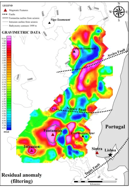
Firstly, a qualitative analysis of potential field data was performed based on signal enhancement techniques, focusing on the characterization of the main regional geological features, in order to frame the area under study. Overall, the gravity and magnetic anomaly associated with the ESI produces a nearly circular shape, confirming its outline from the 3D seismic data. On the other hand, the gravity anomaly of the Fontanelas volcano is more diffuse than the one from the ESI, while its magnetic anomaly it is much better constrained by an approximately circular geometry. Both targets have a strong geophysical signal, being distinguished from other regional features, indicating its importance on the West Iberian Margin and, more significantly, in the Estremadura Spur setting.
Subsequently, building on the regional interpretation, a more detailed analysis was performed through 2.5D modelling of potential field data, over a seismic line across the centre of the intrusion and the southeast flank of the Fontanelas volcano, with the aim to characterise both features, including their magmatic nature and geometry.
The Fontanelas volcano is characterised by an overall triangular shape, with a longer and deeper southern flank. This magmatic feature was subdivided into two segments: a seawater-rock contact zone and a buried zone, by Tertiary sediments. The density and susceptibility values determined for its buried sector (not in contact with the seawater) were interpreted as basalt. The lower density and susceptibility values associated with the seawater-Fontanelas contact zone are caused by the alteration of its original basaltic rock. This interpretation corroborates with the results of published work on the Fontanelas volcano.
Regarding the Estremadura Spur Intrusion, its geometry is interpreted as a laccolith (sheet-like magmatic structure). Although the conclusions regarding its magmatic affinities were not straightforward, the values of density and susceptibility obtained for this magmatic feature suggest the presence of a predominantly gabbroic intrusion, according to similarities, concerning its nature, with outcropping intrusions, such as Sintra and Sines massifs.
The seismic stratigraphic interpretation and the similarities between onshore (Sintra and Sines massifs and Foz da Fonte sill) and offshore (Guadalquivir-Portimão intrusion) analogues on the West
Iberian Margin, suggest a link between the Estremadura Spur Intrusion and the Late Cretaceous post-rift magmatic event.
The results obtained in this thesis may have implications on the current models describing the evolution of the Iberian margin, the existing magmatic models and emplacement mechanisms of the Late Cretaceous magmatic event as well as on petroleum systems.
Resumo
As margens continentais do tipo rifte são uma das mais complexas entidades geológicas, tendo sido intensivamente estudadas não apenas do ponto de vista académico, mas também pela sua importância económica, devido há ocorrências de recursos geológicos, dos quais o petróleo e o gás natural compõem a grande maioria. Compreender os processos geológicos subjacentes à formação e evolução destes recursos económicos conduziu a academia e a indústria a investigar este tipo de margens.
Este estudo tem os seus alicerces nos mais recentes progressos realizados ao nível do conhecimento dos processos de rifting continental e pós-rutura continental da Margem Oeste Ibérica. A aquisição de novos dados de sísmica 3D recolhidos ao largo de Portugal permitiram a descoberta de uma nova e enigmática estrutura geológica localizada a sudoeste do conhecido vulcão de Fontanelas, no promontório submarino, designado por Esporão da Estremadura. Inicialmente, devido à sua assinatura sísmica e semelhanças com o maciço de Sintra, estra estrutura foi associada a uma intrusão magmática de natureza granítica e geometria do tipo batólito.
Esta tese propõe a caraterização da natureza magmática e geometria desta intrusão, e do vulcão de Fontanelas, baseada na modelação de dados de campo potencial (isto é, gravimetria e magnetismo) constrangida por dados sísmicos, bem como relacioná-la com o evento magmático pós-rifte do Cretácico Superior.
Durante o Mesozóico, a Margem Oeste Ibérica foi pontuada por três ciclos de atividade magmática: 1) ciclo toleítico do Triásico-Jurássico (200-198 Ma), 2) ciclo levemente alcalino do Jurássico-Cretácico (148-140 Ma) e 3) ciclo alcalino do Jurássico-Cretácico Superior (94-69 Ma). Os dois primeiros pulsos magmáticos são associados aos eventos de rifte do Triássico Superior e do Jurássico Superior, respetivamente, sendo, por isso, eventos magmáticos sin-rifte. O último ciclo magmático foi o mais volumoso e generalizado ao longo da Margem Oeste Ibérica, ocorrendo num contexto tectónico pós-rifte.
O evento magmático do Cretácico Superior é subdivido em dois pulsos alcalinos, que revelam o papel de uma fonte mantélica sub-listosférica, contrastando com a natureza dos magmas dos ciclos anteriores. As evidências destes dois ciclos magmáticos incluem: 1) sills e diques na região de Lisboa (com cerca de 98 Ma) e 2) o Complexo Vulcânico de Lisboa (72.6 ± 3.1 Ma), os maciços ígneos de Sintra (~79 Ma), Sines (75.4 ± 0.6 Ma) e Monchique (72.7 ± 2.7 Ma). Recentemente, foram também descritos, como parte deste ciclo, o magmatismo associado à montanha submarina Madeira-Tore e à intrusão de Guadalquivir-Portimão, localizada na bacia do Algarve.
Este estudo compreende a primeira descrição da intrusão, tendo sido nomeada de acordo com a sua localização, como Intrusão do Esporão da Estremadura (Estremadura Spur Intrusion – ESI). Esta intrusão e o vulcão de Fontanelas são os principais alvos deste trabalho e foram estudados devido à disponibilidade de dados de campo potencial e dados sísmicos recolhidos ao largo de Lisboa, durante duas campanhas sísmicas realizadas em 2008 (2D) e 2010 (3D), respetivamente. Neste estudo, os dados de campo potencial foram constrangidos pela informação dos dados de sísmica 3D. A disponibilidade destes três conjuntos de dados (gravimetria, magnetismo e sísmica) permitiu o acesso a várias fontes de informação, tais como estrutural, pela interpretação dos perfis sísmicos, e física, pela obtenção de valores de densidade e suscetibilidade através da modelação de dados de gravimetria e magnetismo, respetivamente.
O uso de dados de campo potencial tem várias vantagens, incluindo o facto de ser um método geofísico passivo e não-destrutivo, a sua aquisição é mais rápida e barato que a maioria dos métodos geofísicos, os dados podem ser adquiridos simultaneamente com outro tipo de aquisições, além das
suas múltiplas aplicações, nas quais se incluem, engenharia, ambiental, estudos geotérmicos, entre outros. Por outro lado, a maior desvantagem associada à utilização dos dados de campo potencial está relacionada com a não-unicidade dos resultados, sendo necessárias outras fontes de informação que permitam interpretar e validar os mesmos. Contudo, os dados de campo potencial poderão fornecer uma grande variedade de informação e, pelas suas inúmeras vantagens, serem um dos melhores métodos geofísicos a ser aplicados em áreas conhecidas e desconhecidas.
No contexto deste trabalho, a utilização de dados de campo potencial é bastante vantajosa, uma vez que é esperado que os valores de densidade e suscetibilidade das estruturas magmáticas em estudo se destaquem das estruturas de fundo como zonas anómalas, sendo estas facilmente reconhecidas de entre as demais presentes na área de estudo.
Numa primeira abordagem, foi realizada uma análise qualitativa dos dados de campo potencial, através de técnicas de processamento do sinal, com o foco na caraterização das principais estruturas geológicas a nível regional. A anomalia da Intrusão do Esporão da Estremadura é representada por uma forma aproximadamente circular, confirmando o contorno obtido pelos dados da sísmica 3D. Por outro lado, o vulcão de Fontanelas exibe uma geometria diferente consoante os dados gravimétricos ou magnéticos. Nos dados gravimétricos a sua geometria é difusa, não expressando uma forma bem definida e espacialmente constrangida, ao contrário dos dados magnéticos, cuja forma é aproximadamente circular. Em ambos os alvos, o sinal geofísico é forte e permite distinguir tanto a ESI como o vulcão de Fontanelas de outras estruturas regionais, revelando a sua importância no contexto da Margem Oeste Ibérica, mas mais importante ainda, na região do Esporão da Estremadura.
Subsequentemente, a interpretação regional serviu de base a uma análise local com o objetivo de caraterizar de forma mais detalhada os alvos magmáticos deste estudo. Esta análise foi executada através da modelação 2.5D dos dados de campo potencial, sobre uma linha sísmica que se estende desde o centro da ESI ao flanco sudeste do vulcão de Fontanelas. O principal objetivo da modelação é caraterizar tanto a natureza magmática, como também a geometria de ambas estas estruturas.
O vulcão de Fontanelas é caraterizado por uma forma triangular, caraterística dos vulcões, com o flanco sul mais longo e com uma maior extensão em profundidade. Esta estrutura magmática foi subdividida em dois segmentos: uma zona de contacto água-rocha e uma outra zona que se encontra soterrada por sedimentos do Terciário. Os valores de densidade e suscetibilidade determinadas para o setor soterrado (i.e., que não se encontra em contato com a água do mar) permitiram interpretar a sua litologia como um basalto. Por outro lado, o setor que se encontra em contato com a água do mar é caraterizado por valores de densidade e suscetibilidade menores devido à alteração da rocha basáltica original que constitui o vulcão. Esta interpretação corrobora com dados publicados, nos quais se realizou uma dragagem e onde se obtiveram amostras de rocha que permitiram identificar a natureza do vulcão de Fontanelas como um basalto alterado.
No que diz respeito à Intrusão do Esporão da Estremadura, a sua geometria foi interpretada como um lacólito (estrutura magmática em forma de folha). Relativamente, à sua afinidade magmática as conclusões não foram tão diretas e claras, no entanto os valores de densidade e suscetibilidade associados à intrusão sugeriram a presença de uma natureza predominantemente gabróica.
Os resultados obtidos através da modelação 2.5D, mais concretamente os valores de densidade e suscetibilidade magnética, são semelhantes a corpos magmáticos em onshore (maciços de Sintra e Sines e sill da Foz da Fonte) e offshore da margem do Algarve (intrusão Portimão-Guadalquivir). De acordo com os resultados obtidos neste estudo através da modelação bem como da informação da estratigrafia sísmica e as semelhanças com os análogos presentes na Margem Oeste Ibérica foi possível associar esta intrusão ao evento magmático pós-rifte do Cretácico Superior.
Os resultados obtidos têm implicações nos atuais modelos de evolução que descrevem a margem Ibérica, nos modelos magmáticos e respetivos mecanismos de instalação do evento magmático do Cretácico Superior, bem como nos sistemas petrolíferos.
Palavras-chave: Margem Oeste Ibérica, Esporão da Estremadura, Fontanelas, Gravimetria,
Table of contents
Acknowledgements ... I Abstract ... III Resumo ... V List of figures ... X List of tables ... XIV Acronyms ... XVI
Chapter 1: Introduction ... 1
1.1. Rationale ... 1
1.2. Magmatism on passive continental margins ... 3
1.3. Potential field data and methodology ... 6
1.4. Location and physiography of the study area ... 7
1.5. Objectives ... 7
1.6. Thesis outline ... 8
Chapter 2: Geological setting ... 9
2.1. West Iberian Margin ... 9
2.2. Late Cretaceous magmatism ... 13
Chapter 3: Data and methodology ... 17
3.1. Bathymetry and potential field dataset ... 17
3.1.1. Bathymetry data ... 17 3.1.2. Gravity data ... 18 3.1.3. Magnetic data ... 19 3.2. Seismic data ... 20 3.3. Methodology ... 21 3.3.1. Software ... 22 3.3.2. 2D modelling theory ... 22
Chapter 4: Regional qualitative analysis of potential field data ... 29
4.1. Gravity data ... 29
4.1.1. Theoretical or normal gravity ... 30
4.1.2. Free air anomaly ... 30
4.1.3. Bouguer anomaly ... 31
4.1.4. Regional – Residual ... 31
4.2. Magnetic data ... 34
4.2.1. Dipolar field ... 36
4.2.2. Magnetic Pole Reduction ... 38
4.3. Signal enhancement techniques ... 39
4.3.1. Horizontal and vertical derivatives ... 39
4.3.3. Radial power spectrum ... 43
4.3.4. Upward continuation ... 47
4.3.5. Tilt derivative ... 50
4.3.6. Euler deconvolution ... 50
4.3.7. Source edge detection ... 53
4.4. Qualitative interpretation... 54
Chapter 5: 2.5D modelling and quantitative interpretation of potential field data ... 57
5.1. 2.5D modelling results ... 57
5.1.1. Gravity data ... 57
5.1.2. Magnetic data ... 62
5.2. Integrated quantitative interpretation of potential field models ... 66
Chapter 6: Discussion... 69
Chapter 7: Conclusions and final considerations ... 73
References ... 75
List of figures
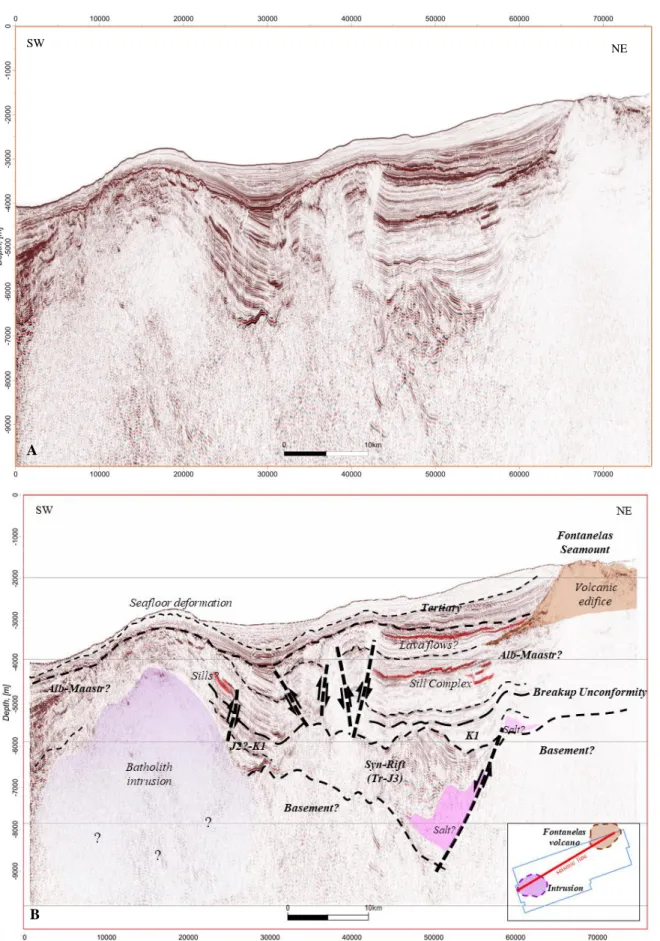
Figure 1.1. Seismic profile (A) not interpreted and (B) interpreted. This seismic profile is an important source of
information to this study, since it shows both the intrusion and the volcano magmatic features. It is also based on this seismic profile that the modelling of gravity and magnetic data was performed... 2
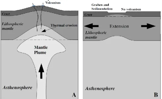
Figure 1.2. Illustration of the early stage of the tectonic evolution for (A) "active" and (B) "passive" rifting.
“Active” rifting displays lithospheric uplift and volcanism, whereas “passive” rifting displays graben formation and sedimentation without volcanism. From: Merle (2011). ... 3
Figure 1.3. Schematic sketch of the end-member extremes of passive continental margins: magma-poor and
volcanic rifted margins. SDRs = Seaward Dipping Reflectors; COT = Continent-Ocean Transition. From: Franke (2012). ... 5
Figure 1.4. Geographical setting of the study area. The SW polygon represents the area of 3D seismic survey,
which also includes the location of the intrusion and (partially) the Fontanelas volcano. The dashed white line represents the approximate outline of the Estremadura Spur. GB = Galicia Bank, VGS = Vasco da Gama Seamount, VS = Vigo Seamount, PS = Porto Seamount, IAP = Iberia Abyssal Plain, TS = Tore Seamount, ES = Estremadura Spur, TAP = Tagus Abyssal Plain, GoB = Gorringe Bank, HAP = Horseshoe Abyssal Plain, MPH = Marquês de Pombal High and SP = Sagres Plateau. ... 7
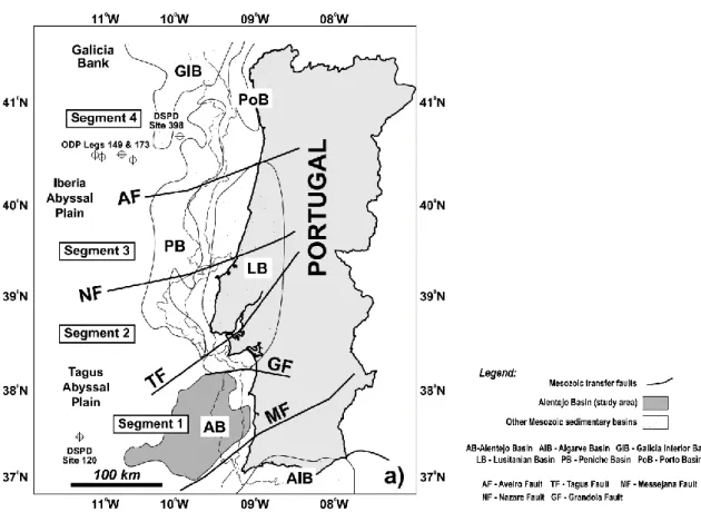
Figure 2.1. Map of the West Iberia continental margin showing the Mesozoic basins and the major transfer
faults. From: Alves et al. (2009). ... 10
Figure 2.2. Lithostratigraphic record, magmatic episodes and major tectonic events of the West Iberian margin.
Adapted from Pereira et al. (2017). ... 11
Figure 2.3. Paleogeographic reconstruction of the North Atlantic realm during the a) Late Jurassic (150 Ma), b)
Aptian-Albian boundary (112 Ma), c) Late Cretaceous (70 Ma) and d) Miocene (13 Ma). From Hay et al. (1999). ... 12
Figure 2.4. Regional magnetic anomaly map (Meyer et al., 2017). The onshore magnetic anomalies correspond
to the Sintra-Sines-Monchique massifs, whereas the offshore magnetic anomalies are the Portimão-Guadalquivir Banks, the Fontanelas Seamount and the intrusion. The two latter magnetic anomalies are the main targets of this study. The bathymetry features are GB = Galicia Bank, VGS = Vasco da Gama Seamount, VS = Vigo Seamount, IAP = Iberia Abyssal Plain, TS = Tore Seamount, TAP = Tagus Abyssal Plain and SP = Sagres Plateau. ... 14
Figure 3.1. Bathymetric map of the region, with the survey acquisition lines. ... 18 Figure 3.2. Survey design map of 3D seismic data acquisition, with the acquisition swaths indicated by blue and
purple areas. ... 20
Figure 3.3. Two categories of techniques to interpret potential field data: forward and data enhancement. A is
the measured anomaly, A0 is the calculated anomaly and A’ is the transformed measured anomaly. Adapted
from Blakely (1995). ... 21
Figure 3.4. GM-SYS 2D model. The pink plane corresponds to the (x,z) plane where the modelling is
performed. From: GM-SYS user’s guide from Northwest Geophysical Associates, Inc. (NGA, 2004). ... 24
Figure 3.5. Geometrical convention used in the calculous of the x- and z-components expressions of the
gravitational acceleration at the origin due to a polygon of density ρ. Adapted from Won and Bevis (1987). ... 25
Figure 3.6. Geometrical conventions used in the calculous of the magnetic anomaly. The angles I and β
represent the inclination of the Earth's magnetic field and the strike of the polygon, respectively. S1 and S2
are stations. In this example the polygon has six vertices. Adapted from Won and Bevis (1987). ... 26
Figure 4.1. Free air anomaly map... 32 Figure 4.2. Bouguer anomaly map. The A-A’ line represents the location of the 2D modelling profile. ... 32
Figure 4.3. Regional anomaly map calculated through the filtering technique. ... 33
Figure 4.4. Residual anomaly map calculated through the filtering technique. ... 33
Figure 4.5. Concepts and relationships of the magnetic field components. From: Li and Pilkington (2016). ... 34
Figure 4.6. Vector representation of the total field anomaly. Adapted from Blakely (1995). ... 36
Figure 4.7. Magnetic field of a dipole (from Blakely, 1995). ... 36
Figure 4.8. Total magnetic field map, with the bandpass filter applied. ... 37
Figure 4.9. Reduced to pole magnetic map. The A-A’ line represents the location of the 2D modelling profile. 37 Figure 4.10. Magnetic anomaly a) before and b) after being reduced to pole (from Blakely, 1995). ... 39
Figure 4.11. Horizontal derivative (x-direction) map of the gravity data... 40
Figure 4.12. Horizontal derivative (x-direction) map of the magnetic data. ... 40
Figure 4.13. Horizontal derivative map (y-direction) of the gravity data... 41
Figure 4.14. Horizontal derivative map (y-direction) of the magnetic data. ... 41
Figure 4.15. Vertical derivative map of gravity data. ... 42
Figure 4.16. Vertical derivative map of magnetic data. ... 42
Figure 4.17. Analytic signal map of gravity data. ... 44
Figure 4.18. Analytic signal map of magnetic data. ... 44
Figure 4.19. Radially averaged power spectrum (top) and depth estimate graphic (down) of the gravity data. .. 45
Figure 4.20. Radially averaged power spectrum (top) and depth estimate graphic (down) of the magnetic data. 46 Figure 4.21. Upward continuation filter applied to gravity data (continuation height = 12000 m). ... 48
Figure 4.22. Upward continuation filter applied to magnetic data (continuation height = 12000 m). ... 48
Figure 4.23. Tilt derivative map of gravity data. ... 49
Figure 4.24. Tilt derivative map of magnetic data. ... 49
Figure 4.25. Euler solutions map of the gravity data, using a structural index of 0 (equivalent to sills and dykes structures) and a window size of 20 km. ... 52
Figure 4.26. Euler solutions map of the magnetic data, using a structural index of 0.5 (equivalent to contrast zones, e.g. faults) and a window size of 20 km. ... 52
Figure 4.27. Source Edge Detection (SED) map of the magnetic data. ... 53
Figure 5.1. Initial gravity 2D model: A) panel with the density values and the structure of each block, B) panel with the seismic background image, the density values and structure of each block and C) the colour of each block it is in accordance with a density’s colour scale. The location of the model profile (A-A’) is presented in Figure 4.2, over the Bouguer anomaly map. ... 59
Figure 5.2. Final gravity 2D model: A) panel with the density values and the structure of each block, B) panel with the seismic background image, the density values and structure of each block and C) the colour of each block it is in accordance with a density’s colour scale. The location of the model profile (A-A’) is presented in Figure 4.2, over the Bouguer anomaly map. ... 61
Figure 5.3. Initial magnetic 2D model: A) panel with the susceptibility values and the structure of each block, B) panel with the seismic background image, the susceptibility values and structure of each block and C) the colour of each block it is in accordance with susceptibility’s colour scale. The location of the model profile (A-A’) is presented in Figure 4.8, over the reduced to pole (RTP) magnetic map. ... 63
Figure 5.4. Final magnetic 2D model: A) panel with the susceptibility values and the structure of each block, B)
panel with the seismic background image, the susceptibility values and structure of each block and C) the colour of each block it is in accordance with susceptibility’s colour scale. The location of the model profile (A-A’) is presented in Figure 4.8, over the reduced to pole (RTP) magnetic map. ... 65
List of tables
Table 4.1. Structural Index (SI) applied in Euler's deconvolution as a geological constraint. Adapted from (Reid
et al., 2014). ... 51
Table 5.1. Chosen densities for each block of the initial gravity model (see Figure 5.1). The references mention
the published scientific literature from where the density values were taken, and, in the case of the Fontanelas volcano and the Estremadura Spur Intrusion (intrusion), also include the studies that allowed defining its possible lithology. See annexe 4, for the table of densities adapted from Telford et al. (1990). 58
Table 5.2. Density values for each block of the 2D gravity model and its possible interpreted lithology... 60 Table 5.3. Chosen susceptibilities for each block of the initial magnetic model (see Figure 5.3). The references
mention the published scientific literature from where the susceptibility values were taken, and, in the case of the Fontanelas volcano and the Estremadura Spur Intrusion (intrusion), also includes the studies that allowed defining its possible lithology. See annexe 5, for the table of susceptibilities adapted from Telford et al. (1990). ... 62
Table 5.4. Susceptibility values for each block of the 2D magnetic model and its possible interpreted lithology.
... 64
Table 6.1. Density and susceptibility values obtained through the 2.5D modelling of the potential field data, as
well as the possible lithologies attributed to the targets. ... 69
Table 6.2. Density, susceptibility and lithology for several igneous bodies offshore and onshore the Iberia. The
density and susceptibility values for the Sintra and Sines massifs and the Foz da Fonte sill were obtained through rock sample measurements, whereas the Guadalquivir-Portimão Bank values are referent to modelling results. All these igneous bodies are related with the Late Cretaceous magmatic cycle. ... 70
Acronyms
ESI Estremadura Spur Intrusion
IGRF International Geomagnetic Reference Field RTP Reduced to Pole
Chapter 1: Introduction
1.1.Rationale
Rifted continental margins are one of the most complex geological entities, being intensively studied not only from the academic point of view, but also for their economic importance, due to the occurrence of geological resources, from which oil and natural gas comprise the vast majority. Understanding the geological process that underpin the formation and evolution of these resources led academia and industry, to scrutinize this type of margins. Newfoundland is an example of a proliferous margin, concerning the petroleum and mineral exploitation, contrasting with the absence of known economic geological resources of the West Iberian Margin (WIM, corresponding to the Atlantic margin of Portugal and Spain). Economic aspects apart, these conjugated margins were, and continue to be, an important key to define the geological context associated with the continental margins (e.g. Wilson et al., 2001; Manatschal et al., 2010).
The West Iberian Margin is one of the best-studied continental margins and, in addition to the many published papers (e.g. Boillot et al., 1979; Pinheiro et al., 1996; Wilson et al., 2001; Russell and Whitmarsh, 2003; Manatschal, 2004; Reston, 2007; Tucholke and Sibuet, 2007; Alves et al., 2009; Manatschal et al., 2010; Martins et al., 2010; Pereira and Alves, 2011; Pereira et al., 2017), this margin has also been the subject of the Deep Sea Drilling Project (DSDP), the Ocean Drilling Program (ODP), numerous seismic experiments, as well as other variety of geological, geophysical and biological studies.
This master’s thesis is incorporated on a partnership between the Faculty of Science of the University of Lisbon (FCUL) and Partex Oil and Gas, under the scope of the wider project entitled “Magmatism on passive margins and its implications for effective petroleum systems in the Atlantic: a case study from West Iberian Margin”, in which the major goal is to investigate magmatism on the West Iberian Margin and its contribution on petroleum systems.
The motivation of this study is grounded in the recent advances in the knowledge of continental rifting and post-breakup of West Iberia (e.g. Alves et al., 2009; Pereira and Alves, 2011; Soares et al., 2012) and also in the discovery of an enigmatic geological feature located southwest of the Fontanelas volcano (e.g. Pereira et al., 2017). This feature was identified based on new 3D seismic data offshore central Portugal (Pereira, personal communication), in the Estremadura Spur. Its nature and geometry are unknown, although, according to its seismic stratigraphic criteria (including, the information from the seismic facies and reflectors; Figure 1.1), it likely correspond to a magmatic intrusion with a granitic nature and batholith shape.
The interpretation of seismic profiles provides important information about the geometry /structure of the bodies, as well as the relative geological ages through seismic stratigraphy and, consequently, suggests a possible lithology.
In this thesis it is proposed a geophysical characterisation of the intrusion and of the Fontanelas volcano, which will led to a geological description of the possible lithology and geometries associated with both targets. This task will be accomplished by applying qualitative (signal enhancement techniques) and quantitative (2.5D modelling) methods to potential field data (gravity and magnetic) constrained by seismic data.
Figure 1.1. Seismic profile (A) not interpreted and (B) interpreted. This seismic profile is an important source of information
to this study, since it shows both the intrusion and the volcano magmatic features. It is also based on this seismic profile that the modelling of gravity and magnetic data was performed.
SW NE
A
The importance of this study is supported by numerous aspects, including: 1) knowledge of a new area; 2) knowledge of a new magmatic feature, which has never been studied before; 3) study of a paleo-volcano that has never been studied through potential field data and 4) explore the potentiality of gravity and magnetic data, as well as the methodology applied to improve the characterisation of shallow magmatic plumbing systems (e.g. Magee et al., 2018).
Regarding the presence of magmatic features on the offshore areas of the WIM, this study contributes to increase the knowledge on its thermal evolution and, ultimately, on the regional effects on widespread uplift and impact on postulated petroleum systems. Despite its regional implications, this study may also be important in clarifying the importance of magmatic events on continental margins worldwide, especially in margins throughout the Atlantic.
1.2.Magmatism on passive continental margins
The classification of continental margins resulting from extension of the lithosphere was first introduce by Sengör and Burke (1978), that divide it into “active” and “passive” continental margins, according to the forces that initiated rifting.
Continental rifting is traditionally described as a thinning process of the lithosphere which ultimately leads to continental breakup, formation of a mid-oceanic ridge and seafloor spreading (Merle, 2011). This stretching may result from one of two distinct types of rifting (Corti et al., 2003; Geoffroy, 2005; Merle, 2011). The active rifting is defined by thermal upwelling of the asthenosphere as a result of the ascent of a mantle plume to the base of the lithosphere (Figure 1.2), implying that the mantle upwelling is an active process of the deformation (Merle, 2011). This type of continental rifting is characterised by crustal doming and abundant volcanism during early stages (Merle, 2011).
In passive rifting, the plate tectonics drives to lithospheric extension, as a result of regional stresses located within or at the boundaries of the lithosphere (Geoffroy, 2005; Merle, 2011). The passive rifting exhibits graben formation and marine sedimentation in the first stage, followed by volcanism at
Figure 1.2. Illustration of the early stage of the tectonic evolution for (A) "active" and (B)
"passive" rifting. “Active” rifting displays lithospheric uplift and volcanism, whereas “passive” rifting displays graben formation and sedimentation without volcanism. From: Merle (2011).
a later stage (Figure 1.2; Merle, 2011), although this type of continental rifting is characterised by a scarcity of igneous activity compared with the active rifting. Nevertheless, the subsidence, and consequent sedimentation, occurs both during the syn- and post-rift stages (Geoffroy, 2005). In this type of margin, the role of magma intrusion in favouring and focusing extension may be important as the lithosphere can be both thermally weakened or compositionally strengthened by cooled mafic intrusion (Geoffroy, 2005).
Passive margins are characterised by variable crustal stretching, rift-related faulting and igneous activity (e.g. Alves et al., 2009). As a result, this type of margin can be subdivided into “volcanic” or “non-volcanic” (see Wilson et al., 2001, and references therein), depending on the timing and relative amount of magmatic activity in relation to lithosphere extension and breakup (Geoffroy, 2005). Manatschal (2004) renamed the “non-volcanic” to “magma-poor” passive margin. This latter term is more appropriate, because there is not a single passive margin that is completely absent of intrusive and extrusive rocks (Franke, 2012; Russell and Whitmarsh, 2003).
Volcanic passive margins (Figure 1.3) are commonly associated with the Large Igneous Provinces (LIP; Geoffroy et al., 2015). The breakup of lithosphere mantle occurs first or during the breakup of the crust, resulting in the extrusion and intrusion of large amounts of syn-rift magmatism. In this case, all stages, until the continental breakup, are accompanied by magmatism (Geoffroy, 2005). One distinctive feature associated with this type of margins, and recognized in the seismic data, is the presence of strongly reflective Seaward Dipping Reflectors (SDR) sequences due to the development of flood-basalts during continental breakup (Geoffroy, 2005).
Magma-poor passive margins (Figure 1.3) are characterized by (Reston, 2016): 1) low-moderate sediment accumulation rates, 2) extreme crustal thinning and highly rotated fault blocks, 3) detachment faults rooting at deep crustal levels and 4) the presence of a transitional domain from the continental to the oceanic crust. The structure of magma-poor margins is known due to their transparency to seismic waves, comparing with the volcanic margins which are poorly constrained due to the strong impedance contrast within the SDRs (Geoffroy, 2005). The best-known examples of magma-poor margins comprise the Brazil-Angola, the NW Australian, the South China Sea and the Iberia-Newfoundland. These latter margins are a type-example in the study of the geometry and processes related to magma-poor rifted margins.
Iberia-Newfoundland margins are characterised by 1) polyphasic rifting, 2) localized deformation, migrating towards the area of final breakup (ocean-continent boundary) and 3) magmatism, which includes underplating, diking and extrusion of alkaline magmas before, during and after continental breakup (Manatschal et al., 2010). As a result of forces exerted in the lithosphere, rifted margins develop distinct crustal architectures during their evolution (Pereira, 2013). According to Manatschal et al. (2010), the Iberia-Newfoundland margins reveals five distinct crustal domains referred to as: proximal margin, necking zone, distal margin, the ocean-continent transition (OCT) and the oceanic crust. These domains contrast with the classical rift models, which distinguish only two main domains: continental and oceanic (Manatschal et al., 2010).
The distal margin is characterised by highly rotated upper crust tilt blocks (Pereira, 2013) and formed by an hyper-extended crust domain, where the crust thins to less than 10 km (Manatschal, 2014; Manatschal and Bernoulli, 1999, 1998). Hyper-extension is defined by an extreme stretching process conducting to a coupled and embrittled lower and upper crust, allowing main faults to penetrate to the mantle (Doré and Lundin, 2015). Mantle exhumation leads to partial hydration (serpentinization) of the uppermost mantle (Doré and Lundin, 2015), in response to depth-dependent extreme thinning and polyphase faulting (Manatschal, 2014; Ocdanologique and Azur, 2001).
Concerning its global geodynamic significance, hyper-extended margins may have significant roles at critical stages of the Wilson Cycle, since the presence of weaker exhumed mantle, due to the partial replacement of peridotite by serpentinite, and the extreme crustal thinning may become important in localizing subduction events (Doré and Lundin, 2015).
As referred previously, this type of rifted margin is not entirely devoid of magmatism. West Iberia (as well as other Atlantic magma-poor margins) shows occasional magmatic activity during the rifting process and subsequent post-rift evolution (Pereira, 2013). Throughout West Iberia, magmatic events are described in the Late Triassic – Early Jurassic, Late Jurassic – Early Cretaceous and in the Late Cretaceous (e.g. Martins et al., 2008; Miranda et al., 2009; Pinheiro et al., 1996; Tucholke and Sibuet, 2007).
This study will focus on the latter magmatic cycle (Late Cretaceous) being the most voluminous and widespread episode of the WIM, and responsible for the formation of the onshore complexes of Sintra (Terrinha et al., 2003), Sines (Ribeiro et al., 2013) and Monchique, the volcanic complex of Lisbon and other several minor intrusions, which include the Foz da Fonte (Neres et al., 2014, 2012) and Paço de Ilhas (Neres et al., 2012) sills. Several authors also correlated various offshore seamounts with this magmatic event in the WIM: the Tore Seamount (Neres et al., 2014; Roque et al., 2009), the Fontanelas Seamount (Miranda et al., 2010) and, more recently, the Guadalquivir-Portimão Banks (Neres et al., 2018).
Figure 1.3. Schematic sketch of the end-member extremes of passive continental margins: magma-poor and volcanic rifted
1.3. Potential field data and methodology
A likely magmatic intrusion and the Fontanelas volcano are the main targets of this study. These two magmatic features are studied through potential field data (i.e. gravity and magnetic) acquired during a seismic campaign by Austin Exploration Inc, offshore Portugal, during 2008, as part of industry exploration activities on the margin.
The gravity exploration method consists on the study of the mass distribution in the subsurface. This technique provides information on the density distribution in the crust and allows the identification of anomalous geological features with distinct density, which stands out from the background geology. The gravity method uses measurements of the gravity acceleration at different locations, in the case of this study, aboard a marine vessel. The lithology is one of the possible geological information that can be derived from the gravity data, since the strength of the gravitation field is directly proportional to the mass and, therefore, the density of crustal materials, enabling inference of rock type (Lichoro, n.d.). Besides lithological information, contrasting densities also allows to detect and delineate geological discontinuities, faults, intrusions, dykes, among others (Lichoro, n.d.).
On the other hand, the magnetic method studies the distribution of the magnetic properties (i.e., susceptibility, remanence) in the earth’s crust, by recording the variations in the magnetic field due to lateral variability in the magnetization of the magnetic minerals in the crust (Lichoro, n.d.). Similarly to the gravity method, the magnetic method is also able to provide lithological and structural information. The variation of magnetization of magnetic minerals throughout the crust gives rise to magnetic anomalous regions, which are indicative of structural contrasts, allowing the mapping of basements structures, fault systems, dykes and intrusions (Lichoro, n.d.).
The use of potential field data has several advantages: 1) they are a passive and non-destructive geophysical method, 2) the acquisition is faster and cheaper than most geophysical techniques, 3) the data can be acquired simultaneously with other geophysical methods and 4) they have multiple applications (engineering, environmental, geothermal studies, among others). The biggest disadvantage of potential field data is related to the non-uniqueness character of the results, which implies the use of other sources of information to fully interpret and understand the results (Lichoro, n.d.). However, the potential field data can give us a lot of different information and be one of the best geophysical methods to apply in known and unknown areas as a first geophysical approach.
In this study, potential field data was constrained by 3D seismic data. The availability of these three datasets (gravity, magnetic and seismic) allows the access to several pieces of information, such as structural, by the interpretation of seismic profiles, and physical, by obtaining density and susceptibility values with the modelling of gravity and magnetic data, respectively.
Applying potential field data, within the geological context of this work, is very advantageous, because it is expected that the magmatic features under study stand out from the background structures as anomalous zones. Several studies applied potential field data to study the continental margins, e.g. Srivastava et al. (2000), Russell and Whitmarsh (2003), Bronner et al. (2011), Girolami et al. (2016), Casacão et al. (2018), Neres et al., (2018), Bernard et al. (2019) and Sanchez et al. (2019).
Concerning the methodology applied in this work, potential field data was used to perform a regional analysis through enhancement techniques, while the analysis with greater detail was completed by the modelling of the potential field data with the aid of 3D seismic data.
1.4. Location and physiography of the study area
The study area is located in the offshore southwestern part of the continental margin of Portugal, extending from Lisbon to Porto (Figure 1.4). The target magmatic bodies of this study are located in the Estremadura Spur (ES, Figure 1.4), which constitutes an important submarine promontory. With a roughly trapezoidal shape, elongated in an east-west direction, it has about 200 km length and 90 km width, extending from the coastline to the Tore Seamount (Badagola, 2008).
Figure 1.4 shows the location of the regional study area in relation with Iberia, and the polygon at the SW indicates the area where 3D seismic data were acquired, which comprises both the location of the intrusion and (partially) the Fontanelas seamount.
1.5. Objectives
The purpose of this study is to characterize the geometry and nature of the two major magmatic features on the Estremadura Spur (Figure 1.4), namely the Fontanelas volcano and the southwest intrusion, based on gravity and magnetic data modelling, supported and constrained by 3D seismic data. This thesis also intends to correlate this intrusion and the Late Cretaceous post-rift magmatic event, based on the seismic data evidence and the similarities between onshore and offshore analogues on the West Iberian Margin.
Figure 1.4. Geographical setting of the study area. The SW polygon represents the area of 3D seismic survey, which also
includes the location of the intrusion and (partially) the Fontanelas volcano. The dashed white line represents the approximate outline of the Estremadura Spur. GB = Galicia Bank, VGS = Vasco da Gama Seamount, VS = Vigo Seamount, PS = Porto Seamount, IAP = Iberia Abyssal Plain, TS = Tore Seamount, ES = Estremadura Spur, TAP = Tagus Abyssal Plain, GoB = Gorringe Bank, HAP = Horseshoe Abyssal Plain, MPH = Marquês de Pombal High and SP = Sagres Plateau.
Considering the goals, it is possible to define a set of questions related to this study:
What is the geometry and magmatic nature of the intrusion?
Is it possible to correlate this intrusion with other magmatic events onshore/offshore the margin?
Is the magmatism, along the West Iberia passive margin, more widespread than initially anticipated?
What are the implications of magmatism for the evolution of the West Iberian margin?
1.6. Thesis outline
The work developed during this research was organized into seven chapters, in order to fully address the questions referred in the previous section. Under the framework of this thesis, the preliminary analysis and results were presented in the EGU General Assembly 20191.
Chapter 1, in which this section is included, introduces the reader to the main themes developed in this study, including the fundamental aspects associated with the geological context of the continental margins and the data and methodology applied in this work.
Chapter 2 focuses on the major geological events that occurred in the Iberian margin over time, including the description of the main lithostratigraphic units, geodynamics and tectonic evolution. It is also highlighted the most important magmatic events that occurred in the region, focusing on the Late Cretaceous cycle.
Chapter 3 provides a description and acquisition conditions of the different datasets used in this study, which include bathymetry and potential field data (2D) as well as seismic data (3D). It is also described the theoretical principles of the 2D modelling theory.
Chapter 4 introduce an initial data analysis, through the application of several signal enhancement techniques, addressing a theoretical overview of the potential field data and some necessary corrections.
Chapter 5 presents the results of the 2.5D modelling method, describing and justifying the density and susceptibility values obtained in both gravity and magnetic model.
In Chapter 6 an integrated discussion of the results is presented, including the nature and geometry of the magmatic targets, according to the density and magnetic susceptibility values obtained through the modelling process in chapter 5.
Chapter 7 presents the conclusions and some indications for future work concerning the topics developed throughout the thesis.
1
Escada, C., Santos, F., Represas, P., Pereira, R., Mata, J., 2019. Post-rift magmatism on the central West Iberian Margin : New evidence from magnetic and gravimetric data inversion in the Estremadura Spur, in: EGU General Assembly. https://doi.org/10.1144/jgs2016-050
Chapter 2: Geological setting
2.1.West Iberian Margin
The evolution of the West Iberian Margin (WIM) begins during the Paleozoic, with the convergence and collision of the two major continents (Laurasia and Gondwana), which led to the formation of the supercontinent Pangea and gave rise to the Variscan Orogenic Belt (often referred as Hesperic Massif, Pinheiro et al., 1996). This accreted massif hosts Precambrian and Paleozoic rocks, which were intruded by large batholiths during and after the Variscan continent-continent collision (Pinheiro et al., 1996).
The pre-Mesozoic tectonic inheritance is associated with the basement of the WIM, a part of the Ibero-Armorican arc, which constitutes the main macrostructure in Western Europe formed during the Variscan Orogeny, namely from Middle Devonian to Carboniferous (Dias and Ribeiro, 1995). By the end of the Paleozoic, Iberia was part of Pangea, which comprised almost all the continental masses in one single super-continent (Terrinha et al., 2019). In Permian times, Late Variscan faulting developed after cratonization of the Variscan Orogen (Terrinha et al., 2019).
On the West Iberian Margin, the Mesozoic evolution was strongly controlled by the opening of the North and Central Atlantic Ocean and the westernmost segment of the Tethys, initiated by mid to late Triassic. The re-activation of inherited Late Variscan tectonic structures played an important role in the formation of sedimentary basins, both onshore and offshore (e.g. Pinheiro et al., 1996). The reactivated strike-slip faults, oriented ENE-WSW and SW, were the main extensional faults, controlling the multi-phased rifting in West Iberia (Alves et al., 2009; Pereira et al., 2017; Terrinha et al., 2019).
The Mesozoic evolution on the WIM comprises four distinct rifting episodes that control the geometry and deposition of the different basins (e.g. Pereira and Alves, 2011): 1) Late Triassic (Norian) to Early Jurassic (Hettangian), 2) Early Jurassic (Sinemurian) to late Middle Jurassic, 3) Late Jurassic (Oxfordian) to earliest Cretaceous and 4) Early Cretaceous (Berriasian-Aptian). These rifting events led to the deposition of distinct megasequences, exposed in outcrops and observed on seismic reflection data, both onshore and offshore (e.g. Alves et al., 2009; Pereira and Alves, 2011; Rasmussen et al., 1998).
West Iberia is a North striking passive margin with multiple Mesozoic basins (Figure 2.1; Alves et al., 2009). Two first-order transcurrent zones, the Messejana-Plasencia Fault and the Nazaré Fault, controlled the Mesozoic rifting phases (Groupe Galice, 1979), and subdivide the WIM into three distinct segments (e.g. Alves et al., 2009; Pereira et al., 2017), namely: 1) at the South, the Algarve and Cadiz Basins, 2) in SW Iberia, the Alentejo Basin and 3) in NW Iberia, the Peniche, Lusitanian, Porto and Galicia Basins (Figure 2.1). Additionally, the Aveiro and Tagus strike-slip faults also play a significant role in margin segmentation and controlling the deposition of individual sub-basins (e.g. Alves et al., 2009).
In the Late Triassic, the continental extensional regime led to the initial rifting of Iberia and the onset of the first rifting episode (e.g. Pereira and Alves, 2011). Iberia was located at the triple junction of the Variscan suture zone, between Laurasia, Gondwana and the western end of the Tethys Ocean, creating the necessary conditions for crustal stretching and thinning around Iberia (Terrinha et al., 2019). This geodynamic context allowed the formation of intra-continental rifts, and its associated sedimentary basins, on the SW and West Iberia. This Late Triassic to earliest Jurassic rifting event is
characterised by the deposition of continental red beds and evaporites (Figure 2.2; Azerêdo et al., 2003).
In the Jurassic, the beginning of the sinistral oblique movement of West Africa with respect to Eurasia triggered the propagation of the Tethys Ocean towards the North Atlantic rifts (Terrinha et al., 2019). The onset of the second rift phase is marked by widespread magmatism on the Central Atlantic Magmatic Province (CAMP; Martins et al., 2008) and subsequent formation of a dominantly carbonate platform that records the progressive increase of marine conditions throughout the WIM, with the deposition of carbonated lithotypes, including limestones and dolomites (Figure 2.2; Azerêdo et al., 2003).
From the Late Triassic to the latest Jurassic-Early Cretaceous, SW Iberia evolved as an hyper-extended continental rift margin, until the generation of oceanic crust in the Tagus Abyssal Plain, after continental breakup (Manatschal and Bernoulli, 1998; Mauffret et al., 1989).
The oceanic spreading was diachronous throughout the Iberian margin, with the first event of continental breakup on the SWIM likely by the end of the Jurassic (Figure 2.3a; Mauffret et al., 1989; Pereira and Alves, 2011), followed by formation of oceanic crust and continental mantle exhumation of the hyper-extended crust in NW Iberia from Barremian to Aptian (ca. 128 to 110 Ma; Wilson et al., 2001), and ultimately, in the northern Iberia during the Late Cretaceous.
The opening of the Bay of Biscay started between 130-118 Ma and ended 80 Ma ago, as the result of the continued movement of the oceanic spreading towards the north, giving rise to SE motion and anti-clockwise 35º rotation of Iberia (Miranda et al., 2009). After complete breakup (Aptian-Albian, 112 Ma; Figure 2.3b), West Iberia underwent a period of relative tectonic quiescence in the Late
Figure 2.1. Map of the West Iberia continental margin showing the Mesozoic basins and the major transfer faults. From:
Cretaceous (Figure 2.3c) and progressive development of the drift phase (e.g. Pereira and Alves, 2012).
The Cretaceous sedimentary sequence records syn- and post-rift tectonic environments (e.g. Groupe Galice, 1979), despite the relative sea-level variations influence in the facies distribution, the Cretaceous is characterized by a generalized low rate of subsidence and deposition. (Proença Cunha and Pena dos Reis, 1995). In the Aptian-Albian boundary there was an expansion of the sedimentation area accompanied with the deposition of coarse siliciclastic sediments, followed by a later development of marine carbonates influenced by the long-term Albian-Cenomanian transgression (Proença Cunha and Pena dos Reis, 1995).
Figure 2.2. Lithostratigraphic record, magmatic episodes and major tectonic events of the
The beginning of the late Campanian, in the Lusitanian Basin, was marked by diapiric events and reactivation of the Nazaré-Lousã fault. Subsequently, the upper Campanian-Maastrichtian is recorded by the deposition of quartz sandstones grading to sandy dolostones and, occasionally, sandy limestones (Proença Cunha and Pena dos Reis, 1995).
The Cenozoic was marked by multiple compressional and tectonic inversion episodes (the Pyrenean and Alpine orogenies; Pinheiro et al., 1996). The convergence between Africa and Eurasia plates began in the Late Cretaceous, leading to collision 35 Ma ago. This compressive post-rift tectonic phase strongly affected the Tagus Abyssal Plain and the Estremadura Spur during the Miocene (e.g. Mougenot, 1989).
The two main compressional episodes, which affected the West Iberia Margin since the rifting ended, occurred during the Eocene and Miocene (Figure 2.3d), although inversion still occurs in recent periods (e.g. Duarte et al., 2013).
Figure 2.3. Paleogeographic reconstruction of the North Atlantic realm during the a) Late Jurassic (150 Ma), b)
Aptian-Albian boundary (112 Ma), c) Late Cretaceous (70 Ma) and d) Miocene (13 Ma). From Hay et al. (1999).
Laurasia Laurasia Eurasia Eurasia Newfoundland Newfoundland Iberia Iberia Iberia Iberia Gondwana Gondwana Africa Africa A B C D
The effects of this inversion include folding and reactivation of old Variscan structures, some of which had been reactivated during the rifting episodes (e.g. Pinheiro et al., 1996; Pereira and Alves, 2011). (Hay et al., 1999)
The onset of rapid collision and subduction between the Iberia, Eurasia and Africa plates resulted in the tectonic inversion of structures formed during the Mesozoic extensional periods (Miranda et al., 2009).
The building of the Pyrenean and Betic orogens and the internal deformation associated with the Iberia microplate controlled the formation and evolution of the Tertiary basins (Proença Cunha and Pena dos Reis, 1995). Extensional structures dominated the western Iberian passive margin, during the Paleogene to middle Tortonian times, until the late Tortonian-Quaternary compressional events (Betic orogeny) leading to the structural inversion of the Lusitanian basin (Proença Cunha and Pena dos Reis, 1995).
In Pliocene times the compressive phase and consequent tectonic inversion are related to the counter-clockwise rotation of Africa with respect to Iberia, changing from frontal to oblique collision (Neres et al., 2018).
2.2. Late Cretaceous magmatism
The West Iberian Margin was the locus of several magmatic cycles during the Mesozoic, occurring both in the Hesperic Massif (Central Iberian Zone) and in the Lusitanian Basin (Pinheiro et al., 1996). However, magmatism is mainly located to the south sector of the Nazaré Fault (e.g. Martins et al., 2008; Mata et al., 2015; Miranda et al., 2009; Pereira et al., 2017). The Mesozoic magmatic activity in the WIM is scattered and the volume of magma produced in these occurrences is insignificant compared with the volcanism that preceded and accompanied continental rifting (Pinheiro et al., 1996) and contrasting with other magma-poor margins (Franke, 2012).
During the Mesozoic, the WIM was punctuated by three phases of magmatic activity (e.g. Martins et al., 2008; Mata et al., 2015; Miranda et al., 2009): 1) Triassic- Jurassic tholeiitic cycle (200-198 Ma), 2) Jurassic-Cretaceous mildly alkaline cycle (148-140 Ma) and 3) Late Cretaceous alkaline cycle (94-69 Ma). The two first magmatic phases are associated with the Late Triassic and Late Jurassic rifting events, respectively, thus being syn-rift magmatic events, whereas the Late Cretaceous magmatic event occurred in a post-rift tectonic setting (Figure 2.2; Pinheiro et al., 1996).
The first Mesozoic magmatic event is represented in the SW Iberia and is characterized by tholeiitic basalts, which are considered as part of the Central Atlantic Magmatic Province, as well as dolerite-basaltic Messejana dykes with Late Triassic ages, related to the last phases of the Variscan orogeny in Iberia and the initial extensional phases of Pangea (e.g. Martins et al., 2008; Pinheiro et al., 1996; Verati et al., 2007).
The Late Jurassic–Early Cretaceous magmatic cycle was contemporaneous with a period of significant extension and lithospheric thinning in West Iberia (e.g. Pereira et al., 2017; Wilson, 1988). Evidence of magmatic features occurs mainly in the Lusitanian Basin, close to the onshore expression of the Nazaré Fault Zone, as transitional (mildly alkaline) dolerite sills and dykes associated to halokynesis (Mata et al., 2015). Ages from these intrusive rocks date the event at 148-140 Ma, evidencing a period of magmatic activity in response to a renewed rift phase.
The most voluminous and widespread magmatic event of the WIM occurred in the Late Cretaceous (third magmatic cycle) and is subdivided into two alkaline pulses that reveal the role of
sub-lithospheric mantle sourcing, which contrast with more sub-continental magmas from the previous magmatic cycles (Martins et al., 2010). The first pulse, occurred between 94-88 Ma, during the opening of the Bay of Biscay and consequent rotation of Iberia, mainly as sills, such as the Foz da Fonte (Neres et al., 2014, 2012) and Paço de Ilhas (Neres et al., 2012), around the Lisbon area. The second pulse (75-72 Ma) occurred in the southernmost part of Portugal (Algarve Basin) extending to Lisbon, and include both intrusive, such as the Sintra (Terrinha et al., 2017, 2003), Sines (Ribeiro et al., 2013) and Monchique massifs, and extrusive complexes. The latter event is coeval with the first pulses of tectonic inversion due to the onset of rapid convergence between the African and Iberian plates (Miranda et al., 2009).(Meyer et al., 2017)
Evidence of these two pulses includes (Grange et al., 2010; Martins et al., 2010; Miranda et al., 2009): 1) sills and dykes around Lisbon region and 2) the Lisbon Volcanic Complex (72.6 ± 3.1 Ma), the Sintra (~ 79 Ma), Sines (75.4 ± 0.6 Ma) and Monchique Igneous Massifs (72.7 ± 2.7 Ma). Neres et al. (2018), recently described an intrusion beneath the Guadalquivir-Portimão Banks emplaced in the lower and upper crust of the Algarve Basin. Additional magmatism also occur on the Madeira-Tore Rise (Merle et al., 2018, 2009), although in a distinct geodynamic setting than those observed onshore West Iberia (Pereira et al., 2017).
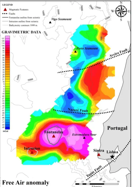
Figure 2.4. Regional magnetic anomaly map (Meyer et al., 2017). The onshore magnetic anomalies correspond
to the Sintra-Sines-Monchique massifs, whereas the offshore magnetic anomalies are the Portimão-Guadalquivir Banks, the Fontanelas Seamount and the intrusion. The two latter magnetic anomalies are the main targets of this study. The bathymetry features are GB = Galicia Bank, VGS = Vasco da Gama Seamount, VS = Vigo Seamount, IAP = Iberia Abyssal Plain, TS = Tore Seamount, TAP = Tagus Abyssal Plain and SP = Sagres Plateau.
The Sintra-Sines-Monchique complexes (Figure 2.4) are the most enigmatic events of the Late Cretaceous magmatic episode in the West Iberia Margin. These three igneous alkaline complexes intersect in different crustal contexts (Neres et al., 2018): the Monchique massif, is emplaced within unrifted basement, whereas the Sintra and Sines complexes are emplaced within the Lusitanian and Alentejo rift basins, respectively, developed during the opening of the Atlantic Ocean (Miranda et al., 2009).
The age distribution and the alignment of the Sintra, Sines and Monchique massifs (Figure 2.4) of West Iberia Cretaceous magmatism, led several authors to speculate about its origin, for example, Miranda et al. (2009) suggest the emplacement of deeply anchored mantle plumes and actively upwelling interacting with mid-ocean ridges and other major structures.
The last Mesozoic magmatic phase took place in a post-rift setting, 30 Ma after the beginning of oceanization in the Tagus Abyssal Plain, during the 35º anti-clockwise rotation of Iberia, the initiation of the alpine compression (partially coeval with the Pyrenean continental collision in Northern Iberia) and the onset of tectonic inversion on the Mesozoic basin (Miranda et al., 2009).
The target magmatic features (Figure 2.4) in this study are within the Estremadura Spur, an E-W underwater promontory located between Cabo Carvoeiro and Cabo da Roca (Badagola et al., 2006). This important physiographic feature of the West Iberia Margin stands out from the continental margin and is interpreted as an uplifted block of continental crust up to 100 km wide (Pereira et al., 2017). The Estremadura Spur and the Tore Seamounts separate the Iberia Abyssal Plain to the north and the Tagus Abyssal Plain to the south. The Nazaré Fault Zone limits the spur to the north and separates two distinct crustal domains (Pereira et al., 2017). Focused deformation on the Estremadura Spur includes folding and reverse faulting, which reveals the tectonic stresses that still prevail until the present (Pereira et al., 2017).
The Estremadura Spur (Figure 1.4) is punctuated with evidence of several intrusive bodies, including a volcano with more than 3000 meters high, the Fontanelas Seamount (Miranda et al., 2009; Pereira et al., 2017; Figure 2.4). According to Miranda et al. (2009), the Fontanelas volcano can be assigned to Late Cretaceous age based on its geochemical signature. Thus, being related to other anomalies of the same age in the region, namely the onshore alkaline magmatic bodies, such as the Sintra (Terrinha et al., 2017, 2003), Sines (Ribeiro et al., 2013) and Monchique massifs, the Foz da Fonte (Neres et al., 2014, 2012) and Paço de Ilhas (Neres et al., 2012) sills and the Lisbon Volcanic Complex.