Open-air rock-art, territories and modes
of
exploitation during the Upper Palaeolithic in the
C6a Valley (Portugal)
THIERRY
AUBRY,
XAVIER
MANGADO
LLACH,
JORGE
DAVID
SAMPAIO
&
FARID
SELLAMI"
A study OJ the differential preservation of the famous C6a engravings, in the light of the
site of Fariseu, place the distribution of the art in a chronological setting, which is in turn placed within the context of litliic raw material procurement.
Key-words: rock art, CBa Valley, Upper Palacolithk, dil'l'erential preservation, climate, resniirce exploitation
The natural environment
The C6a River is a left-bank tributary of the Douro, the major watercourse of the north central Iberian cordillera (FKX JRE 1) which crosses Ilieria from east to west rising to 2500 m. Tectonics controlled and facilitated Quaternary down- cntting south-north into the Pliocene planation surface known as the Mesetam, reaching about
400 m at the confluence with the Douro. The
120-km long riwr basin comprises two differ- ent geological sectors. The first, from source to within 1 7
km
of the confluence with the Douro, is through petrographically divcrsc granites. Thc second, wider, section grades to a meandering pattern through pre-Ordovician metamorphic rocks. The basin extends over 2419 sq. km (FIG-URE 1). Temperature records at its midpoint (1960-1970 - Figueira de Castelo Rodrigo sta-
tion) (FIGUKI: 2) indicate a mean annual tem- perature of 11.2"C and a wide annual range of 16.2OC. The lowest (December-March) are be- low 5°C; the highest above 35OC (July-August). Precipitation (mainly rainfall), is concentratcd in autumn, winter and, to a lesser degree, spring (FIGURE 3). Annual mean values are less than
1600 mm in the entire drainage basin, and av-
erage rainfall calculated from the map of isohyets (Daveaii 197113) is 818 mni. However, altitude causes important variations. Below 150 r n . pre- cipitation is less than 300 mm. As shown bv
the plot of the stream-flow at Cidadelhe sta- tion over two years of extreme precipitation levels (FIGURE 3 ) , the hydrological regime of the river's discharge is directly controlled by direct runoff induced hy the sharp gradients arid variation of rainfall in the drainage basin. Today, mainly vines, olive and almond trees are grown in terrace cultivation whose low drystone walls ensure that the thin and poor soils are pre- served. There is some rearing of sheep and goats.
The differential preservation of the archaeological record
The thin acid soils (Meireles, in ZilhBo et 01. 1997) and the iineven topography affect the preservation of the archaeological record. Ani- mal and macrobotanical remains are poorly preserved. Some heavily fragmented proto- historic animal bones have been recovered (Carvalho 1999). The schist-based sediments of the Cardina I Gravettian archaeological level have so lar only yielded a few burnt bone and teeth fragments. Somc very small. poorly pre- served charcoal fragments were found in dif- ferent levels; only three species have been recognized t q 7 Isabel Figueiral (pers. comm.):
Querciis ilex, Juniperus and Fraxinus, the first two probably intrusive. Tentative AMS and TL (quarxite) dating of Cardina have indeed shown that the charcoal fragments, found in contact
* Auhry 8r Sampaio, Parque Arqiieol6gico do Vale dci CBa. Ministerio da Cultura. Avenida Gago Cuuliilliu 19b, 5150
Vila Nova Fuz COa. Portugal]. Llach. Scminari d'Estudis i Rcccryues Prehistbriques, University of Barcelona. Baldiri
Reixac s/n, 08028 Barcelona, Spain. Sellaiiii. [J.E.R. Dynamiyiie des Milieux et Organisation Spatiale, INA P-G, BP 1.
78850 Grignon, France).
Rcccivcd 14 May 2001, acccptcd 2 October 2001, rcviscd 3 December 2003
OPEN-AiR ROCK-ART, TERRTTORIES AND MODES OF EXPLOITATION IN THE CdA VALLEY [PORTUGAL) 6 3 FlLL,Kh 1. Location of thc drainage basin in Iberia. C6a valley
64 THIERRY AUBRY, XAVIER MANGADO LLACH, JOKGE l)A\JID SAMPAlO 8r FAKID SEI,I.AMI Discharge (rn3/s)
j
TO I -20-
-- I 0 ?J 5 J FM
A J J A SFIGTIRE 2. Reconstruction of climatic coldest
non nth mean temperature: compurison of the
dischnrge i n Cidudelhe during two hydrologic
yenrs und with the hydrologicul present-day
regime of u drainage basin covered by snow
d tiring the wiri ter.
with a inore clayey layer, derive from soils formed during the Holocene (Mercier et ~ l . 2001). The palaeoenviroriment cannot be re- constructed from faunal and plant remains, and larger-scale palaeoclimatic models must be used. To locate lithics, the surviving evidence of
human occupation, we have attempted to de- fine the geomorphologiral contexts favourable to the accumulation of fine-grained sediments
in low-energy transport. In a steep environment, breaks of slope often accumulate wealhering debris and transport through surface runoff of the rocks forming the valley walls. In the C6a
basin, the older terraces are only very frag-
mentarily preserved, at c. 35-40 m above the modern river (FIGURE 4). One site has yielded some poorly djagnostic 'pebble-tools', with the same patina as the coarse terrace gravels. Sedi- mentologically similar terraces overlain by Eemian (?) red soils at the same elevation along the Douro contain handaxes and cleavers in secondary contexts. An artefactual date before
100,000 agrees with the tentative date of the palaeosols. Lower down, there is a ruck terrace, first detccted at Cardina I, roughly 20 m above the modern level of the stream (Zilhgo et al. 1995), which corresponds to a deviation of the watercourse caused by the presence of a rhyolite vein. Identical parent rock was identified at lower relative elevations of 6-1 0 m, at Quinta da Barc:a
and Quinta da Barca Sul (FIcuras 4 & 5). 1
I
Precipitation (mm)/Month ~ at Figueira castelo Rodrigo
and Castelo Melhor (10/1982 to 10/1995)
~ 100
10
t Discharge (m3/s) at Cidadelhe after the 01/10/1963 I
1 0.1 FIGURE 3. Actual data, monthly precipitation in Vale de Alfonsinho and Figtieiru de Castelo Rodrigo, precipi- tation, discharge in Cidndelhe (see
FIGURE 2) during two
distinct hydrological years.
OPEN-AIR ROCK ART, TERRITORIES AND MODES OF EXPl.OTTATTON IN THE COA VALJ.EY (PORTIJGAL) 65
66 THIERRY AIIERY, XAVIER MAN(:ADO LLA(:H, JORCE DAVID SAMPAIO & FARID SELLilhlI
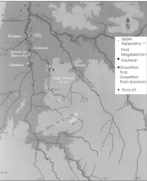
FIGURE 5. Distribution m a p s of rock art and upper Palaeolithic settlement in the Douro. Ribeira de Aguiar and tl7e C6a Valle~7.
Sunreys on the granitic plateau corresponding
to the 500-m high Pliocene planation surface
of the Iberian Meseta (Aubry 1998; 2001) also
found preserved sediments. The granites drained by the streams that funnel into the C6a have not been so severely incised as in the valley
OPEN-AIR ROCK-AKI', TERRITORJES AND MODES OF EXPLOITATION 1N THE COX VALLEY (PORTUGAL] 67
bottom, and granitic sands have accumulated on ledges and hollows circumscribed by rock outcroppings and the watcrr:ourses where the runoff concentrates. These local geomorpho- logical units are favourable to the preservation
of relict soils, arid the slope dynamics can be reconstructed. Buried palaeosol horizons have been identified in excavated sites of Olga Grande 4 and 1 4 (FIGURE 5) which retain diagnostic features of soil development (Sellami ZOOO).
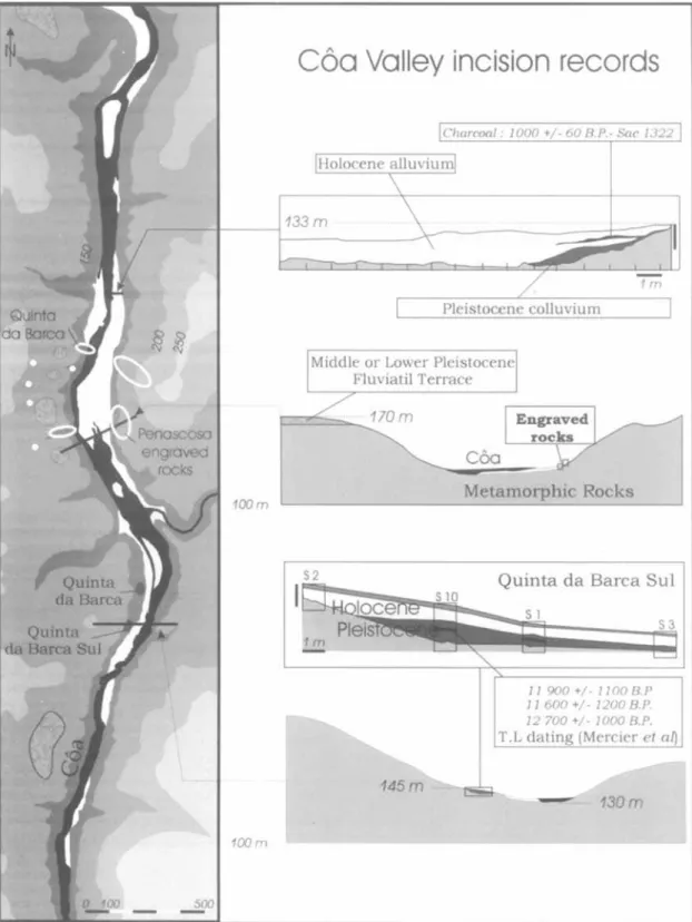
In 1995, under the supervision of J, Zilhgo, several test pits were sunk in the valley bot- tom alluvial deposits near rocks 4 and 5 of Penascosa (FIGURE 4) (Zilhgo 1997a) because the engraved pan& were found at the edge of
the floodplain. Although there was no archaeo- logical information, much was learnt about the modern valley bottom deposits at the highest floodwater level. A11 thc test pits, as well as a machine-dug trial trench located downstream from the engravings (FIGTJRE 4), have shown an alluvial seqiience (Meireles. in Zilhgo 1997a; Cordeiro & Rebelo 1996), dating structurally back to the Pleistocene (Ccirdeiro & Rebelo 1996). However, the other data suggest a Holocene age: fragments of ironware, modern pottery, etc. and a date of 10OOiGO BP (Sac: 1322) determined on
charcoals recovered 50 cm below the surface
of the trench. Two OSL dntcs confirm the Ho 1 ocene interpret at io n ; they were from Penascosa alluvial sands, at a depth of 1 m for the first (1000 KP) and an elevation of 50 cm
above the rock for the second (4000-6000 KP)
(Watchman, in Bednarik 1985). At the slope- facing edge of the trench, the characteristics of the tithostratigraphic unit (schist fragments with some rare rolled granite pebbles in a sandy matrix), interpreted as a remnant of Pleistocene colluvium (Zilhgo 1997a), point to its deposi- tion prior to an erosional phase (FlGllKb: 4). The geophysical tiorehole loggings made in front of Penascosa panels 3 , 4 and 5 reveal anasto- mosing channel fills, which correspond to depositional and erosional events, and are simi- lar to those observed in the trench downstream from the engravings (Alrneida, in Zilhilo 1997a). The deposits were repeatedly eroded hiring the Holocene.
Following the discovery, 1 kin downstream
at the site of Colmeal, of Upper Palaeolithic lithic remains, a test hole was sunk, and dis- (:overed a n eroded colluvium whose texture and structure were similar to those of the Pcnascosa
250 r n
FIGURE 6. Topogrnphy of the Fnriseu site.
trench. The lithics remains in the residual colluvium suggested that some Pleistocene al- luvial sediments might be preserved further downstream. liowever, the existence of the Pocinho dam built in 1975, controlling the level of the C6a over 7 krn, prevented observation of
the valley floor.
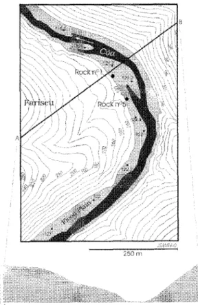
In December 1999, maintenance work along the Douro enabled survey of the topography of the C6a valley floor. On one of the river banks, several meanders display a morphology con- ducive to alluvium deposition and preserva- tion (Brown 1997), similar to Colmeal. The meander called Farisell, on the left bank of the
C6a some 6 kni from its confluence with the Douro, between the Piscos and Vale de Figueira ensembles, is adjacent to a slope with a gradi- ent of 3 0 % which rises to 409 m (FIGURE 6). The different stratigraphic seclioris (FIGURE 7) show that the uppermost part of the sequence
is composed of a silty alluvial deposit ensuing from its inundation ever since the Pociriho dam
G8 TIIlERRY AUBRY, XAVIEK MANGAUO LLACH. JOKGE DAVID SAMPAIO & FAKID SELLAM1
j
OPEN-AIR ROCK-ART, TERRITORIES AND MODES OF EXPLOITATION IN THE COA VALLEY (PORTUGAL) 89
I
-i-i:
- 14OWBF I Dates (B P B,/ T L j Mercier et oi, Valladas ei a/I"
FIGURE 8 . Chronology of the Cba valley Upper Palaeolithic sites based on TL dating and litliic industries.
composed of schist flagstones included within
a sandy matrix, traces of metal on these schists pointing to a modern age. The dip of the stony beds and of the base of layer 2 indicates that it was deposited after an erosional event whose dip corresponds to that of the slope, and which truncated unit 3 and the underlying units of lower angle dip (FIGURE 7). The differencc in dip of the two parts of the sequence, the clayey coating on the upper face of the slabs of layers 4c and 4e, and the fact that lithic industries diagnostic of the upper Paleolithic were only found in the levels where slabs are present, argue in favour of a deposition during the Upper Pleistocene for this sequence. The 1.5-m thick sequence displays a succession of fine-grained alluvial sediments with a high mica content, deposited during periodic high flows, and prob-
ably anthropic accumulations of slabs associ- ated with lithic remains. Their orientation and the fact that pieces could be refitted testify to minimal transportation linked to surface run-
off. The arguments concerning the chronological attribution of the different archaeological lev- els and the correlations established with [he other sites in the valley are discussed below.
Human occupation during the Upper Paleolithic: archaeological remains and
context
The chrono-stru figruphic sequence
Application of thc above geomorpholngical model led to the discovery of over 30 sites with lithir: industries that are technologically and typologically attributable to the Upper Palaeo- lithic (FIGURE 5). Nine of these sites have bccn tested and four are now in the course of exca- vation, The establishment of n chrono-strati- graphic sequence of human occupation for the region is based on the stratigraphic: sequences of the sites of Cardina I (collaboration with X. Mangado and J.M. Fullola of the S.E.R.P. of the LJniversity of Rarcclona), Quinta da Barca Sul (collaboration with X. Chauvikre of the Uni- versity of Neuchatel), several loci of Pedras Altas (Olga Grande 4, 13 and 14), and Fariscu (FIG-
URE 5).). The chronology of these occupations
(FIGUKE 8) was first defined by diagnostic lithic tools and confirmed by therrnoluminescence (TL) dating of fragments of heated siliceous stones found in the different layers of these stratified sites (Valladas et 01. 2001; Mercier et
7 I1 THIERRY AUBKY, XAVIER MANGADO LLACII, JORGE DAVID SAMPAIO & FARTD SE1,LAMI No lithic assemblage yet found possesses
Aurignacian characteristics. Occupation of the region therefore appears to have begun during an early or middle phase of the Gravettian. This
is confirmed by the site of Olga Grande 4, where five heated quartzite samples from level 3, con- taining micro-gravettes points, have been TL dated lo between 26,800+1800 and 30,000+2400
BP (Mercier et a]. in press; Valladas eta]. 2001). The final Gravettian phase, which is charac- terized by an abundance of truncated or tii-trun- cated backed bladelets, has thus far been identified at three sites. Quartzite fragments hom the base o l level 4 of the site of Cardina have yielded seven dates of which five fall between 26,500k1800 and 30,100f1500 BP. The two other dates, which are more recent (20,700+1300 and
23,4(10+1500 HP), probatily correspond to Proto-
Solutrean and Solutrean occupations attested in the sequence. The Proto-Solutrean, which has been radiocarhon datcd to approximately 21,500 BP at sites in central Portugal (Zilhiio 1997), is also represented at Olga Grande 14. The Solutrean is attested at sites on the gra- nitic plateau by the presence of Cantabrian-type shouldered points, and in the valley bottom at Cardina I by one fragment of a laurel leaf point (Aubry 1998; 2001). There is a possible early Magdalenian phase at the site of Cardina I. This phase has been radiocarbon dated to approxi- mately 1 ~ , ~ ~ 0 0 / ~ 6 , 0 0 0 RP in central Portugal (Zilhgo et (11. 1997; Zilhao 1997b). The final phase of the Magdalenian is frequently found in the various environmental contexts, at the limit of the floodplain in the level 3 and 4 a of Fariseu, in the valley bottom, preserved colluvial deposits at Cardina 1 and Quinta da Barca Sul
and at numerous sites on the granitic plateau (FINJRE 5). Three samples of heated quartzite, dated by TL, place the oc:c,upation of the site of Quinta da Barca Sul at around 12,500 RP
(Mercier et al. 2001; Valladas e t a f . Z O O l ] , which is equivalent to the radiocarbon dates of 10,500
H P obtained at sites in central Portugal (Zilhiio
1997b). The lithic industries of this phase are characterized by curved, backed points.
A recent excavation and dating project in-
dicates that the neighhouring region of Freixo de NumZo was occupied during the Mesolithic (Monteiro-Rodrigues ZOOO), refuting the hypotli- esis that this region and central Itieria were not re-occupied until late in the Early Neolithic (Zilhgo et al. 1997; Carvalho 1999). Geological
explanations for a lack of preservation of
Mesolithic remains in the C6a valley are diffi- cult to imagine, since we must accept that all occupations of this phase were located on the floodplain of the COa river. However, some undiagnostic lithics recovered during the sur-
vey of the granitic plateau may be of this date. The engraved representations
The Palaeolithic engraved art of the CBa Val- ley currently comprises 24 groupings within an ensemble of 164 rocks (Baptista 2001; FIG-
urn
S), scattered over the last 1 7 km of the river and its tributaries, near its confluence with theDouro.
The art of the CBa Valley is part of a regional group that includes the sites of Mazouco, 40 km to the northeast and upstream from the Douro, Ribeira da Sardinha ncar the mouth of the Sabor, Sampaio, Pousadouro and Fraga Escrevida upstream on the same river, a right bank tributary of the Douro, and Siega Verde, on the left bank of the Agueda River. In addi- tion, it is said that many other engravings may be submerged in the Douro river basin, under reservoirs.
The engravings are on naturally flat surfaces, slickensidcs in mctarnorphic rocks, smoothed cluring the movement of two masses of rock. These vertical fracture surfaces were progres- sively exposed by traction and tilting during the process of incision by the river system. The siliceous and metallic films that cover these surfaces are thc result of a complex evolution. They are subject to a constant process of re- deposition, which is the source of the patina
on the engraved lines. Fragments of organic materials contained within these films were subject to direct dating (Phillips e f al. 1997). The results presented by Dorn (1997) confirm Zilhgo’s ideas (1995), and indicate that the films covering the panels do not constitute a stahle system that is continuously contaminated by colonization, even before their exposure by micro-organisms and subject to local and not only tiineidependent weathering (Pope 2000). The dates obtained by the AMS method on micro-fragments of organic materials (Watch- man 1996) and by micro-erosion (Bednarik 1995)
thus provide, at best, only niininiuni ages. Diverse engraving tediniques were employed (Baptista & Varela Gomes 1995; 1997; Baptista 1999a: 1999b; 2001) which include fine inci-
OPEN-AIR ROCK-ART, TERRITORIES AND MODES OF EXPLOITATION IN THE COA VALLEY (PORTUGAL) 7 1
FIGLIKE 9. Preservation ofrock art arid habitat as n function of geolagy
sions, direct or indirect pecking, deep U or V- shaped incisions, and more rarely, scraping. The deep incisions are often preceded by pecking. The only examples of an association of engraving and painting are preserved in the Faia rock shelter, which is within the group of engrav- ings located furthest upstream (FIGIJRE 5).
This ensemble is the only one preserved on granites, which are of a particular petrographic variety. These data, along with the distribution of the engraved panels (Flc:lJKE 9), show clear correlations with the limits of different geologi- cal formations. An analysis of the diffcrential preservation of engravings at different positions
on the valley slopes is still in progress as part
of a study of the site of Quinta da Barca Sul
and the ensemble of engravings at Quinta da
Barm (Callame et nl. 2000). Clironology of the engravings
The dating of engravings on stone surlaces in the open air or caves is problematical. Firstly, stvlistic comparisons were madc with parietal
and portable representations that have been objectively dated (Zilhiio 1995; Baptista 1999a; 2001; Sacchi 2000; Guy 2000). Other, nmre pre- cise relations have since bccn identified, and thc engravings have been associated with other categories of remains. Due to its favourable genmorphological location (FIGURE 6), a test- pit dug in 1999, opposite rock no. 1 of the site of Fariseu, has permitted the establishment of
a stratigraphic rclationship between a vertical engraved panel and floodplain deposits (FIG
IJKb, 7 ) , interbedded with different Upper Palaeolithic levels (Aubry & Baptista 2000; Aubry in press; Aubry bi Garcia Djez 2001). Dating of burnt quartzite pebbles from the dif- ferent archaeological levels is ciirrentlv in
progress, by H. Walladas and N. Mercier. How-
ever. the lithic industries contained in them are technologically arid typologically similar to the 1ut:ally dated 1 Jpper Palacolithic rcmains.
A chronology has been proposed (NG~JRE 8 ) .
The stratigraphic relationship with the verti- cal panel indicates that manv of the 82 cngrar-
72 TIIIERRY AUBRY. XAVIER MANGADO LLACII. JORGE DAVID SAMPAIO & FARID SELLAMI
ings relate to the older archaeological occupa- tion on the top of level 7, and covered by final Magdalenian level 3, and 4c and 4e attributed by lithics to Early Magdalenian or Proto- solutrean. Two quartzite picks associated with level 3 of the site of Olga Grandc 4 already sug- gested that the production of the engravings began during a Gravettian phase in the region (Aubry 2001; in press). A functional analysis by H. Plisson of these picks, discovered in a granitic site, showed that they could have served in the pecking of schist surfaces, a kind of rock only found a few kilomctres distant.
A long, chronologically continuous artistic sequence has been proposed (Zilhzo et al. 1997; Baptista 1999b; 2001), arid is confirmed, in part, by two engraved schist cobbles found in levels 4a and 4e of the top of the Fariseu sequence. Analysis by M. Garcia Diez (Garcia Diez & Aubry in press) of the two faces of the wbble from levcl4a, which contains a lithic industry char- acterized by a curved backed points similar to the points recovered in the Quinta da Barca Sul occupation dated to around 12,500 BP by TL, revealed zoomorphic representations with a geometric tendency, traced by multiplc inci- sions. Figures with the same morpho-techni- cal characteristics have been found in the ensembles of engravings located along the C6a and left bank tributaries of the Uouro (Garcia Diez tk Aubry in press). The engraved schist cobbles of level 4e reveal non-figurative traces associated with an ibex representation that has stylistic parallels with the portable represen- tations of the Parpallo cave (Gandia, Spain). Climatic reconstruction and related changes in the hydrological regime
The available data for the last Glacial Maxi- mum reconstructed from marine core isotopic: measurements (Bond et al. 1993), ice-core records (Johnsen P t al. 1992: Taylor 1999) and pollen data (Peyron et al. 1998) indicate that the annual temperature mean was lower by 10+5", and the mean temperature ofthe coldest months were lower by 15f!i0. Estimated pre- cipitation levels are approximately 30-50"/0 lower, evaluated at 300 nim for southern Eu- rope. The data available for the period between 40,000 to 10,000 BP, corresponding to the Up-
per Palaeolithic, shows a cold and dry Heinrich event, in a general dry and cold context (d'Errico et af. in press).
Zilhiio (1997b) has proposed a palaeo-envi- ronmental reconstruction for Portugal based on deep sea core data, the Serra cle Estrela noun-
tain range glacial deposits [Central Portugal), pollen sequences of mountain lakes and faunal and macroscopic plant remains from archaeo- logical sites. According to the schema proposed, altitudes lower than 7 W m would have had 'compressed' (Mateus & Queiroz 1993) zones of alpine, subalpine, boreal and temperate vegetation. Altitudes above 700 m would have been occupied by continental steppe. The geomorphological characteristics of the high- est reliefs of the Estrela Mountains indicate that they were covered by glaciers of a maximum extension of approximately 70 sq. km. consist- ently solid at 1600 m altitude (Davcnu 1971b; Ferreira 1993). The geomorphological study makes i t possible to ret:onstruc:t a broad annual range and strong western winds during win- ter. Analyses of oceanic sediments taken off the coast of Portugal have permitted the identili- cation of n cold phase bctwcon 11,oon and 10,Ooo BP, confirmed by recent analysis of ice cores from Greenland and the Antarctic (Taylor 1999) which demonstrate a rapid warming within a few decades, with means increasing by around 10"C, following the cold phase of the Late Dryas. If we apply the Last Glacial phase models to data collected in the CBa valley stations, the temperature of the coldest month (Tc) was lower than 0' between December and March (FIGURE
2). During this period, the precipitation, as snowfall, was acciiniulated in the form of snow cover and the discharge was essentially influ- enced by underground flow. In a drainage ba- sin covered by snow during thc winter (FIGURE 2) the discharge during the year was different, since high flows were caused by spring rain- fall and increased April-May temperatures appliad to the snow cover (Ribeiro et af. 1994). This reconstruction shows that the C6a prob- ably did not have a typical snow and ice alimentation hydrological regime with a nor- mal peak of distribution of discharge during the spring; more probably the C6a regime and that of related tributaries would have been in- termediate and, as suggested by Zihiio (Zilhiio et nf. 1997), more regular during the course of the year. In this reconstruction, the highest water levels could correspond to a warm spring when increased temperature acted on the snow cover accumulated during winter over a large area of
OPEN-AIR ROCK-ART, TERRITORIES AND MODES OF EXPI.OTTATI0N IN THE (:CIA VALLEY (PORTUGAL) 73 the river, leading to the highest discharge when
the bottom of the valley was probably unoccu- pied.
In the atisence of niacrobotanical remains, environmental reconstruction is based on mi- cromorphological analyses of Upper Pleistocene deposits. This type of analysis has thus far been c:onduc:tetl for the sedimentary sequences of thc two granite based sites of Olga Grande 4 and
1 4 (Sellami 2 0 0 0 ) . The sites of Fariseu (F. Sellami) and Cardina I (M. Bergada. LTniver- sity of Barcelona) are under analysis. The former is located at the limit of the floodplain, and the latter in an accumulation of fine colluvial sediments transported by diffused runoff.
Micromorphological analysis of the site of Olga Grande 1 4 (Sellami 2000) has revealed Gravettian hydromorphic features. These are interpreted as related to the accumulation of water in depressions from melted snow and frozen ground. These data, set within the glo- bal climatic reconstruction, could explain the density of occupation on the granitic plateau, at altitudes al~ove 45[1 m (FIGURE 5). The sea- sonal accumulation of water in depressions, with lower than modern precipitation, c.ould havc played an important role in local herbivore movement. Moreover, the presence of snow cover attested above 550 m could be used as a basis for reconstruction of the CBa river sys- tem, based on the sequence of the site of Fariseu. With TL and 0T.S datings, the levels of fine sedimentary deposits on the alluvial plain edge could date the highest water level phases.
Ohervation of the climatic chronology (FIG-
I'RE 8) reveals a correlation between (;old and dry phases and high occupation densities in the region, as in oentral Portugal. Tt could be explained by conditions that are favourable to fine colluvial deposits and differential preserva- tion of remains (Zilhgo 1997h). However. any environmental factors related to the changes of
the hydrological regime and of faunal resources
during the year must also be considered. Reconstruction of the modes of resource exploitation in the territories
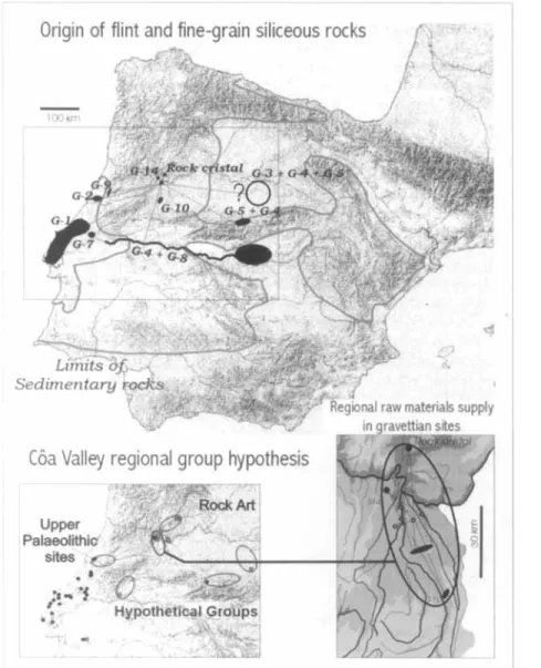
Lithic resoiirccs of the C8a basin sites are he- ing studied (Aubry et al. in press), by system- atic regional surveys and comparisons with archaeological materials. The raw materials not identified through survey are subject to petro- graphic thin-section analyses, which then di-
rect new surveys.
The 1 Jpper Palaeolithic: lithic industries are primarily made on quartzite, quartz and, to a lesser degree, rock crystal. The use and displace- ment of quartz and qiiart7ite in Gravettian sites has been described near the flint sources of the Kio Maior region (ZilhBo 1997; Thacker 2000). In all cases, these three categories oonstitute nearly 99% of the weight of the lithic assem- blages. The two principal raw materials are lo- cal and were transported a few kilometres. The rock crystal is of 1oc:al origin in the Late Gla- cial assemblages, and was transported from the mouth of the Sabor valley, at least 25 km to the north, during the Gravcttian. Other categories of hydrothermal silicifications, detected dur- ing surveys and absent in the alluviums of Caa, come from a maximum range of 50 k m in the CAR and other parallel river basins.
The different types of flint possess petro- graphic and palaeontological characteristics that indicate a siliceous epigencsis of carbonaceous sediments that cannot be found in the region (Aubry ~t ul. in press). The systematic: surveys carried out based on these data indicate scv-
era1 geological sources and regional origins. While this evidence demonstrates human move- ment over approximately 50,000 sq. kin, the precise nature remains to be defined. The first hypothesis of flint expeditions is not supported by the geographical diversity of sourres (FIG-
IJRE 10). Two other different systems of resource exploitation can be proposed; in the first, the
C6a basin would have been sporadically frc- yuented t)y several human groups originating from a region in which flint resources are lo- cated: in the second, a local group would havc been joined by othrrs at seasonal aggregation sites, or rxchanged raw materials (FIGURE 10).
The exploitation of lithic resources of me- diocre quality, originating from a distaiicc of less than 50 km (black rock crystal, G-10, (2-14 and G-15, FIGLRE
lo),
at all sites during all phases of the Uppei Palaeolithic, suggests the pres- ence of a group that exploited a territory of approximately 500-2000 sq. km. The exploi- tation of territories of this size has already been attested by flint material distrilmtion in cen- tral Portugal (Zilhso 1997b). Moreover, the as-sociation of different types of flint at granitic: plateau sites, in a low density, which we inter- pret as short-term, logistical occupations related to the seasonal presence of water, more strongly
74 THIERRY AUBRY, XAVIER MAN(:ADO LLACH, JORGE DAVID SAMPAIO & FARID SELLAMI
FIGURE 10. Flint and fine-gruin siliceous
rocks discarded in
the Gruvettion sites of
the CBtr Valley and hypothesis of territories exploited b y regional groups during the Upper Palaeolithic.
supports the second hypothesis and suggests the existence of associated residential sites. We have not yet analysed the exploitation of re- gional resources through the spatial distribu- tion of sites in different ec:ologir:al contexts, considering the factors influencing artefact preservation, intra-site spatial analysis, char- acterization of local movements of raw materi- als and the variability of abandoned lithic tools. Throughout all of the Upper Palaeolithic, there arc clear differences in the occupation o f
valley and plateau. For example, during the Gravettian, sites are distributed throughout different environments (FIGURE 5). Lithic as- semblages on the plateau are associated wj th
large (lxl.5 m) accumulations of cobbles or frag- ments of heated quark and quartzite. The ori- gins of regional raw materials during this phase
(FIGURE 10) show movements along the C6a and between the valley bottom and the plateau, where the density of lithic assemblages, the high proportion of microlithic projectile points and their discard after utilization, indicate special- ized hunting camps. Conversely, the final Gravettian level of Cardina I, along the vallcy- liottom, is a dense circular deposit, c. 4 m in di- ameter, of heated quartz, rhiolite, granite and quartzite pebbles, particularly placed in 30-cm deep holes. One of these is bordered by slabs and containing numerous charcoal micro-fragments.
OPEN-AIR ROCK-ART, TERRITORIES AND MODES OF EXPLOITATION IN THE COA VrZJ.T.EY (PORTUGAL) 7 5
These data suggested a frequent re-occupation of the same spatially delimited area, interpreted as a hut. The heated materials arc associated with retouched tools essentially composed of quartz scrapers and broken backed bladelets.
Discussion
Allowing for preservation factors, the distribu- tion of sites and lithic raw materials indicates the exploitation of territories on a local and regional scalc, and ofrcgions up to 200 km away. While several arguments seem to favour the hypothesis of a regional group exploiting a ter- ritory of a spatial range of about 50
km
(Aubryet al. in press), at least during the final Gravettixi and final Magdalenian phases, the full pattern remains to be precisely de-tined.
In the Ocrcza basin, a tributary on the right bank of the Tagus valley, along the Sabor, a tribu- tary on the right bank of the Douro, the recent discovery of stylistically similar engravings indicates, as attested by flint remains, a large- scale social network extending over the cen- tral Iberian Cordillera. This network probably rcgularly exploited territories of less than 1000 sq. km
The preserved engravings show a clear geo- logical limit, but the geologically caused pres- ervation of fracture surfaces cannot alone explain the preferential location of engraved panels with numerous superimposed, pecked motifs at the limit of the CBa floodplain. These principal ensembles of engravings are found on tlie right bank of the watercourse where, due to tectonic activity, the panels produced by the destabili- zation of blocks face south arid accumulate heat during the day.
Thc discovery of an engraved panel covered by occupation layers at Eariseu, and picks in a Gravettian layer (layer 3) at Olga Grandc 4, al- low us to attribute some of the pecked engrav- References
ALIBRY, T. 1998. Olga Grande 4: urna sequ6ncici do Palcolitico
superior no planallo mtrc o Rio C6a e a liibeira de Aguiar. Revisto Por~rigriesu de Arqoeologia 1(1): 5-26,
2 m . Uoccupnliuii LLC la basse vallde du C6a pendant le
P'albolithique superieur, in Zilhao et al. (ed.): 253-73.
In press. Le contexte archhlogique de I'art palbolithiquc i l'air libre de la vallQe rlu CAR, irr A c f e s dri c:ulloquc Kart PolAolitliiqne 6 l'oir libre. Le Puysage nioitifid por I'image. Tuutavel-UampBme, 7-9 octobre 1999. Perpignan: Presse Universitaire de Perpignan.
AUBKY, T. 8r A.M. BAPTIST.\. 2000. Une datation objoclive de
l'art du CAa. Lo Recherche, Hors-serie no. 4, Novenihre
20110, La riuissancc de I'art: 54-5.
ings with similar morpho-technical characteris- tics to a phase of Solutrean or Gravettian. At Fariseu, the top of Layer 7 is associated with the base of the engravings of the panel 1 at this site, The density and type of lithic: materials found in this layer do not indicate a long-term
occupation of this part of the site. Nonetheless, the covering of the entire available surface with superimposed lines, and the recurrent geomorphological location on meanders of this type of representation, in association with less rich panels higher on the slopes and visible
from these locations, suggest an association with undated and defined human occupation activi- ties on floodplain erosiorial deposits. Mean- while, we must he cautious in generalizing from this interpretation of panels with numerous superimposed, pecked motifs to the full ensem- ble of Palaeolithic engravings of the C6a val- ley, and in particular to the small. iiicised motifs whose spatial distribution is distinct.
The ancient seasonal hydrological regime of water reserves and flow appears to he very dif- ferent from the present day, as a result of win- ter snow cover. This model. independently confirmed by tlie first ~riicromorphological study of granitic site deposits ahovc 500 m, affects the availability and exploitation of resources in tlie CBa Valley and Iberia itself during the last glacial period.
More data on the preservation of different categories of remains, absolute dating, micro- morphology, the activities behind lithic: a blages and a better definition of the exploited territories will improve our interpretation of thc opcn-air symbolic representations in the Upper Palaeolithic.
Acknowledgements. We thank Paul Bahn, Joiio Zilh5o a n d the two a n o n y n i o ~ ~ s rcfcrccs for their stirnulalirig arid critical reading of the manuscript.
ATJHNY, T. & M. G,AK(:IA DIEZ. 2001. Actualitd sur la chronologie
I:I l'inlcrprhtion de l'art de la vallee du CBa. LesNouvelles
de 1'ArchL:ologic 8 2 : 52-7.
AIJBRY, 'Y., X. MANGADO, J.M. F~jLLOLA. L. ROSELL& J.D. SAMP;~KI.
In press. Raw- material procurrment in the i11~1ierP~~lc:ulitliic settlements of the COa Valley [F'urtugol). New data con-
cern ing I I ~ U L ~ W of resources exploitation in Iberia. Ab-
stract, Gth annual meeting of the E A A , 10-17 Septemher
2000. Lisbon.
BAPTISTA. A . M. 1WB;t. N u tempo serri tempo. A orte dos mpdorr:s pulcolitico do I/ale do CBa, Centro Nacional do Artc Kupestre, Vila Nova de Foz CBa: Parqire Arqueologico do CAa.
76 THIKRRY ALJBRY, XAVIER ILIAN(:AIIO LLACH. JORCE DAVID SAMPATO & FARID SELLAMI 1999b. 0 cir:lo artistim quaternirio do Vale do Cba. Corrl
algumas considerqdes snbre RSI ilns. valora@o ostetica e cruno-estratigrafia figurativa. ilrkeos, pcrspectivas em didlogo [A.R. Criiz R. T.. Oostcrbcck (coord.], i9 Curso Intensioa tli? A r k Pri'-Histbrica Europeia. Tomn 11) 6: 197- 277.
2001. 'The Quateriiarv Rock Art of the C6a Vallcp (Portu- gall, in ZILIIAO ET AL. (t11.1: 237-32.
hWTIST,"i, A.M. & M. GOMES. 1 99s. Arte rupestre do Vale do
C6a 1. Canada do Inferno. Prirnciras irnpressdes, Trabalhos dr Antropologiu ( 7 h'tnologia 35(4): 349-422.
1997. h i e Rupr!strc, in Lilhtio (199ia): 213-406.
R~IINAKIK. K. 1995. The CBa petroglyphs: an nhitiiary lo 111c
stylistic dating ofPalaenlithic rnrk-art. iIniiyuityG9: 877- 82.
BOYD. G.. W. B R I > ~ . c c ~ ~ I < , S. J I I H N S E N . J. hfChk4NlIS. L. LABEVRIES,
J. JOIXEL & G. BUNANI. 1993. Correlation between climate
records froir; North Atlantic sediments and Greenland icc, 'Vature 3 6 5 : 143-7.
UROWN, A.G. 1YY7. Alluvia/ geonrrhnei~/o~.v:(ootlfJluin archurl- ology and e i ~ v i ~ o n m r n t o l change. Cambridge: Cambridge University Prws.
.x.
CHAIJVIkKE. 1. DLCIIANEZ & S. TYMIJT.A. 2000.Qninta da Barca Sul. Intenention4 arrli6ologique 2000. Rapport d'activitA, 1.P.A.
CAKVAI.HO. A. 1999. 0 s sitius de Qucbradas e de Qninta da Torrinha (Vila Nova de Foz CBa) e o Neolitico antign do
Uaixo C6a. Revisto Portuguesa de Arqueologirr, 2(1) 1999:
39-70.
C O i i ~ s l i i O . A.M. & F. KEHELII, 1996. Carta geomurful6gica do Vale do Cda a jusante de Cidadelhe. Cadernos de Grografia 15: 11-33. Coimbra F.L.U.C. ,
UAVEAL-, S. 1971a. La glaciation de la Serra de Estrela. Finisterra, Kevista Portuguesa de Geo,yrafia \'I: 11. Lishon. 1Yi1b. Memdrio d o Centro dr Estudos Ceugrrijicos. n " 3 .
Lisboa.
D'ERRICO. F., M. \7.ANHAb.l<t:N. M.F. SANl:HI..L GOSI, 1:. CROUSSET,
D. 2001. L o s possibles relations
la variabilit6 climatique rapide laciaire, in I.-N. Barrandon. P.
Gibert & V. Michel (ed.). Actes d u Colloqup 'Dntntions XXI" Reiicontres In ternationa
d'Antibes' 19-21 0CtOhI.F: 211
hPDC,%.
nilKh, R. I. 1997. Cunstriiining thc age o l the CBa vallcy (Por- tugal) engraving with radiocarbon dating. Antiquity 71: 105-15.
FLRRLIRA, A.B. 1993. Manifestqhes geoniorfologicas glaciarcs
e periglaciares em Portiigal, in 0 Quaterriririo erii Porlri- gal. balunGo e perspcctivus: 75-84. Lisbon: Colibri. P'ERREIRA U,s SILVA, A. & M.-L. KInEIRO. 1991. Carta geoldgica
dePortugoi. Nnticia explicatioa da folha 15-A. Vila Nova
de Foz CBa. Lisbua, Servibus Genl6gicos dc Porlugsl. CI\~(:iA DIEZ, M. & T. AIJBRY. 111 press. Crafismu niiieblc en u l
Valle de C6a [Vila Kova de Foz C6a, Portugal): la estacion arqueologica de Fariseu. Zephyrus.
GTTY, E. 2000. Des 6cnles artistiques au PakBolithique?. Lrr Re- cherche, Hors-s6rie 4. Novemhre 2000: 60-fil.
JOHNSEN, s.]., 1i.B. CLhUSEN, W. U.\NSGAAKD, K. FUHRER, N .
J , JOIJZEL, f(.
STAUFFER & J.P. STEPPESTSEN, 1 9 9 2 . Irregular glacial interstadials in a new Greenland ice core, ,Vatwe, 359:
311-13.
I.AMHERT, R. 199fi. GPogrophir d u cycle d e i'eau. Amphi7 G6ographio. Tuulouse: Presses [Jniversitaire rlii Mirail.
M ~ i t : i i s , J.E. & P.F. QIII.:IKI~IL. 1993. 0 s estndos de vegetaqtio quakrii;iria cni Portugal; contextns, h a l a n p s rle resultarlos. perspectivas, in 0 ()uatcmdrio ('rn Portugol. bn1un~:o o
perspectivas: 105-31. Lisbon: Colibri.
MERCIER, N.. H. VALLADAS, L. FROGET, J:L. TOKONS, I.-L.REYSS
& T. AI:HKY. 2001. Application d e la methode de la
thermoluniinesceiice h la datation des occupations
GL-NDESTRLTP. C.U. HAMMER, P. IVERSEU,
pal6olithiqnes de la vallee rhi C6a. IK ZILHAO E T A L . [ED.). 2 7S-80,
MONTEIRo~RUllK!cLlES. S. 2000. A esta@o nenlftica dn I'ra7o (FrPixo de Numtio - Norte de Portugal) n n C . ( J l l t P X ~ l > do
Neolftico antigo do norocste peniilsular. Algurnas
consideraCoes preliniinarcs, Aclns d o 3" Congrcsso dc Arqueologia Prnirrsirlur. Vila rc!ul, 22-26 de Setembro de 1999, Vnl Ill. PI CAP.
ADI, P. l'AR.ASOV, M. RIIILLE. J.L.
I l t RAIILIEIT. S . UOTTEhlA 8 v. ANDRIEI.. 1998. Climatir rvconstruction in Europe for 18.000 yr Hi' f l T J I l 1 p1111ei1
data. Qnatcrnarq; Research 4Y: 183-96.
Maximum ages of the CAa valley (Portugal) engravings
measured with Chlorine-36. Antiqiiif.v 71: 100-104,
POPE, G.A. 2000. Weathwing nf pelroglyphs: dirwt assessment a n d jiiip1ic~iLiuii.s lor dating methods, Antiquity 74: 833-
43.
IUBEIR(1, O., H. LAUTENSACH h S. D.&\'h\u. lCICJ4. Geogrofin d r Portugal. Vol. 11. 0 Ritmo Climdtico R n pni,sagmi. 2nd
edition. Lisbon: EdiqBes Jotio SB da Costa.
SACCIII. D. 2000. The impact nt reiieiil dincoverics on our knowl- pdge of rock art oI tho European Palaeolithic. The He-
V E P ~ ofArchacolagy 21(1): 8-15.
SELLAMI, F. 1999. Reconstitution de la dynamique des sols des terrasses rle la Dnrdogne h Crey (bergcrawis). 1 1 t i p ~ t ~ I
siir la cnnservation des sites arc ologitltics dc ploiri air. ThBsr dc dur:torat. 1NA-Paris-Grignon.
2000. Depositional and post-depositional soil evolution and
the inferred environmental conditions of open Palrolithic sites at C6a Valley in Portugal. Ahstrat I . E A A 6lh Ail-
nual Meeting, Lisbon, 10-1 7 Srptenilier 2000.
T.sYLOR, K. 1999. Rapid climate change. Arnerir-on Si-ieriiis 8 7 :
THACKILR, P.T. 2000. 'I'hc rt:li:vanc:o uf rcgional analysis for Upper PnleolithiL archaculugy: A casc study from Portugal, in C.L. Peterkin & 1I.A. Price (od.), llegional approaches to adoptation in late Pleistocene western Europe: 25-45. Oxford: Archaeopress. British Archaeological Reports International series S8YB.
VAI.LAU.AS. H.. N. MwwtK,L. FKC-II,KI., J.L. I C I K I I ~ S , J.I.. R ~ Y S S & T. AI!BK\r. 2001. TL dating of 1Jpper P a l ~ n l i t h i r S i l e s in Ihr COa Vallcy (Purltigal), Qriafemury Suerice Rrviews WATCHMAN. A. 199G. A rcvicw of the theory and assumptions in the AMS dating of the Foz C6a patroglpphs, Portugal. Rock Art Research 13(1]: 21-30,
Z I L H ~ I . J. 1995. The age of the Cba valley (Portugal] rock-art: vahdatiun nf arrhaenlngical dating to the I'alaeolithic and refutation of 'scientific' dating tu historic or pruto-his- toric times. Antiquity 69: 883-901.
(Cnorrl.) 1997a. A I ? ~ Rupestre ePrP-Historin d o Vole d o C6o.
~ i i b d l i u s dr 1995. 19W. Relatnrin Ciantifico an Gioverno
da Rcpilblica portuguesa elahorado nos termos da resoliirio
do Conselho de Ministros nu 4/9fi, de 1 7 de Janeiru Lis-
bon: Ministerio da Cultura.
1997b. 0 Pakoli'tico superior da Estremadura Portuguesa. Lisbon: Colihri.
'Les premiors horrirrir:.~ i n f ~ d e f ' i i ~ s de /a !'i4/1iri.qii/e l/J6riqilP',
Vila Nova dc I:oz COa, 22-24/10/ 1998, Trciholhos d r Arqueologia 17. Lisbon.
GOLIES & J. h,lEIRELES. 1997. The rock art of the C:Ba val- ley [Portugal] and its archaeological context: first results
of current research, Journal of European Archacnlugy 51
1: 7-4Y.
ZILHAI). J.. T. A L I H K Y , A. CARWLHO, G. ZI%MBI;]O B F. ALMEIDA.
1995. 0 sitin arqueol6gico paleolitico do Salto do Boi (Cardina, Sanh Coinha, Vila Nova de Foz CBa). in Actas do Iy Congrcsso dc Arqueologia Peiiirisular: Trohniiios d e Antropologia e Etnologiu 35(4).
PEYROK, 0.. J. ~ ~ i l l l ' l ' ,
PHILLIPS. F.M., F. M O K T C O ~ ~ L K Y , D. ELMORE & I? S H A K b I . l9q7,
320-z 7.
20: 939-43
ZILKqtio, J , , T, AUBRY &A. CAKVAI.HO (ed.]. 2001. /Ii-frS dll clJ//OqLle