Araraquara Railway Heritage: the mobility of industries and identities. Fernanda de Lima Lourencetti - PhD student at Évora University/CIDEHUS
fernanda.delima@gmail.com Abstract
The aim of this article is to enhance the Estrada de Ferro Araraquarense value as an industrial heritage of the mobility through the systematization of the Araraquara (Brazil) industrial heritage by an inventory. The most recent Directive Plan of Araraquara (2014) added to its agenda the dissemination of the urban heritage knowledge in order to make the population to understand a part of its identity, thus, the inventory proposal that will be presented aims to attain this goal. The role of the railway in the city of Araraquara is inseparable of its history, morphology, economic and social development. In the cities of Estrada de Ferro Araraquarense (E.F.A.), the stations were located outside of the existing urban grids, which resulted in a second centrality by the attraction of different kind of services and infrastructures. In this way, the railway of Araraquara, the first city of E.F.A., was important to the consolidation of the territory, industries and cities of the western region of São Paulo State. Currently, Araraquara has its railway infrastructure in the process of deactivation, a big part of it is already abandoned, only the train station passed through a conservation process and became a museum, but even this building does not seem to be part of the daily life. Therefore, the goal of this paper is to present the inventory as a tool to highlight the importance of the preservation of a railway heritage in the urban and regional scales to instigate initiatives able to reintegrate this industrial heritage in the urban grid.
Introduction
This paper had support of CIDEHUS1 – Centro Interdisciplinar de História,
Culturas e Sociedades, which aids advanced cross-disciplinary researches and ensure the
dissemination of knowledge in the academic and other kind of communities. This proposal is a part of a master thesis2 and it intends to disseminate some knowledge about a railway heritage that left territorial marks a long of its way, caused by the dynamic that this way of mobility provides to the places where its infrastructure is installed.
We shall begin this article presenting an important historical detail, the reason why this railway line is called Estrada de Ferro Araraquarense. This name is not an attempt to make a tribute to anyone or to anyplace, it was given because Araraquara was the first city of this railway line, due to its economic importance to the development of a part of the west of São Paulo State. This city was one of the doors to the “pioneer zone” (Monbeig, 1998) of São Paulo State during the hinterland exploitation period, between the end of the 19th century and the beginning of the 20th century. Araraquara had been the railway final point for almost twenty years, which provided to the city a big economic development, rendering it a “regional capital” (Monbeig, 1998).
Despite the fact that the first railway tracks of Araraquara (1885) had been financed by coffee producers, the region developed many other kind of rural products, like the cotton and the cattle. Therefore, since the early start, its importance is linked to goods transportation from the Araraquarense region to the Port of Santos. At the beginning, the train was used to transport people too, but with the passing time and the decline of the railway infrastructure in the country, its use became basically the transportation of products only.
However, the railway infrastructure has always attracted many industries and immigrants. In the past, many railway workers and businessman went to the city and raised new urban services and industries to supply the basic requirements of the population growth. Thus, the railway journey tags the Araraquara and a part of São Paulo State territorial progress.
1CIDEHUS - UID/HIS/00057/2013 (POCI-01-0145-FEDER-007702)
2 The master thesis was written during the Master Erasmus Mundus TPTI (Techniques, Patrimoine et Territoires de l’Industrie), between 2013 and 2015, directed by Prof.ª Ana Cardoso de Matos (Évora University) and by Prof.º Adalberto da Silva Retto Júnior, (Universidade Estadual Paulista “Júlio de Mesquita Filho”, Campus Bauru). The reseach was financed by Association pour l'histoire des chemins du fer - Rail & Histoire, between 2014 and 2015. LOURENCETTI, Fernanda de Lima, “ESTRADA DE FERRO ARARAQUARENSE IN THE FRAMEWORK : The industrial landscapes of the West of São Paulo State as a heritage of the mobility”;
Railway and the State Hinterland
The Araraquarense region is located between Araraquara and Presidente Vargas, that is, it is an area of the west of São Paulo State, which starts in the middle of the State and ends on its limit. The land clearing of this region started after the discovery of gold nearby Cuiabá, a city in Mato Grosso State, and the first settlers of Araraquara date of 1811 (Lança, 2009). Therefore, when the coffee got to the region (1870) followed by the railway (1885), the settlement already existed. This order of arrival happened to almost all the cities which received the Araraquarense Railway infrastructure.
Since 1886 (Barcellone, 2009), the cities of São Paulo State started to develop, the distance between them caused the creation of different kind of local services. The cities of Araraquarense region emerged before the railway arrival, but their legal recognition and real development began after the inauguration of their train station, which attracted many industries and immigrants. During the end of the 19th century, after Araraquara railway inauguration, around forty cities were registered, but between 1900 and 1910, when the railway was facing a slow progress, the number of documented cities decreased. When the railway progress speeded up again, around 1934, more urban centers were legally recognized, but the most significant period was between 1937 and 1938, when the railway almost got to the State limit. All this progress was a reflex of the population and deforestation increase, followed by the railway expansion.
Image 1 - Map of municipal divisions.
Departamento de
Estatística do Estado de São Paulo. São Paulo/1889.
The dark mark is
Araraquara. Adjusted by the author. Source: Arquivo Público Digital do Estado de São Paulo.
During the beginning of the São Paulo State urbanization, in the end of the 19th century, the agriculture was the main economic sector of Brazil, and São Paulo State had the country most intensive economical-industrial development. The leading product was the coffee, which entered the State in 1836 (Barcellone, 2009), twenty-two years before the railway. Only around 1870 (Pacheco, 1988) this product got to Araraquara region, followed by the railway, which arrived to Araraquara in 1885. The coffee price declined around 1897 (Cano, 1975), during the railway fast progress period, so, in 1907 (Cano, 1975), the coffee lost its position in the industrial economy forefront to the railway.
Image 2 - Map of municipal divisions.
Departamento de
Estatística do Estado de
São Paulo. São
Paulo/1930. The dark mark is Araraquara. Adjusted by the author. Source: Arquivo Público Digital do Estado de São Paulo.
Image 3 - Map of municipal divisions.
Departamento de
Estatística do Estado de
São Paulo. São
Paulo/1950. The dark mark is Araraquara. Adjusted by the author. Source: Arquivo Público Digital do Estado de São Paulo.
Image 4 – Industrial expansion of the west region of São Paulo State in 1915 and 1920. These maps can illustrate the coffee evolution followed by the railway. Adapted by the author. Source: Arquivo Público Digital do Estado de São Paulo.
However, after the coffee economy decrease, the railway progress deaccelerated. Only in 1918 (Cano, 1975) the coffee price increased again, and even in a slow progress, the railway kept following it. Between 1932 and 1935 (Monbeig, 1998), when the railway growth speeded up, the Alta Araraquarense region had the cattle as its economic bases. During the 1950s some new economic strategies were provided to help the industrial progress. Among other facilities, the industries could get credits easily and pay low taxes to import industrial equipment. During this industrialization, the railway maintenance and construction high prices caused debts and losses accumulation, thus, the support given to the automotive development increased and the railway lost its sovereignty in the national frame.
Railway and Araraquara Development
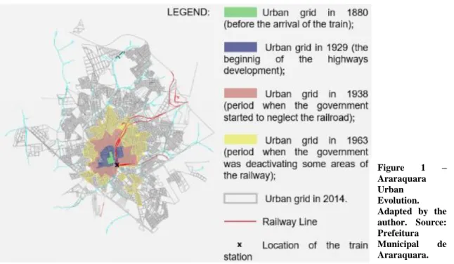
After the construction of the train station in Araraquara, the first urban center (1817) started to grow in its direction. Some neighborhoods were built in the opposite side of the railway so, in 1909 (Barcellone, 2009), a tunnel and some bridges were built, providing the construction of warehouses and workshops. From 1910 to 1929 many requests to install new industries were made; the railway was responsible for attracting them3. The population growth caused the construction industry expansion, which was
responsible for 18% of the industrial jobs in 1945 (Pacheco, 1988). Since then, the industries started to move from the inside to the outside of the city, being closer to the
3 According to Pacheco (1988), until 1935 the railway had 390 workers and in two years this number increased to 422;
highways. Between 1962 and 1976, an Industrial District and many popular neighborhoods were built, which accelerated the city division during the 1970s.
Until, March 15, 2001, the Araraquara railway received passengers’ wagons, but since then, it started to be used only to transport goods. Currently, the urban tracks were deactivated, because a detour was built. However, the railway has continued to attract industries, in 2014 (Piacentini, 2014), the company Randon, railway wagon and semitrailer producer for the transportation of sugar-cane, announced that it would create two thousand jobs and invests R$ 500 million to install an industry in Araraquara, because of its strategic location and all the infrastructure that already exists. A year later, in 2015 the Ibayou CLK, a factory of air conditioning for trains, was inaugurated, and the Hyundai Rotem, a train producer, was inaugurated in 2016, both of them are South Korean (Piacentini, 2014). Figure 1 – Araraquara Urban Evolution. Adapted by the author. Source: Prefeitura Municipal de Araraquara.
Figure 2 – Araraquara Railway path. Red line: old track. Dark blue: currently track. Adapted by the author. Source: Prefeitura Municipal de Araraquara.
Accordingly, these industries are located closer to the new railway tracks, and they attract immigrants and other small services, as happened during the passing time. Since the railway arrival, the immigrants, who has been attracted by the railway, were able to develop many kind of urban services and industries, which are a part of the Araraquara identity. Unfortunately, these industrial heritages are disappearing, so to enhance the railway value, the inventory proposal intents to highlight the Araraquara industrial and urban heritages, making clear the participation of the railway in the city spatial, economic and social identity.
Heritage and Identity
The expression “urban heritage” (Choay, 2002) was used for the first time by Gustavo Giovannoni, an Italian engineer who studied in a course of history of medieval and modern art and became an effective member of the Association Artistic and Cultural of the Architecture of Rome. He wrote “Vecchie città ed edilizia nuova”, in which he presented the relationship between the old city and the new kind of urban planning. As such, the creation of an industrial inventory is a proposal which aims to start the collection of the urban heritage of Araraquara to improve the railway heritage value, putting its participation in the development of the urban drawing in evidence.
Renata Campello Cabral, a Brazilian professor of the University of São Paulo, published on the virtual magazine Vitruvius, in May 15, 2015, an article about the dimension of the urban heritage in the Athens Charter, which was the first actual step to the preservation of urban heritages. The author presented how the historian Françoise Choay put in contrast two concepts, the “urban tradition” and the “technical changes”, which are connected to the territory development by the ways of circulation.
Thus, as a way to connect the “urban heritage” of Giovannoni and the role of the mobility in this field quoted by Choay, the Italian architect Vittorio Guido Zucconi is mentioned by Cabral too. Zucconi defends that to develop an urban heritage preservation, it should be followed three steps: - the first one should be the elaboration of a thesis, which would be able to present all the problems and lost that the old city passed through; - the second part should present a comprehension of the urban expansion, which would show the differences between all the urban planning developed along the years and how they coexist; - as the last step, the result of a synthesis of all the theory in a urban planning should be found to be able to unify all the city history.
These ideas give support to the inventory proposal, turning it into a tool to understand the urban expansion, to protect its heritage and to keep its identity alive during the development of a new urban planning. Araraquara is a part of a big amount of cities reached by E.F.A., a big part of the west region of São Paulo State had this connection, some of them already lost its remaining and others have the railway infrastructure totally neglected. This currently situation means that the comprehension of this case of study is just the start point to understand the territorial consolidation of the west part of São Paulo State. This knowledge should be highlighted to show the inhabitants that the train was and still is important to the cities life.
The first urban heritage built in Araraquara was a church and the square where it is located. During the whole history of the city many other religious and institutional buildings, public places, industries and private habitations were built according to its period and society. Unfortunately, many of these constructions were already replaced or reformulated; some of them can be found in a calamity state. Therefore, the inventory is a way to diffuse information about this concern and to find out new knowledge about the community development. The valuation of the Araraquara railway as a heritage of the mobility depends on the population, the Government and investors interests. Thus, the systematization of the urban heritage can improve the railway value and prevent it of being forgotten or erased of the urban grid.
Inventory Proposal
The industrial and urban heritage inventory of Araraquara was initiated to instigate the systematization of information to make it able to be posted in a virtual museum. To produce the first data sheets were used many researches made by the Theme Project Saberes Eruditos e Técnicos na Configuração e Reconfiguração do Espaço
Urbano – Estado de São Paulo, Séculos XIX e XX4, financed by FAPESP - Fundação de
Amparo à Pesquisa do Estado de São Paulo, coordinated by Prof. Adalberto da Silva
Retto Júnior. Besides these researches, many magazines and other kind of digital sources were used.
As a reference, the French inventories were analyzed. This referential choice was made because the railway infrastructure was always a big concern to France, since its
4 I made part of this group in 2009. My research was entitled A legislação e seu processo de difusão na circulação dos preceitos higiênicos e inovações técnicas na re-configuração das cidades ferroviárias do oeste paulista.
beginning, the major part of the railway system is well managed, developed and preserved, and this country was also the pioneer in the inventory field. Therefore, the files produced are able to introduce some industrial and urban heritage to retell a part of the history and spatial development of Araraquara. Furthermore, the inventory is able to show the heritage situation along the city territory consolidation, and, if it were extended to the other cities, it would recover a part of the State industrial legacy.
Final Comments
This paper presented an inventory proposal able to give some support to the protection of the railway heritage of Araraquara through a cross-over between the mobility, the territorial consolidation and the shaping of the city identity. The development of a documentation like that can crosscheck the information that brings, in terms of knowledge, the relationship between the railway, the territory and the society. In short, to restore a knowledge with the purpose of optimize the diffusion of it, can help the comprehension of the urban development, which can raise some good advices to the reflection about the reintegration and reuse of a railway heritage.
References
MONBEIG, Pierre. Pioneiros e fazendeiros de São Paulo – Editor Hucitec e Editora Polis – São Paulo/1998;
BARCELLONE, Wilson Lopes. O avanço da indústria no oeste paulista: O
Ramal Ferroviário da Alta Paulista, Alta Araraquarense, Noroeste, Sorocabana – I.C. –
UNESP/2009;
CANO, Wilson. Raízes da concentração industrial em São Paulo. – Doctoral Thesis – UNICAMP/1975;
CHOAY, Françoise (org.). La Conférence d’Athènes sur la conservation
artistique et historique des monuments (1931). Paris, Les éditions de l’imprimeur, 2002;
LANÇA, João Felipe de Almeida. Praças e jardins do oeste paulista. A
configuração e transformação do espaço público com a introdução da ferrovia: Ramal da Araraquarense – I.C. – UNESP/2009;
MONBEIG, Pierre. Pioneiros e fazendeiros de São Paulo – Editor Hucitec e Editora Polis – São Paulo/1998;
PACHECO, Carlos Américo. Café e Cidades em São Paulo: Um Estudo de Caso
da Urbanização na Região de Araraquara e São Carlos, 1880/1930. Master's thesis –
UNICAP/1988;
PIACENTINI, Patrícia. A história do desenvolvimento industrial de Araraquara: de 1920 a 2014. Kappa Magazine, edition 91, nº 1, August 19, 2014;
Digital Sources
Arquivo Digital do Estado de São Paulo (2015) - http://www.arquivoestado.sp.gov.br/site/;
Prefeitura Municipal de Araraquara (2015) - http://www.araraquara.sp.gov.br/ Home/Default.aspx;