Procedia Technology 16 ( 2014 ) 342 – 354
ScienceDirect
2212-0173 © 2014 The Authors. Published by Elsevier Ltd. This is an open access article under the CC BY-NC-ND license (http://creativecommons.org/licenses/by-nc-nd/3.0/).
Peer-review under responsibility of the Organizing Committee of CENTERIS 2014. doi: 10.1016/j.protcy.2014.10.100
CENTERIS 2014 - Conference on ENTERprise Information Systems / ProjMAN 2014 -
International Conference on Project MANagement / HCIST 2014 - International Conference on
Health and Social Care Information Systems and Technologies
Development of an agricultural management information system
based on Open-Source solutions
Tiago H. Moreira de Oliveira
a*, Marco Painho
a, Vítor Santos
a, Otávio Sian
a, André
Barriguinha
aaISEGI, Universidade Nova de Lisboa, 1070-312
Abstract
A common problem associated with ready-made software is that businesses are forced to alter some of their processes in order to fully utilize the product. On the other hand, custom-made applications are specifically designed to accommodate the needs of the client’s activities, so the final product will be based on their input during the software development process, and will be fine-tuned to fit the way your business operates. With this approach, an information system designed towards the management of agricultural properties, the Agrifootprint system, was developed.
The main goal of the Agrifootprint system was to develop and implement a Web-based Geographic Information System, based on Open-Source technology, with a custom-made, comprehensive and user-friendly geospatial system, in order to integrate and manage data from several small agriculture enterprises.
The development process was based in Agile methodologies: SCRUM and Evolutionary Prototyping. This option for agile development process brought the establishment of a relationship of complicity between the customer and the development team due to more real understanding of the requirements raised and the system that will be produced from these.
© 2014 The Authors. Published by Elsevier Ltd.
Peer-review under responsibility of the Organizing Committees of CENTERIS/ProjMAN/HCIST 2014
Keywords: Geographic Information Systems; Agricultural information systems; Module View Controller; Agile; SCRUM; Evolutionary Prototyping
* Corresponding author. Tel.: +351-213-828-610; fax: +351-213-828-611. E-mail address: [email protected]
© 2014 The Authors. Published by Elsevier Ltd. This is an open access article under the CC BY-NC-ND license (http://creativecommons.org/licenses/by-nc-nd/3.0/).
1.Introduction
The processes for access and use of information and technology by individuals and organizations as a whole constitute the Information Technologies and define the main foundations of what is currently named the Information Society [1]. Castells points out that we are in a society whose economy is dominated by a technological paradigm in which information is its raw material. That is, the information is critical to the day-to-day organization of all the different tasks that constitute their work processes. It is expected that a relationship exists between the effective management of organizations and how they treat and manage information [2]. Gonçalves states that people, information and knowledge are key assets that differentiate organizations, and success is increasingly the result of the ability of its management [15]. Find the best ways to do this management requires a proactive and persistent attitude in the pursuit of improving posture, which includes having openness to innovate.
Information technologies has been of utmost importance in Geospatial management. In the last years we've seen the growth of a special relevance to the agricultural Information systems.
This importance is reflected in the implementation of systems for the processing and handling of agricultural land and products and the use of information systems to influence agricultural productivity. It can help to take better decisions regarding land, labor, livestock, capital and management. Agricultural productivity can undoubtedly be improved by relevant, reliable and useful data, information and knowledge. Hence, the creation of agricultural information (by extension services, research, education plans and others) is now often managed by agricultural organizations that create information systems to disseminate information to farmers so that farmers can make better decisions in order to take advantage of market opportunities and manage continuous changes in their production systems [6].
In this article, in a more limited aspect, we describe the implementation of an innovative system architecture for the management of agricultural properties which allows a more agile and efficient land and crop management, aiming towards an enhanced productivity and competitiveness.
The Agrifootprint system allows us to build a strong, feature-rich management system for every available and applicable property and its cultures. The user uploads the geographic representation of a unity’s parcels and then assigns a culture for that parcel. The system keeps track of the expenditure and resources consumption, as well as the resulting products of the given parcel, for the given period of time. Reports can be generated in several formats, making it easier to control and manage production costs. Graphical representations of data from the cultures are also added to the reports so the user gets a more immediate view of the plantation’s information.
2.Information systems in the management of agricultural properties
Röling defines an agricultural information system as a system in which agricultural information is generated, transformed, consolidated, received and feedback to underpin knowledge utilization by agricultural producers [25]
To Demiryurek an agricultural information system consists of components, information related processes, system mechanisms and system operations. The analysis of the agricultural information system in a specific farming system may provide the identification of basic components and structure of the system, the different sources of information used by different components in the system, the understanding of how successfully the system works and how to improve system performance [5].
Information systems have an increasingly crucial role to play in improving the operation of land administration in making information and services more readily available in support of land markets and urban and rural economic development. Land administration is providing key information reference information, such as property addresses and transportation networks, which enables the integration of wider spatial information systems managed by the public and private sectors [29].
Land evaluation can be defined as the process of assessing the potential production for various land uses [2]. This approach is based on the matching of qualities of different land units in a specific area, with the requirements of actual or potential land use [22]. The land evaluation results should be useful for rational land use planning [8].
Since making decisions based on geography is basic to human thinking, GIS could be defined as a technological tool for comprehending geography and making intelligent decisions based on space and location [12 ,14], by handling
and addressing the “where” type of questions about spatial phenomena. GIS, has been around before the Internet, and can be described as a system of hardware, software, and procedures that capture, store, edit, manipulate, manage, analyze, share and display georeferenced data [10].
From routinely performing work-related tasks to scientifically exploring the complexities of our world, GIS gives people the geographic advantage to become more productive, more aware, and more responsive citizens [7, 11].
Nowadays, GIS are playing an increasing role in agriculture production throughout the world by helping farmers increase production, reduce costs, and manage their land more efficiently [12]. While natural inputs in farming cannot be controlled, they can be better understood and managed with GIS applications such as crop yield estimates, soil amendment analyses, erosion identification and remediation, predict outcomes and improve business practices. GIS applications is also useful in agriculture, since it can reduce farm input costs, such as fertilizer, fuel, seed, labor and transportations, additionally, farm managers can use GIS to submit government program applications, simplifying what used to be time-consuming multistep processes [14].
However, GIS applications have some issues and limitations to small agriculture enterprises, since it requires a great financial effort in terms of GIS software user license (which is expensive), cost data, either in terms of purchasing existing digital data, in carrying out digitizing, or in setting up and maintaining data gathering systems. These costs could be unpredictable at an early stage, which makes the actual value of utilizing a GIS is difficult to establish. Another issue, for small enterprises, is related with the fact that GIS softwaretypically do not have “user-friendly” interfaces and its usability could be difficult to non-GIS-users, which demands an investment in specialized human resources, requiring expertise and know-how in using GIS applications [20, 30].
These factors, point out that there is failure to initiate or sustain the additional effort to fully implement a GIS. Nevertheless, there is still a huge problem with explaining and describing the potential that a GIS has to offer, and their benefits to this specific area. This is due to the intangible nature of the advantages, the fact that the system is quite complex, and the difficulty in many areas of acquiring the systems' prerequisites [24].
On our approach, and due to our client specifications and requirements, we deployed a fully-customized GIS application based on internet solutions and technologies, the Agrifooprint system. The Internet changed everything, and its application in Geographic Information Systems is no exception. WebGIS may be defined as the combination of the Web and GIS, and it has grown into a rapidly developing discipline since its birth in 1993 [10]. Nowadays, GIS has turned into a compelling Internet application that has prompted many people to take advantage of the Web [18].
The Agrifootprint system was developed according to our client needs, taking inherent advantages over traditional desktop GIS, namely: Easy to use for end users; large number of users; better cross-platform capability; low cost
solution, which doesn’t require software licensing costs, or human resources specialized training; unified update; custom-made tools, designed specifically to the client needs; unique interface, which helps its usability.
3.The development process
The development process was based in Agile methodologies: SCRUM and Evolutionary Prototyping. SCRUM is characterized by small work teams, organized so as to optimize communication and make greater sharing of knowledge. Is an adaptive process for technical or business changes, characterized by a split development packages , testing and documentation contained performed according to the evolution of the project , generates software " deliverables " at any time [28].
Evolutionary Prototyping is as a technique that allows the validation, evaluation and demonstration of the software that was been developed. The use of prototypes allows the stakeholders to follow the development from the beginning to end, when the system is fully developed, to validate data entries and placement of fields on the screens, among other details [23].
This option for agile development process brought the establishment of a relationship of complicity between the customer and the development team due to more real understanding of the requirements raised and the system that will be produced from these.
4.System Technological Architecture
As stated before, the main goal of the Agrifootprint system was to develop and implement a Web-based Geographic Information System with a custom-made, comprehensive and user-friendly geospatial system, in order to integrate and manage data from several small agriculture enterprises.
During the first steps of the development process of the application, the team executed a system analysis and requirements, according to the client everyday needs. To pursue this goal the team promoted an assessment, with interviews, in order to review the client’s specifications, and also to specify the system in terms of its strategic objectives and required functionalities, design and usability.
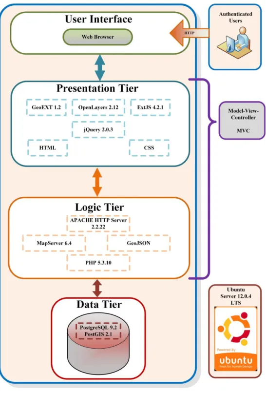
The implemented system architecture (figure 1 and 2), it’s a typical three tier architecture, entirely based on Open -Source technology, and therefore does not involve licensing costs, which is an enormous advantage, since it cuts off the cost for payment of annual licensing. This Open Source solution still allows the development and deployment of a truly interoperable and fully functional web-based GIS application.
WebGIS systems usually present a multi-tier client-server architecture in which data presentation, processing and storage are logically separated processes. This type of architecture allows a greater system modularity in which several software components are selected/developed according to the inherent needs of a specific tier and, therefore, improve the overall maintainability and sustainability of the system. For such reasons, the implemented system architecture is based upon a 3-tier client-server architecture. Moreover, only Free and Open Source Software (FOSS) was considered when selecting the different components to fulfil each tier with the necessary functionalities [16].
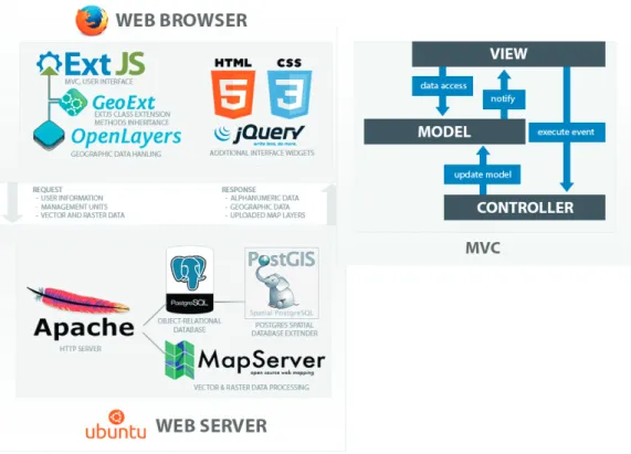
Fig. 2. Client-server communication and ExtJS MVC Structure
The system is based on the server operating system, Linux Ubuntu Server edition (version 12.0.4 LTS). This FOSS Unix-like computer operating system is based on the Debian GNU/Linux distribution, which focus on usability, security and stability. It is composed by many software packages most of which are distributed under a free and open source software license. Additional functionalities can be easily acquired through the installation of additional software components that are mainly available under the Ubuntu Software Center.
Agrifootprint database was implemented according to PostgreSQL (version 9.2) and its spatial extension PostGIS (version 2.1). PostgreSQL, is a robust advanced FOSS object-relational Database Management System (DBMS) that provides several features comparable to those of traditional proprietary DBMS such as Oracle and IBM DB2. Its development started in 1986 at the University of California and, since then, it has earned a strong reputation for reliability, data integrity and correctness. PostgreSQL is fully ACID (atomicity, consistency, isolation and durability) compliant and fully supports the implementation of primary/foreign keys, complex query execution, triggers, views and multiversion concurrency control (MVCC).
The database spatial extension is provided by PostGIS, which states as FOSS software extension that spatially enables the PostgreSQL DBMS by providing support for geographic objects and thus, allowing it to be used as a backend spatial database for GIS applications. Its development started in 2001 by Refractions Research and it is in compliance with Open Geospatial Consortium (OGC) Simple Features Specification for SQL. It also supports several geometry types, topology, data validation, coordinate transformation, networks, routing analysis and several programming Application Programming Interfaces (API). Further developments are mainly related with full support for topology, networks, raster and three-dimensional surfaces.
development of the World Wide Web (WWW) as it has been one of the most popular web servers since 1996. Requests are handled by this open source HTTP server. There are several active services present on the server ready to process any possible entry, whether to obtain a set of images or transforming a vector shape into a database record.
As a Web Mapping Server application, Agrifootprint system is based on MapServer (version 6.4), which is a FOSS C/++-based server software that allows the sharing and editing of geospatial data over the web. Its development started in the mid-1990’s at the University of Minnesota, and is generally addressed as one of the best OS map server solutions
nowadays. It was built in great compliance with OGC’s open standards and specifications which is contributing to a great flexibility and interoperability in map creation and data sharing. It already implements the WMS, WFS and WCS standards. One of its main strengths is the full implementation of the WFS-T protocol, which is essential to achieve spatial data editing capabilities over the Web. Moreover, several extensions were developed that greatly improve its reading and publishing capabilities such as: connection to a wide range of both proprietary and FOSS DBMS, chart symbolizers, several input and output formats for vector and raster data (through OGR and GDAL libraries) and great integration with external desktop applications, such as Google Earth. Aside from shapefiles, it is possible to upload additional geospatial data in several other formats, such as GPX or KML, or even Raster files. Processing of these files is done by MapServer, a platform for publishing spatial data on the web. MapServer takes advantage of libraries such as GDAL for reading and writing raster geospatial data formats, and OGR, which is part of the GDAL source tree, providing a similar capability for handling vector data [17].
On the logic tier, PHP (version 5.3.10) was used as a general-purpose server-side scripting language that was originally designed for the development of dynamic web pages. Its development started in 1995 and it is released as free software. The use of such language will provide the necessary server functionality for complex query execution to the central database allowing the development of specific KPI Dashboards and reports. This scripting language is flexible, powerful, and general-purpose language best suited for web development.
As soon as requests arrive, Apache connects to the PHP file, which then decides whether to start a database process
or any other service present on the server. Both alphanumeric and geospatial data related to Agrifootprint’s management unit’s properties are stored on an open source PostgreSQL object-relational database. The processing of these geographic objects is possible thanks to PostGIS, a spatial database extender for PostgreSQL [4, 21].
Finally, at the presentation tier level, there were used several FOSS JavaScript libraries: OpenLayers (version 2.12), ExtJS (version 4.21), GeoExt (version 1.2) and jQuery (version 2.0.3). Through the use of such language and libraries, it is possible to develop a highly-customized WebGIS solution that is simple to use and meets all the customer needs. OpenLayers is FOSS JavaScript library for displaying spatial data in a web browser. MetaCarta started its development in 2005 and, since then, OpenLayers has attracted an incredibly strong developer community. This library is providing an API to build rich web-based geographic applications that support the majority of OGC’s open standards (WMS, WFS-T, GML, SLD). Furthermore, integration with WorldWind, OpenStreetMaps, Google, Yahoo and Bing services is easily achievable and is providing a worthy source for base cartography data (satellite imagery, street networks) [27].
ExtJS is a dual-licensed (both FOSS and proprietary) cross-browser JavaScript library for building rich Internet applications (RIA). It provides a consistent core user interface and interaction library containing several widgets such as windows, grids, tabs, forms and charts that are allowing the development of desktop-like web applications.
On the client side, every rendered component and interaction is handled by the browser’s JavaScript interpreter.
The ExtJS framework can be considered the backbone of the application, responsible for most of the user interface,
DOM event’s listeners and MVC implementation. Additional tools and plugins from the popular JQuery library were
also added to enrich the interface [26].
We’ve chosen ExtJS for its structure and consistency, as it considerably improves scalability and ease of
maintenance of the application, backed up by a solid architecture. The best way is to follow certain conventions and define application views, models and controllers before actually implementing them.
Forms, tables, charts, map panels and basically every other interface element are placed on different views. The model can be considered a runtime repository, managing the data structures that are accessed by the views. ExtJS also packs a Store class that encapsulates a client side cache of Model objects. Stores load data via Proxy, and also provide functions for sorting, filtering and querying the model instances contained within it. Ultimately, the controller is the logical decision point that will retrieve, build or modify a Model based on the required action. It is also possible to handle triggered events that comes from the views. Multiple models and views can be connected to one or several
This approach allows for the reutilization of a single tool on several situations, anywhere on the application. For instance, every map panel found in Agrifootprint comes from the same view, but are then handled by different controllers, according to the needs.
As stated before, Agrifootprint’s geographic information module is built upon the OpenLayers library, which allows us to perform a fair amount of operations on geospatial data. OpenLayers and ExtJS are brought together by another
library called GeoExt, an extension of ExtJS. With the powerful core methods of ExtJS and GeoExt’s custom classes
combined, it is possible to integrate OpenLayers almost to its full extent. Despite being written in the same scripting language – JavaScript - and capable of operating on their own, both OpenLayers and ExtJS have different class systems and methods. GeoExt comes into play and creates a new instance of the required OpenLayers object, making it fully accessible via ExtJS. The new object can take advantage of thousands of new methods, as it is now considered a native ExtJS component. Combining all these libraries allows for the creation of powerful desktop style GIS apps on the web with JavaScript.
Every interactive map added to the application provide an almost out of the box geospatial data display capable of all sorts of filtering and styling of the loaded layers. OpenLayers is responsible for managing this type of requests and for the contextualization and organization of the received data.
GeoExt is another FOSS Javascript library that is combining the geospatial component of OpenLayers with the user interface components of ExtJS and thus, allowing for the development of powerful desktop like GIS applications on the Web.
These frameworks/libraries also come with methods for managing browser’s requests, which reduces the amount
of time dedicated to handling common network errors, giving the developer a certain level of abstraction and allowing
him to focus on more complex and specific work. As they’re being constantly updated, these open source libraries
provide a trusted source to keep up with the latest web standards.
At the end of the design, development, programming and implementation of the system, there was provided a first version to be tested by users before pursuing to the fully fledged system.
5.Results: Agrifootprint system & application
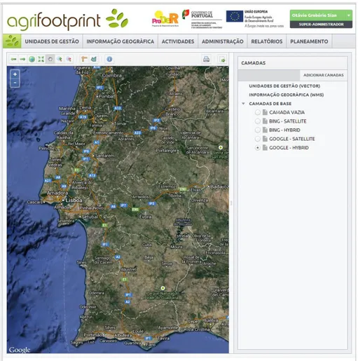
Fig. 3. Agrifootprint System main menu.
The main purpose was to provide the client with a system that contains essential information to support the management of their agricultural activities, along a “user-friendly” and simple interface that improves the performance of companies/farmers through the optimization of the management of information resources and their use in decision support. Users should interact with the application via internet browser, with the WebGIS that provides all the information, stored in a geospatial database, in a graphical interface and set of spatial analysis tools designed specifically for this purpose and client. The implemented detailed geospatial database allowed an appropriate data collection, processing and storing system in order to keep information up to date. This solution also contains the capacity to share, analyze and generate high quality geospatial data and reports.
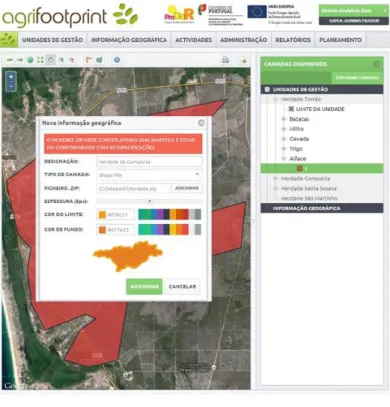
Fig. 4. Upload Module.
Fig. 6. Search and filter Module.
6.Conclusions
The Agrifootprint system with its integrated, centralized and web-accessible database of spatial and related alphanumerical data, allowed non-GIS-users to Perform CRUD (Create, Read, Update and Delete) operations of both spatial and alphanumerical data, by using near real-time data, and also allowed spatial and alphanumerical analysis through the use of maps, charts, tables and KPI (Key Performance Indicators) Dashboard, and produce preformatted reports.
Information system like the one that was developed, are built in accordance to customer requirements from the very beginning and include our last research results in the field, which results in far fewer complications that arise in comparison to the commonly seen ones in ready-made software [19]. Custom business applications are equipped with features that only the client requires which makes it incredibly easy to use, requiring little training to learn how to use the software, being easy and inexpensive to maintain.
The development of a custom-made application and its interface required a stringent examination, in order to verify the correct comprehension, analysis and exact implementation of thoughts of the client into the definite product. Some future work, could include the development and implementation of a mobile application designed towards geospatial data collection to update the Agrifootprint database, with a complete and customized interface.
References
[1]. Almeida, J.M.G. (2007) "Construir o Futuro..." in: Sociedade da Informação - O percurso Português, J.D. Coelho (ed.), Edições Sílabo, Lisboa, p. 708.
[2]. Beek J. (1978) Land evaluation for agriculture development ILRI. Publication 23. Wageningen
[3]. Castells, M. (2004) A Galáxia Internet: Reflexões sobre Internet, Negócios e Sociedade Fundação Calouste Gulbenkian, Lisboa,. [4]. Corti, P., Vincent Mather, S., Kraft, T., Park, B; PostGIS Cookbook; Packt Publishing (January 24, 2014)
[5]. Demiryurek, K. (2000). The analysis of information systems for organic and conventional hazelnut producers in three villages of the Black Sea Region, Turkey. Unpublished doctoral dissertation,University of Reading, Reading, UK.
[6]. Demiryurek, K., Erdem, H., Ceyhan, V., Atasever, S. & Uysal, O. (2008). "Agricultural information systems and communication networks: the case of dairy farmers in Samsun province of Turkey". Information Research, 13(2) paper 343. [Available at
http://InformationR.net/ir/13-2/paper343.html]
[7]. EARL, R. et al (2000) The Potential role of GIS in autonomous field operations. Computers and Electronics in Agriculture, 25; [8]. FAO. (1983) Guidelines: Land evaluation for rainfed agriculture Soils Bulletin 52 . Food and Agriculture Organisation of the United
Nations. Rome.
[9]. Farming the Future - GIS for Agriculture, Vol 2, Esri Press (2013)
[10].Fu, Pind; Sun, Jiulin, Web GIS Principles and Applications, ESRI Press, Redlands California, 2011. [11].GIS Best Practices – GIS for Agriculture, Esri Press (2009)
[12].GIS Best Practices – GIS for Sustainable Agriculture, Esri Press (2008) [13].GIS Best Practices – US Department of Agriculture, Esri Press (2006)
[14].GIS Solutions for Agriculture – Solutions for production, agribusiness and government, Esri Press (2007)
[15].Gonçalves, R (2005). "Modelo Explicativo das Iniciativas de Comércio Electrónico," Universidade de Trás-os-Montes e Alto Douro, Vila Real
[16].Hazzard, E.; OpenLayers 2.10 Beginner's Guide; Packt Publishing (March 18, 2011)
[17].Kropla, B.; Beginning MapServer: Open Source GIS Development; Apress; 1 edition (August 16, 2005)
[18].Longley, P; Goodchild, M.F.; Maguire, D. M.; Rind; D.W., Geographic Information Systems and Science, John Wiley & Sons Ltd, 3rd Ed., Chichester, 2011.
[19].Marra, M.; Pannell, D.; Ghadim, A. A. (2003) The economics of risk, uncertainty and learning in the adoption of new agricultural technologies: where are we on the learning curve? Agricultural Systems, 75;
[20].McClurg, A. Patricia , & Buss, Alan (2007). Professional Development: Teachers Use of GIS to Enhance Student Learning. The Journal of Geography, 106(2), 79-87.
[21].Obe, R., Hsu, L., Ramsey, P.; PostGIS in Action; Manning Publications; 1 edition (April 28, 2011)
[22].Ojeda-Trejo, Ojeda-Trejo, Enrique (1997) E. Land Evaluation and Geographical Information Systems for Land Use Planning. [23].Pressman, Roger S. (2009) Software Engineering: A Practitioner's Approach, McGraw-Hill Higher Education
[24].Recce, J. David; Sumberg, James; Pommier, Ludovic (2004) Matching Technologies with Potential End Users: A Knowledge Engineering Approach for Agricultural Research Management. Journal of Agricultural Economics, Vol. 55, 1;
[25].Röling, N.G. (1988). Extension science: information system in agricultural development. Cambridge: Cambridge University Press. [26].S. Prakash, A. Kumar, R. B. Mishra, MVC Architecture Driven Design and Agile Implementation of a Web-Based Software System,
[28].Schwaber, Ken. Agile Project Management with Scrum. [S.l.]: Microsoft Press, February 1, 2004