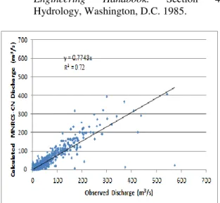
Rainfall-Runoff Modelling using Modified NRCS-CN,RS and GIS -A Case Study
Texto
Imagem


Documentos relacionados
Tendo em vista o avanço nos estudos de estrutura eletrônica, com a construção de superfícies de energia potencial mais acuradas para moléculas poliatômicas, torna-se necessário
Se os computadores e a internet são, hoje em dia, considerados ferramentas fundamentais para o estudo, o desempenho de uma profissão e mesmo para o exercício
This work aimed to measure and analyze total rainfall (P), rainfall intensity and five-day antecedent rainfall effects on runoff (R); to compare measured and simulated R values
Soil gravimetric water content before simulated rainfall application on two soil layers, and time from the start of the rainfall to start the runoff, according to the
Linking geomorphologic knowledge, RS and GIS techniques for analyzing land cover and land use change: a multitemporal study in the Cointzio watershed, Mexico.. Maps of land cover
This study attempts to analyze land use land cover change and its impact on soil erosion process by applying and adopting commonly used satellite remote
Observed and estimated annual runoff with the SAMB (series adjusted on a monthly basis) and the SADB (series adjusted on a daily basis), in bare soil (BS), conventional tillage
The following variables were calculated: rainfall erosivity factor, using the precipitation data; soil erodibility factor, by the correlation between erosivity and soil losses