PRESENTING CULTURAL HERITAGE LANDSCAPES
–
FROM GIS VIA 3D MODELS
TO INTERACTIVE PRESENTATION FRAMEWORKS
N. Prechtel a*, S. Münster b, C. Kröber b, C. Schubert a, S. Schietzold c
a
Institute of Cartography, Dresden University of Technology, D-1062 Dresden, Germany b
Media Centre, Dresden University of Technology, D-1062 Dresden, Germany c
Faculty of Informatics, Dresden University of Technology, D-1062 Dresden, Germany
KEY WORDS: GIS, 3D Visualisation, 3D Presentation Environments, Consistency, Workflow, Altay, Virtual Memorial
ABSTRACT:
Two current projects of the authors try to approach cultural heritage landscapes from both cultural sciences and geography through a combination of customised geo-information (GIS) and visualisation/presentation technology. In excess of a mere academic use, easy-to-handle virtual 3D web presentations may contribute to knowledge, esteem, commemoration and preservation. The examples relate to pre-historic Scythian burial sites in the South-Siberian Altay Mountains (“Uch Enmek”) as well as to a “virtual memorial” of contemporary history (“GEPAM”), a chapter of Jewish prosecution in the “Third Reich”, which historically connects the town of Dresden with the Czech Terezin (Theresienstadt). It is common knowledge that a profound understanding of (pre-)historic artefacts and places may reflect a larger environment as well as an individual geographic setting. Coming from this background, the presented projects try to find technical solutions. They start from GIS models and aim at customised interactive presentations of 3D models. In using the latter a widely-spanned public is invited to a land- or townscape of specific cultural importance. The geographic space is thought to work as a door to a repository of educational exhibits under the umbrella of a web application. Within this concept a landscape/townscape also accounts for the time dimension in different scales (time of construction/operation versus actual state, and in sense of a season and time of the day as a principal modulator of visual perception of space).
*
corresponding author.
1. INTRODUCTION
Until 2000 3D visualization of cultural heritage artifacts was used merely as a digital substitute of physical models (Novitski 1998). Nowadays, 3D models are widely used in a presentation of historic items and structures to the public (Greengrass and Hughes, 2008) as well as in research (Favro, 2006) and education (El Darwich, 2005). In addition, 3D technologies can obviously serve cultural heritage management and conservation tasks, or even their advertising. Most recent case studies aim to present 3D models in a multi-purpose way, which is not at least due to a high effort of their creation. Visual media and communication have found their role in accompanying reconstruction in various stages and, unsurprisingly, in the participation and information of a general public.
Material cultural heritage objects are always related to a landscape, as for instance reflected in the discipline of Environmental Archaeology (O’Connor, 1997). Hard (1970)
analyses the term “landscape” and localizes it within various
connotations:
a) a geographic space of characteristic topography and vegetation (e.g. “mountain landscape”),
b) a momentary visual state determined by weather and illumination (e.g. “early morning summer landscape”) c) a space with affective impact („devastated landscape“), or
d) an aesthetical art-related category (“landscape painting”).
Though back in 1970 not connected at all to computer visualisation, points a) to c) provide a definition framework for landscape visualisation in the sense of a visual model imbedding focus objects into a characteristic geographic setting
along with flexibility in respect to season and weather conditions and hereby creating an affective impact. Since a steadily increasing part of geo-information is available as GIS-data along with extensive analytical processing capabilities, it seems obvious to link them to 3D visualisation under the premises to filter, to translate and to optimise all visually important content with minimised interaction.
2. STUDY SITES AND MOTIVATION 2.1 The Ethno-Nature Park “Uch Enmek”
The Altay Mountains boast with an outstanding cultural heritage. Relics of the once flourishing Scythian culture are ranking highest among the archaeological heritage with the most famous sites being located in the Karakol and Ursul Valley. This has been reflected in a conservation area termed
“Ethno-Nature Park Uch Enmek”. Research and management within this remote area suffer from deficiencies, which are, among others, due to a retarded establishment of information technology, disperse data archiving, and limited access to geo-information. The status quo forms a strong motivation for the project. Presently, the focus of activities is on comprehensive data integration, modelling and presentation of the sites including the surrounding landscape in their present state, but with an envisaged reconstruction for the Skythian period. Archaeological expertise and data for our activities have been provided through a close cooperation with archaeologists from Ghent University, where the working group of Jean Bourgeois is active in the Altay for around 15 years (Bourgeois et. al., 2007). By courtesy of the GeoEye Foundation the Dresden group has received four overlapping IKONOS scenes of the Uch Enmek conservation site forming an important data source. ISPRS Annals of the Photogrammetry, Remote Sensing and Spatial Information Sciences, Volume II-5/W1, 2013
2.2 Historic Dresden and Terezin in the Context of the Shoa
The cities of Dresden and Terezin share a dramatic history through the persecution of Jewish people during World War II. Memorials in both cities allow to commemorate the victims of the Shoah. The purpose of 3D town models in the GEPAM project is to communicate the variety of documents and information concerning the Shoah and allowing the user to evaluate events with regard to the location. Education concerning the holocaust complements the process of remembrance. The target structure of the final presentation environment will allow to access documents and records related to the persecution of the Jews within a web-based city model, and shall serve as a virtual memorial. The GEPAM project is financed by the EFRE scheme of the European Union supporting cross-border cooperation between the neighbouring countries of Czech Republic and Germany.
3. CHALLENGES AND WORKFLOWS 3.1 Information Sources
Landscape/townscape models of the projects are fed from various sources (Hermon, 2008):
a) Topographic data
b) Space- and airborne image data
c) High accuracy surveying of focus objects d) Recent and historic photographs e) Other textural and pictorial sources.
In the present projects, topographic references have been transformed into a customised consistent GIS overview model
depicting the geographic setting (figure 1), in the “Uch Enmek”
study a recent status (comp. Prechtel, 2003a), in the “GEPAM” study additionally a historic one. Models include, among others, a (generalised) relief representation, water bodies, a classified communication network, and principal land use categories. More emphasis is obviously put on architecture in the urban setting of the Dresden/Terezin project. Out of the cited contents, the relief has been conveyed to secondary models like a TIN mesh, in order to receive a contiguous surface representation for the visualisation of all natural and man-made landscape features.
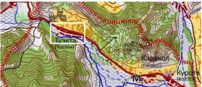
A topographic landscape model will require densification and detailing wherever the primary model appears to be too simplistic for later-on visualisation, what specifically applies to settlements and archaeological sites for being the focus objects. After geometric tuning and pan-sharpening (Cetin & Musaoglul, 2009) of IKONOS satellite images (figure 2), new GIS data layers could be created for Uch Enmek, and existing ones be refined from image interpretation. An archaeological floor plan by the Ghent colleagues (Gheyle et. al., 2008) has been thinned to major objects resulting in a polygon layer of kurgans, and point layer of petroglyphs. A most favourable source for landscape reconstruction was a “GigaPan” mosaic of the village of Tuekta by Stichelbaut, which is not web-accessible any more.
3.2 From a GIS Database to a 3D Model
General concepts of relations between a GIS and a 3D model will determine an appropriate workflow design. If a “rich” GIS basis only serves as a geometric draft for a 3D model, with the latter subsequently emancipating from its predecessor by taking
up various new 3D features, mutual model links will relax and, consequently, analytical capacity will be lost at the GIS side.
Figure 1: Map derived from the “ALTAI 100” GIS contents.
Figure 2: Processed IKONOS image segment showing the village of Tuekta (white box in figure 1).
Close model linkage, however, will be achieved at the expense of reduced individuality. Having obeyed the proposition of close linkage, it will nevertheless be possible to present ways of visual improvement through 3D post-processing in order to mitigate a dominant schematic appeal.
Our workflow from GIS to a 3D model has been implemented using ESRI software at the GIS side and Cinema 4D (C4D) as 3D modelling and visualisation software. It comprises as principal tasks:
1. From 2D consistency to 3D consistency
2. Customising information for transfer to 3D software 3. 3D content generation, refinement and transitions.
Step 1 (2D consistency to 3D consistency): GIS contents should be indicative in terms of a specific, primarily invariant visual 3D representation (functional categories are often not). Another basic demand is a gap- and overlap-free representation of all areal features which are levelled with the terrain. Logical considerations also include the close relation between relief and drainage. Herein hydrologic (=visual) consistency demands, that rivers have a concordant downhill-pointing gradient along the thalweg, which defines the connection of the deepest positions in valley cross-sections. An automated enforcement of this rule has been applied (comp. Prechtel, 2003b). The definition of a DEM inhibits that slopes will appear shouldered with marked gradient changes on opposite edges of a road traversing this slope. DEM resolution constraints may, furthermore, result in oblique cross sections of river beds: Again automated geo-processing steps became necessary, and could secure that river and road contours will bear a (visually) realistic elevation whilst becoming in the same time integral parts of a TIN-based relief model.
Step 2 (Customising information for transfer to 3D software): The GIS data model influences the object structure in the 3D derivate and has to be designed for efficient transfer. One tested transfer option (via VRML) from GIS to 3D modelling software firstly maps surface features onto the TIN representation of the surface. It burns all feature edges into the relief-based TIN. A surface type, or, alternatively, attributes relevant for 3D visualisation, can then be coined to the TIN meshes via a
numeric code called “TIN tag”. The process is exemplified by figure 3 for a thematically simplified geographic subset: Integration of DEM and surface features (subfigures 1 and 2), and resulting surface representations after VRML export (unstructured and tagged surface given by subfigures 3 and 4, respectively).
Figure 3: Transfer of the GIS model to a VRML representation for further processing in 3D modelling software.
In dealing with multi-temporal historic representations on top of a more or less static terrain shape (GEPAM), a multi-step time-driven feature export can concentrate on a subset of altered elements after initial export. Herein, a 2.5D feature structure with a project-centered, uniform datum and a consistent spatial reference system will guarantee a geometric fit of all entities after export.
Step 3 (3D content, refinement and transitions): Within this paper we can only discuss buildings as an exemplary 3D content. We use the 2.5D geometry and coded attributes to implement a solution on the basis of prototypes. A design- and age-wise comparatively uniform building stock of a Siberian village could be reduced to a few principal types. But what works within the latter context appears insufficient in the urban context of GEPAM. Here, a balanced mix between standard buildings from prototypes (low effort) and prominent buildings
calling for individual modelling had to be found. Building typology and footprints can be identified by the colour-tagged
polygons of the “raw” model. The tedious work of adjusting
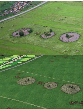
prototype objects to every single footprint could be delegated to a routine, which adjusts a standard geometry to individual footprints and orientations by affine transformation (result in Figure 4). Such a routine has been implemented using a so-called XPresso-Tag in C4D (Schmidt, 2011). The strategy of prototype representations has similarly been used for the Skythian burial mounds (“kurgans”); results can be compared to a photograph in figure 5.
Figure 4: Tuekta in a rendered 3D model.
A typical landscape model will portray a scale-dependent selection of surface objects. In case of functional units there is no evident visual counterpart to a category. Furthermore, various land use/land cover classes are given as aggregations, whereas visualisation calls for disaggregation (e.g. forest to trees). Theoretical concepts which explicitly integrate scale as an additional dimension to space and time have been published (van Oosterom & Stoter, 2010), but are not operational. Another link exists between scale and object transitions: The closer we get the more transition properties become noticeable. How can, for instance, a transition from a gravel road to its vegetated neighbourhood be handled? An example may be given: A road has a convex surface and a low but steep edge. This geometric property can be used to steer the textural transition between road and vegetated neighbourhood (e.g. by a
“falloff shader”). As a result a narrow transition is formed
where some sparse vegetation invades the outermost edges of a road (Schubert, 2013). Likewise, transition between permanently and rarely water-covered grounds along river banks has been geometrically and texturally modulated. The most important decision nodes and principles within the workflow shall be summarised with a reference to the scheme of figure 6:
The GIS landscape model will, along with point or areal representations of cultural heritage objects, form the basis. A data model should right from the beginning be tailored to support upgrades within a 3D modelling environment. The analytically and visually important role of the relief has to be taken into account through a removal of inconsistencies (especially rivers, roads). In doing so only a surface representation, flexible in terms of resolution like a TIN, makes sense. Data volume restrictions, on the other hand, favour a stronger generalisation within less relevant (fringe) zones of the model.
Model complexity is in particular an issue, where on-line applications with a small bandwidth (mobile devices) or limited hardware rendering capacity shall be served.
Figure 5: Kurgans near Tuekta as seen by a real and a virtual camera (aerial photograph by J. Bourgeois, Ghent University, 2007).
Figure 6: Simplified Workflow from GIS to a 3D presentation environment.
The closer the links of initial (2.5D) and secondary model (3D),
the more “design” has to be encoded within the GIS data model and the more prototypes have to be generated and provided. Schematic representations will even after geometric adjustments (comp. above) find their limits, where individual structures constitute the character of a space. Whether individual objects will be eligible for membership in the landmark class or not, is not easily decided and to some degree subjective. But photo-realism within landmark depictions strongly determines spatial orientation and recognition through a direct visual feedback (Hileyz et. al., 2008).
3.3 Upgrade to an Information System
As a stand-alone version a 3D landscape model gives just a visual impression of a landscape. But one fascinating additional opportunity is the inclusion of exterior information into such a model within the context of an elaborated web application. A largely increased versatility of such an upgrade to an interactive information system results from a hyper-linking of defined geographical objects to (controlled) external information retrieval and display, the well-known capabilities of internet applications. Geographic setting and the general looks of objects of interest can be taken from the 3D model, placed in the centre of the application. The displayed geographic setting may suggest indicative object relations within the given urban or landscape context. Spatial exploration may take place in a in a discontinuous way or continuously as a virtual stroll depending on individual preferences. These cited capabilities
can be termed “geographic access”. When now being aided by selective context information, structural, functional, historic, or genetic aspects can be conveyed to a user along with the geographic space. Furthermore, access to this (typically 2D) context information package can be offered by both, a geographic object (the standard case) or a (textual) index search including filter options. Provision of such information complements geographic access and could be termed "library access". Pictorial context may eventually bridge both types when working as a digital magnifier and revealing visual details, which had fallen below the level of detail of the 3D model. Finally, geographic and library access can be augmented
by a third mode, the “temporal access”. After navigating
through a present-state town or landscape, a time slider can be set, which changes the 3D model contents into a display of previous states (normally with reduced reliability). The time slider in particular invokes a virtual feature with no existing real world equivalent.
Contents, structure, navigation within and layout of the context information cannot be discussed in detail within this article. We only stress two aspects: Firstly, a standardised general structure and clear layout of all context display (within balloons) will obviously contribute to the usability. Secondly, potential user groups of an application are undisputedly essential for the concept. To the understanding of the authors, user group orientation basically affects the selection of points of interest and the editorial work on the context contents, whilst the underlying 3D model of the geographic space is - with some reservations by the level of detail - more or less omni-functional.
Coming back to our present projects, three classes of information will be relevant and carry different user interfaces:
1. Intrinsic 3D objects: relief, higher vegetation, buildings, street furniture, obstacles, etc.
2. Additional 3D information: coded thematic overlays (i.e. roadmap, census data)
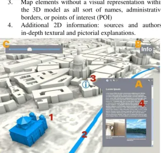
3. Map elements without a visual representation within the 3D model as all sort of names, administrative borders, or points of interest (POI)
4. Additional 2D information: sources and authors, in-depth textural and pictorial explanations.
Figure 7: Information Classes and Instructional Principles.
Whereas the first three classes of information harmonise with a spatial presentation, the fourth group of information will not fit in at all. During the last years and fostered by virtual globes like Google Earth or Microsoft Virtual Earth some common procedures for user interaction inside such information systems have been established (cf. figure 7). As a consequence it is a widely established concept to access information listed in the forth group using 2D pop-up information balloons [A] invoked by clicks on 3D obstacles or POIs. Moreover, 3D information overlays should not permanently be visible, but nonetheless easily accessible in a mostly self-explaining way. In order to fade in such a thematic overlay, a static button is shown in the graphical user interface [B]. A major information component related to (pre-)historic landscapes is the option of temporal transitions: A well-known concept of user-controlled transitions is to implement a time slider [C], which controls the display of items or states as relevant for the user-selected age.
While at this stage a spatial and interactive landscape visualisation has turned into a 3D GUI as a door to spatial and non-spatial information, another major challenge is to motivate users to explore such a virtual world (Schwan, 2006). Promising approaches are, use, for instance, game-like elements as guided tours or thematic storytelling (Pletinckx et.al, 2004) to lead visitors from one point of interest to another.
4. INTERACTIVE PRESENTATION ENVIRONMENTS 4.1 Open Web Globe
In 2011, a novel project, allowing a compilation and publication of interactive 3D landscapes at the base of a virtual globe, went online. The Open Source Software Development Kit (SDK) is
termed “OpenWebGlobe” (OWG), and has been developed at
the FHNW at Basel (Loesch et al., 2012). New technologies and standards like HTML5, WebGL and JavaScript provide the basis. Different from popular applications like Google Earth it enables to process, to implement, and to flexibly present a full set of user-selected geo-data. At the client side it allows PlugIn-free view and navigation. Adequate processing tools calculate resolution pyramids and tiles of the data, in order to manage large data volumes. One pilot implementation was an interactive 3D landscape model from the Ethno-Nature Park “Uch Enmek”, which has been exported from the C4D model as described above.
4.2 Google Earth
Google Earth is a program for the visualization of a variety of geographic content within a virtual globe. It is also available as a plug in for web browsers. In order to represent the earth more in detail, terrain elevation (DEM) can be added as well as pictures of the ground and even building models. The provision of additional information in the form of a balloon for a building, point or area of interest makes Google Earth a valuable tool for educational purposes. A KML file which is an Open Geospatial Consortium standard combines the variety of data e.g. ground overlays, balloons and 3D-models and can easily be imported into the virtual environment. The optional integration of a time slider allows a perception of both historic and topic information on top of the same basic model.
4.3 Mobile Devices
Well-equipped mobile devices like recent smartphones and tablets became popular on the consumer market over the last years. They are ready for 3D graphics and multimedia-based, interactive applications like Augmented Reality. Using these technologies this class of devices can turn townscapes and landscapes into virtual museums, whereas a user can experience 3D models of historical buildings or archaeological objects in-situ, and simultaneously experience diverse associated information in an interactive way. Since the latest releases of mobile browsers already make use of WebGL, the built-in camera, diverse sensors and GPS, this fascinating experience can be provided to a user by customised web-applications using exclusively web technologies without additional plug-ins (Sefferman, 2013; Sawicki & Chaber, 2013): The application retrieves pre-processed 3D models from a server through a transmission of current positional coordinates and orientation of the mobile device.
Nevertheless, some technical challenges concern a smart reuse of existing models by an implementation of Augmented Reality applications (3D): There is few frameworks and engines available allowing a user to address specific platforms independent of the operating system installed on a mobile device. A best practice solution is a use of the HTML5 standard, which already supports a display of camera views along with position and direction information from built-in GPS sensors. The latter, however, will not reliably deliver positional data of sufficient accuracy due to terrain- and time-dependent dependent signal quality variation. Technical solutions for a mostly necessary improvement of accuracy, which is not in the focus of this article, make additionally use of image recognition techniques (Simon et al., 2000; Park et al., 2012). A promising strategy is a use of dominant object contours within stored landscape/townscape models (e.g. a corner of a building complex or a street) together with the instant camera image for a processing by efficient match algorithms. Assuming a rather constant motion and a movie-like image capture, GPS position can even be completely substituted by a detection of closely spaced geo-referenced marker points.
5. CONCLUSION AND PERSPECTIVES Whenever project concepts accept a curtailing of photo-realism for the sake of closely linked information contents, reduced efforts, and a user-guidance to focus contents, solutions can be offered to quite efficiently perform a transition from GIS data to a 3D landscape model. Our studies mostly relied on prototypes: Levelled features receive carefully selected procedural textures. Where real 3D objects are needed, prototypes of vegetation and ISPRS Annals of the Photogrammetry, Remote Sensing and Spatial Information Sciences, Volume II-5/W1, 2013
building objects populate the tagged surfaces. Visual refinements, a domain of 3D modelling, can, for instance, modulate geometric and texture transitions in order to improve visual realism.
Various theoretical ideas and concepts of both projects are not yet fully backed by efficient technical strategies and implementations. To only name some of them: Balancing between landmark and prototype representation, generalisation of objects in respect to spatial importance of parts of a model, detail presentations of individual sites (Plets et. al., 2012) or
artefacts (like grave goods) within a “navigable 3D balloon”, a
standardised and simple transfer of GIS feature attribute sets into interactive 3D environments using various access modes (layer-based or event-based e.g. by mouse position), or a smart modulation of visual landscape properties according to phenological phases or time of the day within an application. A high variety of development environments are meanwhile available for an upgrade of view-only 3D presentations into a web-based presentation environment. However, there exists a lack of standardisation and generic solutions, what results in still high development efforts and workflows, which are optimised for a particular project only.
6. REFERENCES References from Journals:
Bourgeois, J.; De Wulf, A.; Goosens, R. and Gheyle, W., 2007. Saving the Frozen Scythian Tombs of the Altai Mountains (Central Asia). World Archaeology 39, pp. 458–474.
Cetin, M. and Musaoglu, N., 2009. Merging Hyperspectral and Panchromatic Image Data: Qualitative and Quantitative Analysis. Int J. Rem. Sens., 30(7), pp. 1779–1804.
Hard, G, 1970. Die „Landschaft“ der Sprache und die „Landschaft“ der Geographen. Semantische und forschungs -logische Studien, Colloquium Geographicum 11, Bonn. O'Connor, T., 1997. Environmental Archaeology: A Matter of Definition. Environmental Archaeology 2, pp. 1-6.
Plets, G.; Gheyle, W.; Verhoeven, G.; De Reu, J.; Bourgeois, J.; Verhegge, J. and Stichelbaut, B., 2012. Three-dimensional Recording of Archaeological Remains in the Altai Mountains. Antiquity 86, pp. 1–14.
Prechtel, N., 2003a. GIS-Aufbau für den Naturschutz im Russischen Altai. Kartographische Bausteine 21, pp. 82–100.
Prechtel, N., 2003b. Selected Problems and Solutions for Drainage Modelling and Handling in a GIS. Kartographische Bausteine 21, pp. 101–109.
Sawicki, B. and Chaber, B., 2013. Efficient Visualization of 3D Models by Web Browser. Computing - Archives for Scientific Computing (2013), 13 p., DOI 10.1007/s00607-012-0275-z.
References from Books:
El Darwich, R., 2005. Modelle. In: H.-J. Pandel and U.A.J. Becher (eds.). Handbuch Medien im Geschichtsunterricht, Wochenschau-Verlag, Schwalbach, pp. 580-591.
Greengrass, M. and L. M. Hughes, 2008. The Virtual Representation of the Past. Ashgate, Aldershot.
Hermon, S., 2008. Reasoning in 3D: A Critical Appraisal of the Role of 3D Modelling and Virtual Reconstructions in Archaeology. In: Frischer, B., ed. Beyond Illustration: 2D and 3D Digital Technologies as Tools for Discovery in Archaeology, Oxford, Tempus Reparatum, pp. 36-45.
Novitski, B. J., 1998. Rendering Real and Imagined Buildings: the Art of Computer Modeling from the Palace of Kublai Khan to Le Corbusier's villas. Rockport Pub., Gloucester.
Van Oosterom, P. and Stoter, J., 2010. 5D Data Modelling: Full Integration of 2D/3D Space, Time and Scale Dimensions. In: S.I. Fabrikant et al., eds. GIScience 2010, LNCS 6292, Springer-Verlag, Berlin Heidelberg, pp. 310–324.
References from Other Literature:
Favro, D., 2006. In the eyes of the beholder: Virtual Reality Re-creations and Academia. In: L. Haselberger, J. Humphrey and D. Abernathy, eds., Imaging Ancient Rome: Documentation, Visualization, Imagination. Proc. of the 3rd Williams Symp. on Classical Architecture, Jornal of Roman Archaeology., Portsmouth, pp. 321-334.
Gheyle, W.; Goossens, R.; De Wulf, A.; Dvornikov, E.P. and Bourgeois, J, 2008. Archaeological Heritage Management through Aerial Photography and Satellite Images: The Uch Enmek Park – Republic Altay, In: Lasaponara, R. and Masini, N., eds. Advances in Remote Sensing for Archaeology and Cultural Heritage Management, Proc. of 1st Intern. EARSeL Workshop CNR, Rome, Sept. 30 – Oct. 4, Rome, pp. 275-279. Hileyz, H.; Vedanthamz, R.; Cuellarz, G.; Liuyz, A.; Gelfandz, N.; Grzeszczukz, R. and Borriello, G., 2008. Landmark-Based Pedestrian Navigation from Collections of Geotagged Photos. MUM '08 Proceedings of the 7th International Conference on Mobile and Ubiquitous Multimedia, pp. 145-152.
Loesch, B.; Christen, M. and Nebiker, S., 2012. OpenWeb Globe – Ein quelloffenes Software Development Kit zur Entwicklung virtueller Globen auf Basis von HTML5 und WebGL, In: Seifert, E., ed. „Erdblicke – Perspektiven für die
Geowissenschaften“, Publ. der DGPF 21(2012), pp. 275-283. Park, Jo.; Lee, D. and Park, Ju., 2012. Digital Map Based Pose Improvement for Outdoor Augmented Reality. IEEE Int. Symp. on Mixed a. Augm. Reality (ISMAR), Nov. 2012, pp. 309 –310. Pletinckx, D.; De Jaegher, L.; Helsen, T.; Langen, I.; Silberman, N.A.; van der Donckt, M.C. and Stobbe, J., 2004. Telling the Local Story: An Interactive Cultural Presentation System for Community and Regional Settings. VAST 2004: The 5th International Symposium on Virtual Reality, Archaeology and Cultural Heritage. Eurographics Association,pp. 233-239. Schmidt, M., 2011. Landschaft und Archäologie im virtuellen 3D-Modell. Beispiel „Ethno-Nature Park Uch-Enmek“ (Altai, Russland). Dipl. Thesis Technische Universität Dresden, Inst. f. Cartography, superv. by Prechtel, N. and Münster, S., 120 p. Schubert, C., 2013. Verbesserte Graphik und Interaktion für das 3D-Landschaftsmodell des Ethno-Nature Parks “Uch-Enmek” (Altai) unter Verwendung von OpenWebGlobe. Pre-thesis Technische Universität Dresden, Inst. f. Cartography, superv. by Prechtel, N. and Münster, S., 66 p.
Simon, G.; Fitzgibbon, A.W. and Zisserman, A., 2000. Markerless Tracking Using Planar Structures in the Scene. Proceedings of the IEEE and ACM International Symposium on Augmented Reality (ISAR 2000), Oct. 2000, pp. 120–128.
References from Websites:
Schwan, S. and Buder, J., 2006. Virtuelle Realität und E-Learning. e-teaching.org, Portalbereich Didaktisches Design, http://www.e-teaching.org/didaktik/gestaltung/vr/vr.pdf, (last access July, 9, 2013).
Sefferman, I. [curator], 2013. Mobile HTML5. Teaching Developers how to Build Great Mobile Web Apps with HTML5. http://www.mobilehtml5.com/ (last acc. July, 9, 2013). ISPRS Annals of the Photogrammetry, Remote Sensing and Spatial Information Sciences, Volume II-5/W1, 2013