SCRS/2016/056 Collect. Vol. Sci. Pap. ICCAT, 73(8): 2851-2859 (2017)
SHARK RESEARCH AND DATA COLLECTION PROGRAM: PROGRESS ON THE
SATELLITE TAGGING OF SHORTFIN MAKO FOR
POST-RELEASE SURVIVAL AND HABITAT USE STUDIES
Rui Coelho1,*, Andrés Domingo2, John Carlson3, Enric Cortes3,Daniela Rosa1, Philip Miller4 and Miguel N. Santos1,5
SUMMARY
This paper provides an update of two projects developed within the ICCAT Shark Research and Data Collection Program (SRDCP) using satellite telemetry, specifically a study on habitat use and other on post-release survival. At the time of this paper, 10 tags (6 miniPATs and 4 sPAT) had been deployed from observers on Portuguese fishing vessels in the temperate NE Atlantic. The remaining tags are being deployed by USA in the temperate NW and Uruguay in the SW. The preliminary analysis shows that specimens tagged in the temperate NE moved to southern areas, while specimens tagged in the tropical NE close to the Cabo Verde archipelago moved easterly to the African continent. Three tags were deployed in equatorial waters and one moved to the NE while the other moved SE. In terms of post-release survivorship, 2 specimens tagged with sPATs survived and 2 died. For the 2nd year of the project we will acquire additional miniPATs to be deployed preferably in equatorial waters, in the mixing zone for the stocks.
RÉSUMÉ
Le présent document fournit une mise à jour de deux projets menés dans le cadre du Programme de recherche et de collecte de données sur les requins (SRDCP) de l’ICCAT, utilisant la télémétrie par satellite, en particulier une étude sur l'utilisation de l'habitat et une autre sur la survie suivant la remise à l'eau. Au moment de rédiger le présent travail, dix marques (6 miniPAT et 4 sPAT) ont été apposées par des observateurs déployés à bord de navires de pêche portugais dans les eaux tempérées du Nord-Est de l'Atlantique. Les autres marques sont apposées par des observateurs des États-Unis dans les eaux tempérées du Nord-Ouest et de l'Uruguay dans le Sud-Nord-Ouest. L'analyse préliminaire des marques montre que les spécimens marqués dans les eaux tempérées du Nord-Est se sont déplacés vers les régions du Sud, tandis que les spécimens marqués dans le Nord-Est tropical à proximité de l'archipel de Cabo Verde se sont déplacés vers l'Est se rapprochant du continent africain. Trois marques ont été apposées dans les eaux équatoriales et un spécimen s'est déplacé vers le Nord-Est, tandis que l'autre vers le Sud-Est. En termes de survie suivant la remise à l'eau, deux spécimens marqués avec des sPAT ont survécu et deux autres sont morts. Pour la deuxième année du projet, nous allons acquérir des miniPATs supplémentaires à apposer de préférence dans les eaux équatoriales, dans la zone de mélange des stocks.
RESUMEN
Este documento presenta una actualización de dos proyectos desarrollados en el marco del Programa de recopilación de datos e investigación sobre tiburones (SRDCP) de ICCAT, utilizando telemetría vía satélite, específicamente un estudio sobre utilización del hábitat y otro sobre supervivencia posterior a la liberación. En el momento de redactar este documento, los observadores habían colocado 10 marcas (6 miniPat y 4 sPAT) desde buques pesqueros portugueses en el Atlántico nororiental templado. Las marcas restantes serán colocadas por Estados Unidos en el Atlántico noroeste templado y por Uruguay en el Atlántico suroeste. Un análisis preliminar muestra que los ejemplares marcados en el noreste templado se
1 IPMA - Portuguese Institute for the Ocean and Atmosphere. Av. 5 de Outubro s/n, 8700-305 Olhão, Portugal.
desplazaron a zonas meridionales, mientras que los ejemplares marcados en el noreste tropical, cerca del archipiélago de Cabo Verde se desplazaron hacia el este, acercándose al continente africano. Se colocaron tres marcas en aguas ecuatoriales, y una se desplazó hacia el noreste mientras que la otra hacia el sureste. En términos de supervivencia tras la liberación, dos ejemplares marcados con sPAT sobrevivieron y otros dos murieron. Para el segundo año del proyecto se prevé adquirir más marcas miniPAT para colocarlas preferentemente en aguas ecuatoriales, en la zona de mezcla para los stocks.
KEYWORDS
Habitat use, Post-release survival, Research program, Satellite tagging, Shortfin mako
Background
In 2013 the ICCAT Shark Species Group developed the general guidelines of the Shark Research and Data Collection Program (SRDCP), aimed at the development and coordination of science and science-related activities needed to support provision of sound scientific advice for the conservation and management of sharks in the Atlantic. During the 2014 inter-sessional meeting, the Sharks Working Group updated the SRDCP, which was framed within the 2015-2020 SCRS Strategic Plan. The initial 2-year implementation of this Research Program focuses on biological aspects, ecology and fisheries of shortfin mako shark that are relevant to the upcoming stock assessment of this important species.
Quantifying habitat use and migration patterns is important for management of fish populations and conservation planning, as the knowledge of movement patterns (i.e. use of space and activity patterns) is essential in understanding the behavior of a species as well as defining essential habitat for that species. The need to understand whether fish are migrating between regions that can be undergoing different types and levels of fishing activity is also very important. Another important aspect is related with quantifying mortality, that is important for the management of fish populations and conservation planning, as both the natural and fisheries-induced mortality are essential in assessing the population size and the effect that fisheries fisheries-induced mortality have on the populations. However, and even though those issues are of great importance, there is still very limited information on the stock structure of most pelagic elasmobranchs at an ocean wide level, and therefore promoting those types of studies is of utmost importance. Using incorrect assumptions about the stock structure, movements and mortality can lead to biased conclusions about the level of fishing that is sustainable in a given region, and thus information about these processes should be incorporated into stock assessments.
In recent years, and especially due to the advances in the technology, satellite tagging has been increasingly used in several pelagic shark species including Lamniformes sharks in the Atlantic such as the porbeagle, Lamna nasus (e.g., Pade et al. 2009) and the basking shark, Cetorhinus maximus (e.g., Sims et al., 2003, 2006; Shepard et al., 2006; Skomal et al., 2009). By the contrary, the currently available information for the shortfin mako is still very scarce at a global level and almost non-existent in the Atlantic. The most comprehensive study to date was carried out by Abascal et al. (2011) that tagged 9 shortfin makos in the Pacific, while in the Atlantic the only information previously published comes from a study by Loefer et al. (2005) that tagged and analyzed data from only one specimen in the NW Atlantic. Additionally, one specimen has also been tagged in the past in the SW Atlantic by the Uruguay observer program.
Given the wide range of information that can be gathered with satellite telemetry studies, within the ICCAT SRDCP, two specific studies using satellite telemetry were developed, specifically: 1) a study that uses satellite telemetry to gather and provide information on stock boundaries, movement patterns and habitat use of shortfin mako in the Atlantic Ocean; and 2) a study that uses satellite telemetry to determine post-release mortality of discarded specimens. The main deliverables and outcomes expected for these projects are SCRS papers to be presented during the 2017 SMA stock assessment meeting with the final results. Submission to a peer-review journal is also envisioned pending agreement between all participants in the study.
The objectives of this specific document are to present the current development status of both projects and the plans for the next stages during the 2nd year of the project.
Project execution - progress
The list of milestones and deliverables originally developed in the projects proposals and their current development status is provided in Table 1 (habitat use project) and Table 2 (post-release survival). Additionally, given that the Atlantic SMA stock assessment has been postponed from 2016 to 2017, the expected completion dates of the deliverables has been updated to reflect this, giving us more time for the deployment of the tags and completion of the analysis.
The tags acquisition process (mini PATs for the habitat use study and survival PATs for the post-release survival) was completed during October-November 2015 by the ICCAT Secretariat, and the tags were then distributed to the participating Institutes in late 2015. A total of 9 miniPATs and 14 sPATs were acquired with the available funds. Table 3 describes the numbers of tags acquired and their allocation for deployment during the project, as well as the current deployment status.
Currently, 4 tags (2 miniPATs and 2 sPAT) have been deployed from observers on Portuguese fishing vessels in the temperate Northeast Atlantic. Additional tags have also been deployed by national programs and project that are cooperating with this ICCAT/SRDCP initiative (see Table 4, Figure 1). The tag deployment process is expected to be completed by early 2017, in order to provide sufficient time for the data transmissions, data analysis and preparation of the final document for the 2017 SMA stock assessment session.
In terms of movements, at this stage only preliminary analysis was done as some tags are still in deployment mode, and others are transmitting data at this time. As such, only strait line tracks are shown (Figure 2). However, even with this preliminary analysis, it is interesting to note that the specimens tagged in the temperate NE Atlantic (tagged in December and January) moved to southern areas, while specimens tagged in the tropical NE region close to the Cabo Verde archipelago (tagged between August and October) moved easterly to areas closer to the African continent. There were also 3 tags deployed in equatorial waters (December and February), but those are still in deployment mode and pop-up is expected later this year. Finally, the SMA that was tagged in the SW Atlantic off Uruguay moved in the SW direction along the limits of the continental shelf (Figure 2). In terms of post-release survivorship, only preliminary analysis is shown at this stage as only 2 sPATs have been deployed. In both cases the sharks survived for at least the first 30 days after discarding, even though in one case the specimen had severe damage at the level of the gill slits (Table 5).
Project execution - future steps
The main plan for the next phase of the project is to continue the tag deployment during 2016 (and early 2017) in the several regions of the Atlantic. We will also propose to acquire some additional MiniPAT tags during 2016, depending on the available project budget for 2017, for deployment in later 2016 and early 2017. Thereafter, the final analysis and the final SCRS paper (deliverable 5 in the habitat use study and deliverable 4 in the post-release mortality study) will be prepared according to the proposed schedule.
Contribution of SMA satellite telemetry data from other projects
As initially planned, the participating scientists and Institutes in this study have also other ongoing projects and initiatives that also include the deployment of satellite telemetry tags in SMA (see details in Table 4, Figure 1 and Figure 2). Most of those additional tags from these other projects have already been deployed, or are planned to be deployed during 2016 and 2017.
Project LL-Sharks: 10 tags have been deployed on SMA specimens by Portuguese fishing vessels in the tropical NE and equatorial regions within the scope of Project LL-Sharks (Mitigação das capturas de tubarões na pescaria de palangre de superfície; Ref: 31-03-05-FEP-44; funded by PROMAR).
Project MAKO-WIDE: Within project MAKO-WIDE - A wide scale hemispheric and inter-disciplinary study aiming the conservation of the shortfin mako shark in the Atlantic Ocean; Ref: FAPESP/19740/2014; funded by FCT-Portugal and FAPESP-São Paulo, Brazil), we are in the process of acquiring 16 additional tags, of which 10 will be deployed by Portuguese vessels in the NE tropical
Project SAFEWATERS SC7: This project (The provision of advice on the conservation of pelagic sharks associated to fishing activity under EU Sustainable Fisheries Partnership Agreements in the Atlantic Ocean, under the Framework Contract MARE/2012/21, funded by the European Commission) has recently acquired 5 miniPATs for deployment in SMA in the EEZ of Cabo Verde, in the tropical NE Atlantic.
NOAA (US-PRT-URY) collaboration project: Within this collaboration project that involves scientists from NOAA (US), DINARA (Uruguay) and IPMA (Portugal) 9 miniPATs have been acquired by NOAA and are in the process of being deployed in the NW Atlantic. Additionally, one previous tag also from NOAA was deployed in late 2014 by Uruguay in the SW Atlantic.
Acknowledgments
This study was carried out as part of a cooperative work conducted by the ICCAT Shark species group integrated in the ICCAT Shark Research and Data Collection Program (SRDCP). The authors are grateful to all fishery observers and longline skippers from the Nations involved in this study. Tags from additional sources have been contributed and deployed with several national Projects, specifically: Project "LL-Sharks: Mitigação das capturas de tubarões na pescaria de palangre de superfície (Ref: 31-03-05-FEP-44, funded by PROMAR)", Project "MAKO-WIDE - "A wide scale inter-hemispheric and inter-disciplinary study aiming the conservation of the shortfin mako shark in the Atlantic Ocean (Ref: FAPESP/19740/2014)", funded by FCT (Portuguese Foundation for Science and Technology) and FAPESP (São Paulo Research Foundation, Brazil), and Project SAFEWATERS SC7 (The provision of advice on the conservation of pelagic sharks associated to fishing activity under EU Sustainable Fisheries Partnership Agreements in the Atlantic Ocean) under the Framework Contract MARE/2012/21, funded by the European Commission. Additional satellite tags were acquired by NOAA in US-Uruguay and US-Portugal-Uruguay collaboration initiatives. Rui Coelho is supported by an Investigador-FCT contract from the Portuguese Foundation for Science and Technology (FCT) supported by the EU European Social Fund and the Programa Operacional Potencial Humano (Ref: IF/00253/2014).
References
Abascal, F.J., Quintans, M., Ramos-Cartelle, A., Mejuto, J. 2011. Movements and environmental preferences of the shortfin mako, Isurus oxyrinchus, in the southeastern Pacific Ocean. Mar Biol 158: 1175-1184. Loefer J.K., Sedberry G.R., McGovern J.C. 2005. Vertical movements of a shortfin mako in the western North
Atlantic as determined by pop-up satellite tagging. Southeast Nat 4: 237-246.
Pade N.G., Queiroz N., Humphries N.E., Witt M.J., Jones C.S., Noble L.R., Sims D.W. 2009 First results from satellite-linked archival tagging of porbeagle shark, Lamna nasus: Area fidelity, widerscale movements and plasticity in diel depth changes. J Exp Mar Biol Ecol 370: 64-74.
Shepard E.L.C., Ahmed M.Z., Southall E.J., Witt M.J., Metcalfe J.D., Sims D.W. 2006. Diel and tidal rhythms in diving behaviour of pelagic sharks identified by signal processing of archival tagging data. Mar Ecol Prog Ser 328: 205-213.
Sims D.W., Southall E.J., Richardson A.J., Reid P.C., Metcalfe J.D. 2003. Seasonal movements and behaviour of basking sharks from archival tagging: no evidence of winter hibernation. Mar Ecol Prog Ser 248: 187-196.
Sims D.W., Witt M.J., Richardson A.J., Southall E.J., Metcalfe J.D. 2006. Encounter success of free-ranging marine predator movements across a dynamic prey landscape. Proc R Soc B 273: 1195-1201.
Skomal G.B., Zeeman S.I., Chisholm J.H., Summers E.L., Walsh H.J., McMahon K.W., Thorrold S.R. 2009. Transequatorial migrations by basking sharks in the western Atlantic ocean. Curr Biol 19: 1019-1022.
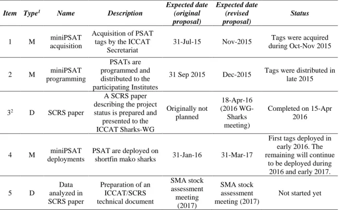
Table 1. List of milestones and deliverables with the respective expected completion dates for the shortfin mako
satellite tagging project for studying habitat use. The differences in the original and currently expected delivery dates are related with the fact that the shortfin mako Atlantic stock assessment has been postponed to 2017. This will provide more time for the deployment of the tags and data analysis.
Item Type1 Name Description
Expected date (original proposal) Expected date (revised proposal) Status 1 M miniPSAT acquisition Acquisition of PSAT tags by the ICCAT
Secretariat
31-Jul-15 Nov-2015 Tags were acquired during Oct-Nov 2015 2 M miniPSAT programming PSATs are programmed and distributed to the participating Institutes
31 Sep 2015 Dec-2015 Tags were distributed in late 2015
32 D SCRS paper
A SCRS paper describing the project status is prepared and
presented to the ICCAT Sharks-WG Originally not planned 18-Apr-16 (2016 WG-Sharks meeting) Completed on 15-Apr 2016 4 M miniPSAT deployments
PSAT are deployed on
shortfin mako sharks 31-Jan-16 31-Mar-17
First tags deployed in early 2016. The remaining will continue
to be deployed during 2016 and early 2017. 5 D Data analyzed in SCRS paper Preparation of an ICCAT/SCRS technical document SMA stock assessment meeting (2017) SMA stock assessment meeting (2017)
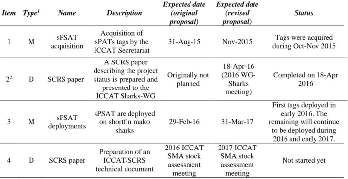
Table 2. List of milestones and deliverables with the respective expected completion dates for the shortfin mako
satellite tagging project for studying post-release mortality. The differences in the original and currently expected delivery dates are related with the fact that the shortfin mako Atlantic stock assessment has been postponed to 2017. This will provide more time for the deployment of the tags and data analysis.
Item Type1 Name Description
Expected date (original proposal) Expected date (revised proposal) Status 1 M sPSAT acquisition Acquisition of sPATs tags by the ICCAT Secretariat
31-Aug-15 Nov-2015 Tags were acquired during Oct-Nov 2015
22 D SCRS paper
A SCRS paper describing the project status is prepared and
presented to the ICCAT Sharks-WG Originally not planned 18-Apr-16 (2016 WG-Sharks meeting) Completed on 18-Apr 2016 3 M sPSAT deployments
sPSAT are deployed on shortfin mako
sharks
29-Feb-16 31-Mar-17
First tags deployed in early 2016. The remaining will continue
to be deployed during 2016 and early 2017. 4 D SCRS paper Preparation of an ICCAT/SCRS technical document 2016 ICCAT SMA stock assessment meeting 2017 ICCAT SMA stock assessment meeting
Not started yet
Table 3. List with the distribution of miniPATs and sPATS by the participating Institutes. Current deployment
status and additional notes are also provided.
Institute
Tag types and quantities (ICCAT/SRDCP tags)
Status of deployment
(ICCAT/SRDCP tags) Additional notes
IPMA,
Portugal 6 miniPATs + 4 sPATS
2 miniPATs + 2 sPATs deployed in Jan-Mar
2016.
Additional habitat PATs (10 PTTs from MIT) from other projects (LL-Sharks)
have been deployed in 2015-2016. Preliminary results are shown in this
document.
NOAA,
US 5 sPATs
ICCAT tags not yet deployed
Additional 9 miniPATs were acquired by NOAA in a collaborative US-Portugal-Uruguay tagging project. Those tags will
be deployed during 2016 in the NW Atlantic.
DINARA,
Uruguay 3 miniPATs + 5 sPATS
ICCAT tags not yet deployed
One additional tag (MK10 PAT) acquired by NOAA was deployed in late 2014 in the SW Atlantic. Preliminary results are
shown in this document.
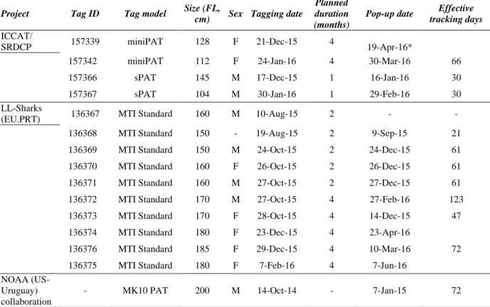
Table 4. Details of the tag characteristics and SMA specimens tagged to the present date. The table shows
information from the tags acquired and deployed directly with the ICCAT/SRDCP project, as well as other tags deployed by participating national scientists and institutes with additional funds from other sources and projects, and that will also contribute for the final analysis.
Project Tag ID Tag model Size (FL,
cm) Sex Tagging date
Planned duration (months)
Pop-up date Effective tracking days
ICCAT/
SRDCP 157339 miniPAT 128 F 21-Dec-15 4 19-Apr-16*
157342 miniPAT 112 F 24-Jan-16 4 30-Mar-16 66
157366 sPAT 145 M 17-Dec-15 1 16-Jan-16 30
157367 sPAT 104 M 30-Jan-16 1 29-Feb-16 30
LL-Sharks
(EU.PRT) 136367 MTI Standard 160 M 10-Aug-15 2 - -
136368 MTI Standard 150 - 19-Aug-15 2 9-Sep-15 21
136369 MTI Standard 150 M 24-Oct-15 2 24-Dec-15 61
136370 MTI Standard 160 F 26-Oct-15 2 26-Dec-15 61
136371 MTI Standard 160 M 27-Oct-15 2 27-Dec-15 61
136372 MTI Standard 170 M 27-Oct-15 4 27-Feb-16 123
136373 MTI Standard 170 F 28-Oct-15 4 14-Dec-15 47
136374 MTI Standard 180 F 23-Dec-15 4 23-Apr-16
136376 MTI Standard 185 F 29-Dec-15 4 10-Mar-16 72
136375 MTI Standard 180 F 7-Feb-16 4 7-Jun-16
NOAA (US-Uruguay) collaboration
- MK10 PAT 200 M 14-Oct-14 - 7-Jan-15 72
Table 5: Details of the sPATs deployed and with data reported at this stage. Fish condition (injuries) is used
according to the ICCAT codes for tagging studies: P = Perfect (no visual damage); M = Moderate (superficial damage); S = Severe (could affect survival); U = Unknow. For ease of interpretation, table cells are color coded as: P (green), M (orange) and S (red).
Tag ID Tag model Size (FL, cm) Sex Tagging date
Fish condition (injuries)
Fate (after 30 days) Global head mouth eyes skin fins body gill
slits
157366 sPAT 145 M 17-Dec-15 M P M P P P P M Survival
Figure 1. Map with the location of the SMA satellite tag deployments for both male and female shortfin mako
sharks (Isurus oxyrinchus). The map shows information from the tags acquired and deployed directly with the ICCAT/SRDCP project, as well as other tags deployed by participating national scientists and institutes with additional funds from other sources and projects that will also contribute for the final analysis (see Table 4 for details).
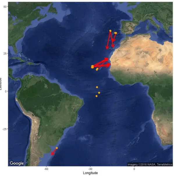
Figure 2. Map with the SMA satellite tag tracks (preliminary strait line tracks). Orange dots represent tagging
locations and the arrows represent the strait line tracks for the pop-up locations. Only partial data is shown as some tags are still deployed and are expected to pop-up in the future and some tags are currently transmitting. The map shows information from the tags acquired and deployed directly with the ICCAT/SRDCP project, as well as other tags deployed by participating national scientists and institutes with additional funds from other sources and projects that will also contribute for the final analysis (see Table 4 for details).