La circulation des fluides dans la croûte induit ainsi des effets importants sur la rhéologie de la lithosphère. La plupart des circulations de fluides et les changements qui les accompagnent semblent synchrones avec la déformation.
Les fluides dans le système Sud Armoricain
Métamorphisme, magmatisme et infiltration d’eau météorique
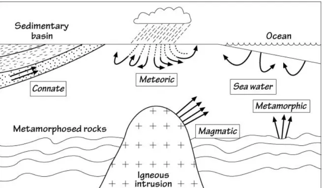
Généralités sur les fluides métamorphiques 1. Origine des fluides
L'excavation de ces roches provoque une chute immédiate de la pression lithostatique, tandis que la pression du fluide dans la porosité reste inchangée. Dans ce cas, la libération des fluides se produit plus tard lors du parcours de la roche à travers la croûte (d'après Wannamaker, 2010).

Les fluides métamorphiques dans le Massif Armoricain
En effet, les données obtenues sur les inclusions fluides et la composition isotopique en oxygène du quartz montrent que les veines parallèles au CSA se sont formées à partir de fluides métamorphiques dans la croûte moyenne, à des températures probablement autour de 400-500°C. Le CSA s'est donc concentré sur la circulation de quantités importantes de fluides métamorphiques et météoriques, en raison de l'augmentation de la perméabilité en réponse à la déformation.
Conclusion
In the Lizio samples, biotite compositions were analyzed in four samples and are presented together in Supplementary Table 2 due to the high homogeneity of the compositions (Fig. 3b). In the field, the soil contact of the Lizio and Questembert granite is not visible, making direct observation of feeder dikes impossible.

The northern and southern branches of the South Armorica Shear Zone (SASZ) are represented (NB and SB) together with Carboniferous granites and quartz veins. 6. Histograms showing the oxygen isotopic composition of quartz veins parallel (a) and oblique (b) to the South Armorica Shear Zone.

Déformation, magmatisme et hydrothermalisme le long du
Cisaillement Sud Armoricain
Contraintes géochronologiques
Massif Armoricain, France)
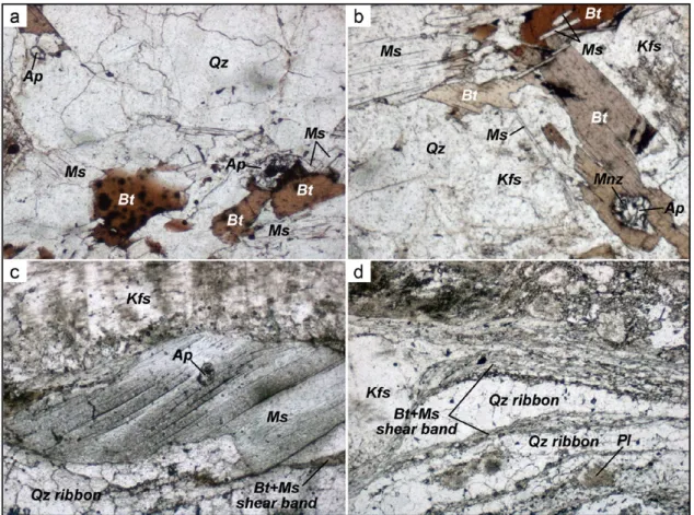
The Lizio Two-Mica granite is emplaced along the NBSASZ (Fig.1b). ThisgraniticMassifishhighlyemblematic because the one due to a singular formation of a singular form (Bepthe 'et a paar, 1979). edduringshearingalong the nbsasz. To summarize, in the Lizio two-micagranite, quartz and feldspar (orthoclase, microcline and plagioclase) represent about 90% of the mineral composition (Fig. 3) while biotite and muscovite remain with 10%, biotite remaining the generally more abundant than an abundant muscovite, and an abundant patients. In undeformed samples, quartz is large and often euhedral (Fig.3a–b), while it is recrystallized in ribbons, undeformed samples (Fig.3c–d).
Fig.4.(a)Muscovite chemical composition shown in Mg-Ti-Nadiagram Milleretal.(1981).(b)Mg+Fe(apfu) vs.Si(apfu)content of muscovites showing the extent of phengite replacement. a)Compositionschimiquesdesmuscovitesrepre´sente´esdanslediagrammeternaireMg-Ti-NadeMilleretal.(1981).(b)TeneursMg+Fe(apfu)vs. BSE images of zircon grains from sample LRT12 revealed unzoned gray cores surrounded by thin darker rims, with no evidence of inherited cores ( Fig. 5d ). When plotted on a Wetherill concordia diagram (Fig. 5c), nine data points define a concordia age of 316.45.6 Ma (MSWD=0.64), identical within error to the number recorded from sample LRT15, but more precise.
A simple 2D thermo-numerical model (details in Appendix A) shows that the Lizio-type granitic pluton, located at mid-crustal depths, cooled by less than 1 Ma (Fig. 8), consistent with this scenario.
Both the K-Ar in the muscovite and the U-Pb in the monazite isotopic systems were hydrothermally reset, while the radiogenic U-Pb system in most zircons remained unaffected and dated to the age of the granite emplacements. Chemical maps of TiO2 content (Fig. 7) were obtained to accurately depict the chemical changes induced by hydrothermal activity. However, as the 40Ar⁄39Ar dates decrease regularly with the increase in hydrothermal character recorded by both the whole rock and the .
This is consistent with the high level of emplacement of the granite along a major shear zone, i.e. rather, we interpret the 316–319 Ma age as the emplacement age of the granite and the younger muscovite 40Ar⁄39Ar and monazite U–Pb datings as results of hydrothermal sub-solidus alteration. Rather, it is the consequence of a liquid-assisted reset of the muscovite K-Ar and Fig. 5 percent of common206Pb versus zircon206Pb⁄238U apparent dates.
Fluid-induced Th-Pb chronometer disruption of monazite: in situ dating and elemental mapping in pegmatites from the Rhodope (Greece, Bulgaria) . Chemical.

Mylonites of the South Armorican Shear Zone: insights for crustal fluid flow and water-rock interaction processes. Cite this article in press as: Tartèse, R., et al., Mylonites of the South Armorican Shear Zone: Insights for fluid flow on Earth's crust and Fig. Cite this article in press as: Tartèse, R., et al., Mylonites of the South Armorican Shear Zone: Insights for crustal-scale fluid flow and sampling table.
Please cite this article in press as: Tartèse, R., et al., Mylonites of the South Armorican Shear Zone: Insights for crustal-scale fluid flow and Whole rock geochemical characteristics. Please cite this article in press as: Tartèse, R., et al., Mylonites of the South Armorican Shear Zone: Insights for crustal-scale fluid flow and. Please cite this article in press as: Tartèse, R., et al., Mylonites of the South Armorican Shear Zone: Insights for crustal-scale fluid flow and stable isotope (O and C) data.
Please cite this press article as: Tartèse, R., et al., Mylonites of the South Armorica Shear Zone: Insights from Crustal-Scale Fluid Flow and Zircon U-Pb Isotope Data.

Implications métallogéniques et tectoniques
Introduction
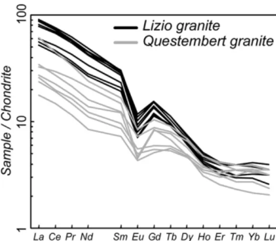
In the Armorican Massif, numerous peraluminous granites were emplaced in different metamorphic units around 320–315-Ma (Bernard-Griffiths et al., 1985; Turrillot, 2010; Tartèse et al., 2011b). In this HHPB, U-rich peraluminous granites were produced by partial melting of such enriched metasedimentary formations (Cuney et al., 1990). This phenomenon, together with the subsequent magmatic differentiation of granitic magmas, constitute two main processes leading to uranium preconcentration (Cuney et al., 1990).
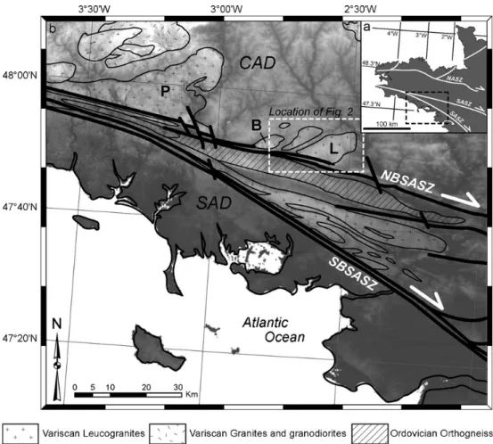
In the Armorican Massif, the South Armorican Shear Zone (SASZ) is a lithospheric dextral wrench zone that separates the Central Armorican Domain (CAD) from the South Armorican Domain (SAD) (e.g., Jégouzo, 1980; Gumiaux et al., 2004a; 2004b ). Along the northern branch of the SASZ (NBSASZ), syntectonic Carboniferous granitoids (Berthé et al., 1979; Bernard-Griffiths et al., 1985; Tartèse et al., in press) intrude the Brioverian basement (Fig. 7.2a) . Circulation of such meteoric fluids in the Armorican crust has been independently documented through a detailed oxygen isotope and fluid inclusion study of the giant quartz veins that crop out along the SASZ (Lemarchand et al., 2011).
In some places along the SASZ, highly sheared mylonites additionally recorded the infiltration of these surface-derived waters (Tartèse et al., 2011a).

Hydrothermal alteration and uranium leaching
73 wt% recorded in Lizio samples, and then a decrease for the SiO2-rich samples from the Questembert granite. This implies a mineral isotopic disequilibrium in samples of the Questembert granite, necessarily caused by some hydrothermal sub-solidus alteration. Only a few types of fluids can be proposed, of which surface water is the most likely, as documented in the Armorican Massif (Lemarchand et al., 2011; Tartèse et al., 2011a) and also in other parts of the area. Variscan Belt during the Late Carboniferous (e.g. Boiron et al., 2003; Vallance et al., 2004).
Considering an initial δ18O value of the meteoric water between -10 and 0‰, the feldspar in equilibrium with this water will exhibit a δ18O value between 22.2 and 32.2‰ at 15°C, by the global feldspar composition of the Questembert granite (Table 7. ) and fractionation factors from Zheng (1993). These calculated values are of course much higher than the values measured in our altered samples (δ18O value of feldspar close to 10-11‰). This corresponds to the shallow depth of emplacement of the Questembert granite, which is estimated to be around 1-2 kbar.
By extension, the leaching of uranium from the Questembert granite, which correlates with the isotopic alteration of the feldspar, must also be related to this solidus hydrothermal alteration caused by the oxidation of surface-derived meteoric water.

Estimation of the quantity of uranium leached
60-90% of the whole-rock uranium content, this proportion increasing with the degree of fractionation of the granite (e.g., Cuney and Friedrich, 1987; Friedrich et al., 1987). These lower Th/U ratios are linked to a decrease in the Th content, due to monazite fractionation (Tartèse and Boulvais, 2010). 7.4, the U content of the Questembert "low-U" samples should have been above this value, at about 15-20 ppm.
Feldspar 18O data show that most of the studied samples of the Questembert granite have been affected by sub-solidus pervasive hydrothermal alteration. In fact, however, approximately 80% of the current surface of the Questembert granite is characterized by ductile SC structures. Overall, the deep deformation of the intrusion facilitated fluid infiltration and therefore uranium leaching at depth.
The shape of the Questembert granite can be approximated to an ellipsoid with a length of 60 km, a width of 10 and Questembert patterns.
Discussion
Considering an initial average U content of 10 ppm in the pluton before modification, the mass of U in the modified part of the pluton was 2.7 x 10⁹ kg. One of the largest uranium ore deposits mined in France is located in the Lodève Basin (#3 in Figure 7.5). Hydrothermal alteration and/or weathering of neighboring U-rich granites from the Carboniferous of the Massif Central have been proposed as a likely source of uranium, in particular on the basis of the study of the Pb isotopic signature of galena (Lancelot et al., 1984 ) and pitchblende ( Lancelot and Vella, 1989 ), together with some contribution from interbedded felsic volcanic deposits, dated to Early Permian age ( Bruguier et al., 2003 ).
Pochat and Van Den Driessche (2011) made a detailed reconstruction of the late Paleozoic evolution of the Graissasac-Lodève Basin. The average U content in the early Permian sediments of the Lodève basin is about 5 ppm (Pagel, 1990). Therefore, the early Permian sediments of the Lodève Basin may contain up to 1,840,000 tons of uranium.
According to these authors, the vast majority of the uranium trapped in this Permian Basin comes from neighboring granite massifs, especially from the Aumance horst.

Conclusion
La carrière Quily permet d'observer l'extension nord du faisceau de veines de La Villeder. Cette altération s'accompagne parfois de la néoformation de larges facettes de monazite (Fig. 8.6c et d). La composition chimique de la tourmaline est étroitement liée au liquide à partir duquel elle a cristallisé.
La composition isotopique en oxygène du quartz et de la cassitérite a été analysée dans plusieurs veines à La Villeder et Quily (Tableau 8.1 et Fig. 8.8). Trois analyses ont été réalisées sur la cassitérite de La Villerder et sont identiques avec un 18O de 5,9‰. Les images MEB montrent que la croissance de la prétulite apparaît plus tardive que celle du xénotime (Fig. 8.16).
Les encadrés représentent l'orientation des veines minéralisées et la contrainte principale de raccourcissement associée, lors des étapes 2 (a) et 3 (b) de la minéralisation de Saint-Aubin-des-Châteaux (d'après Gloaguen et al., 2007). Des granites peralumineux de type Lizio, issus de la fusion partielle de métasédiments, remontent dans la croûte. A l'échelle de la chaîne européenne Varisque, Boiron et al. 2003) ont proposé un modèle expliquant l'origine de la minéralisation aurifère (Fig. 8.26).