The darker young volcanic islands of Palea and Nea Kameni in the center of the caldera. It includes the Italian volcanoes (Lipari, Vesuvius, Etna, Stromboli, etc.), the Hellenic volcanic arc (Methana, Milos, Santorini, Nisyros, etc.) and the volcanoes of the Caucasus-Himalayan belt.
Submarine volcanism
Kolumbo Submarine Volcano
During ROV dives in 2006, a widespread hydrothermal field was discovered on the northern rim of the Kolumbo crater floor (Sigurdsson et al., 2006). In 2010 and 2011, more recent research was conducted at the Columbo Hydrothermal Field.
Historical References of the 1650 AD Kolumbo eruption
The activity continued until the 30th of the same month and after a few days of reduced activity the eruption subsided. Two of the main dangerous effects of this volcanic eruption on the local communities were the clouds of toxic gases that were released.
Study Area
Geodynamic Setting and Evolution of the Aegean Sea
This difference led to the creation of an extensional field in the Aegean plate and the opening of the North Aegean basin. The area of the Aegean Sea has existed since the Early Tertiary, when the molasses basin of Rodopi - North Aegean Sea was formed.
Geodynamic Sectors of the Aegean Sea
The geotectonic position of the North Aegean basin within the plate-tectonic framework of the Eastern Mediterranean. Tertiary sedimentary basins, similar to those of the North Aegean, are absent in this region.
The Hellenic Volcanic Arc – Geodynamic Setting
The volcanic centers of the Aegean Arc are located along the southern edge of the CAP. Topographic map of the southern Aegean Sea, combining onshore and offshore data from recent oceanographic surveys.
Kolumbo Volcanic Chain – Geodynamic Setting
- Christianna
Topographic map of the southern Aegean combining onshore and offshore data from recent oceanographic surveys. The four modern volcanic groups are indicated in red boxes together with the names of the main terrestrial and submarine volcanic centers along the Nomiko volcanic arc;u et al, 2012b). The current configuration of the caldera after the Minoan eruption consists of three distinct basins forming separate depositional environments, divided by the Kameni volcanic islands (Nomikou et al., 2012b) (Fig.1): i) The northern basin is the largest and deepest (389 m) developed between Kamenes, Therassia and the northern part of the Santorini caldera.
Bathymetric Data
ROV data presented in this paper were collected during a marine geological survey using the E/V Nautilus, conducted northeast of Santorini Island in August 2010 as a collaborative project (New Frontiers in Ocean Exploration 2010) between the Graduate School of Oceanography at the University of Rhode Island (URI-USA), Dept. E/V Nautilus is equipped with the ROVs Hercules and Argus, which form a dual-body deepwater system (4,000 m depth rating). Hercules and Argus are advanced deep-sea robotic systems capable of exploring depths up to 4000 m.
Capable of operating as a stand-alone system, Argus becomes a towed-body instrument for large-scale deep-water survey missions. Side-scan sonar looks out on either side of the vehicle up to 400m away, identifying features as small as a brick.
Seismic reflection profiling
Devices for emitting, amplifying and processing the sound waves (top photo) and the towed air detonation unit (bottom photo).
Bathymetry
The density of the bathymetric contours indicates that the depth on the northwestern slopes increases by an average of 50 meters within a horizontal distance of 1.5 km. The rest of the volcanic cones lie in the drainage basin, which is quite flat. It is not associated in space with the majority of the smaller volcanic cones NE of Columbo.
The top of the cone is a fairly flat surface, with the shallowest part lying at a depth of 130 metres. The base of the two smaller cones lies at a depth of 450 meters and the tops at a water depth of 410 metres.

Morphological Slope Analysis
Slope distribution Map of the submarine Columbo volcanic chain (color scale at top left of map). The latter is bordered by areas with high morphological slope values (24-60%), which are distributed in a fairly linear arrangement, trending NE-SW to the northeastern part of the basin and NW-SE to the southwest. Intermediate slope values are almost absent in these areas, except for the western part of the basin, where the slope is well developed and the slope values decrease gradually towards the basin.
The highest slope values (40-60%) are also observed within the Kolumbo crater and around the external flanks of the small volcanic cones towards the NE. The area of the caldera walls of Santorini is clearly visible on the map with a slope of 40-60%.
ROV Exploration
Seismic profiles that cross-cut Kolumbo submarine volcano
The first part starts from the NE submarine slopes of Santorini, crosses Kolumbo and reaches the southern part of the smaller volcanic cones, while the second part has a different orientation, cuts through part of the volcanic chain and the southern marginal fault of the Anhydros basin reached. This suggests that the products of the 1650 AD eruption must have spread in a different direction. On either side of the volcano we can distinguish the distribution of the pyroclastic products of the 1650 AD eruption.
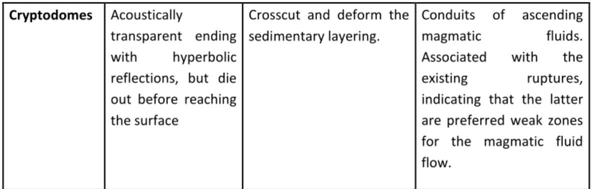
The tilted block is also notable for the difference in slip rates of the two active normal faults that form it. Finally, on the east side of the outer flanks of Columbus, we appear to have a rising flow of magmatic fluid that does not reach the surface.
Seismic profiles that crosscut the external flanks of Kolumbo submarine volcano The seismic profile 5-6-7 runs NE-SW, starts from 6km west of Anydhros island to the NE and
In the NE part of the profile, apparent layer C is associated with an eruptive event before 1650. Starting from the SW, the former deforms the lower part of the marine sediment sequence. It lies in the NE part of the basin and is about 12 km long.
At the NW part of the section, its continuity has been disrupted by two opposing normal faults. At the NE edge of the profile, a pair of normal faults border the basin area.
Seismic profiles parallel to the long axis of Anhydros basin
It starts from the eastern submarine slopes of Santorini to the SW and reaches the southern edge of the Anhydros reef. At the southwestern part of the profile we can clearly distinguish the listric level, previously mentioned in other sections, whose continuity seems to be interrupted by normal faults. It corresponds to the sedimentary sequence of the basin and to the NE appears to have been deformed by synsedimentary normal faults.
Tectonic Analysis
Further south, another normal fault (N45OE) forms the southern boundary of the basin. North of the Kolumbo Volcanic Chain, their orientation follows the direction of the basin, while east of Kolumbo the direction changes to NNE-SSW. The older ones are synsedimentary and have deformed the Plio-Quaternary marine fill of the basin.
Inactive normal faults, younger than the previous ones, are observed north of Columbus in the basin orientation. There are also two active faults in the basin, one north of the volcanic chain and one just east of Columbus, oriented NE-SW and NW-SW, respectively.
Paleogeographic Synthesis
Black outlines indicate how deep beneath the sea floor lie the base of the volcanic sequences. The correlation of all seismic profiles around the Columbo volcano resulted in a thickness map (Fig. 109) showing the distribution of the pyroclastic deposits from the 1650 AD eruption. The maximum thickness of these deposits is about 180 meters in the western part of the crater and covers an area of about 97.4 km2.
This map allows us to better understand the paleogeographic configuration of the basin, prior to the deposition of the volcanic sequences. Map showing the distribution of pyroclastic deposits from the AD 1650 eruption in the Anydhros basin.
Tsunami generation mechanisms
It is difficult to predict the exact nature of a future eruption of the Columbo volcano given that a detailed history of the volcano has yet to be determined. ROV explorations of the crater indicate that dacite and rhyolite are the most common volcanic products with little evidence of more mafic compositions. There is still no evidence of extensive dome-building episodes in the evolution of the volcano.
This is in contrast to recent studies (Dominey-Howes et al., 2000) which suggest that the size of the 1650 AD tsunami has probably been overestimated, as palaeontological and lithological studies along the east coast of Thera have shown no bio- or lithostratigraphic evidence for the deposition of marine (tsunami) deposited sediments. In light of the recognition of the potential tsunami-generating mechanisms at Columbo Volcano, a useful next step would be to perform computer simulations of possible tsunami magnitudes using geologically constrained parameters determined from new knowledge of the extent of the AD 1650 eruption.
Conclusions
According to historical reports, it was possible to determine that the tsunamis of 1650 AD had a maximum intensity of VI degrees in the six degree modified Ambraseys–Sieberg tsunami intensity scale (Ambraseys, 1962; Papadopoulos and Chalkis, 1984). The hydrothermal vent field in the crater floor of Kolumbo consists mainly of active and inactive sulfide-sulfate structures in the form of vertical towers and pinnacles, hills and flanges along a NE-SW trend, with temperatures up to 220 C and strong CO2 gas emission. For several years, the highest frequency of earthquakes was mainly concentrated in the vicinity of Columbo volcano.
Several earthquakes have recently occurred in the region south of Christianna on the SW edge of the CSK line. It is also consistent with the overall configuration of the Santorini volcanic field, which includes Christiana, as the distribution of all volcanic features of the area has a NE-SW orientation (Fig. 110).
Acknowledgments
The analysis and correlation of both bathymetric data and seismic profiles showed that Anhydros basin is a NE-SW oriented tectonic graben formed by normal marginal faults during Pliocene. Secondary tectonic features of normal or strike-slip character, active or inactive have been observed within the basinal area. KVC is under tectonic control and is aligned with Columbus fault line onshore at the NE part of Santorini, the hydrothermal field at the NE part of Santorini caldera and the dikes found at the northern Santorini caldera walls and the southern tip of Therasia. We therefore suggest that KVC is part of a wider NE-SW volcanotectonic zone developed within a tectonic graben bounded by Ios fault zone to the north and Anafi fault zone to the southeast.
What was revealed through the seismic profiles was the listric plane on the submarine slopes northeast of Santorini. Further seismic studies should be carried out in the area to better understand how this structure could be responsible for any differentiation between Santorini and the KVC and to have a clearer picture of the spatial distribution.
P and S velocity structures of the Santorini-Kolumbo volcanic system (Aegean Sea, Greece) obtained by nonlinear traveltime inversion and its tectonic implications. A west-east traverse along the magmatism of the southern Aegean volcanic arc in the light of volcanological, chemical and isotopic data. Santorini and Nisyros: Similarities and differences between two calderas of the modern Aegean Volcanic Arc.
Morphological Analysis and Related Volcanic Features of the Kolumbo Submarine Volcanic Chain (NE of Santorini Island, Aegean Volcanic Arc). Tectonic structure and volcanic centers on the eastern margin of the Aegean volcanic arc around Nisyros Island.