Favorable conservation status (FCS) is a general goal to be achieved for all habitat types and species of community interest and is defined in Article 1 of Habitats. 34;Conservation status' is defined in Article 1(e) and 1(i) of the Habitats Directive as a term describing the general status of a habitat type or species in a biogeographical region.
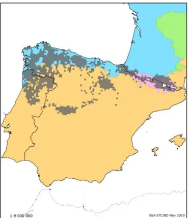
When a habitat type or species is almost entirely in one region, but the distribution is spreading across regional boundaries into a neighboring region in the same country (marginal occurrence), a single report may be submitted. For example, in France, the aquatic mammal Galemys pyrenaicus is mostly in the Alpine region, but its distribution is extended to adjacent parts of the Atlantic region (see Figure 1), so a single report covering both regions would be acceptable.
A report must still be submitted for these species, although in many cases it will only contain the species name and code, together with the name of the region and Member State.
III ASSESSING CONSERVATION STATUS
Many species, including some listed on the Annexes of the Habitats Directive (eg the Marsh fritillary Euphydryas aurinia) are known to have a metapopulation structure with cycles. Funits like that used for 'population' (see IV.b.iii). 1994) The UK status and putative metapopulation structure of a threatened European butterfly, the Marsh Fritillary, Eurodryas aurinia.

Favourable Reference Values for Canis lupus in the Continental region of - Historic distribution and abundances
- a.iv Using operators
- a.v Possible conflict between habitat types
- b TRENDS
- b.i Short & long term trends
- c MAIN PRESSURES AND THREATS
- c.i Time span for Art 17 reporting for threats and pressures
- c.ii Relative importance of threats and pressures
- c.iii Pollution qualifier (optional)
This revised list will also be used for the SDFs and for reporting under Article 12 of the Birds Directive. For the purposes of Art 17 reporting, at least the 2nd hierarchical level of the list should be used, e.g.
IV ASSESSING INDIVIDUAL PARAMETERS
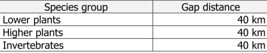
The range should represent a suitable parameter for assessing spatial aspects of conservation status. A standardized process is needed to ensure repeatability of range calculation across different reporting rounds.
The range must be calculated from the map of the actual distribution using a standardized algorithm. Whereas if the distance of 20 km was used, the drop in range would be about 3.
The range calculated by automatic gap filling should be adjusted to national boundaries, ecological and biogeographical constraints. A separate set of technical guidelines regarding the reach tool will be developed in the near future.
All cells that intersect this polyline and polygons, as well as all distribution cells, are used to create the range.
Range maps are generated for the entire Member State, but range parameters are reported separately for each biogeographical region. The range in the biogeographic region is represented by all networks that occur or partially occur within the region.
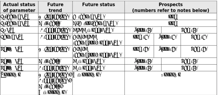
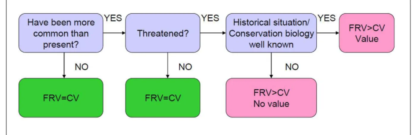
It is recommended to evaluate the future prospects by taking into account the future trends and the likely future status of the three other parameters, using the methodology described below and illustrated in Figure 6. The favorable reference values (FRV) in the other parameters can be used as thresholds. for assessing the long-term viability of the habitat or species.
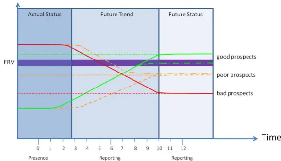
Clearly, once a parameter is identified as having a poor outlook, the future outlook assessment will be 'unfavorable-poor' and there is no need to review other parameters, but completing the process can help inform future management needs. Actual Status: Below FRV Future Trend: Declining Future Status: Below FRV Future Prospects: Poor Structure and Function Actual Status: Unknown Future Trend: Declining Future Status: Unknown Future Prospects: Unknown.
Information may also be available from the Global Biodiversity Information Facility (GBIF)39 while information on fish is given in Maitland (1994)40 and Fishbase41. For bryophytes some distribution data are available from the European Committee for the Conservation of Bryophytes42 while EMODnet Biology43 has information on marine species.
For reporting in terms of section 17, in cases of conflicting advice, the guidance given in these guidelines takes priority. Some of these are now old and in some cases only indicative while the Atlas Flora Europaea is incomplete; everything should be used with caution.
Please note that this example is not completely complete as all data is not yet available, but it is intended to show how cross-border assessment can be done.
From most of them there is information from the last 10 years A few sites were monitored at irregular intervals. At only two of those sites have more than 100 individuals been counted during the past 50 years.
In rare cases, a habitat may be an Annex I habitat type or a group of Annex I habitat types, and the information collected for habitat assessment may provide a habitat assessment for the species. By developing and implementing monitoring programs, it will be possible to clearly distinguish between the habitat actually occupied by the species and the potential (i.e. suitable) habitat.
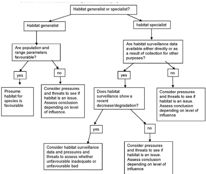
2 – There was only one species (Lucanus cervus) for which the results of a research program involving extensive habitat requirement studies could be adopted. If no map of the habitat range exists, it may be possible to model the range from other data sources, such as maps of potential natural vegetation (e.g. Bohn et al, 2004)56, distribution of key species, soil and geological maps, climate data or topographical maps.
As long as these processes are balanced in the long term for each characteristic species, the structure and function of the habitat type should be considered favorable. They must be sensitive to changes in habitat conditions (an 'early warning indicator species').

V MARINE HABITAT TYPES & SPECIES
Note that both the OSPAR and HELCOM conventions cover the Kattegat, while OSPAR and the Barcelona Convention both cover an area west of the Strait of Gibraltar. A digital version of the map of the marine areas can be downloaded from the Article 17 reference portal64.
In most cases, very little information is available for these species about the marine part of their life cycle. Please note that this list includes several Appendix I habitat types and Appendix II species that were not discussed at the Marine Natura 2000 seminars held in 2009 and 2010; This is because the marine seminars were held to discuss the species and habitats covered under a.
VI THE REPORTING FORMAT FOR 2007-2012
The first part of the reporting format, the general report, is primarily intended. In addition, this report briefly describes the main achievements in the implementation of the Habitats Directive and the main measures taken to ensure the network's compliance.
0 Member State
The reporting format tries to minimize the difficulties of using different languages by looking for numerical information everywhere. If you include web addresses in reporting fields, please provide them in full including the initial http:// if applicable.
1 Main achievements under the Habitats Directive
The text should be a maximum of 2 pages (Reportnet limits the length of the text . automatically). 2 General sources of information on the implementation of the Habitats Directive - links to Member States' sources of information.
2 General information sources on the implementation of the Habitats Directive – links to information sources of the Member States
If a Member State wishes to add further documentation to that required in this format, please note these annexes and their file names at the end of this free text section and upload the relevant files to Reportnet along with the other part of the report.
3 Natura 2000 – site designation
City B's maritime area should be entered in box 3.1.2 and its land area in box 3.1.1.
4 Comprehensive Management plans for the Natura 2000 sites (Art. 6(1))
In addition, an optional field (5.1.6) is available for information on the impact of projects requiring compensation measures on conservation status. Management of NATURA 2000 sites - The provisions of Article 6 of the 'Habitat' Directive 92/43/EEC' published by DG Environment in 12 EU languages).
6 Measures taken to ensure coherence of the Network (Art. 10)
This section reports on the number of projects/plans for which compensatory measures were necessary.
7 Reintroduction of Annex IV species (Art 22.a)
- Member State
- Species
- NATIONAL LEVEL
- Maps – distribution and range .1 Distribution map
Use codes (four character sequential code) and names provided in the Art 17 reporting checklist. In this case, all relevant data fields in the national report should be consistent, meaning that data field 2.3.1 (surface area of reach) will be based on the real distribution/area of the additional distribution map.
2 BIOGEOGRAPHICAL OR MARINE REGIONAL LEVEL
Biogeographical region or marine region
Since a generally accepted methodology (distances, fit, no manual intervention) was not fully accepted by Member States, range maps should be submitted as in the previous reporting round, using the same standard as for the distribution map in area 1.1 .1. or 1.1.4 and following the methodology described in section IV. Showing maritime regions is for practical/technical reasons; there are no other implications.
Published sources
Range
- Surface area - range
- Method used - surface area of range Use one of the following categories
- Short-term trend period
- Short term trend direction
- Short-term trend magnitude - optional
- Long-term trend – optional
- Favourable reference range
- Reason for change
It is recommended that the long-term trend be evaluated over a period of 24 years (4 reporting cycles). See guidance for filling in the fields 'long-term trend direction' (2.3.7) and 'long-term trend magnitude' (2.3.8) under short-term trend.
Population
- Population size estimation – using individuals/agreed exceptions
- Population size estimation – using other units
- Additional information on population estimates/conversion
- Year or period of estimation
- Method used – population size Use one of the following categories
- Short-term trend period
- Short-term trend direction
- Short-term trend magnitude - optional
- Method used – short-term trend for population Use one of the following categories
- Long-term trend period - optional
- Favourable reference population (FRP)
- Reason for change
It is recommended to evaluate the long-term trend over a period of 24 years (4 reporting cycles). Period, 'long-term trend direction' and 'magnitude of long-term trend' should be reported as for short-term trends.
Habitat for the species .1 Area estimation
- Year or period of estimation
- Method used – habitat for the species Use one of the following categories
- Quality of the habitat
- Short-term trend period
- Short-term trend direction
- Long-term trend period - optional
- Area of suitable habitat for the species
- Reason for change – short-term trend
The favorable reference population is the population required for the species to be in favorable conservation status. The assessment matrix requires a judgment as to whether this area is large enough and of suitable quality for the long-term survival of the species, but does not require a favorable reference value.
Main pressures
- Method used – pressures
The following questions are asked to avoid misinterpretation and to avoid misinterpretation of any changes between reporting rounds.
Main threats
- Method used – threats
If a Member State wishes to explain further, this can be done in field 2.8.2 Other relevant information. Please use the codes in the threat and pressure list for at least level 2.
Complementary information
- Justification of % thresholds for trends
- Other relevant information
- Transboundary assessment
Where a Member State wishes to provide more precise information on the nature of a particular threat, this may be entered in field 2.8.2 Other relevant information.
Conclusions
- Future prospects
Population
- Population size of the Annex II species in the Natura 2000 network - Estimation of population size covered by the network in the biogeographical region
- Method used: use one of the following categories
- Trend within the Natura 2000 network (optional)
Conservation measures taken by the Member State
- Measure List up to 20 measures taken during the the reporting period (i.e
- Type Tick the relevant type or types of the conservation measure
- Ranking Select and highlight (use an 'H') up to five measures that are considered the most important. The importance of the measure should be assessed in terms of the
- Location
- Broad evaluation of the measure
- Habitat Code
- Maps – distribution and range
- Distribution map
- Method used – distribution map
- Additional distribution map - optional
- Range map
- Biogeographical region or marine region concerned within the MS
- Method used - Surface area of range Use one of the following categories
- Short-term trend direction
- Long-term trend - optional
- Area covered by habitat
- Surface area - distribution
- Year or period of estimation
- Method used
- Short-term trend period
- Short-term trend direction
- Short-term trend magnitude - optional
- Method used – short-term trend Use one of the following categories
- Long-term trend - optional
- Favourable reference area
- Reason for change
- Main pressures
- Method used - pressures
- Threats
- Method used – threats
- Complementary information
- Justification of % thresholds for trends
- Structure and functions – method used
- Other relevant information
- Conclusions
- Future prospects
- Area covered by the habitat type
- Surface area of the Annex I habitat type in the Natura 2000 network
- Trend within the Natura 2000 network - optional
- Ranking Select and highlight (use an 'H') up to five measures that are considered the most important; the importance of the measure should be assessed in terms of the
This section includes the assessment of conservation status at the end of the reporting period in the relevant biogeographic region or marine region. Estimation of the habitat type area covered by the network in the relevant biogeographical region.

QUICK REMINDERS
Background information on invertebrates in the Habitats Directive and the Bern Convention - Part II – Mantodea, Odonata, Orthoptera & Arachnida. Background information on invertebrates in the Habitats Directive and the Bern Convention - Part III - Mollusca &.
APPENDICES
DOCUMENTS AVAILABLE ON THE ARTICLE 17 REFERENCE PORTAL Documentation
LYCOPODIUM SPECIES IN EUROPE
EXAMPLES OF REPORTING THREATS & PRESSURES
- Threats
Desalination of large brackish marshes in peatlands as a result of inpoldering (historically: J02.01.02, but the impact process is still ongoing: . K01). Reduction of quality (composition of species, B01.01 Planting of forests associated with hydrological damage and loss of biological crust of lichens and mosses, soil degradation) and/or extent due to planting of forests mainly with Pinus halepensis and Quercus ilex subsp.
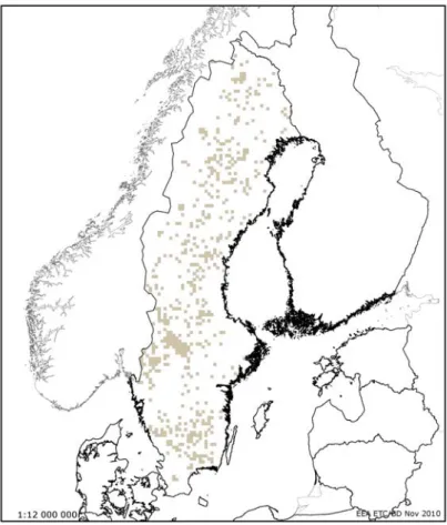
CONVERTING POPULATION DATA TO INDIVIDUALS The 3 examples described are all from the Boreal region of Sweden
STRUCTURE & FUNCTION AND SELECTING TYPICAL SPECIES a General guidelines
Effects of grazing and eutrophication can be seen through other parameters (e.g. species composition, dune dynamics). Effects of grazing and eutrophication can be seen through other parameters (e.g. species composition, dune dynamics).
TRANSBOUNDARY ASSESSMENTS - AN ANNOTATED EXAMPLE
- Alternative species scientific name
- Common name
- Short-term trend
- Short term trend
- Short-term trend magnitude
- Reason for change Is the difference between the
- Population size estimation
- Additional
- Short-term trend
- Favourable reference population
- Habitat for the species
- Year or period
- Short-term trend
- Short-term trend Trend direction
- Long-term trend
- Area of suitable habitat for the species
- Method used –
- Justification of %
- Other relevant information
- Trans-boundary
- Conclusions (assessment of conservation status at end of reporting period) Favourable (FV) [no evidence of a decline in range]
- Range
- Population
- Habitat for the species
Example of the Joint Cetacean Protocol output - distribution change of minke whale in the Irish Sea (Paxman & Thomas, 2010). It is considered likely that the population is stable in the long term (Reilly et al, 2010).