The positions of vessel A and vessel B are the positions of the GPS antenna mounted above the bridge. Officer B"), the helmsman of vessel B (hereafter "helmsman B"), the operational report of Kobe Port radio *3 (hereafter "port radio") and Company A's response to the questionnaire.
Injuries to Persons
Damage to Vessels
Crew Information
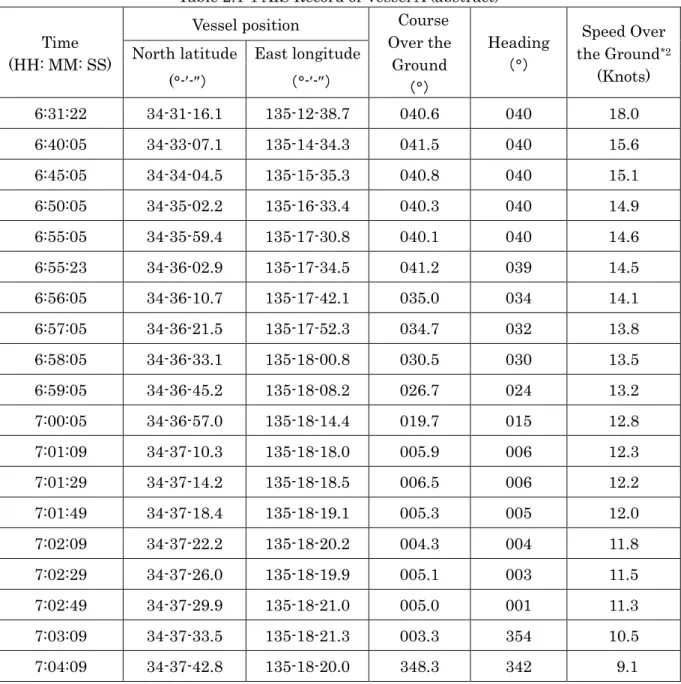
Since 2003, Master A has taken over the position of master, as the master of vessel A has been on board since March 2018, and has experienced entering the Kobe area of Hanshin Port eight times as master. Since 2002, Master B has assumed the position of master, as Master of Vessel B, he has been on board since November 2017, and has experienced a total of more than one hundred times entering the Kobe area of Hanshin Port as master.
Vessel Information
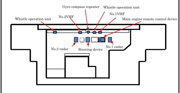
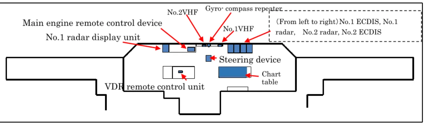
2 ECDIS on the starboard side of the bow window side, main engine remote control device and no. According to the statements of Commander B, at the time of the accident, Commander B was setting range no.
Weather and Sea Conditions
According to the statement of master B and the response of company A to the questionnaire at the time of the accident, there were no defects or damage to the hulls, engines and equipment of vessels A and vessels B.
Characteristics of the Area
According to Captain B's statement and company A's questionnaire reply, there were no malfunctions or defects in the hulls, engines and equipment of ship A and ship B at the time of the accident. 2) According to the "Sailing Directions for Seto Naikai issued by the Japanese Coast Guard, car ferries arriving and departing from the ferry pier in the northeastern part of Rokko Island travel in and out along the East Waterway. Entry Manual,” and requested the shipping agencies to distribute and equip it to the ships entering and leaving the Kobe area of Hanshin Port.
Information on the Safety Management of Vessel A
Although the "Port Entry Manual" was not based on laws and regulations, it was an administrative guideline and the municipal government tried to make people aware of the items written based on the agreement of maritime officials in Kobe Area , Hanshin Port. Pursuant to Article 35 of the Pilotage Act and Article 5 of the Law Enforcement Ordinance, the Osaka Bay area, which was the site of this accident, has been designated as a mandatory pilotage area, and the master who operates a vessel with a gross tonnage of 10,000 tons or more must have a pilot on board.
Information on BRM Training
Analysis Survey on Accident Occurrence Factors
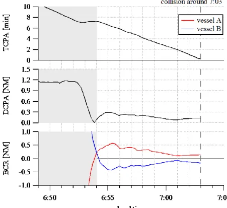
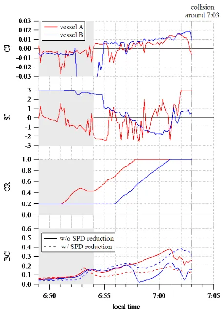
Also at the time of the accident, the situation was just before arrival at the port, and because the engine could be braked, it is assumed that the way to yield is both a change of course and a delay. port side of vessel B except at the time immediately before the collision, and was out of the course that vessel B was proceeding. ii) Evaluation of dangerous condition between two vessels a. The increase in the BC value means that the freedom of maneuver decreases, and the possible range of the BC value is between 0 and 1. The BC values evaluated for Central Buoy and vessels around Vessel A and Vessel B at 06: 55 rose. for both vessels.
ANALYSIS
Situation of the Accident Occurrence
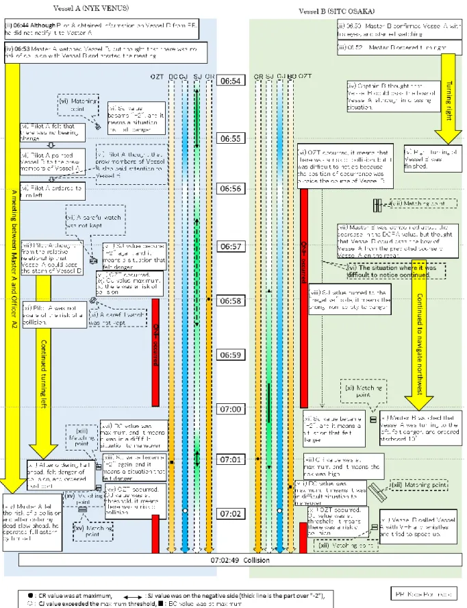
Describe the whole matter and find the cause. ii) Actions to focus on (dangerous actions) and underlying factors of Vessels A and Vessel B were as follows. It is very likely that vessel B started to turn right about 2.2m south-east of the center buoy at about 06:52:23. you).
Causal Factors of the Accident
It is likely that Master B was concerned about the drop in the DCPA value around 06:57, but from the ship's predicted course. It is likely that vessel B was in a difficult maneuvering situation as the BC value reached its maximum value around 07:01. It is likely that the SJ value read “-2” around 07:01, which was consistent with Master B sensing a collision risk.
Analysis on Loss of VDR Data of Vessel A
A used VHF until immediately before the collision, believing that vessel B might pass the bow side of the vessel. It is likely that since VHF was not used to communicate with each other from earlier stages, when vessel A and vessel B could get close to each other at short range, they could not confirm another vessel's maneuvering intention, therefore it became a situation where two vessels approached each other too closely.
CONCLUSIONS
Probable Causes
Other Discovered Safety-Related Matters
SAFETY ACTIONS
Safety Actions Taken
He stated that insufficient navigation and maneuvering, pilot dependence, lack of situational judgment and failure of the BTM*19 were the causes of the accident. Also, Company A sent a document, which sought to re-acknowledge the importance of safe navigation, to the masters and officers of Company A's ships, including Ship A. Company B listed the causes of the accident as: Ship A failed to keep a lookout correctly, both vessels did not slow down until before the accident and they could not cooperate to avoid the accident because vessel A was not maneuvering properly.
Safety Actions Required
In addition, Company A reviewed its briefing checklist, reviewed BRM/BTM training, and conducted VDR operational training. Based on the lessons learned from the accident, Company B instituted a safety action month for all company ships to check safety awareness, viewing conditions, compliance with company rules, in addition to revising a pre-boarding training for captains and officers.
Process and Progress of the Accident Table
Although concerned about the drop in DCPA value, Master B believed that Vessel B was able to pass the bow of Vessel A without difficulty from Vessel A's predicted course by the radar. Ordered officer A1 to make the main engine half-forward as vessel A approached Eastern Waterway. Master A heard the instructions from Pilot A and looked to the bow and sensed the danger of a collision.
REPORT
Purpose of the Investigation
The purpose of this investigation was to contribute to the investigation of the collision accident between the container ship NYK VENUS (hereinafter referred to as "Vessel A") and the container ship SITC OSAKA (hereinafter referred to as "Vessel B"), which occurred near a point located 350 m southwest of the center floating lighted buoy of the east fairway of Kobe Rokko Island in the Kobe area of Hanshin Port on May 4, 2018 at around 07:02:49. For this purpose, situational awareness is required in relation to the behavioral status of the two vessels that caused the collision were evaluated based on AIS data, the navigational status was analyzed based on historical records of large vessels entering the port, the factors that caused accident, were analyzed using CREAM (method of cognitive reliability and error analysis).
Outline of the Investigation
Cognitive factor analysis was conducted using the CREAM method, based primarily on interview research with ship handlers and others provided by the Japan Transportation Safety Board.
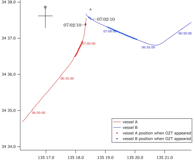
Navigational Tracks Around the Time of the Accident
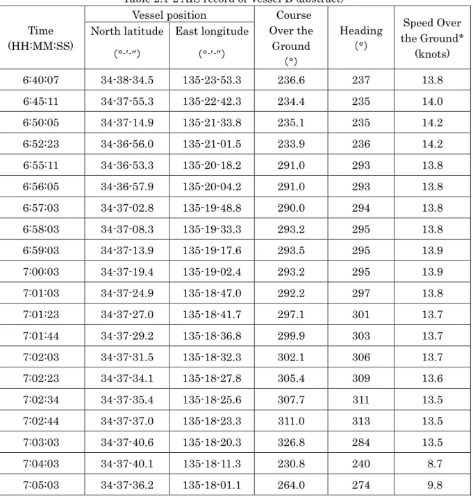
Time-related Changes in the Quantitative Status of Vessel A and Vessel B
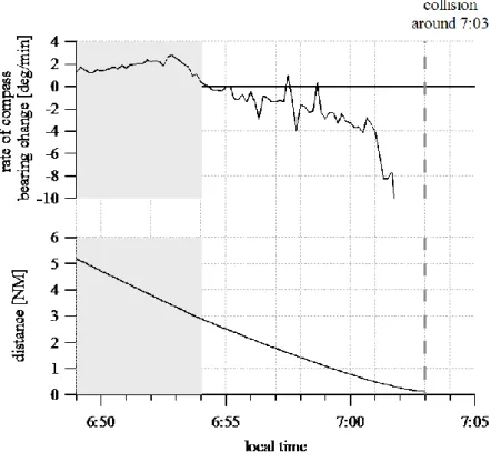
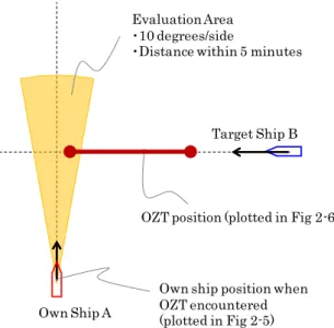
Location of OZT Occurrence
2-6 gives the position of the OZT encountered by both ships together with a track chart. When she first encountered the OZT, her speed was approximately 13.6 kt and the distance from ship A to the OZT was approximately 1.1 NM. When she first encountered OZT, her speed was approximately 13.9 kt and the distance from ship B to OZT was approximately 1.1 NM.
Time-related Changes in Collision Risk Level
Vessel A's SJ moves to the negative side, indicating danger, before 06:54, when Vessel B completed the change of course. Whether the means of departure is course change only or course change and speed reduction, ship A's BC increases as a whole from about 06:55 and ship B's BC increases from 06:55, although it decreases temporarily at about 06 : 58. 2-1 when ship A's means of departure are both course change and speed reduction and ship B's means of departure are course change only.
CPA Analysis Taking Account of Vessel Length
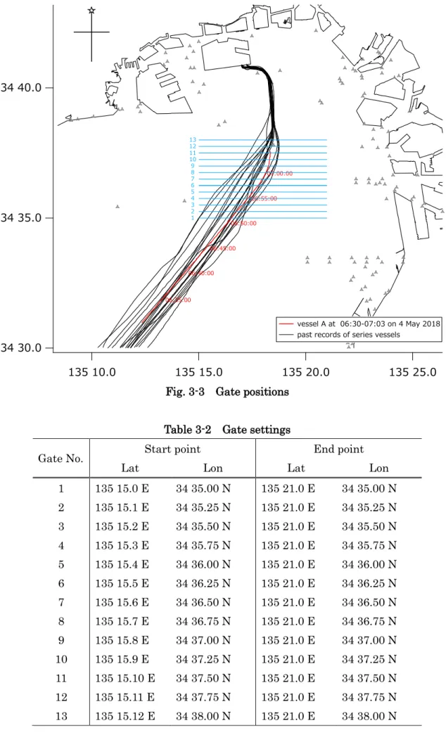
The numerical values in parentheses indicate the reference point for calculating this time. 3 Navigational status based on past records of large vessels entering the port 3.1 Records of entering the port.
![Table 2-2 Collision points taken as datum points Distance from antenna position [m]](https://thumb-eu.123doks.com/thumbv2/9pdfnet/19347721.0/60.892.182.736.119.675/table-collision-points-taken-points-distance-antenna-position.webp)
Navigational Track When Entering Port
At the time of the accident, numerous anchored vessels were present in the vicinity of the waterway. 3-1 superimposed with vessel B's navigation track and the positions of vessels anchored at the time of the accident (including some vessels that were not fully anchored around 06:55). Additionally, according to the literature, separation distance from anchored vessels and buoys is expressed with the following equation.10) Here, the positions and separation distances of anchored vessels and light buoys that may become obstacles for the paths of both vessels in the sea area around the accident are shown in Fig. In consideration of vessel A's method of entering port at the time of the accident, because the sea area on the port side of Kobe Rokko Island East Waterway's middle floating lighted buoy.

Speed when Entering Port
In addition, DCPA observed on vessel B was close to the numerical value when the antenna position was used as the datum, and was evaluated to exceed a maximum of about 210 m as the actual clearance when the length of vessel A and vessel B was. It can be said that many vessels were navigating on the starboard side of Kobe Rokko Island East Waterway's middle floating lighted buoy when they started the route taken by vessel A at 06:55 at the time of the accident. The speed at which vessel A was navigating at the time of the accident was a standard speed compared to the speed of vessels entering port in the past, although slightly faster than average.
The CREAM Analysis Method
It has been confirmed that there are discrepancies with previous records in the navigation track when entering the port. Conclusions about the cause of the accident subject to analysis are reached by combining the result of CPC evaluation with background factor analysis based on failure modes.
Accident Progression
- Outline
Center Buoy: Kobe Rokko Island East Waterway's center buoy, with floating light, communicates with Kobe Port Radio. Finished leaving port and went to bridge Contacted Kobe Port Radio to inform about scheduled 07:15 port entry; taken. Was anxious about lowering the CPA, but felt that increasing speed here to pass A-ship's bow would result in too much speed when entering port.

CPC Evaluation
- Result of CPC Evaluation of Vessel A
- Result of CPC Evaluation of Vessel B
But the pilot later thought the master was on watch and the master and C/O were talking before port call and not on watch. There was no communication by radio, whistle, etc. with vessel B. The master, C/O and others did not receive information about vessel B from the pilot. Two radars were installed, the master and C/O used them, and the equipment was effectively laid out.

Analysis of Background Factors
- Pilot of Vessel A
- Master of Vessel A
- Master of Vessel B
However, the master of vessel A judged that vessel B was on the opposite course before changing course and discussing entering port with the master while facing astern. Estimated prior to vessel B's turn that vessel B was on the opposite course and would move away and did not continue the watch. Based on the predicted radar heading, the master of vessel B thought that vessel A would pass the east side of the center buoy.

Discussion
- Vessel A
- Vessel B
He felt the danger of collision, as he could not make a great turn to starboard owing to the presence of the ships at anchor; however, he did not confirm Vessel A's intentions by VHF or give an alarm using the whistle or other means until shortly before the collision. Before vessel B changed course, it was judged that vessel B was heading in the opposite direction and thus there was no risk of collision. The master was not sure of A's maneuvering because he thought A would be sailing on the east side of the center buoy.
Summary
At this time, CE and CF become the own ship's course, so that DCPA = r, and ΔC, which is between these two courses, becomes the area of the collision course. Finally, as shown in the equation (Attachment 6), the subjective crash risk level is obtained from the weighting factor ω𝑖,𝑗 and the weighted average of the nine rules SJij. The TCPA and DCPA of both vessels are corrected by the equation (attached material 7) taking into account the maneuverability and length of the own ship.