The main objectives of master's thesis are mapping of lakes and watercourses in the Lena delta and adjacent Bykovsky Peninsula with subsequent determination of the height of the water's edge of these objects. Statistical and visual analysis based on the obtained map of lakes, watercourses of the Lena delta with an area of more than 100 m² and Bykovsky peninsula and the height of the water's edge of these objects makes it possible to distinguish terraces according to limnicity and reflect differences in level and elevation characteristics of lakes in different terraces.
Introduction
Objectives
The main objective of this work is to map the spatial extent of water bodies in the Lena Delta region in high resolution and to determine their water level height using remote sensing data and GIS methods. The water level elevation of thermokarst lakes in the Lena Delta is an important indicator to assess the extent of permafrost degradation that this landscape has experienced in the past, as well as to analyze the vulnerability of this region to future flooding against the background of current sea level rise, which has been observed to be about 1.84 mm per year in the Laptev Sea (Proshutinskiy et al., 2004).
Study area
According to Grosse et al., (2007), the peninsula is an erosional remnant of a Late Pleistocene accumulation plain consisting predominantly of silty to sandy ice-rich permafrost deposits of the yedoma. 12 The climate of the Bykovsky Peninsula is similar to the Lena Delta due to their close location.
Geomorphological and Geological settings
An active role in the formation and evolution of the Lena Delta is played by tectonism during the Pleistocene and also the Holocene. Thus, the delta was formed as a result of vertical tectonic movements, continuous sedimentation of Upper Pleistocene depositional units, the development of Holocene reliefs and modern hydrological processes of the Lena River.
Materials and Methods
Data
- Satellite images
- Digital Elevation Model
- Additional GIS layers
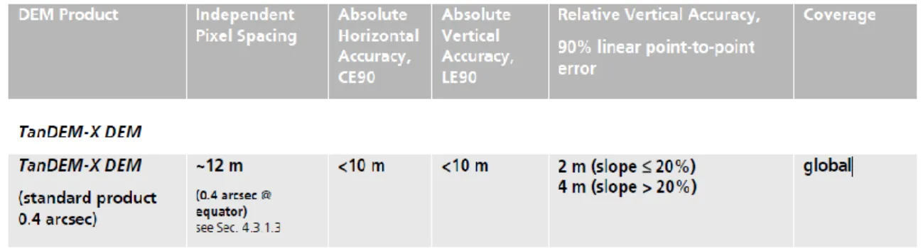
The height values of the initial DEM sub-tiles represent the ellipsoidal heights relative to the WGS84 ellipsoid at the WGS84-G1150 datum. Point measurements of ground surface elevation within the 35 m radius tracks were spaced 175 m along the track and 16 – 25 km along the track in the Lena Delta (fig. 2.2).
Methods
- Satellite images sets processing
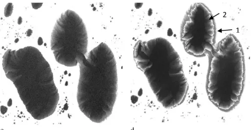
- Creation of water mask
- DEM refinement
- Computation of characteristics
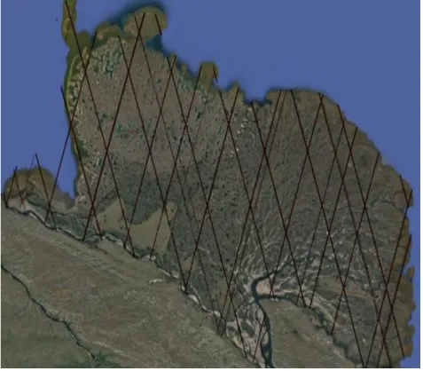
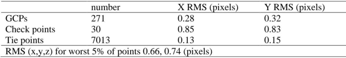
To perform the calculation of the mathematical model and the orthorectification, the Geomatica OrthoEngine module was used (fig. 2.4). Solving the mathematical model calculates the position and orientation of the sensor - aerial camera or satellite - at the time when. The residual error is the difference between the real coordinates of ground control points or tie points and where those points are according to the calculated mathematical model (PCI, 2015).
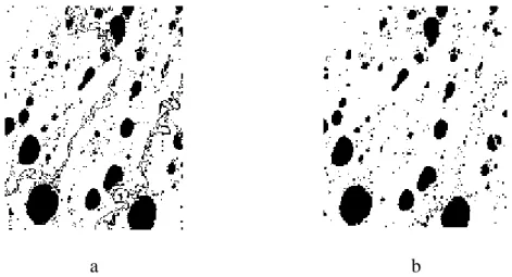
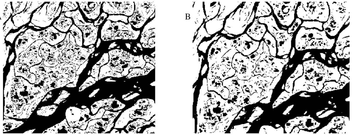
As a result, two different layers were obtained, showing the water bodies of the Lena delta (Fig. 2.5 b, c). Therefore, a highly detailed vector mask of water bodies was used to edit the lake surface elevations in the DEM. Analyzes of the results are based on a GIS layer (ESRI shape file), which contains the shapes of all water bodies.
A total area of the watercourses in the delta mapped in this study is approximately 4237 km².
Spatial statistics
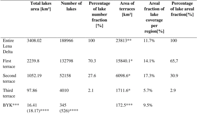
Although 70% of the total amount of lakes is concentrated on this terrace, their surface area is somewhat lower at about two-thirds of the total lake surface in the Lena delta (fig. The third terrace is characterized by the largest (24.4 ha) and the first terrace according to the smallest average size of the lakes (16.9 ha) The general distribution of the surface of the lakes in the entire Lena delta is shown in Fig. 3.4 The grouping by area for analysis is based on Bolshiyanov et al.
With this, only a small part of the lakes can be considered large with an area of more than 1 km². For the second group, the number of lakes correlates well with a territory occupied by this group. For example, the number of lakes in the third group is about four times more than in the fourth group, but the values of archived areas are very similar.
The area of distribution covered by lakes in relation to terraces is considered (Fig. 3.5) in accordance with the grouping of lake areas based on the work of Boika et al. 2013), where the lakes are divided into three groups based on their surface area: polygonal lakes, polygonal lakes, and thermokarst lakes.
Lake height distribution
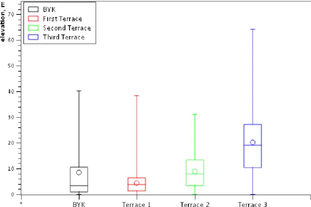
The results of statistical analysis (mean, median and STD values) of lakes' elevation generally reflect all terrace levels of the Lena Delta. Based on figure 3.8, it is clear that the distribution interval of lakes' height values is the largest for the third terrace and the maximum height of lakes' water level is above 64 m. This is of particular importance as the Bykovsky Peninsula geomorphologically belongs to the third terrace (Grigoriev, 1993).
Most often, lakes are located in the Lena Delta and on the Bykovsky Peninsula at heights between 2 and 10 m (Fig. 3.9 a, b). Elevation method for the entire Lena Delta and Bykovsky Peninsula is 0 m. The exception is the third terrace, where the height is more than 18 m. The pattern of lake area in relation to height (Fig.3.9b) generally matches the number of lakes in relation to height (fig. 3.9a).
The approximate average height of the lakes does not depend on the size of the lakes, the average height for all groups is approximately the same and amounts to approximately 8.5 m (tab. 3.3).
Vertical section of the Lena Delta based on the lakes level heights
Statistical features, showing the relationship between lake height and lake size, were evaluated on the example of Bykovsky Peninsula (fig. 3.10). In order to display the variability of the Lena Delta topography in relation to its geomorphological structure, a section presented in figure 3.11, crossing all terraces in the Lena Delta in the direction from North-West to South-East and. 44 separately, each terrace from West to East shows considerable scattering of lake views over the entire area.
On the other hand, each terrace can be distinguished based on this map. On this graph, the island of Arga in the northwestern part of the delta, which builds the second terrace, is particularly prominent. The island of Sobo-Sise (third terrace) in the eastern part of the delta is also clearly visible on the profile.
The areas in between show fairly well the general height decrease from lake water in the central part of the first terrace to the sea coast line on the eastern edge of the delta.
Discussion
Applicability of remote sensing data processing and GIS methods for creation of
As in the study by Schneider et al., (2009), this study did not properly consider seasonal variation of the water level, which is maximum in May – June and minimum in the winter months. Such a decision had a negative impact on the further morphometric calculations in the western part of the Lena River Delta. However, to distinguish between wetlands, Schneider et al., (2009) used supervised classification approach based on a small number of classes.
47 al., (2008) applied a simple density slice classification to distinguish water and land in the panchromatic images. Usually there is a strong difference in reflectance in near-infrared band between water bodies (low DN shows dark) and bare or vegetated land surface (high DN shows bright) (Grosse et al., 2008). More about Schneider et al., (2009) noted that vegetation either growing or floating in the lake can present a challenge to any water-land discrimination methods.
Morphological opening of an image is defined as the expansion of the erosion of the image.
Discussion of obtained results
Relatively large lakes, the average surface of which is greater than 20,000 m² are located mainly on the second terrace in the eastern part of the delta, probably due to the antiquity of this part (Bolshiyanov et al., 2013). The Lena river delta is generally flat, because the first terrace occupies the largest area and this is reflected in the average height of the lake level, which is only 5.9 m. The height of lakeshore levels in the central part is mostly between 6 and 8 m per year, compared to 0 - 2 m per year.
Such a disparity in the height of a terrace is caused by the significant difference in the age of the areas. The 2nd terrace is intermediate in the Lena River Delta by area and elevation, maximum surface elevations reaching 30 m above sea level. The limnity, especially of Island Arga, which is the largest part of the terrace, is highest (>17%) in the Lena River Delta.
Moderate permafrost changes in the Lena River delta during the last 30 years are associated with the subsidence of small thermokarst lakes on the third terrace (Kravtsova and Bystrova, 2009).
Conclusions
57 In addition, during the execution of this thesis, several field studies were carried out with the aim of determining the suitable methods for morphological filtering and DEM water mask refinement. As a result, 198851 water elements with a size of more than 100 m² were mapped for the first time in the region of the entire Lena delta and the adjacent Bykovsky Peninsula. Obtained spatial data and elevation data show fairly accurately the division of the delta into three main terraces.
The evaluation of the results shows a significant dispersion of lake characteristics and heights, as well as differences in limnicity between the main geomorphological terraces. The above-mentioned data are therefore in good agreement with previous studies related to the analysis of the spatial characteristics and distribution of lakes and the evaluation of the value of terrace heights. However, it is worth saying that the use of high-resolution data allowed us to make a new assessment of the number of small ponds and their influence on the statistical characteristics of water bodies in the region of interest, compared to previous studies.
It is planned in the near future to get the slopes of the water channels, because the main preparation steps have already been done, including the design of the river channels for the entire delta.
Acknowledgements
Short-term and long-term thermoerosion of ice-rich permafrost shores in the Laptev Sea region. Subpixel heterogeneity of an ice-wedge polygonal tundra: a multiscale analysis of land cover and evapotranspiration in the Lena River Delta, Siberia. Sensing landscape dynamics in the Arctic Lena Delta with temporally dense Landsat Remote Sens.
Coastal erosion versus river sediment discharge in the Arctic Shelf seas, International Journal of Earth Sciences, Springer-Verlag. Detecting landscape dynamics in the Arctic Lena Delta with temporally dense Landsat time series stacks. Spectral characterization of periglacial surfaces and geomorphological units in the Arctic Lena Delta using field spectrometry and remote sensing.
Formation of relief in the regions with distribution of ice complex deposits: remote sensing and GIS studies in the Kolyma lowland tundra.