Channelized materials (hmch) occur in the nW (arena colles region, hmchac) and s (libya Montes, hmchlM) parts of the Isidis basin. Conical plains (HAcp) occur in the lowlands and occupy the bottom of the Isidis basin.

115:E06006, DOI 10.1029/2009JE003458
Therefore, one of the first goals of a network mission is the seismic discovery of Mars. We present here the status of the development of a space-qualified Very Broad Band seismometer in Europe.

MARTIAN EXPLORATION
INSTRUMENTATION FOR MARS EXPLORATION
Such technologies are well known in the process of qualification and testing in the framework of various esa and Micinn technology programs, and can be considered critical to obtain better MVP and BP earnings figures in future exploration tools. The SMARQ material, and various actuators (pin puller, twist, hold and release actuators) are qualified for use in space in the framework of various contracts with the European Space Agency.
MINIATURE LASER -ABLATION MASS ANALYSER desiGned for sPace research
Part of the mass spectrum recorded in the studies of the SRM 661 standard for steel. Wurz, “A miniature mass analyzer for in situ elemental analysis of planetary material: performance studies,” Anal.

INTERFEROMETRY AND DOPPLER EXPERIMENT (PRIDE): APPLICATIONS FOR THE PHOBOS-SOIL
Methane may originate from geothermal or biological activity near the red planet's surface. In addition, the Raman technique is applied to samples of the methane-producing archaea candidateus Methanosarcina gelisolum (strain SMA 21) isolated from soils affected by Siberian permafrost.
MONTE-CARLO 3D SIMULATION OF PLANETARY sUrface iMaGinG throUGh the oPtically
Ekonomov, Space Research Institute (IKI), Russia, Contact
Because the escape velocity from Phobos varies by more than a factor of two over the surface of the satellite, it is possible that the ejecta clasts are again driven away from the surface after the generation of channels. Because of Phobos' local terrain irregularities and the moon's small body radius, nearly all of the parallel ejection lines would arrive at Phobos at oblique angles along the shock.

GROOVES OF PHOBOS AS SEEN ON THE MEX hrsc rectified iMaGes and coMParisons
Detailed studies of these elongated craters have been carried out for some of the inner planets. When evaluating the results of this study and other studies, it seems likely that at least some of the elongated craters on Mars were due to the impact of earlier satellites [5].

LANDING SITE REGION OF THE PHOBOS-GRUNT lander for different seasons: the Model
PHOBOS GEODESY EXPERIMENT USING
RADIO-TRACKING DATA OF THE PHOBOS-SOIL sPacecraft: constraints on the interior
Our proposed GIS mapping technology can be used for the cartographic support of the Russian project Phobos-Grunt. Introduction: The gas analytical experiment aims at the comprehensive investigation of the inventory of volatiles in the Phobos surface material. Principles of measuring volatile components: GaP receives a portion of the ground from the sample acquisition device of the manipulator.
The science payload of the Phobos-Grunt mission includes the Gas Analytical Package (GaP) dedicated to the chemical analysis of the collected samples.
![Fig. 1. control points (white circles) of the using network in comparison with the Willner control point network (black circles) [6]](https://thumb-eu.123doks.com/thumbv2/pdfplayernet/436471.50985/41.1318.1010.1245.45.204/control-circles-network-comparison-willner-control-network-circles.webp)
SPECTROMETER MIMOS II FOR THE PHOBOS- soil Mission
The chosen frequency range makes it possible to probe the Phobos ground on the accepted model to depths of units up to hundreds of meters with a resolution of approximately 2 meters. Survey sounding of the Phobos surface in SC in a quasi-synchronous orbit (a mode 1 (low informative) - 4 sessions for 3 hours), (Fig. 1). Detailed sounding of the chosen locations of a surface in SC in a quasisynchronous orbit (a mode 2 (very informative) - 6 sessions for 5 minutes), (Fig. 2).
The value of the carrier frequency (or center frequency of the signal spectrum) of the ground sounding radar is determined by the compromise between several mutually inconsistent requirements.
TIMM: ECHELLE-SPECTROMETER TO STUDY THE atMosPhere of Mars
GEOLOGY OF PHOBOS-GRUNT LANDING SITES: A VIEW FROM THE MEX HRSC IMAGES
Scientific interest in the mechanisms of cellular resistance, the duration of cell viability and the role of stress in the evolutionary process is growing. The low-cost biological experiment "BioPhobos" will make it possible to obtain extremely important information, in particular, to study the resistance and ability to survive a large number of terrestrial organisms in the deep space environment during the interplanetary transition (transpermia), to assess the effects of long-term exposure to cosmic factors on the interaction of microorganisms and the geological substrate, to investigate the transformation of native microbial communities, to analyze a soil sample from Phobos (presumably the matrix material of the solar system with the inclusion of Martian matter), including the search for biosignatures (panspermia, transpermia) and to determine the requirements for interplanetary transport of extraterrestrial samples.
THE CHOMIK INSTRUMENT FOR PHOBOS-GRUNT MISSION – FUNCTIONAL TEST AND CALIBRATION
RADIO SCIENCE EXPERIMENTS OF JOINT OBSERVATION OF YH-1 AND PHOBOS-GRUNT
Based on the above estimate, the mass of volatile compounds remaining in the lunar environment will be 3.4x10¹⁷g. Immature soil (marked in green, box 3) occupies most areas of the inner wall slopes of the crater. Extremely immature soil, coded in color field 4, reveals near part of the northern slope of the crater wall.
We are on the verge of a renaissance in our study and understanding of the Moon.
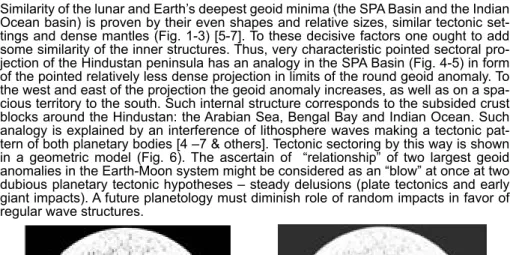
THE LUNAR SOUTH POLE-AITKEN BASIN AS A TECTONIC EQUIVALENT OF THE INDIAN GEOID
To the west and east of the projection the geoid anomaly increases, as does over a wide area to the south. Proceedings of the I-III scientific seminars TRINITI RAS-MSU Sectoral tectonics of the Earth's Eastern Hemisphere and its crucial role in the localization of gigantic ore deposits, prominent rift systems and major flood basalt provinces // Global Tectonics and Metallogeny, V. 1998). The Moon: Earth-type sectoral tectonics, relief and relevant chemical features // Abstracts of papers submitted to the 3rd International Conference on Exploration and Use of the Moon, October 2010).
Two deepest geoid minima on the Earth (Indian) and the Moon (South Pole-Aitken Basin) considered to have different origins, but surprisingly similar due to their tectonic positions //: "Planet Earth" system: 300th anniversary of M.V.
SHARING LUNAR EXPLORATION WITH THE WORLD: EXAMPLES FROM THE MOON
A second exposure of the new Mg-spinel rock type was discovered in connection with the Nektar basin on the near side [8]. The seismic detection of the two-layer lunar core was obtained after reanalysis of the Apollo lunar seismograms ([3]Weber et al., 2011). The expected amplitude of the free core libation lies in the range 1–3 milliarc-seconds.
They can play an important role in determining the parameters of the core: radius, density and geochemical composition.
SIGNIFICANT RESULTS FROM CHANDRAYAAN-1 Mission
REGIONS OF WATER-RICH PERMAFROST ON THE Moon: resUlts froM lend in lro
EPITHERMAL FLUX DEPRESSION AND PSR IN shoeMaKer crater
Thus, by raising the vertical column of the lunar soil up to 4 meters, we can obtain information about the changing content of external radiation in the history of the moon's development. Fig.2 typical shape of the impact melt on the necho crater (lroc camera), which is located on the far side of the Moon. Introduction: the dependence of the color ratio of the lunar surface on the phase angle α is poorly studied.
9] have shown that the phase curve of the Moon's color ratio in the range 359–1064 nm reveals a maximum at α near 50º and may possibly have a minimum near 10º.
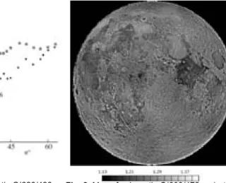
PHASE-RATIO AND COLOR-RATIO IMAGERY OF lUnar crater caUchy
The combination of phase-ratio and color-ratio images can be important for studying asteroids and moons of planets. Right: Distribution of phase ratio A(65º)/A(29º) for the same scene. 1993) Theory of reflectance and emittance spectroscopy.

RADAR COMPLEX IN THE PROJECT “MOON- GLOB”: MONO- AND BISTATIC- RADIO LOCATION
In this mode, at the 100-150 km altitudes the radar RLK-L receives the signal emitted by an Earth-based transmitter at one of the frequencies in the range of 17-23
The action of eruptive activity and optical-acoustic effects (γ- and X-ray pulse components of the flash) on the seismic fields of the Moon is investigated. Probably similar properties of the wave field of the Moon can show the dynamics of wave processes in the Sun. Deep fractures of the lunar lithosphere promote the formation of several waves from strong shock sources, such as PKiKP type, as well as RsR, etc.
We invert the apollo lunar seismic dataset together with geochemical models of the lunar thermal state.
![Fig. 1: Laboratory VNIR reflectance spectra. (L) Spectra from [15] of lunar samples used for ground truth and interpretation of remote reflectance spectra](https://thumb-eu.123doks.com/thumbv2/pdfplayernet/436471.50985/88.659.72.523.210.372/laboratory-reflectance-spectra-spectra-samples-interpretation-reflectance-spectra.webp)
SOURCE CUTOFF FREQUENCY ESTIMATIONS for a nUMBer of iMPacts detected By the
We compared these modern coordinates with the previously published and predicted coordinates in the USSR (20th century) system and studied relationships between the two sets. Our preliminary findings are that the planar coordinates (latitude and longitude) of the Ussr (20th century) system correspond to the coordinates in the ME system within errors in the range of о km at the equator). We conclude that discrepancies between the previously published and true coordinates of the Soviet landers are due to systematic lateral and rotational shifts of the coordinate systems used, lack of knowledge regarding absolute lunar altitudes, as well as random ballistic errors.
GIS-ANALYSES OF THE LUNOKHOD-1
SCIENCE INVESTIGATIONS ON THE LUNA-GLOB orBiter
Tretyakov, Space Research Institute (IKI), Moscow
Scientific payloads will be presented to the landers of the Luna-Resource and Luna-Glob missions, which were selected in accordance with two main objectives of these missions: studies of the lunar polar volatiles and studies of the polar exosphere.
CHANDRAYAAN-2 MISSION: THE ORBITER AND roVer Payloads
LANDING DYNAMICS ON THE MOON IN “LUNA- GLOB” PROJECT
RADIOSCIENCE EXPERIMENTS WITH “MOON- GLOB” ORBITER RECEIVER AND BEACONS ON
GHz band will be used for orbiter navigation goal and gravitation field investigation. the Ka band signal will be directed to zenith and will be received
Microwave radiometer measurements of lunar regolith were made many times, both from Earth and from a lunar orbiter. Unfortunately, modern data show a very small amount of hydrogen in lunar regolith (less than 1000 ppm), so we must look for a mechanism that strongly changes the thermal conductivity of even a small amount of ice. Simulations of the influence of lunar surface temperature profiles on the brightness temperature of the CE-1 lunar microwave sounder.
Investigation of the surface properties of the lunar regolith - part IV, Annales Universitatis Mariae Curie-Skladowska, Lubin - Plonia.
SELECTION OF LANDING SITES FOR THE LUNA- GloB and lUna resoUrce Missions
The maximum height above sea level of the outer ring crest in its northern zone is marked by (a). A uniquely small “depth – diameter” ratio for the SPA basin is confirmed by comparison with similar features of the largest ring formations on the Moon. 3 demonstrates the dependence of the reconstructed excavation depth on the diameter of the corresponding depression from the data presented in (Wieczorek.
Reconstructing the stratigraphy of the ancient South Pole – the interior of the Aitken Basin // The Moon after 2002: next steps in lunar science and exploration.
FARSIDE EXPLORER: UNIQUE SCIENCE FROM A Mission to the far side of the Moon
To show the effects of the second approximation, two three-layer test models of Io [2] are used. Dualism in figure theory: The values of figure functions at x = 1 are called figure parameters. An equilibrium figure and gravitational field theory of the Galilean satellite Io: second approximation, Astronomy Letters.
Relative density functions of gravitational moments cn(s)/Jn (n=0, 2.4) and density distribution r(s) for experimental model io.

RELATIVISTIC ELECTRON FLUXES IN VICINITY OF JUPiter’s Moon eUroPa
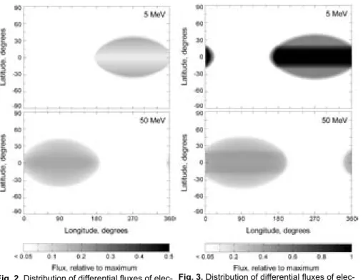
Distribution of differential fluxes of electrons with energies 5 and 50 MeV on Europa's surface considering their guiding center motion in Jupiter's magnetosphere and larmor motion near Europa. Distribution of differential fluxes of electrons with energies 5 and 50 MeV at 100 km altitude considering their guiding center motion in Jupiter's magnetosphere and larmor motion near Europa.
CALLISTO – MAGNETOSPHERE INTERACTIONS
The unique environment on the surface of Europa must be taken into account to maximize the potential science yield and engineering success. Knowledge of the surface topography and composition is essential for mission safety and selection of scientifically interesting landing sites. As a result, the trailing hemisphere of Europa is bathed in charged particles trapped in the co-rotating Jovian magnetic field.
Dalton, J.B., Linear mixture modeling of Europa's non-ice material based on cryogenic laboratory spectroscopy, GRL 34:L21205, 2007.
AQUEOUS SOLUTIONS UNDER PRESSURE AS Potential haBitats
Alexeev, Scobeltsyn Institute of Nuclear Physics, Lomonosov Moscow State University, Leninskie Gory, 119992, Moscow, Russia
EFFECTS OF SECOND APPROXIMATION OF THE fiGUre theory for JUPiter’s satellite io
EFFECTS OF SECOND APPROXIMATION
LAPLACE – EUROPA LANDER MISSION architectUre
Characterize the chemistry of the non-ice material on Europa's surface, particularly in terms of habitability and biosignatures. On the 2nd stage, the optimal trajectory will consist of the several gravity assists using Ganymede. In addition, estimates have been made of the radiation impact in the near-Earth and interplanetary parts of the mission orbit.
Bottom chart - example of optimal gravity assist strategy in the Jupiter system.

MISSION DESIGN FOR A LOW-RADIATION EUROPA lander
SEARCHING FOR LIFE IN EXTREME
However, the frozen substance creates a uniform surface of Europa, due to which the entire shell begins to rotate. In this work we examined how stresses, initiated by tidal effects, would affect a discrete area of Europa's ice surface with an elongated melt on the frontal tectonic ridge. By analyzing the appearance of the destruction and the propagation zones depending on the type of applied load, the defects appearing on the surface of Europa's ice can be classified.
Using locally homogeneous models of thawed ice patches in the distributed temperature field, the effect of mechanical gravity-tidal forces on the formation of surface defects in Europe was studied.
LASER-INDUCED PLASMA SPECTROSCOPY for IN-SITU cheMical analysis for lander