I currently work within the Wildland Research Institute (WRi) in the School of Geography in the University of Leeds. WRi will provide advice and training on GIS and spatial analysis tools for planning biodiversity corridors in the La Primavera Biosphere Reserve and adjacent areas. The course covered the basics of grid-based modeling (local, focal, zonal and global functions) and helped develop a broader understanding of the capabilities of ArcGIS and raster analysis in the context of terrain and hydrologic modeling.
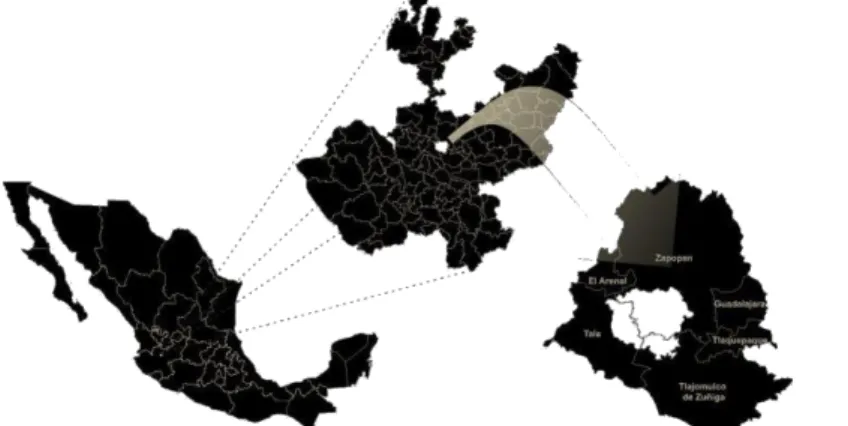
In May, I was invited to a presentation with my data in the class of one of Dr. In summary and according to the objectives of the scholarship, I have acquired new knowledge in the field of GIS through the use of new programs and have been active in applying these and the experience gained by observing the activities of nature and environment agencies in the UK, in my area of interest in the state of Jalisco and La Primavera Biosphere Reserve. Due to the increasing amount of economic infrastructure required by the growing population of the city and surrounding area of Guadalajara, the pattern of natural ecosystems in the Jalisco region of Mexico is becoming increasingly fragmented.
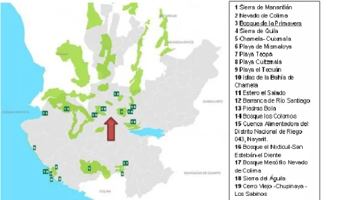
This has the immediate effect of increasing the isolation of the La Primavera Biosphere Reserve, Guadalajara's closest protected area, with associated reductions in relation to other protected areas elsewhere in the region. In the Mexican state of Jalisco, the human population continues to grow in an uncontrolled manner. We propose a working approach for the restoration of the affected areas that allows a comprehensive management of these natural environments and improves the resilience of the ecosystem in the center of the state of Jalisco.
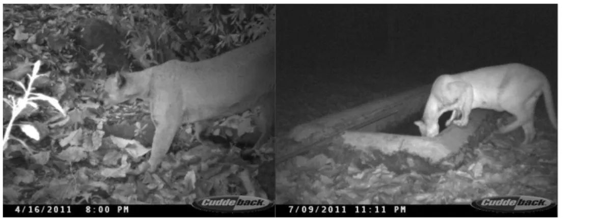
Local monitoring in the La Primavera area carried out in 2011 revealed 33 deaths of various animals (both wild and domestic) during a period of one month along.
Aims and Objectives
Selection of data sets
Methods
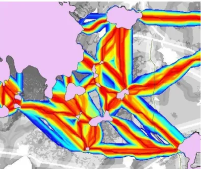
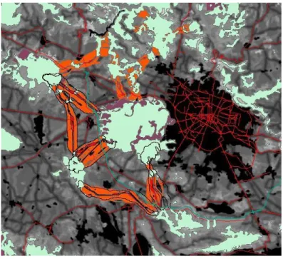
Identifying pinch points & barriers
This tool is then used to perform additional analysis on the raster data of the natural landscape links for the specified modeling runs to highlight critical points within these natural landscape links. Although the use of state-of-the-art corridor modeling tools has enabled detailed modeling of habitat suitability and potential wildlife corridors and bottlenecks between protected areas and puma habitat, there is still considerable uncertainty about the validity of these results. Our knowledge of puma habitat preferences and behavior is limited to field observations and surveys, while the models themselves are limited by the quality of data and assumptions made in generating output.
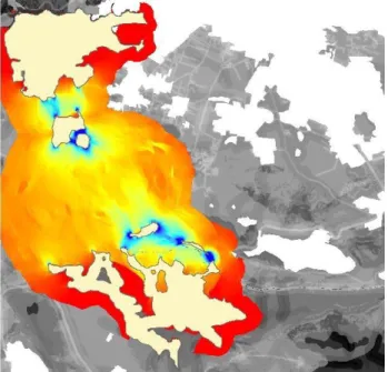
While the results shown below in Figures 7-9 are very detailed and based on the best tools available, there is still uncertainty as to whether they accurately represent true cougar habitat preferences and behavior. This paper presents additional analyzes based on participatory surveys of local GIS populations to attempt to validate the results of HSM and corridor modeling. The online participatory GIS (PGIS) system "Map-Me" is used to conduct surveys of area residents for a month to compare information on cougars sightings and signs, livestock predation, and likely impacts of land use, people, and infrastructure on behavior, disturbance, and mortality cougars.
Me is a fuzzy PGIS that uses a spray can interface over a Google Map base that allows users to spray "paint" on the areas of the map they want to comment on in relation to questions posed in the survey (e.g. "Please spray on the map areas you saw puma or puma signs") and then comment on the areas defined in response to specific contextual questions using free-form text boxes (e.g. "When was the last time you Seen a puma or puma signs in this area? "). The spray patterns are stored as dot shape files (each blob of paint in a separate dot) so that large amounts of data on spatial patterns can be collected in a relatively short period of time. The answers to the contextual questions are also stored, but are crucially linked to the spray patterns so that they can be used to generate a rich picture of local knowledge about various aspects of puma behavior and habitat.
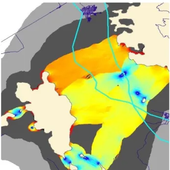
This information was used to develop a better understanding of local residents' perceptions of the cougar and how the construction of ecological underpasses and bridges under/over the new highway may affect wildlife conservation. Spatter patterns are mapped using kernel density filters to show the general pattern and frequency of local knowledge (see Figure 11).
Results
Map-Me results showing local knowledge of puma sightings and signs While the models in Figure 11 necessarily remain at this stage due to their large scale, further work is probably required to add further local detail based on surveys further in the field of local knowledge and According to opinion, it can be seen that there are some distinct patterns linking the results from the corridor design work and the knowledge of local people. The core of the biosphere reserve appears very clearly as the puma's main habitat according to local residents and reserve workers. While there is no data to support the presence of local knowledge of puma presence and habitat in Cerro Viejo and Tepopote, this is likely due to a lack of response from people in these areas for political and personal reasons.
However, at the scale of the entire La Primavera and its surrounding protected areas it can be seen that information collected using PGIS can be useful in validating and confirming the presence and pattern of puma habitats and potential migration corridors , thus supporting the presented spatial analysis. above. How good these models are at identifying the location and detailed pattern of corridors and associated points in the field is open to debate. It is suggested here that further field surveys with local residents, land managers and conservation professionals are essential in validating the details of the models and therefore better supporting decisions about the best placement of expensive capital infrastructure, such as wildlife bridges and underpasses, especially when funding for these is limited and it is essential that these are built in the best possible place.
Discussion
Conclusions and recommendations
A Proactive Agenda
Maintaining native vegetation cover and initiating reclamation activities for bare areas and various natural reforestation. To the Darwin Initiative for the great opportunity they gave me with this Fellowship and the kind people of the University of Leeds. And finally for all those who want to "connect" - build bridges, partnerships and cooperatives. to all who believe in conservation.. we are on the same side of life.
Linking models of wildlife habitat and human development to predict the future distribution of cougar habitat.Ecosphere, 1(1), art4. 2013. Selection, evaluation and testing of methods for identifying priority connectivity conservation areas: a case study in the Pyrenees. Thesis submitted to the Center for Mountain Studies, University of the Highlands and Islands, in partial fulfillment of the degree of Master of Science in Sustainable Mountain Development.
Documento electrónico [fecha de consulta 2014] Available in: < http://www.conanp.gob.mx/que_hacemos/>. Dickson BG, Roemer GW, McRae BH, Rundall JM (2013) Models of regional habitat quality and connectivity for Pumas (Puma concolor) in the Southwestern United States. Effectiveness of natural protected areas to prevent land use and land cover change in Mexico's biodiversity and conservation.
Ley General del Equilibrio Ecológico y la Protección al Ambiente, 2007 LGEEPA, México: Diario Oficial de la Federación. Comparison and development of new graph-based landscape connectivity indices: towards prioritizing habitat patches and corridors for conservation. Rudnick, D. A., et al. 2012, The role of landscape connectivity in planning and implementing conservation and restoration priorities.
Secretaría de Medio Ambiente y Recursos Naturales, SEMARNAT, 2000, Programa de Manejo del Área de Protección de Flora y Fauna La Primavera, México. Norma Oficial Mexicana NOM-059-SEMARNAT-2010, Protección Ambiental-Especies nativas mexicanas de flora y fauna silvestres-Categorías de riesgo y especificaciones para su inclusión, exclusión o modificación-Lista de especies en riesgo. A., 2009, La conexión forestal de las áreas protegidas del estado de Jalisco con otros ambientes naturales.
![Fig ure 3. Biosphere Area Zonation (After Netherlands National Commission for UNESCO) Comment [KA1]: Ref?](https://thumb-eu.123doks.com/thumbv2/pubpdforg/19403504.0/10.894.81.707.375.709/biosphere-area-zonation-netherlands-national-commission-unesco-comment.webp)