PART I: PROJECT INFORMATION
Project Title: Enhancing Sustainability and Climate Resilience of Forest and Agricultural Landscape and Community Livelihoods
Country(ies): Bhutan GEF Project ID:1 9199
GEF Agency(ies): UNDP GEF Agency Project ID: 5713
Other Executing Partner(s): Gross National Happiness Commission - Secretariat
Submission Date: 14 March 2017, 10 June 2017 GEF Focal Area (s): Biodiversity, Sustainable Forest
Management
Project Duration (Months) 72
Integrated Approach Pilot IAP-Cities IAP-Commodities IAP-Food Security Corporate Program: SGP
Name of Parent Program N/A Agency Fee ($) 1,257,041
A.
FOCAL AREA STRATEGY FRAMEWORK AND OTHER PROGRAM STRATEGIES2 Focal AreaObjectives/Programs Focal Area Outcomes Trust
Fund
(in $) GEF
Project Financing
Co-financing
CCA-1 Reduce vulnerability of people, livelihoods, physical assets and natural systems
LDCF 4,950,000 10,000,000 CCA-2 Strengthen institutional and technical capacities for
effective CCA
LDCF 4,950,000 10,000,000 CCA-3 Integrate CCA into relevant policies, plans and associated
processes
LDCF 600,000 6,000,000
BD -1 Programme 1 Increased revenue for protected area
systems and globally significant protected areas to meet total expenditures required for management; improved management effectiveness of protected areas
GEFTF 2,311,416 10,000,000
SFM - 2 Increased application of good management
practices in all forests by relevant government, local community (both women and men) and private sector actors
GEFTF 1,155,708 6,630,300
Total project costs 13,967,124 42,630,300
1Project ID number remains the same as the assigned PIF number.
2 When completing Table A, refer to the excerpts on GEF 6 Results Frameworks for GETF, LDCF and SCCF.
GEF-6 FULL-SIZED PROJECT FOR ENDORSEMENT
PROJECT TYPE:FULL-SIZED PROJECT
TYPE OF TRUST FUND:LDCF/GEFTRUST FUND /MULTI TRUST FUND For more information about GEF, visit TheGEF.org
B. P
ROJECT DESCRIPTION SUMMARYProject Objective: Operationalizing an integrated landscape approach through strengthening of biological corridors, sustainable forest and agricultural systems, and building climate resilience of community livelihoods
Project Components/
Programs
Financing
Type3 Project Outcomes Project Outputs Trust
Fund
(in $) GEF Project Financing
Confirmed Co-financing Component 1:
Institutional capacity for integrated landscape management (ILM) and climate change resilience
TA Enhanced institutional capacity for integrated management of forests, biodiversity and ecosystem services, increasing climate resilience and building a conducive environment for biological corridor network operationalization, indicated by:
- National Forest Monitoring System incorporates HCVF and carbon stock assessment;
- National protocols established for habitat and biodiversity monitoring in PAs and BCs;
-Ecosystem valuation piloted in the project landscapes Strengthened planning framework for the biological corridor system:
-Biological Corridor (BC) system mapped in detail based on results of delineation review and included in comprehensive integrated landuse plans;
Increased forest areas under sustainable management practices, indicated by the GEF
1.1: Strengthened policy and planning frameworks and institutional capacity for integrated landscape
management and climate change resilience within key national agencies, including decision support tools for holistic and comprehensive integrated landuse planning through zonation for the project landscapes, and refinement of the BC system delineation in relation to connectivity, HCVF, traditional land management, climate change adaptation and sustainability criteria;
1.2: Strengthened monitoring systems for forest condition, biodiversity status and carbon stocks in DoFPS, including strengthened National Forest Inventory (NFI) and National Forest Monitoring System (NFMS) to measure status and condition of forest and carbon stocks, integration of the HCVF concept, protocols and capacity for monitoring habitats and biodiversity;
1.3: Sustainable financing system for biological corridor and PA system and sector-oriented valuation policy and tools developed to measure ecosystem services benefits, including a sustainable financing strategy for the national PA/ BC system, lessons shared for upscaling
PES/REDD+ schemes, test ecosystem valuation tools and conduct awareness programme on ecosystem values;
1.4: Strengthened national systemic and institutional capacity for management of the biological corridor and PA system, including revised Biological Corridor Regulations, strategic plan for operationalizing the BC system including a reporting system, staffing standards, training and mechanisms for engagement of local
GEF TF LDCF
1,554,000 BD: 354,000 SFM: 600,000 LDCF: 600,000
Total:
10,000,000 GEF TF Cofinancing:
4,800,000 LDCF Cofinancing:
5,200,000
3 Financing type can be either investment or technical assistance.
SFM Tracking Tool:
-100,000ha forest area brought under sustainable and climate- resilient management practices;
Improved financial
sustainability of PA/biological corridor management:
- Financing gap of US$4,447,000 to achieve basic management of targeted PAs/BCs is closed and management of PAs/BCs more self-reliant through use of at least two new financial sources, GEF BD1 TT Sustainable Financing score of 75%;
Institutional framework and capacity strengthened for integrating climate change concerns and adaptation options into local governance:
- Mainstreaming Reference Group (MRG) system strengthened and operating sustainably with guaranteed budget at central and dzongkhag level (12 dzongkhags)
stakeholders in BC/PA management, national awareness raising of the BC system;
1.5: Planning and monitoring capacity for sustainable forest management in FMUs and LFMPs, including:
updated planning, implementation and monitoring guidelines with new inventory data management system, training and equipment, field studies and lab analysis for inventory data management, mobility and field
equipment/ instruments to FRMD and TFDs in for enhanced planning and monitoring, 1 new and 6 updated FMU management plans, and LFMPs for 33 gewogs;
1.6: Institutional mechanisms and tools strengthened for integration of Climate Change Adaptation (CCA) and environmental sustainability needs in local development planning system at dzongkhag and gewog levels, through strengthened central and local Mainstreaming Reference Group system, and increased local government capacity for use of mainstreaming tools and integrate CCA and environmental issues into plans and programmes, capacity for SEA increased and SEA conducted for key sector-led development policies, programmes and plans affecting the project landscapes
Component 2:
Emplacement of BC system governance and management system at pilot corridors
TA Increased management effectiveness of the project landscapes consisting of 4 biological corridors and 3 contiguous PAs as per GEF BD-1 Management Effectiveness Tracking Tool for each
management unit, indicated by:
-increased METT scores for three PAs (1,149,400ha) and four BCs (176,400ha):
JKSNR:62>75 JSWNP:66>75
2.1: Conservation management plans (CMPs) integrating CCA needs in place for the four BCs in the target project landscapes including review, demarcation and mapping of BC boundaries, increased capacity of WCD and TFDs for biodiversity and socio-economic survey methods that integrate CCVA into CMPs, prepare a climate-adaptive CMP for BC8 and incorporate CCA into CMPs for BCs 1,2 & 4 at Mid-term stage;
2.2: Governance operationalized and management effectiveness enhanced for the targeted BCs, including strengthened personnel capacity and sustainable financing, basic infrastructure (e.g. signage, patrol/
camping sites and outposts, boundary pillars) and
GEF TF 1,900,000
BD: 1,399,636 SFM: 500,364
Total:
8,320,000 GEF TF Cofinancing:
8,320,000 LDCF Cofinancing:
0
PNP:73>80 BC1:35>65 BC2:26>65 BC3:32>65 BC8:20>65
Status of key species:
- Key species (tiger, musk deer, snow leopard) populations stable or increased over baseline level in PAs. Sightings of animals or indirect signs of animals
(droppings, pug marks etc.) using BCs stable or increased compared to MTR level;
Biodiversity threat reduction:
- Reduction in threat cases reported over the project period in project landscapes:
Human Wildlife Conflict (HWC):
50% reduction in proportion of HHs affected by crop and livestock depredation over baseline in targeted areas;
Poaching: cases reduced by at least 50% of baseline
Forest Fires: number and area reduced by at least 50% of baseline.
GHG emission reduction:
- 3,578,372tCO2eq direct GHG emissions avoided over 10 yrs owing to improved forest area management and sustainable land management as calculated using FAO-EXACT.
equipment, awareness of local stakeholders raised, METT system introduced for BCs;
2.3: Law enforcement and biological monitoring capacity increased for key ecosystems for threatened species in the target BCs and adjoining PAs, through SMART
patrolling and strengthened biological monitoring system, participation of local communities mobilized for
monitoring and reporting of biodiversity conditions and threats, and inter-agency coordination and enforcement mechanisms;
2.4: Sustainable human wildlife conflict response strategies developed and systems strengthened through innovative mechanisms based on global best practices in the target BCs and adjunct PAs, revision of the Bhutan National HWC Management Strategy 2008, implement HWC responses in hotspots in the BCs and adjoining PAs, evaluate and scale-up best practices.
Component 3: INV Livelihood options for at least 3.1:Strengthened climate resilience and productivity of LDCF 9,154,000 Total:
Climate Adaptive Communities
TA 70% of population in project landscapes made more resilient to climate risks, indicated by:
-At least 25% increase in annual household incomes associated with project interventions over
baseline,
-At least 30% increase over baseline number of people adopting sustainable livelihood activities;
-At least 50% increase over baseline quantity of climate resilient infrastructure;
-All project area households aware of gender roles and women’s role in HH decision making or consultation;
-Women’s contribution to
productive work increased to 75%
over baseline;
Sustainable land and water resource management instituted in targeted landscapes through community-based and gender- equitable SLM, SFM and climate- smart agriculture practices indicated by:
2000ha under SLM,
38 SFM groups and 100,000ha forest under SFM,
Increased no. of water sources protected, and
Erosion rate values for reference plots (bare), traditional practices and SLM practices (t/ha/yr) at each site.
agricultural and livestock management, including: SLM interventions including traditional practices to enhance climate resilience and reduce land degradation, climate- smart agriculture, watershed management, and irrigation interventions, low-emission livestock practice
management through enhanced management of grazing land and fodder production, stall feeding and breed improvement, and enhanced institutional capacity at dzongkhag and gewog levels for related extension services;
3.2: Community livelihoods improved and sources of income diversified and enhanced in the target landscapes, including: strengthened value addition in supply chains of priority climate resilient commodities;
commercialization of organically-produced farm produce through cooperatives system; community-based crop and livestock insurance schemes piloted in selected hotspot areas, including capacity building at Dzongkhag and community level (GECC) for potential climate risk transfers; protection of watershed areas to safeguard environmental services (PES, PWS and REDD+) through water source protection, support to community forestry and water users’ associations, and conservation livelihood opportunity development;
3.3: Transformation of market access is demonstrated for selected rural communities to enhance their climate resilience, including climate-resilience guidelines for roads, demonstrated CCR improvements to prioritized Gewog Connectivity roads, post-harvest storage and packaging and processing and sales facilities developed to improve marketing infrastructure,
improved rural community access to market and weather/climate information, including commodity prices, and improved capacity of farmers to recognize market risks, linkages and explore opportunities (access to market) to maximize value addition in the supply chains.
GEF TF
LDCF:
8,854,000 BD: 300,000
19,000,000 GEF TF Cofinancing:
1,580,000 LDCF Cofinancing:
17,420,000
Component 4:
Knowledge Management and M&E
TA Effective knowledge management, indicated by:
Information sources, best practices, lessons learned &
remaining knowledge gaps on ILM/CCR practices in Bhutan including all project results available online,
Series of case studies presenting project-supported best practices and traditional knowledge of ILM /CCR,
Biodiversity portal with updated comprehensive information on the PAs and BCs, including detailed GIS maps of BCs;
Reports on project achievements and best practices on gender mainstreaming, and
Project lessons learned fully documented and made available online.
Mid-term review and final evaluation conducted in time
4.1: Institutionalized knowledge for ILM and Climate Change Resilience, through review and documentation of existing information and lessons on ILM and climate change resilience, strengthened institutional base(s), human and financial resources for long-term knowledge management system, and strengthened biodiversity portal with information on PAs and BCs, including upgraded and detailed maps of the BCs;
4.2: Enhanced generation, documentation and sharing of knowledge and best practices in ILM and climate resilient livelihood practices, through: implementation of the project communications strategy, dissemination of case studies including traditional knowledge, gender roles and traditional grievance redress mechanisms for resolving resource management disputes, focus group discussions and exchange visits, develop and manage project website and share learning on gender mainstreaming and SESP integration;
4.3: Project monitoring and evaluation system in place and used to inform project management decision-making.
This includes: inception workshop, annual planning workshops, monitoring of activities, outputs and outcomes, monitoring of the risk matrix and identifying potential risks and mitigation measures to reduce those unexpected risks; a project impact evaluation to capture the causal impacts of the project towards its stated outcomes; quality assurance according to UNDP requirements; Mid-term Review and Terminal Evaluation.
LDCF GEF TF
695,000 LDCF:
500,000 BD:
195,000
Total:
2,000,000 GEF TF Cofinancing:
700,000 LDCF Cofinancing:
1,300,000
Subtotal 13,303,000 39,320,000
Project Management Cost (PMC)4 LDCF 664,124 Total:
4 For GEF Project Financing up to $2 million, PMC could be up to10% of the subtotal; above $2 million, PMC could be up to 5% of the subtotal. PMC should be charged proportionately to focal areas based on focal area project financing amount in Table D below.
GEF TF
LDCF: 546,000 BD:
62,780 SFM:
55,344
3,310,300 GEF TF Cofinancing:
1,230,300 LDCF Cofinancing:
2,080,000 Total project costs 13,967,124 42,630,300
C.
CONFIRMED SOURCES OF CO-FINANCING FOR THE PROJECT BY NAME AND BY TYPEPlease include evidence for co-financing for the project with this form.
Sources of Co-financing Name of Co-financier Type of Cofinancing Amount ($)
GEF Agency UNDP Grant 1,080,300
Recipient Government GNH Commission Grant 7,360,000
Recipient Government GNH Commission In kind 1,570,000
Recipient Government MoAF Grant 22,490,000
Recipient Government MoAF In kind 3,520,000
Recipient Government MoWHS Grant 6,610,000
Total Co-financing 42,630,300
D. T
RUSTF
UNDR
ESOURCES REQUESTED BY AGENCY(IES), COUNTRY(
IES)
AND THEP
ROGRAMMING OFF
UNDSGEF Agency
Trust
Fund Country Focal Area Programming of Funds
(in $) GEF
Project Financing
(a)
Agency Fee
a) (b)2
Total (c)=a+b
UNDP LDCF Bhutan N/A N/A 10,500,000 945,000 11,445,000
UNDP GEF
TF
Bhutan Biodiversity N/A 2,311,416 208,027 2,519,443
UNDP GEF
TF
Bhutan SFM SFM 1,155,708 104,014 1,259,722
Total Grant Resources 13,967,124 1,257,041 15,224,165
a ) Refer to the Fee Policy for GEF Partner Agencies
E. PROJECT’S TARGET CONTRIBUTIONS TO GLOBAL ENVIRONMENTAL BENEFITS5
Provide the expected project targets as appropriate.
Corporate Results Replenishment Targets Project Targets
1. Maintain globally significant biodiversity and the ecosystem goods and services that it provides to society
Improved management of landscapes and seascapes covering 300 million hectares
1,304,958 hectares
2. Sustainable land management in production systems (agriculture, rangelands, and forest landscapes)
120 million hectares under sustainable land management
100,000 hectares
3. 4. Support to transformational shifts towards a low-emission and resilient development path
750 million tons of CO2e mitigated (include both direct and indirect)
3,578,372tCO2 eq
B.
F.D
OES THE PROJECT INCLUDE A “NON-GRANT” INSTRUMENT?
NO
(If non-grant instruments are used, provide an indicative calendar of expected reflows to your Agency and to the GEF/LDCF/SCCF Trust Fund) in Annex D.
PART II: PROJECT JUSTIFICATION
A.
DESCRIBE ANY CHANGES IN ALIGNMENT WITH THE PROJECT DESIGN WITH THE ORIGINAL PIF6A.1. Project Description.
1) the global environmental and/or adaptation problems, root causes and barriers that need to be addressed;
There has been no significant change in the nature of the problem that the project is seeking to address. It has been further elaborated along the following lines. See project document Development Challenge (section II, pp6-21) for details.
7.
The development challenge that this project seeks to address concerns the adverse impacts of climate change on rural livelihood security (SDG 13) and poverty (SDG 1), and the effects of sector-led development practices on the ecological integrity of biodiversity-rich forested landscapes (SDG 15). Bhutan’s renewable natural resource (RNR) sector, which is made up of agriculture, livestock production and forestry forms a significant part of the national economy, as the largest employer with 58 percent of the working population, and with agriculture contributing 16.7 percent to the national economy in 2015. However, the RNR sector is very vulnerable to climate change impacts, which have been increasing as a result of heavy rainfall, drought, frost, hailstorms, windstorms and related land degradation. In addition to climate-related losses, damage to crops and livestock from wildlife causes major production losses. Bhutan’s biodiversity resources are of regional and global significance and the preservation of intact, forested landscapes through the protected areas network and associated biological corridors is needed to sustain these values. However, climate change impacts and other anthropogenic threats such as land conversion, forest fires, infrastructure development and unsustainable agriculture are placing increasing pressure on biodiversity and the integrity of ecosystems in the country. The relationships between the various levels of indirect factors and direct factors and the targets for the project intervention are illustrated in the conceptual model in Fig. 4, which also identifies the main entry points for the project intervention strategies.
5 Update the applicable indicators provided at PIF stage. Progress in programming against these targets for the projects per the Corporate Results Framework in the GEF-6 Programming Directions, will be aggregated and reported during mid-term and at the conclusion of the replenishment period.
6 For questions A.1 –A.7 in Part II, if there are no changes since PIF , no need to respond, please enter “NA” after the respective question.
7Substantial additional information is available in Annexes 18, 19 and 21
The long-term solution envisaged by the project is to ensure the effective climate resilient management of forest areas including biological corridors and adjoining protected areas, securing ecosystem services that underpin livelihoods, local and national development and climate change adaptation (CCA). However, there are several barriers that need to be overcome: 1) Insufficient institutional capacity for integrated landscape management (ILM) and CCA; 2) Insufficient capacity to operationalize the biological corridor system; 3) Limited capacity, awareness and support for building livelihood resilience; and 4) Inadequate knowledge on natural resource status, ecosystem services and resilient livelihood options.
2) the baseline scenario or any associated baseline projects
There has been no significant change in the baseline scenario or associated baseline projects, with the exception of the project’s formerly anticipated engagement with the Rural Economic Advancement Programme (REAP) Phase II village-level development planning process using a culture-based, gender sensitive and environment friendly approach. During PPG consultations, GNHC-S indicated that REAP is still in a pilot stage and the village development planning process is not ready for upscaling through this project. Consequently, the project will instead focus on strengthening the Mainstreaming Reference Group approach as a means of mainstreaming climate change adaptation, environmental management, gender mainstreaming and other cross sectoral issues into local development planning. Lessons will still be drawn from REAP in the planning and implementation of local development and livelihood activities under this GEF/LDCF project. (See paras 33 and 34 of Development Challenge on p15, Table 3 and Annex 28 of project document).
Further information on the baseline situation is given in the Project Document Development Challenge Section II (pp14-16) and Results section IVi (pp.27-28; 32; 36-37; 44-45)
3) the proposed alternative scenario, with a brief description of expected outcomes and components of the project
The project components can be summarized as follows:
Outcome 1:
Enhanced institutional capacity for integrated landscape management (ILM) and climate change resilience: this component will focus on building institutional capacities for ILM as well enhancing climateresilience across rural communities. Specifically, it will incorporate biodiversity conservation objectives and safeguards and climate change concerns in the land use and natural resource use planning and management process, aiming to catalyse an economically and ecologically optimal land use mix and practices in the biological corridors and neighbouring landscapes.
Outcome 2: Biological corridor (BC) governance and management established and demonstrated with management
linkage to adjoining PAs: this component will enable the RGoB to operationalize four BCs in the project landscapesthrough the development of climate-smart conservation management plans and the development of technical capacity and basic infrastructure, including strengthened biological monitoring and law enforcement systems and human-wildlife conflict management interventions to address threats including encroachment and poaching in conjunction with adjoining PAs in the project landscapes.
Outcome 3:
Livelihood options for communities are made climate-resilient through diversification, SLM and climate-smart agriculture and supported by enhanced climate-resilient infrastructure: this component supportscommunities and service providers to enhance climate resilience of livelihoods by optimizing and diversifying production, adding post-production value and improving sustainable access to markets. In addition, it will demonstrate how climate change adaptation and biodiversity conservation as well sustainable forest management objectives can jointly be addressed, creating synergistic impacts for sustainable local development.
Outcome 4:
Knowledge management system established to support sustainable management of forest and agricultural landscapes and climate-resilient communities:through this component, the project will ensure that
information and knowledge accumulated and produced within the project will be documented and made available
for wider communication and dissemination of project lessons and experiences to support the replication and scaling-up of project results.
See Results Section IVi (pp.27-46)
During project preparation the following principal changes have been introduced – the table below summarizes the changes made, and the rationale for these changes, to the Outcomes and Outputs from the PIF.
Project/
Outcomes
PIF GEF CEO ER Rationale
Component 1
Four outcomes specified in the PIF project framework
Five outcomes specified in CEO ER Table B. These are consistent with the PIF outcomes, with the exception that the following PIF outcome has been changed from:
Institutional framework and capacity strengthened at village level, for integrating climate change concerns and adaptation options into sub-national levels, indicated by:
i) climate change concerns integrated into VDP planning process add output; ii) VDP planning linked to overall sub- national planning process to:
Institutional framework and capacity strengthened for integrating climate change concerns and adaptation options into local governance:
- Mainstreaming Reference Group (MRG) system strengthened and operating sustainably with guaranteed budget at central and dzongkhag level (12 dzongkhags)
Outputs have been revised, including the following significant changes:
Addition to Output 1.1 of TA including decision support tools for holistic and comprehensive
integrated landuse planning through zonation for the project landscapes.
Addition of Output 1.5: Planning and monitoring capacity for sustainable forest management in FMUs and LFMPs
Revision of Output 1.6 to focus on strengthening of the MRG system as opposed to upscaling the REAP project’s village development planning approach
The change in outcome to focus on strengthening of the MRG system as opposed to upscaling the REAP project’s village development planning approach follows the intervention of GNHC-S during PPG consultations, noting that the VDP process was not ready for upscaling through this project as it is still at pilot stage. The MRG system, on the other hand, is a very appropriate vehicle for mainstreaming climate change adaptation, environmental management, gender and other cross-sectoral issues into local governance. The same rationale applies to revision of Output 1.6.
The addition to Output 1.1 came at the request of the Implementing Partner (GNHC-S) during PPG consultations, which will strengthen the
integration of the BC system into national land use planning, thus helping to head off
fragmentation of the corridors by conflicting land uses.
Output 1.5: Planning and monitoring capacity for sustainable forest management in FMUs and LFMPs has been added to strengthen the project’s intervention in support of SFM practices, through building capacity of the DoFPS for incorporating biodiversity and carbon monitoring, and
supporting the development and updating of management plans for FMUs and LFMPs, incorporating CCA.
Other changes are largely a question of presentation of the project intervention logic in the Theory of Change and Results Framework.
The indicators in the Results Framework plus the GEF BD-1, CCA and SFM Tracking Tools cover the PIF outcomes and outputs.
Component 2
Four outcomes specified in the PIF project framework
Four outcomes specified in CEO ER Table B. These are consistent with the PIF outcomes.
Other PIF outcomes reflected as indicators in the RF
Outputs have been revised
No significant change in scope of this component from the PIF – although see next point regarding the design of the project landscapes.
Current revisions are largely a question of presentation of the project intervention logic in the Theory of Change and Results Framework.
The indicators in the Results Framework plus the GEF BD-1, CCA and SFM Tracking Tools cover the PIF outcomes and outputs.
During the PPG, baseline assessments,
consultations and analysis informed refinement of the outputs to deliver the operationalization of the targeted BCs on the ground through the
Territorial Forest Departments in association with the associated PAs.
All
Components
In Component 2, the PIF makes reference to on the ground support for three biological corridors (BCs) of importance to breeding tigers, and targeted support for at least 2 PAs in the larger corridor landscape.
Meanwhile the PIF mentions that component 3 will select at least 10 Dzongkhags for support according to criteria including REAP priority areas, and presence of BCs. No geographical areas are specified, although potential BCs and PAs are listed.
Three project landscapes
encompassing four BCs (1,2,4 and 8) and three PAs (JSWNP, JKSNR and PNP) across the centre of the country have been defined, totaling 1,304,958 ha and covering parts of 38 gewogs in 12 dzongkhags.
Further details are given below including a map of the project landscapes. See also Project Document Annex 18 for the landscape profiles and Annex 24 for population and land cover information for the project landscapes
During the PPG, the project landscapes were defined through a consultation process with stakeholders, documented in UNDP’s reports on the PPG workshops. The final project landscapes greatly exceed the PIF plans, in that they cover four (not three) BCs, and a total of 1,304,958 ha (vs 350,000 ha), with tiger present in at least three of these BCs. They also cover parts of twelve (vs ten) dzongkhags associated with the BCs.
Component 3
Three outcomes specified in the PIF project framework
Two outcomes are given in the CEO ER – the third in the PIF has been combined with the first one, so the substantive content remains.
PIF outcomes are reflected as indicators in the RF.
The PIF outcome for livelihood options made more resilient for at least 155,000 people, while a projected total of 96,400 people reside in the project landscapes, some 70% of which are anticipated to benefit from the project
livelihood resilience interventions.
Outputs have been revised
No significant change in the scope of this component from the PIF, with the exception of the number of direct project beneficiaries for resilient livelihood options. The PIF outcome total of 155,000 is accompanied by the following footnote: This estimate is based on the rural population of 10 dzongkhags and assuming 65%
of the population is reached by the project. The selection of the communities will be undertaken during the PPG and this estimate will be revised.
Detailed assessment of the populations of the 38 gewogs within 12 dzongkhags of the project landscapes (all are within or immediately adjacent to BCs) was unable to exceed a projected total 96,400 people (comprising some 11.8 percent of the projected national population of 818,370), some 70% of which are targeted to benefit from project livelihood resilience interventions. While
this is a lower figure, it is considered realistic for the project context of sparsely populated
mountain landscapes. See project document Annex 24 for details.
Other changes are largely a question of presentation of the project intervention logic in the Theory of Change and Results Framework.
The indicators in the Results Framework plus the GEF BD-1, CCA and SFM Tracking Tools cover the PIF outcomes and outputs.
During PPG, baseline assessments, consultations and analysis informed refinement of the outputs.
Component 4
None New Outcome 4: Knowledge
management system established to support sustainable management of forest and agricultural landscapes and climate-resilient communities
Given the UNDP/GEF recommendations regarding the importance of improving knowledge and sharing lessons learned from project interventions systematically, a new outcome has been introduced into the project design. This also has budgetary implications (see below).
Budget revisions
C1: USD 1,350,000 C2: USD 2,000,000 C3: USD 9,953,000
C1: USD 1,554,000 C2: USD 1,900,000 C3: USD 9,154,000 C4: USD 695,000
Budget reallocations in line with the above described programming priorities were undertaken. The most significant change is the addition of Component 4, with funds being drawn for knowledge management and M&E from the other Components. The budget for Component 1 was increased in order to include Output 1.5 in support of SFM interventions and additional land use planning support in Output 1.1.
In addition, the project duration has been increased from 5 to 6 years (72 months). See the text below for the rationale for this change,
Rationale for Extending the Project Implementation Period to Six Years
It is proposed to extend the planned duration of the project from five to six years in order to provide optimal conditions for achieving the project outcomes. This is a large and complex project that involves considerable logistical challenges in the context of a small country with limited government capacity. The main considerations are as follows:
1. Firstly, the current project is the only project that has integrated GEF Trust Fund and LDCF financing and while it is the first of its sort, this involves tackling administrative complexities and uncertainties which might delay its implementation.
2. Secondly, the implementation of the project will be decentralized to twelve project districts for the first time. Further, we learnt that during the Government’s forthcoming 12th Five Year Plan which will span the project duration, one of their focus areas will be on decentralization, whereby the implementation of all related plans will be fully decentralized. While this is a worthy initiative, we are equally concerned about the capacities of local government to implement not just their planned program but our project as well.
3. Thirdly, the implementation phase of this project will encounter three major elections whereby most government officials will be engaged in electoral processes and that are likely to delay project implementation, as evident from past experience. The following elections will take place during this project’s implementation period:
i. National Council/Upper House Election: Year 2018
ii. National Assembly/Lower House Election: Year 2018 [after National Council Election]
iii. Local Government & Thromde (municipal) election: Year 2021
In addition to national level elections, every district has its own local festivals and events whereby Local
Government Officials are engaged or on holidays. Therefore, since implementation is being decentralized, such local festivals and events will also affect our project implementation.
4. Further, this project will be implemented over two different plan periods (11th Five Year Plan and 12th Five Year Plan). Therefore, there may be certain things that might need to be adjusted as there may be several issues such as changes in project staff (particularly government counterparts), re-structuring of agencies, etc. which we may have to factor into our risks.
5. Finally, Bhutan being situated in fragile mountain ecosystem, most roads remain blocked during monsoon season (June to early August) thus restricting movement of goods and slowing down implementation. In most cases, physical activities are on halt during the monsoon due to inaccessibility.
Overall, the above factors will hinder project delivery, therefore the project duration should be adequate to fully complete the project and to realize its objectives.
Project Management Staff Capacity
For such a large and complex project, it is considered essential to have adequate project management capacity to ensure that coordination is effective with the numerous related government units at all levels and other stakeholders, and that operations proceed in an efficient manner with due attention to UNDP and GEF project management, reporting and M&E requirements. The PMU has been designed in a highly cost-effective manner, making full use of the cofinancing contributions of the key project partners as follows.
There are only three LDCF financed PMU staff positions, as follows:
1. Project Officer – RGoB Contracted 2. M&E Officer – RGoB Contracted
3. Project Technical Specialist – UNDP Contracted
From the government side, there will be the following cofinanced staff;
1. Project Manager from GNHC (the Implementing Partner) 2. Project Accountant also from GNHC
3. Component 1 Manager from Policy and Planning Division, Ministry of Agriculture and Forests (MoAF) 4. Component 2 Manager from Department of Forest and park Services, MoAF
5. Component 3 Manager from Local Development Division, GNH Commission.
Component 4 will be handled by the PMU.
Since the PMU will be housed in the GNH Commission, the project will use GNHC’s procurement and finance personnel in addition to the above-mentioned PMU staff (both project hired and government co-financed staff) following government procurement guidelines and systems.
For any complex procurement of both services and equipment, UNDP CO has signed Country Office Support Services (COSS) agreement with the government, whereby government will request UNDP CO’s services (see Project Document Annex 11).
This PMU staffing capacity is considered to be adequate, and the strong commitment of GNH Commission has been given to ensure effective implementation. Once the project has been approved, the project activities will be
integrated into the Annual Performance System (APA) which is managed by Government Performance Management Division (GPMD) under the Prime Minister’s Office. All responsible agencies will be signing performance
agreements with respective sector heads, including individuals responsible for implementing the activities of this
project. Their performance will be rated annually based on their Individual Work Plan (IWP) which will include the
implementation of this project.
Over and above this, the UNDP Country Office in Bhutan will be providing technical assistance and oversight to ensure effective implementation as per the Project Document (Governance and Management Arrangements section).
Further, it was also discussed and agreed during the LPAC meeting that the PMU strength will be reviewed after one year to determine whether the present proposed strength is appropriate to achieve effective implementation.
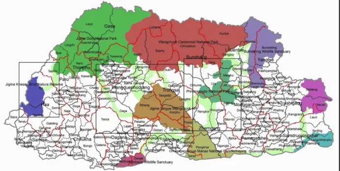
Landscape Scoping and Rationale
The primary rationale for the selection of the project landscapes in the central belt of the country is based on the need to strengthen the ecological network connecting protected areas in the northern third of the country with those in the centre and south of the country (Figs. 1&2) – in other words, biological corridors that generally follow the alignment of river valleys and intervening ridges. This is of great importance for key wildlife species such as the tiger, leopard, snow leopard and elephant with large ranges. In particular, Bhutan is regarded as key source population for the tiger across the Himalayan range and this project will be of great significance in supporting national and global tiger recovery plans.
The project landscapes contain some of the finest representational samples of a continuum of ecosystems, connecting the largely subtropical zone of southern Bhutan and the predominantly sub-alpine/ alpine zone of northern Bhutan. These landscapes, with proper conservation management plans in operation and sustainable livelihoods in practice, will cushion the adverse impacts of climate change to key development sectors and local livelihoods and enhance the ecological resilience to changing climate and associated risks.
Figure 1. Bhutan’s national PA and BC System
Figure 2. Locations of the project landscapes (boxes) superimposed over the PA and BC network The three landscapes
8identified by the names of the protected areas and biological corridors (Figs. 1 & 2) are:
Landscape 1, covering Jigme Khesar Strict Nature Reserve and Biological Corridor 1, in the west of the country;
Landscape 2, covering Jigme Singye Wangchuck National Park and Biological Corridors 2 and 8, in the central- west;
Landscape 3, covering Phrumsengla National Park and Biological Corridor 4, in the central-east.
Figure 3. Gewog level Climate Change Vulnerability Map within the landscape areas (Source: PPG Climate Change Vulnerability Assessment Report – See Annex 19).
A climate change vulnerability assessment was conducted for the proposed project landscapes during the PPG
8 See Annex 24 for Population and land cover information for the project landscapes
process (see Annex 14). Assessment of vulnerability was done at chiwog level, then upscaled to gewog level. The assessment at the landscape level was then made based on the average score of gewogs within each landscape. The vulnerability scores for the sampled gewogs are shown in Fig. 3. Combined scores indicated that Landscape 1 in the west was least vulnerable, Landscape 2 in the centre was less vulnerable and Landscape 3 in the east was most vulnerable. Changes in summer temperature, windstorm and rainfall patterns are the major factors that contribute to the score in exposure index at the landscape level. Landscape 1 is the most affected by changes in rainfall and windstorm while Landscape 2 is affected the most by changes in winter temperature and hailstorm. Landscape three is the most affected by changes in summer temperature and flood. Thus, changes in exposure are highly localized in view of Bhutan’s highly dissected topography and corresponding climatic variations. The CCVA results have informed the prioritization of livelihood interventions under the project, which will be fine-tuned during the project inception phase.
A further strategic consideration is the need to avoid overlap with related landscape level initiatives. The selected project landscapes generally complement these initiatives, which respectively focus on the southern, northern and eastern parts of Bhutan, as follows: a) WWF’s Trans-boundary Manas Conservation Area (TRAMCA) project (2012-2015), which supports transboundary areas in southern Bhutan with India and Nepal; b) World Bank-GEF Sustainable Financing for Biodiversity Conservation and Natural Resources Management Project (GEF-5), which aims to improve the operational effectiveness and institutional sustainability of the Bhutan Trust Fund for Environmental Conservation (BTFEC) and improve conservation management of the High Altitude Northern Areas (HANAS) landscape; and c) IFAD’s Commercial Agriculture and Resilient Livelihoods Enhancement Programme (CARLEP) ($31.526 million, over seven years), which aims to promote climate smart approaches in agriculture and strengthen capacities of communities and local institutions in six eastern Dzongkhags with high production and marketing potential in the selected value chains. In addition, the project will coordinate with the transboundary ICIMOD Kangchenjunga Landscape Conservation and Development Initiative (KLCDI)
9, which overlaps with Landscape 1 in the west of the country including Jigme Khesar Strict Nature Reserve. See Annex 28 for details.
The total area covered by the project landscapes is 1,304,958 hectares (ha), or 13,049.58 km
2, which is a little more than one-third of the country’s total geographical area. Forest is by far the most dominant land cover accounting for 75.3 percent (982,873 ha) of the total area in the project landscapes. Agriculture area accounts for only a tiny 1.6 percent (20,057 ha) as large areas of the landscapes are characterized by rugged terrain, wilderness and high altitudes. In total, the three landscapes cover 12 dzongkhags and 38 gewogs, see Annex 24. While the selection of the three project landscapes is based on the location of the PAs and BCs along the central belt of the country, the project will cover the gewogs (that have areas within the PAs/BCs) in their entirety especially for the climate- resilient community livelihoods component, thus expanding the landscapes beyond the boundaries of the identified PAs and BCs. Local communities living on the fringes and outside the PAs/BCs have access to, and often significantly depend on, natural resources in the PAs/BCs for their subsistence and livelihoods.
See Development Challenge pp11-14.
4) incremental/additional cost reasoning and expected contributions from the baseline, the GEFTF, LDCF, SCCF, and co-financing;
There were no significant changes in the incremental/additional cost reasoning and expected baseline contributions from the PIF and no change in total amounts of GEF TF and LDCF funds.
There was a minor increase in the total amount of parallel cofinancing, from $41,900,000 to $42,630,300. This was also reflected in changes in the distribution of cofinancing sources in the PIF, with $41,550,000 sourced from various national and local government units through GNHC-S, and $1,080,300 from UNDP. See Table 7 in Project Document.
5) global environmental benefits (GEFTF) and/or adaptation benefits (LDCF/SCCF); and
9 See: http://www.icimod.org/kl
The primary global environmental benefits that will be delivered include the mainstreaming of biodiversity and ecosystem service conservation and climate change resilient livelihoods over a landscape of 1,304,958 ha, some 75.3 % of which is under forest cover, 9.7% shrub cover, a mere 1.6% agricultural land (due to the rugged terrain), and the remainder meadows, rocky terrain and snow 13.4%. 176,400 ha lies in the four BCs and 324,405 ha in the three associated PAs, thus totalling 500,805 ha of land within the national protected areas system (including the BCs). This far exceeds the PIF target of 350,000 ha of globally significant landscapes under improved management.
The project’s climate smart agriculture and sustainable land management interventions will target SLM practices in at least 2,000 ha (some 10% of the agricultural land within the project landscapes), and SFM implementation will be supported over at least 100,000 ha of FMUs, LFMP areas and CF areas within the landscapes, in line with the PIF target. Sustainable forest management and forest conservation is anticipated to result in avoided GHG emissions of some 3,578,372tCO
2eq over 10 years, exceeding the PIF target of 3,084,953 tCO
2eq.
Baseline practices Alternative to be put in place by the project Global environmental benefit Forest landscape planning and management
Forest protection and forest resource use planning is based on the limited forest inventory data without taking into account ecosystem values and biodiversity, leading to continued forest
degradation and loss of ecosystem functions
Narrow sectoral approach prevails in terms of land use decision making; forest planning does not incorporate SFM tools.
National policies do not provide sufficient incentives and support mechanisms for forest land use optimization to sustain resource resilience nor do they allow implementation of a multiple-use forest landscape planning and management concept
Insufficient human and financial resources for conducting regular and integrated forest, biodiversity and socioeconomic inventory and assessment.
Mainstreaming SLM/SFM principles and landscape approach into provincial and district and community land use planning and
development planning in biological corridors, compliance monitoring and enforcement:
-Land use decisions are made with full consideration for biodiversity and ecosystem values of the landscape, ecosystem integrity of the large multiple use forest landscapes ensuring biological corridor functions, and climate change adaptation needs of people and ecosystems;
- Land use compliance is monitored and enforced by the established corridor governance body with full participation of the local
stakeholders from different sectors;
- SFM is implemented through strengthened National Forest Inventory data management, incorporation of biodiversity and carbon stocks in implementation of the National Forest Monitoring System and consideration of High Conservation Value Forests (HCVF) in forest functional zoning;
Degraded areas are actively managed and restored for habitat enrichment and to create areas conducive for movement and dispersal of wild fauna and flora as well as counteract ongoing and past land degradation;
- Communities are fully engaged in forest and natural use planning and management, with access to a range of incentives and support;
- Human and financial resources secured for required data collection and applications.
SFM and BD benefits Pressures on forest and shrub landscapes (1,109,631 ha) reduced:
-Well-functioning ecosystem services ( increased water quality and quantity, reduced extent and severity of floods, higher carbon sequestration and tourism value) providing positive contributions to national economy and local livelihoods;
-Future commercial forestry and agriculture initiatives integrate ecosystem services values and biodiversity concerns in their
management and are only allocated to areas where economic value clearly outweighs that of ecosystems and biodiversity, and does not compromise the connectivity of forest complexes ensuring the full value of forest ecosystems are maintained.
- Production forests integrate the concept of HVCFs and climate change adaptation in their management plans.
See GEF BD1 Tracking Tool (Project Document Annex 4a)
See GEF SFM Tracking Tool (Project Document Annex 4c)
Protected Area Management Protected areas will continue to be
under-resourced resulting in suboptimal management effectiveness.
Biological corridors will remain as
“paper corridors” with no governance and management
Protected area – biological corridor multiple- use forest landscape management is
operationalized, with corridor management plans that are compatible with local land use plans, governance structure and required staffing and financing, and with necessary capacity for managing the corridor areas benefitting both biodiversity and ecosystem
BD Benefits:
Improved financial sustainability of protected area system including corridor management
operationalization, closing the existing funding gap.
Increased management effectiveness in
structure and activities. Corridors are not able to fulfil intended functions, resulting in habitat degradation and loss of connectivity between protected areas due to agricultural activities and over exploitation of natural resources.
Degraded forest areas in important Wildlife Corridors are not restored.
Disconnect between corridor management and local level land use planning and practices persist, exacerbating human wildlife conflict.
maintenance/enhancement and local livelihoods. Technical skills for SMART patrolling, biological monitoring, community engagement and outroll of national METT+
system strengthened for PA and TFD staff.
Protected areas and biological corridors are fully integrated in the land use plans of dzhongkhags and gewogs, providing conducive landscape and land use practices that support maintenance of biodiversity and ecosystem services.
Incentives for communities to refrain from unsustainable forest use created through application of various incentive and support systems, including alternative livelihood support schemes such as conservation job creation and high value non-wood forest product development and marketing.
Emplaced effective enforcement and
monitoring systems in three existing protected areas covering 324,405 ha and in the four biological corridors covering 176,400 ha.
the existing PAs in the PA/corridor landscapes measured by the METT See GEF BD1 Tracking Tool )Project Document Annex 4a)
Increased or stable numbers of tiger, snow leopard and musk deer Reduction of threats to biodiversity from human wildlife conflict and poaching and illegal wildlife trade, and forest fires.
SFM Benefits
Mitigated emission of 3,578,372 tCO2eq over a 10 year period from improved forest area management and sustainable land management, and strengthening of PA management. Identification and monitoring of area high conservation value forest within project landscapes
Capacity development for SFM within local communities to support
community forestry practices Supporting sustainable finance mechanisms for SFM such as PES, PWS and REDD+.
See GEF SFM Tracking Tool (Project Document Annex 4c)
Community Livelihood resilience Rural development support
programmes do not fully take into account climate vulnerability resulting in only short term measures for livelihood enhancement and local development.
Community support projects are carried out in isolation from PA and corridor landscapes and their functions, resulting in loss of opportunities for strengthening resilience of “ecological infrastructure” which supports community adaptation efforts.
Awareness and capacity installed among supporting organisations and corridor community members about the need for integrating resilience in their thinking and practices, leading to actual on-the-ground actions for resilience strengthening – such as more resilient landscape planning to ensure connectivity and continued provision of essential ecosystem services, diversification of livelihoods, value addition to crop and forest products, development of supply chains, establishment of community ranger system.
Climate resilience is introduced to rural livelihood options through investment in resilient irrigation design, soil protection/
management in steep slopes, and diversification of agricultural production.
Clear linkages will be formed between community livelihood support and biodiversity conservation interventions, as well as
adaptation benefits, demonstrating synergistic impact.
Adaptation Benefit
Resilience of ecosystem services and natural assets enhanced under climate change and other stresses. This includes stability in the area and conditions of ecosystems of importance for ecosystem based adaptation, climate risk management and connectivity.
Community capacity for climate change adaptation strengthened with diversified and climate change resilient livelihoods, and sources of income diversified and increased in targeted areas.
See GEF Climate Change Adaptation Tracking Tool (Project Document Annex 4b)
Biodiversity Benefit
Biodiversity mainstreamed in forest- agricultural landscape management (over 100,000 ha).
Local Agricultural Development
RGoB programmes places a more emphasis on intensification of agriculture and building hard infrastructure than ensuring continuous water supply, and it will likely to result in increased
incidences of small water sources sometimes run out and farmers abandon the irrigation channels, and ultimately, farmlands.
Agricultural production
enhancement support such as the provision of power tillers, seeds and extension services is rendered almost independently from addressing the extremely high soil erosion. Changes in rainfall patterns in the future, especially extreme rainfall following a dry spell, can trigger even greater runoff washing away important nutrients in soils.
Production enhancement will be carried out without due
consideration for maintenance of essential ecosystem services and biodiversity conservation, resulting in suboptimal return on investment due to negative impact on natural capital.
MoAF places a significant emphasis on agricultural
marketing, commercialization and private sector engagement.
Howeverthese efforts, physical access to markets (and other public services) is constantly interrupted during and after the monsoon season as they are almost always unpaved, dirt roads.
The Environmentally Friendly Road Construction standard is only applicable to national highways and other major roads, and it is practically impossible, financially and technically, for dzongkhags and gewogs to adhere to the standard for the construction of lesser roads.
Private sector engagement continues to be significantly limited in scope and budget of government programmes, and builds on the notion of production intensification rather than diversification.
RGoB will explore the option of tapping more abundant water in larger rivers often located in gorges.
Agricultural production will enhanced by investing in land development (i.e. terracing) and construction of small-scale check dams to maximize the value of the baseline
development projects.
Complimentary to climate-smart agricultural practices and SLM, the project will support low-emission livestock practice management and enhanced management of grazing land and fodder production.
Agricultural production will be diversified in the same gewogs where intensification support is also provided by the government.
National and sub-national governments has improved capacity for integrating climate adaptation and biodiversity objectives in agricultural development
Markets and market accessibility will be enhanced in support of rural climate resilient livelihood options. Value chain analyses are carried out focusing on several key products.
Over and above the conventional analysis, these will include additional elements such as increased risks of erratic rainfall and
temperature during the post-harvest stage or locally-specific bottlenecks in physical access to markets with additional flood/landslide risks.
Road design will be improved and made more resilient by adding design elements specifically to enhance the structural integrity of these roads so critical in ensuring continuous access to markets. Those elements include drainage, cross drainage and black-topping over existing roads. For ensuring sustainability of such measures, appropriate technologies are introduced within the realm of the existing financial and technical capacity of sub-national administrations. LDCF resources will also be used to produce a simplified EFRC standard that is more suitable for sub-national administrations given their technical and financial constraints.
Adaptation Benefit
Climate resilience of rural livelihood options enhanced through investment in resilient irrigation design, soil protection/management in steep slopes, and diversification of agricultural production.
SLM (2,000ha), low-emission livestock management, improved grazing land and agro-forestry (1,000ha).
Value-chains, markets and market accessibility strengthened in support of rural climate resilient livelihood options.
Strengthened institutional framework and capacity at local levels for integrating climate risks related to rural livelihoods.
See GEF Climate Change Adaptation Tracking Tool (Project Document Annex 4b)
Biodiversity Benefit Biodiversity internalised in agricultural development and
agricultural landscape management in biodiversity rich forest dominated landscapes.
See Project Document Section III Strategy paras 58 and 59 and Table 1 on pages 25 and 26.
6) innovation, sustainability and potential for scaling up.
These sections have been elaborated during the PPG. See Project Document section III Strategy, p25 Innovativeness section; and section V iv on Sustainability and Scaling Up (p61)
A.2. Child Project? If this is a child project under a program, describe how the components contribute to the
overall program impact.
N/A
A.3. Stakeholders. Identify key stakeholders and elaborate on how the key stakeholders engagement is
incorporated in the preparation and implementation of the project. Do they include civil society organizations (yes /no )? and indigenous peoples (yes /no )?
10During the course of project preparation (PPG phase) all key project stakeholders were identified and extensive stakeholder consultations were conducted at all levels, including field visits to communities and meetings with gewog, dzongkhag and central government agencies, CSOs and technical experts. A full record of stakeholder consultations was maintained during the PPG phase and this has been annexed to the UNDP/GEF Project Document (Annex 13). Based on stakeholder analysis, a stakeholder engagement plan was developed and annexed to the UNDP/GEF Project Document (Annex 27). This table mapping stakeholder engagement by project output is also included in section A.3.
The project stakeholders include both civil society organizations and indigenous people. The table of key stakeholders notes that Tarayana Foundation will have a potentially key role for social mobilization and outreach to local communities for improved livelihoods including those that are more resilient to climate change; RSPN will have a potentially key role in terms of raising community awareness and understanding of environmentally sustainable and climate-resilient livelihoods, and innovative approaches of integrated conservation and development including community-based eco-tourism. RSPN is active in Phobjikha, a critical wetland that is home to black- necked cranes in winter, which is a part of the project landscape II (JSWNP+BC2+BC8). WWF will be a key project partner in view of their longstanding support to biodiversity conservation in Bhutan especially in the protected areas and biological corridors and for synergy and linkages with Bhutan for Life, a long-term collaborative scheme between RGoB and WWF to mobilize and operationalize sustainable financing for the protected areas/
biological corridors system. Particular areas of technical support from, and partnership with, WWF include enhancement of management effectiveness of biological corridors and protected areas (through Bhutan METT+
system), conservation management planning in the biological corridors integrating CCA needs, SMART patrolling, and human-wildlife conflict management. The stakeholder engagement table in section A.3 notes that WWF will be involved in implementing Outputs 1.3, 1.4, 2.1, 2.3 and 2.4; CSOs including Tarayana Foundation and RSPN will be involved in Output 3.2.
In the on-going formulation of 12
thFive Year Plan for Bhutan, there is strong commitment from the government to engage CSOs in the developmental programmes. One key purpose of the 12
thFive Year Plan Guideline is: “The
Guideline is also expected to serve as a central reference document for all actors in nation building, including the various political parties and institutions, development partners, CSOs, as well as the private sectors.”Furthermore, 23 CSOs were recognised for their service to the national and awarded National Order of Merit-Gold during the National Day Celebration in 2016 December which is clear indication of active and impactful role played by the CSOs. (http://www.bbs.bt/news/?p=64578 ).
10 As per the GEF-6 Corporate Results Framework in the GEF Programming Directions and GEF-6 Gender Core Indicators in the Gender Equality Action Plan, provide information on these specific indicators on stakeholders (including civil society organization and indigenous peoples) and gender.
The implementation of the GEF-LDCF-financed project will be based on extensive engagement with stakeholders at all levels across the project landscapes. The tables below list the project stakeholders at all levels and their main roles and responsibilities during implementation. At a broad level, participation and representation of stakeholders will be conducted through the governance structures put in place by the project as outlined and depicted in the organogram in the Governance and Management Arrangements (Project Document section VII), and through the existing structures at national and local/ field levels (e.g. central-level departments and agencies, Territorial Forestry Divisions, Protected Area Management Authorities, and Dzongkhag Administrations). Stakeholders will be consulted and engaged throughout the project implementation phase to: (i) promote understanding of the project’s outcomes; (ii) promote stakeholder ownership of the project through engagement in planning, implementation and monitoring of the project interventions; (iii) communication to the public in a consistent, supportive and effective manner; and (iv) maximisation of linkage and synergy with other ongoing projects.
Outcome/ Output Stakeholders Key Responsibilities
Outcome 1: Enhanced systemic and institutional capacity for integrated landscape management and climate change resilience Output 1.1: Strengthened policy and
planning frameworks and
institutional capacity for integrated landscape management and climate change resilience within key national agencies
PPD/MoAF Oversight, coordination and facilitation of the process, and mobilization of inter-sectoral and sectoral participation and inputs.
Various departments and agencies within and outside MoAF, NEC-S
Participation in the policy and planning process and institutional capacity assessment, and timely delivery of sectoral inputs.
GNHC-S Participation in the policy and planning process, ensuring that the frameworks are consistent with overall national policies and plans.
Output 1.2: Strengthened monitoring systems for forest condition,
biodiversity status and carbon stocks in DoFPS
DoFPS/ MoAF Coordination of the development of the systems, and subsequent operationalization and management of the systems
Output 1.3: Sustainable financing system for biological corridor and PA system and sector-oriented valuation policy and tools developed to measure ecosystem services benefits.
PPD/ MoAF Oversight, coordination and facilitation of the process, and instatement of policy and tools
DoFPS/ MoAF Technical inputs to the process, and implementation of the policy and tools
WWF Bhutan Technical support and guidance, and linkage with Bhutan for Life
Output 1.4: Strengthened national systemic and institutional capacity for management of the biological corridor and PA system
WCD/ DoFPS/ MoAF Oversight, coordination and facilitation of the process, and mobilization of participation and inputs from relevant agencies within and outside the department
WWF Bhutan Technical support and guidance UWICE/ CNR Provider of training services Output 1.5: Planning and monitoring
capac