GEF 6 Cameroon Integrated Landscape Management PIF 1
PART I: P
ROJECTI
NFORMATIONProject Title: Removing barriers to biodiversity conservation, land restoration and sustainable forest management through COmmunity-BAsed LAndscape Management – COBALAM
Country(ies): Cameroon GEF Project ID:1 9604
GEF Agency(ies): UNEP GEF Agency Project ID: 01442
Other Executing Partner(s): Ministry of Environment, Nature Protection and Sustainable Development of Cameroon (MINEPDED) with support of Rainforest Alliance
Re-Submission Date: October 22, 2010
GEF Focal Area(s): Multi-focal area Project Duration (Months) 60
Integrated Approach Pilot IAP-Cities IAP-Commodities IAP-Food Security Corporate Program: SGP
Name of parent program: Agency Fee ($) 294,977
A.
INDICATIVEF
OCALA
REAS
TRATEGYF
RAMEWORK ANDO
THERP
ROGRAMS
TRATEGIES2 Objectives/Programs (Focal Areas, Integrated Approach Pilot, CorporatePrograms) Trust Fund
(in $) GEF Project
Financing
Co-financing
BD-4: Program 9 GEFTF 1,931,324 6,750,000
LD–2 Program 3 GEFTF 586,850 6,500,000
LD-3 Program 4 GEFTF 586,849 5,750,000
Total Project Cost 3,105,023 19,000,000
B.
INDICATIVEP
ROJECT DESCRIPTION SUMMARYProject Objective: Enable improved biodiversity conservation and sustainable landscape and forest management through participatory community-based natural resource management (CBNRM) and local enterprise development
Project Components
Financing
Type3 Project Outcomes Project Outputs Trust Fund
(in $) GEF Project
Financing
Co-financing Component 1:
Community forest protection and institutional alignment for integrated landscape management
TA/Inv Outcome 1.1.
Improved protection status for 4,000 ha of High Conservation Value Forest/Key Biodiversity Area (HCVF/KBA)
managed by communities (i.e.
Sacred Forest) in the Western Highlands of Cameroon (WHC), and clear cross-sector coordination
mechanisms for integrated landscape management
Output 1.1.1 Legal and technical frameworks for attributing conservation status to identified HCVF/KBA managed by communities in the WHC developed based on stakeholder consultations submitted to designated authorities and approved
Output 1.1.2 Existing Inter- institutional landscape management bodies strengthened in two priority landscapes in WHC involving multi-sector and multi-scale stakeholder groups
Output 1.1.3 Frameworks to institutionalize participatory
GEFTF 500,000 2,794,520
1 Project ID number will be assigned by GEFSEC and to be entered by Agency in subsequent document submissions.
2 When completing Table A, refer to the excerpts on GEF 6 Results Frameworks for GETF, LDCF and SCCF.
3 Financing type can be either investment or technical assistance.
GEF-6 PROJECT IDENTIFICATION FORM (PIF) P
ROJECTT
YPE:
FULL SIZE PROJECTT
YPE OFT
RUSTF
UND: GEF TRUST FUND
GEF 6 Cameroon Integrated Landscape Management PIF 2
sustainable landscape management are developed, including mechanisms to incentivize local CBNRM enterprise submitted to designated authorities and approved
Component 2:
Capacity and incentives development to support HCVF/KBA management and SLM and SFM deployment
TA/Inv Outcome 2.1 Pressures on natural resources from competing land uses on natural forests covering 25,000 ha are reduced through integrated natural resource management planning and capacity development of farmers and communities in the
WHC and South Region
Output 2.1.1 Land-use and management plans in three priority landscapes covering 46,000 ha containing HCVF/KBA in the WHC and South region
Output 2.1.2 At least 10 local CSOs and 3,000 farmers and communities in the WHC and in the South of Cameroon, trained on recognized SLM and SFM practices through customized technical assistance
Output 2.1.3 Market and policy incentives identified and leveraged to motivate application of SLM and SFM practices in the WHC and in the South of Cameroon
Output 2.1.4 At least 5 exchange trips and 5 workshops among key stakeholders organized to identify best practice, share new impact insights, and improve governance and enterprise in CBRNM in Cameroon.
GEFTF 1,000,000 5,589,040
Component 3:
Deployment of integrated SLM and SFM practices in WHC and South Region landscapes
TA/Inv Outcome 3.1
Landscape level uptake of SLM/SFM measures avoids and reduces land degradation and biodiversity loss delivering ecosystem and development benefits over 42,000 ha in the WHC and South Regions
Output 3.1.1 SLM and SFM practices identified in the landscape management plans are implemented with local CSOs and CBOs through a small-grants approach in the WHC Region and South Region
Output 3.1.2. Gender-disaggregated indicators to assess ecological, socioeconomic impacts of HCVF/KBA protection, SLM and SFM practices are developed, and monitored with local stakeholders.
GEFTF 1,457,165 9,615,068
Subtotal 2,957,165 17,998,628 Project Management Cost (PMC)4 147,858 1,001,372 Total Project Cost 3,105,023 19,000,000
C. I
NDICATIVE SOURCES OFC
O-
FINANCING FOR THE PROJECT BY NAME AND BY TYPE,
IF AVAILABLE Sources of Co-financing Name of Co-financier Type of Co-financing Amount ($) National Governments Ministry of Environment, Nature Protection and
Sustainable Development of Cameroon (MINEPDED) In-Kind 500,000
4 For GEF Project Financing up to $2 million, PMC could be up to10% of the subtotal; above $2 million, PMC could be up to 5% of the subtotal. PMC should be charged proportionately to focal areas based on focal area project financing amount in Table D below.
GEF 6 Cameroon Integrated Landscape Management PIF 3
National Governments Ministry of Environment, Nature Protection and
Sustainable Development of Cameroon (MINEPDED) Cash 1,500,000
National Government
North West Grass Field Development Program, North West Development Authority of Cameroon (MIDENO), Ministry of Agriculture and Rural Development of Cameroon (MINADER)
Cash 8,800,000
National Government
Program for the Improvement of Competitiveness of Family Agro-pastoral Farms (ACEFA), Ministry of Agriculture and Rural Development of Cameroon (MINADER)
Cash 5,000,000
CSO Rainforest Alliance In-Kind 1,400,000
CSO African Center for Renewable Energy and Sustainable
Technologies (ACREST) Cash 500,000
CSO ERuDEF Cash 1,000,000
Private Sector Cabinet Patoke In-Kind 300,000
Total Co-financing 19,000,000
D. I
NDICATIVET
RUSTF
UNDR
ESOURCESR
EQUESTED BYA
GENCY(
IES),
C
OUNTRY(
IES)
AND THEP
ROGRAMMING OFF
UNDS a) GEFAgency Trust Fund
Country/
Regional/
Global
Focal Area
Program ming of Funds
(in $) GEF
Project Financing
(a)
Agency Fee (b)b)
Total (c)=a+b
UNEP GEFTF Cameroon Biodiversity 1,931,324 183,476 2,114,800
UNEP GEFTF Cameroon Land Degradation 1,173,699 111,501 1,285,200
3,105,023 294,977 3,400,000 a) Refer to the Fee Policy for GEF Partner Agencies.
E.
P
ROJECT PREPARATION GRANT(
PPG)
5Is Project Preparation Grant requested? Yes No If no, skip item E.
PPG
A
MOUNT REQUESTED BY AGENCY(
IES), T
RUSTF
UND,
COUNTRY(
IES)
AND THEP
ROGRAMMING OF FUNDSProject Preparation Grant amount requested: $91,325 PPG Agency Fee: $8,675 GEF
Agency
Trust Fund
Country/
Regional/Global Focal Area Programming of Funds
(in $) PPG (a)
Agency Fee6 (b)
Total c = a + b
UNEP GEFTF Cameroon Biodiversity 56,804 5,396 62,200
UNEP GEFTF Cameroon Land degradation 34,521 3,279 37,800
Total PPG Amount 91,325 8,675 100,000
F.
P
ROJECT’
ST
ARGETC
ONTRIBUTIONS TOG
LOBALE
NVIRONMENTALB
ENEFITS7Provide the expected project targets as appropriate.
Corporate Results Replenishment Targets Project Targets
Maintain globally significant biodiversity and the ecosystem goods and services that it provides to society
Improved management of landscapes covering 300 million hectares
4,000 hectares
Sustainable land management in production 120 million hectares under sustainable land 42,000 hectares8
5 PPG requested amount is determined by the size of the GEF Project Financing (PF) as follows: Up to $50k for PF up to$2m (for MSP); up to
$100k for PF up to $3m; $150k for PF up to $6m; $200k for PF up to $10m; and $300k for PF above $10m. On an exceptional basis, PPG amount may differ upon detailed discussion and justification with the GEFSEC.
6 PPG fee percentage follows the percentage of the Agency fee over the GEF Project Financing amount requested.
7 Provide those indicator values in this table to the extent applicable to your proposed project. Progress in programming against these targets for the projects per the Corporate Results Framework in the GEF-6 Programming Directions, will be aggregated and reported during mid-term and at the conclusion of the replenishment period. There is no need to complete this table for climate adaptation projects financed solely through LDCF and/or SCCF.
GEF 6 Cameroon Integrated Landscape Management PIF 4
systems (agriculture, rangelands, and forest landscapes)
management
PART II
:
PROJECTJ
USTIFICATION1. Project Description. Briefly describe:
a. The global environmental and/or adaptation problems, root causes and barriers that need to be addressed Global environmental and adaptation problems
1. Cameroon’s biodiversity endowment is stunning. It is home to an estimated 8,300 plant species, 335 mammal species, 913 bird species, and 542 fresh and brackish water fish species. One of
the most ecologically diverse countries in the world, the country counts a high degree of endemism. Nearly half of the bird and mammal species of Africa are present in Cameroonian forests, and the country counts a full 92% of Africa’s ecosystems; thus Cameroon is often referred to as “Africa in miniature.”
2. The Western Highlands of Cameroon (WHC)9 forms part of the Cameroon Highlands ecoregion (WWF Global 200 - see description in Annex 2) which runs south-west to north-east through western Cameroon and adjacent south-east Nigeria. This mountainous region extends into the Gulf of Guinea to the island of Bioko (or Fernando Po), which is part of Equatorial Guinea (see Figure 1 and 2). The WHC ecoregion includes the highest peaks in West Africa (Mt. Cameroon 4095 m; Mt. Oku 3010 m; Pico Basilé 3011 m) and comprises unique montane ecosystems, with threatened fauna and flora. The terrain of the Western Highlands agro-ecological zone consists mainly of plateaus and areas of depression ranging from 1,000 to 2,300 m above sea level. The annual rainfall varies from approximately 1,300 mm in the plains to over 3,000 mm on highland peaks (Yengoh, 2012).
3. Over 80% of the active population is involved in farming. Farms are generally small in size, approximately 0.5 to 2 hectares per family. The economy of the WHC relies heavily on agriculture, as there are relatively few alternative sources of employment.
Although intensive to semi-intensive in many places, cultivation techniques are characterized by rudimentary tools, use of family labor and constantly decreasing farm sizes. The general cultivation system is spread over two annual cycles, where perennial crops (Arabica coffee, fruit) often appear in combination with annual crops. Extensive areas are also covered by tea and tobacco.
4. Cameroon’s South region offers a stark contrast to the WHC. The South is dominated by lowland tropical rainforest. While forest cover has been largely maintained, much of the forest has been subject to commercial logging for decades. Today, unlogged forest is located only in a handful of nature reserves – most notably the Dja Biosphere Reserve (covering 5,260 km²) and the Campo Ma’an National Park (2,640 km², on the border with Equatorial Guinea). While industrial logging concessions cover a majority of the forest area in the South region, some 50 community forests have also been recognized over the last 20 years, covering almost 300,000 ha (MINFOF, 2011). Although considerable progress has been made in the region’s community forests, burdensome bureaucratic requirements, a lack of social, organizational and enterprise capacity, limited finance, and weak market pull for products issued from sustainable community forests has hindered the development of this model.
8 21,000 ha of agropastoral lands in WHC and 21,000 ha of community forests in the South
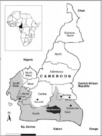
9 In administrative terms, within Cameroon, the WHC covers parts of the following regions: West, South-West, North-West, and Adamawa. The present project will work only in the West and North-West regions. For simplicity, proposed interventions in potential focal landscapes are discussed under the broad term “WHC.”
Figure 1. Cameroon and its 10 regions. The approximate spatial extent of the actual forest area is shaded in light grey.
Source: Mertens, 2000
GEF 6 Cameroon Integrated Landscape Management PIF 5
5. Conservation of the South region’s forests is a national, regional and global priority. The tropical forests in the region support abundant wildlife, including some of Cameroon's last populations of chimpanzees, gorillas, and elephants. More numerous still are a diversity of smaller primates, bats, and birds.
Other common wildlife species include pangolins, porcupines and other rodents, as well as genets. Many of these species are becoming increasingly rare due to wildlife poaching and habitat fragmentation through deforestation and forest degradation. Over the last 20 years, community forestry has been encouraged across Cameroon, and particularly in the South region, as a means to increase participation in the management of forest resources, and expand benefits from sustainable, locally-based forestry. Such increased participation has potential to improve conservation and livelihood outcomes, while increasing legal sources of timber and non-timber forest products for national and international markets.
At present, the South counts about 17% of all recognized community forests in Cameroon. Yet the development of community forestry in the region, advanced as it is for the Congo Basin, is still highly incipient. If this model is to be a sustainable counterpoint to large-scale industrial logging and commercial plantations, significant support will be needed to build local capacities and leverage market and policy incentives for community-based forestry.
Key environmental threats include10:
Unsustainable agricultural practices and soil erosion:
6. The use of the low-lying wetlands for irrigated crops is growing, while having an impact on the hydrological regime of
rivers. Cultivation on steep slopes and clearing by fire are widespread throughout the area, contributing to erosion and loss of soil fertility (PAN/LCD, 2006). Most of the agricultural activity takes place during the rainy season since the region is very poorly equipped with irrigation infrastructure. Limited water holding capacity of soils means that they cannot provide much- needed moisture during periods of drought and long dry spells that are increasingly common. In addition, low-input subsistence farming that replaces the natural vegetation has led to a rapid depletion of plant nutrients. Economic constraints limit the use of inorganic fertilizers for a majority of the small-scale farmers. The limited maintenance of soil health has led to a general stagnation of yields for most food crops over the last three decades. Cases of reasonable yield growth per hectare for most major food crops in the region are limited, notwithstanding the large yield gaps that exist between farmers’ yields and optimal yields (Yengoh, 2012).
Increased competition in land use:
7. Traditionally, the area of the WHC had dual agricultural and pastoral functions, located in the slopes, plains and lowlands for agriculture, and peaks and volcanic zones for pastoral uses. The region still comprises 14% of the national cattle herd. However, pastoral space is shrinking in favor of agriculture: the area under cultivation has increased by nearly 40% between 1990 and 2005, while at the same time, the pasture has decreased by 37%. Overgrazing and conflicts between farmers and grazers are the most visible signs of increased competition for spaces and degradation of pastoral resources (PAN/LCD, 2006).
8. Land-use pressures are growing, sustained by strong population growth in the region. Vegetation cover is in permanent decline due to agricultural expansion. Forest reserves in the North-West region were created between 1934 and 1961. Since then, no other reserves have been established apart from the Oku Sanctuary, which today has the status of a permanent forest.
Covering an area of 125,550 ha, these reserves are now severely degraded by illegal logging, agricultural expansion and livestock breeding. In the West region, there are about 34 forest reserves of an area of 20 to 7,000 ha. Small forest relics called
10 Even though it is indicated in Cameroon's 4th and 5th National Reports to the Convention on Biological Diversity dated 2009 and 2014 that Invasive Alien Species are a major threat, the best documented IAS occur in the Northern part of the country (Striga species parasitizing cereals and legumes) and in mangrove habitats (Nipa palm) as well as in the Bakossi mountains, there is no known specific inventory on IAS for the regions covered by project. However, the collection of additional data/information which will be conducted during the PPG will consider the issues of IAS in the project area.
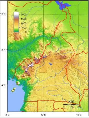
Figure 2. Topography of Cameroon. The Western Highland region represents the land above 1000 m elevation in white, purple and dark brown colouring. Source: Wikipedia.
GEF 6 Cameroon Integrated Landscape Management PIF 6
"Sacred Forests" have so far benefited from the protection of customary law, but are severely threatened by population pressure (PAN/LCD, 2006).
9. Ecosystem degradation has taken a heavy toll in much of the WHC, and yet the region is still home to globally significant biodiversity. The Bamenda Highlands are representative. They were once covered largely with montane forest, but today hold only fragmented patches of natural forest distributed across remote hill tops and steep slopes. The loss has been great: in 1958, 37% of the North-West region was forested; in just over 40 years, by 2000, this forest cover had been reduced to 3.5%. Today, less than 10,000 ha of mountain forest survives in the whole of the Bamenda Highlands region. But such island refuges are, however, recognized as critical habitat for endemic birds, animals and plants found nowhere else in the world. For example, 15 of 28 montane birds’ species endemic to Cameroon have been recorded in the Bamenda highlands, of which two are globally threatened. About 40 species of plants endemic to Cameroon have also been recorded here, as well as six species of mammals.
Meanwhile, the Oku-Ijim mountain forest (approx. 20,000 ha) constitutes the most important afro-montane forest in West Africa. In other words, while most remaining forest sites in the WHC are small and fragmented, they are nonetheless large enough to provide habitat for viable populations of species of many taxa, especially insects, plants, reptiles and amphibians, small mammals and many bird species. (Some plants are known to be confined to just one or two localities on mountain tops in the North-West, for example, and some amphibians are confined to a single lake such as Lake Oku.) Furthermore, beyond their present conservation value, there is potential for protected remnants to serve as nuclei for landscape-scale restoration (BHFP, 2000).
10. The WHC consists of the most heavily populated regions in Cameroon. Demographic pressure exerted on a limited land area has led to intensive crop cultivation on an estimated 95% of arable land in some parts of the WHC, including marginal sloping areas. A high population growth rate over the past 35 years has exacerbated the situation (Nkembi, 2012). The annual population growth, estimated at 3.5%, is a major driver of land cover change as more forest is converted for agricultural use, typically with poor yields. Reduced farm productivity has in turn spurred further conversion of remaining natural forest areas in search of more fertile soils. This cycle has caused widespread soil erosion, resulting in landslides among other negative consequences. Underlying this cycle is a lack of integrated, participatory land-use planning and management, coupled with continuing tenure insecurity and deepening social and economic conflict over land use alternatives.
11. The Bamenda Highlands landscape is again representative. This area is one of the most densely populated parts of Cameroon, with over 300 people per km2 in some parts, and an annual population growth rate of 3.2%. Pressure for land has resulted in the near disappearance of traditional long-fallow shifting cultivation systems, which in the past were largely sustainable. Since 1988, moreover, with the collapse of the Arabica coffee production in the area due to the fall of international coffee prices, which had been a major economic activity for many families, poverty levels of many rural farmers have increased. This has led to further environmental degradation as marginal farming and grazing strategies are expanded at the expense of remaining forests. While government investments have aimed to improve the agricultural potential of the region, population growth has resulted in a reduction in long-fallow swidden, and cultivation on ever steeper slopes. Most farmers do not engage sustainable practices to improve productivity and secure soil and water conservation (e.g. agroforestry techniques, animal and green manure). A continuing lack of secure tenure based on integrated, participatory land use planning at a landscape scale undermines the capacity of actors at multiple scales to reverse the cycles of degradation that have taken hold.
Increased forest degradation and deforestation:
12. In the South, commercial agricultural expansion, particularly related to cocoa and rubber production, as well as oil palm, is the main driver of deforestation. While still limited in comparison to other global flashpoints for commercial plantation development (e.g. Indonesia, Liberia), in the near future, increasing global demand for these cash crops is likely to accelerate deforestation. Meanwhile, intensive industrial logging, as well as informal and illegal logging, drive forest ecosystem degradation, including biodiversity loss. Poor and unsustainable logging practices (e.g. high-grading operations and extraction that does not plan for or ensure adequate regeneration), while not typically leading to outright deforestation, often degrade forest stands and reduce biodiversity values. Regardless of ecosystem type or silvocultural regime (or the lack thereof), the key impacts on biodiversity from timber harvesting operations are mostly secondary, including most notably: increased use of flora and fauna as a result of the opening of previously inaccessible areas; increased forest conversion due to greater accessibility;
and negative effects on soil and water from road construction, felling, skidding, landing operations and stream crossings.
Additionally, overharvesting of a small number of commercial timber species may undermine the genetic integrity of target species populations, while altering stand structure, growth and micro-site dynamics. In general, weak capacity to enforce forestry regulations and implement SFM means that significant and widespread irregularities are encountered in existing logging concessions. More than any other country in the region, Cameroon has promoted community forestry as a way to increase benefits to local people and maximize participation in sustainable management. But in spite of 20 years of development, key barriers remain in order to fully realize the potential of community-based natural resource management (CBNRM).
GEF 6 Cameroon Integrated Landscape Management PIF 7
13. While illegal and unsustainable timber harvesting practices lead to forest degradation in the South region, deforestation in the tropical forests of Cameroon is caused by two major trends: the clearing of land for rubber and oil palm plantations in concessions granted by the state, and the clearing of forests on small surfaces but on a large scale for agriculture in general and cocoa in particular. In the context of smallholders – the end beneficiaries of this project, the main threat to the forest is the demand for new farmland. Cocoa farmers, for example, had an average daily per capita income in 2011 of 1.72 USD with a large number of farmers and their families living in poverty. Apart from the need to expand their productive lands, local communities depend on biodiversity resources to sustain livelihoods such as non-timber forest products and game. The pressure on biodiversity as a result of poverty is discernible. About 40% of the population in Cameroon are classified as poor. In a vicious circle, the poor depend on biological resources for their livelihoods. Where poverty is generalized, the issue of food
insecurity becomes apparent with the poor relying on overharvesting of biodiversity resources and poaching, to sustain their livelihoods. It is clear that natural ecosystems are becoming degraded in target sites where indigenous peoples and other local communities live.
14. While still limited in comparison to other global flashpoints for commercial plantation development (e.g. Indonesia, Liberia), in the near future, increasing global demand for cash crops is likely to accelerate deforestation. Cameroon’s National Biodiversity Strategy and Action Plan (2012) highlights that the increasing demand for land over thousands of hectares for oil palm, rubber, coffee, cocoa, and tea plantations call for the clearing of vast expanse of vegetation and change local biodiversity balances with the risk of eliminating certain fauna and flora while at the same time introducing invasive species of predators. It is estimated that between 1990 and 2010, Cameroon lost 18.1% of forest cover at an average rate of 0.90% annually (thereddesk.org, 2016).
15. In all of the North, Adamawa, West and North-West regions, the conflicts related to land use have been considered as an important issue which affects sustainable natural resources management. The analysis conducted in the process of the National Action Plan to Combat Desertification alignment to UNCCD 10 Years Strategy (2014), indicated the absence of the operationalization of land use management schemes and the lack of law or enforcement of law related to landscape management. Furthermore, the current natural resources management practices are not sustainable and contribute to the increase of natural resources and land degradations. Improvement of soil fertility appears to be an important factor particularly in the North, North-West and West regions. The specific objective 1.1 of the revised NAP is therefore to “ameliorate the co- management conditions of the landscape by various users and stakeholders” (Aligned NAP 2014 – 2018).
The main barriers to be overcome in achieving the project objective are:
Absence of legal framework in favor of local and traditional forest conservation measures:
16. From a forestry and biodiversity perspective, there is an equally limited legal framework to codify and formalize CBNRM protection measures. Despite the cultural and conservation importance of Sacred Forests in the WHC, forest regulations do not specifically recognize this class of forest, which is coming under increased threat. While traditional measures to control access and combat conversion are a critical basis for a conservation strategy, the lack of legal status for Sacred Forests has limited the financial resources available for HCVF/KBA conservation. Such remnant forests are thus subject to degradation and continued loss of area, reducing biodiversity and ecosystem services in a region where such remaining natural forest collectively play a critical role in present and future efforts to secure CBNRM and sustainability. Beyond these islands of HCVF/KBA, the overall
Figure 3. Land-cover changes in South Cameroon between 1968 and 1993. The map shows the significant expansion of agroforests – a trend that continues to date. Source:
ASB Technical Report, 1997. Map based on remote sensing.
GEF 6 Cameroon Integrated Landscape Management PIF 8
capacity of local actors and producers to engage best management practices in multiple sectors – livestock, subsistence farming, commodity production, and ecosystem restoration – hinders the long-range prospects for landscape restoration and sustainability. There is, moreover, a paucity of inter-institutional coordination at multiple scales needed to facilitate cross-sector collaboration and enable integrated landscape-scale planning and implementation of best practices.
17. In the South, while the legal framework has generally been supportive of greater CBNRM through community forestry concessions – the 1994 Forestry Law allowing for community forestry put Cameroon far ahead of other countries in the region – a continuing lack of capacity at multiple scales undermines the model’s ability to secure sustainability in the region. In the forest, a majority of communities lack the technical capacity to undertake sustainable forest planning and harvesting operations, placing the forest at risk of stand and species degradation, as well as the negative potential effects from poor logging practices on soils, water and wildlife. On the enterprise side, weak organizational and business administration capacity hinder the ability for community forests to maximize the benefits of forest harvesting and ensure an equitable distribution of those benefits. Such limited capacities are compounded by a complicated and expensive regulatory regime, which acts as a disincentive to legal, sustainable forestry.
Weak market and regulatory incentives for sustainable products:
18. At the national level, demand for legal or certified timber and other forest products from sustainably managed forests is highly limited, making it difficult to position wood from sustainably managed community forests in preferred markets. Despite the increasingly public commitment of Central African countries to sustainable forest management and legality (e.g.
FLEGT/VPA processes), there are no public policies or procurement requirements regarding the origins of purchased wood.
Although some regional initiatives in the community forestry sector (e.g. funded by the Congo Basin Forest Fund, DFID and the European Union) have made progress, there are few market-based initiatives to incentivize the development of community forest enterprises that can secure economic and social sustainability.
19. Outside the forestry sector, while there is increasing demand for certified internationally-traded commodities (e.g. cocoa, coffee, tea), demand in domestic markets for such products remains weak. To the extent that this project will work in agricultural value chains as part of a landscape-scale approach in the WHC and in the South, investigations during the PPG phase will define target landscapes and value chains, and will identify opportunities for marketing sustainable products in local, regional and international markets.
Lack of integrated, participatory land-use planning and management, coupled with continuing tenure insecurity and deepening social and economic conflict over land use alternatives:
20. In Cameroon, Decree No. 74-1 (1974) is the basis for land use planning and the issuance of legal titles. Decree No. 678 (1995) sought to simplify a highly complicated and bureaucratic process, clarifying the rules for land use zoning and complementary mapping of planned development. However, to date and in general, land use planning has not been undertaken in a systematic, participatory or integrated manner. Implementation of official land legislation has been hindered as it often contradicts with traditional land rights. Moreover, since communities and individuals are not required by law to title their land prior to usage, there is a continuing inertia around organizing to undertaking planning and titling. Ordinance-Law 94-1 establishes that people may “continue effectively and peacefully occupying” the land without a title. Individuals may also continue hunting and fishing on “vacant land” as long as it does not conflict with other uses by the State (Art. 17 of Ordinance- Law 74-1). Given the highly expensive, time-consuming and conflictive process, it is thus no surprise that titling has been largely limited to urban areas; formal legal tenure remains insecure in most of rural Cameroon. The legal exemption to occupy
“vacant land” without title – while laudable in that it does not illegalize rural livelihoods – acts as a disincentive to engage formalized land-use planning. Most land is still held under customary tenure arrangements and administered by traditional rulers. As more land is acquired by the government, influential urban elites, powerful agro-industrial companies, and traditional leaders, customary tenure systems no longer provide people with security over their land (Javelle, 2013). The continuing lack of integrated, participatory land-use planning, meanwhile, undermines CBNRM efforts in increasingly marginal landscapes like the WHC under heavy pressure and social conflict.
Weak capacity of civil society organizations to support the implementation of alternative production systems and access resources
21. Producer’s limited access to finance to capitalize both preparation and harvest operations, as well as investments in value- added processing, conspire to act as major barriers to the development of competitive community-based enterprises. Funds used by communities to finance income-generating forestry and agricultural activities are typically produced by informal financial systems which can only provide very small amounts, or through external buyers who fix the prices and conditions in their favor.
In forestry, for example, buyer advances for working capital often land community operations in a debt cycle that is difficult to escape. Finally, across the country, there is weak capacity among civil society organizations (CSOs) and local non-government organizations (NGOs) to assist processes of CBNRM planning and management. Lessons from decades of donor assistance
GEF 6 Cameroon Integrated Landscape Management PIF 9
point to the critical role of such groups to ensure continuity and sustainability of locally-based solutions for conservation and development. Furthermore, NGO technical capacity to work hand-in-hand with local communities implementing CBNRM remains a challenge.
b. The baseline scenario or any associated baseline projects
22. In the WHC, a range of agricultural and rural development projects have been implemented since the 1970s. In general, there has been little focus on forest and biodiversity conservation issues in these projects, even less on undertaking integrated, participatory land use planning at a landscape scale to achieve sustainability. During 2004-2007, the government, with support from the African Development Bank, supported PAFRA (Rural Forestry and Agro-Forestry Support Project) to undertake large- scale reforestation in the Haut Plateau and Bamboutos Departments. While undertaking planting on close to 3,000 ha and establishing tree nurseries, the project’s sustainability has been called into question due to the focus on eucalyptus, a species known to have failed to achieve desirable results for restoration in other parts of the world.
23. Since 2003, a range of interventions led by MINFOF and a number of national NGOs (e.g. Knowledge for All, ACREST and ERuDeF) have been implemented, attempting to conserve biodiversity and ecosystems around Mt Bamboutos. ACREST, with funding from IUCN, is supporting a small scale reforestation scheme on a section of the mountain in the Bamboutos Division. With additional funding from Co2balance, the NGO is promoting sustainable fuelwood consumption with improved cook stoves. With the support of the World Bank Cameroon Marketplace program, ACREST has also trained and established a network of producers of biochar in three villages in the areas around Mt Bamboutos. On the Lebialem side of the mountain, ERuDeF, with small-scale funding from GEF’s Small Grants Program is executing a pilot program on the implementation of the Access and Benefit Sharing (ABS) Initiative in Cameroon under the auspices of the MINEPDED. Another intervention was the the GEF project "Community Based Conservation in the Bamenda Highlands" (1999), which responded to the main forces driving forest loss which were: (i) inadequate management and control of forest resources, due to breakdown of traditional institutions and inadequate implementation of government mechanisms for forest protection and management; (ii) inability of communities to manage natural resources sustainably, caused by pressure of population, lack of awareness of forest values, lack of (economic) incentives for sustainable forest management and lack of capacity for alternatives to forest clearance; and (iii) critical biodiversity areas are not being protected due to an incomplete and incoherent protected area network, incomplete information on biodiversity and its distribution, and lack of capacity for PA management. Taking an ecosystem approach to conservation of Bamenda Highland montane forests, the project has scaled-up the pilot Kilum-Ijim Forest Project (KIFP), provided support to communities (working with 51 different communities), built capacity in a former MINEF Technical Operations Unit (TOU), and also expanded support for forest management to at least 8 other forests and their communities. The objective of the programme was to support the efforts of the GOC and people of North West Region to conserve the forest by:
raising widespread awareness of forest values; supporting development of management and control systems for sustainable management of forests (capacity building); and providing communities with the capacity to manage resources sustainably (by demonstrating ways of enhancing forest values, and providing advice on ways of sustainably increasing production from land outside the forests). The lessons learn from this project will be carefuly assessed during PPG and promising products will be considered for application including adapting it to the new GEF project context.
24. Small scale but highly relevant interventions in the North-West region include those of the World Agroforestry Center (ICRAF) and the International Circle for the Promotion of Creation (CIPCRE) that supported farmers’ incomes diversification through fruit tree domestication, while encouraging the development of sustainable agroforestry practices. While ICRAF has recently terminated its operations in that region, ERuDeF is currently increasing its scale of operations with funding from the US non-profit organization Trees for the Future. Furthermore, the local branch of MINFOF in the North-West is leading efforts to create the first national park in the region.
25. In the North-West region, moreover, during the 20 year period between the 1980s and the mid-2000s, a number of international organizations (e.g. Birdlife International, Helvetas, and Deutscher Entwicklungsdienst (DED)) have promoted biodiversity conservation. Birdlife, for instance, ran a program for the biodiversity management of the Kilum-Ijim forest for over 10 years that led to the protection of 20,000 ha and the creation of the Plant life Sanctuary in the Mt Oku area, alongside a group of community forests. Kilum-Ijim is the largest remaining afro-montane refuge in West and Central Africa, and adjoins Lake Oku, with abundant, threatened and endemic aquatic wildlife. Alongside these efforts, Birdlife also supported a region- wide program on community forestry development with a strong involvement of local civil society groups. In 2003, the project was handed over to the MINEF (which later on split into MINEPDED and MINFOF) and the related local institutions. With the departure of Birdlife, Kilum-Ijim protected area has received no effective funding to support its management since its creation.
Attempts were made by a small number of CSOs to create community forests in the West region within the framework of the Western Highlands Nature Conservation Network (WHINCONET). These communities were meant to play an increasing role in protecting and conserving biodiversity, as well working on sustainable livelihoods through income from activities such as harvesting of non-timber forest products (e.g. Prunus africana bark, bamboo, cola nuts, honey and Eru), as well as hunting,
GEF 6 Cameroon Integrated Landscape Management PIF 10
timber and fuel wood (WHINCONET, 2007). These attempts however quickly ended as the CSOs never had adequate funding with the departure of Birdlife in the mid-2000s.
26. A project conducted in 2011 by the NGO Millennium Ecologic Museum and funded by CARPE, the Central Africa Regional Program for the Environment, has produced an inventory and cartography of Sacred Forests in Cameroon. Based on sample data, it estimates that Cameroon counts 1,361 Sacred Forests, covering about 47,000 ha. The study also evaluates the conservation system rooted in traditional beliefs and practices, identifies the major challenges they face and recommends priority areas of intervention for a national strategy for the conservation and recovery of Sacred Forests.
27. In the West region, the study identified 310 Sacred Forests (see Fiure 4). The largest areas were observed in the Departments of Kung-chi and Highlands. The forests are usually forest relics and forest galleries, at times enriched with eucalyptus. Their surface area ranges of 0.1 to 91 ha with an estimated total surface area of 1,323 ha. 36% of those forests are said to be at risk of degradation.
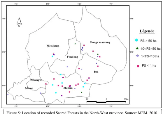
28. In the North-West region, Sacred Forests are significantly larger in size reaching up to 3,000 ha for the largest ones, with a total surface area estimated at 42,668 ha (see Figure 5). The total surface area has been calculated based on 30 out of 204 fondoms surveyed. The largest forested areas were observed in the Mezam and the Ngo-Ketunjia Department. Forests are largely Eucalyptus plantations, remains of dense Afromontane forests, gallery, swamp, montane, and relics of submontane forests. Here, 57% of forests have been evaluated to be at risk of degradation.
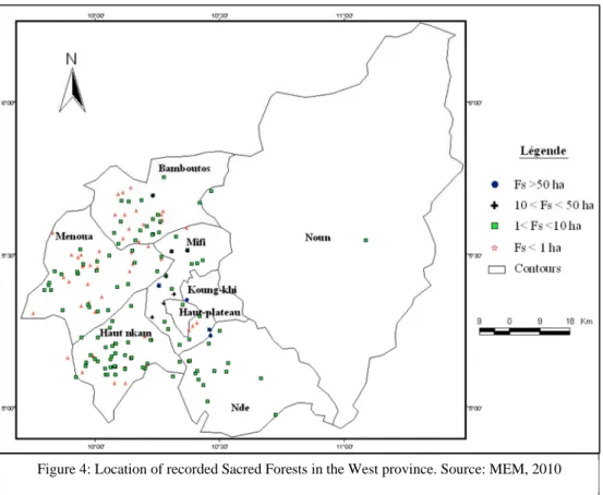
29. In the South region, Rainforest Alliance with funding from the Congo Basin Forest Fund implemented a project between 2010 and 2015, whose objective was to support twelve forest communities around the Campo-Ma’an National Park and the Dja Biosphere Reserve to develop sustainable management plans, increase capacity for forest harvesting, build local organizational and entrepreneurial capacity, and access markets. While much has been achieved, communities need more support to transform their burgeoning activities into viable, competitive enterprises that will deliver on the range of benefits responsible production can provide, including access to premium international markets. Communities need to ensure the equitable use of benefits from forest products sales, including improved wages for workers, the development of social projects, and reinvestment in forest enterprise. Activities foreseen by this project in the South region will be co-financed by Rainforest Alliance, while capitalizing on achievements to date to develop another example of community-based natural resource management in a representative context of lowland tropical rainforests.
Figure 4: Location of recorded Sacred Forests in the West province. Source: MEM, 2010
GEF 6 Cameroon Integrated Landscape Management PIF 11
30. Several lessons and recommendations emerge as clear from this history of past and present efforts. First is that restoration and agricultural development schemes in the WHC must proceed from a participatory, landscape perspective and integrate multiple sectors based on a CBNRM approach for long-term success. Second is that conservation projects must be connected to wider plans for land management and be tied to long-term financial support. Third is that efforts to establish community forests must also include an enterprise and market development component to ensure that such operations are able to sustain themselves once external support is unavailable. Fourth is that for sustainability to be secured, local CSOs must be strengthened to carry forward work with community partners.
31. Further, the World Bank-GEF project "Sustainable Agro-Pastoral and Land Management Promotion under the PNDP"
generated a number of lessons that can help to inform the design of subsequent operations in Cameroon and elsewhere. The project focused on enabling communities to contribute to combating land degradation in critical areas, through the adoption of best SLM practices and the development of adequate capacity, tools and mechanisms by communities. The Project built on national sustainable land management programs to ensure that the short and medium-term objectives of increased land productivity and agricultural growth are reconciled with the long-term local, national, provincial, and global environmental objectives. The Global Environmental Objective (GEO) was to enhance the sustainable land and natural resource management by complementing the local and national benefits of SLM with key global benefits such as: (i) conservation of globally significant above and below ground biodiversity; (ii) reduction of carbon emissions via improved land management activities, rehabilitated degraded lands and increased carbon sequestration; and (iii) stabilization of riparian zones and reduction of sediment discharge into critical transboundary water bodies such as Lake Chad and the Gulf of Guinea. As main results of the project, the vegetative cover was increased at 185%; the indigenous knowledge of communities has been successfully integrated into the SLM practices in Center, West, North and Adamaoua regions, with a rate of adoption of agro-pastoral systems increased from 65% to 80 % in the North/Adamaoua regions; a total of 402 community-based organizations have gained improved knowledge of SLM and environmental issues and are able to properly implement biodiversity and environmentally- friendly SLM practices; 21 conflict resolution frameworks have been revitalized and are effectively operational at the communal level, through land tenure and land-use conflict litigation commissions. Lessons learnt include (1) the initial land use and management plans prepared under this Project have demonstrated that land use and management planning is a very powerful tool that can be used to produce consensus and limit conflicts among land users. It seems important to further institutionalize this tool to all municipalities in the country. (2) Local communities will benefit most from SLM practices when they have reliable access to markets for their products. A rapid market appraisal revealed that a significant proportion (60 percent) of the crops and livestock products produced by beneficiaries is sold to a group of intermediaries who act in concert to manipulate product prices. (3) The introduction of SLM technologies needs to be accompanied by investments in complementary infrastructure, such as storage facilities for cereals, physical market places, and access roads. (4) Measures to ensure the sustainability of SLM micro-projects need to be included in the Project design. Institutional capacity needs to be developed, for example through the creation of farmer organizations, marketing cooperatives, and trade associations. (5) Gender
Figure 5: Location of recorded Sacred Forests in the North-West province. Source: MEM, 2010
GEF 6 Cameroon Integrated Landscape Management PIF 12
considerations needs to be taken into account when selecting SLM technology. In some municipality, lack of knowledge of the division of labor between men and women led to unequal rates of participation. In this municipality, where women are predominantly involved in production of staple crops and poultry farming, the choice of raising pigs as a means of producing compost discouraged participation by women.
32. The above mentioned progress, tools and results which will support the project foundation, some baseline projects of particular relevance are currently under implementation in the project areas. These include:
i) The Program for the Improvement of Competitiveness of Family Agro-pastoral Farms (ACEFA) is implemented in all ten regions of Cameroon, under the leadership of the Ministry of Agriculture and Rural Development (MINADER) between 2013 and 2017. The project’s objective is to improve the economic performance of agropastoral commodities and increase the revenues of farmers. This program will benefit from the sustainable land management and sustainable forest management technologies that will be developed by the project. ACEFA will provide financial support to farmers to test the technologies and scale them. With an overall budget of $101M, part of the Program’s financing will serve as co-finacing to the GEF project.
ii) The project “Grassfield, Rural Infrastructure and Participatory Development Support Project” by the North West Development Authority of Cameroon (MIDENO) is currently in its Phase II, which runs from 2013 to 2018 with a budget of $39M. It is implemented in the North-West region under the Ministry of Agriculture and Rural Development of Cameroon (MINADER). The project’s objective is to improve agricultural production and income of beneficiary communities by creating rural infrastructure and building the actors’ capacity. Activities taking place during the lifetime of the GEF project will serve as co-financing.
iii) The project “Inventory, Mapping and Diagnostic Study of Sacred Forests in Cameroon: Contribution to Develop a National Sustainable Management Strategy” implemented by the NGO Millennium Ecologic Museum and funded by CARPE in 2011. The study’s objective was to make an inventory and cartography of Sacred Forests in Cameroon, understand the logic of ther creation and the perceptions of local communities in order to sensitise the public administration on the necessity of their conservation and their inclusion in the forest policy and programs for the conservation of biodiversity.
iv) In Cameroon, UNEP-GRASP supports the WWF for the development of a methodology to determine High Conservation Values at national and concession levels. Identifiying HCVs is a key requirements of major certification schemes such as the Forest Stewardship Council (FSC) or the Roundtable on Sustainable Palm Oil (RSPO), but the indicators and criteria for the identification of HCVs vary greatly from country to country, making it difficult for companies seeking certification to prepare strong HCV assessments that withstand public scrutiny. Upon request from the Ministry of Environment, UNEP-GRASP and WWF are supporting the development of a national HCV methodology through a wide consultative process led by a firm accredited by the HCV resources network, that will provide the necessary tools for the Government to assess their HCV areas at national level to inform development plans, and provide the tools required for companies to develop strong HCV assessments in their concession in the specific context of Cameroon. The methodology is seen as a key step in preparing the ground for certification and encouraging certification, and helping the Government with decision-making tools for land-use planning
c. The proposed GEF alternative scenario, with a brief description of expected outcomes and components of the project
33. With the support of GEF, the proposed project will build from the above baseline scenario to address deforestation, and forest and land degradation through the promotion of integrated, participatory landscape-scale CBNRM. The focus of activities will be in demonstration sites in the WHC and to a lesser extent in the South of Cameroon. Field interventions will center around participatory land-use planning, protection of HCVF/KBA, sustainable land management in non-forested areas, and the establishment and growth of community forestry and local enterprise, supported by effective policies and links to sustainable markets. Importance will be attached to a participatory approach, involving women, young people, traditional authorities and their networks, and the regional and local councils. Equally important is the integrated nature of planning and coordination with a multi-sectoral participation of institutions. A strong focus on CSO engagement through project interventions and support to local NGO capacity building will secure the sustainability of the GEF investment beyond the life of the project. Moreover, strengthening of institutional knowledge and sharing of tools and lessons learned through project work in two differentiated and representative contexts, will ensure that the project has impact across the region and informs allied efforts.
34. Global evidence is mounting that CBNRM can outperform strict protected areas in maintaining forest cover, while providing economic development opportunities for marginalized groups. Traditional and community managed lands have shown to provide enhanced opportunities for the improvement and maintenance of carbon stocks and the conservation of
GEF 6 Cameroon Integrated Landscape Management PIF 13
biodiversity, as well as providing livelihood opportunities for rural communities. A study of tropical forest governance models produced by World Resources Institute and Rights & Resources Initiative in 2014, for example, shows that deforestation is reduced where communities have management rights and are given adequate external support. In the Maya Biosphere Reserve of Guatemala, where Rainforest Alliance has been supporting community forests for 15 years, a recent analysis showed that community forests had deforestation rates close to zero, whereas adjacent protected areas experienced forest conversion above regional averages11. While in Cameroon the approach is still in its nascent stages, there is significant scope to build out the model for conservation and economic development. The present effort will help to do so, piloting CBNRM approaches in the varied contexts of the WHC and the South of Cameroon.
35. The specific objective of the project is to enable improved biodiversity conservation, land restoration, and sustainable landscape and forest management through participatory, community-based natural resource management (CBNRM) and local enterprise development.
36. The project will focus field activities in the montane North-West and West regions of the Western Highlands of Cameroon (WHC), as well as to a lesser extent in the South region, which is home to lowland tropical forest. These two regions of the country are sharply differentiated – one a highland region that is heavily populated and experiencing continuing processes of land degradation, and the other a sparsely-populated lowland expanse largely covered with closed canopy natural forest which, until recently, has been under relatively limited threat of conversion.
This objective will be achieved through implementing a series of activities (to be defined in detail during the PPG) under the following components/outcomes:
Component 1: Community forest protection and institutional alignment for integrated landscape management
37. A critical anchor for such efforts in the WHC are remnant HCVF/KBAs. In many cases, their survival owes to the efforts of traditional cultures that protect such areas as Sacred Forest. In many of the villages of the WHC, Sacred Forests are the only remaining natural forests. Such areas are commonly defined as plots of natural forest found in villages, and which serve variable traditional, cultural, economic and ecological purposes. Tied to these Sacred Forests are the adjacent traditional palaces (fondoms) that also constitute centers of cultural tourism that could be developed to their full touristic potential. It is estimated that Cameroon counts 1,361 Sacred Forests located in six of the country’s regions (West, North-West, South-West, Adamawa, North and Far-North), covering about 47,000 ha. 94% of this area is found in the West and North-West regions (MEM, 2010).
Sacred Forests are headed by the paramount chiefs, the Fons, who are highly respected and play an important role in the governance of the region. Traditionally, the Fons are custodians of the forest and can allocate it for farmland. This responsibility was eroded over the years as land pressure increased and rights were taken over by central government. The vast majority of Sacred Forests are protection-oriented areas. A few cases of socio-economic value generation, however, exist through activities such as ecotourism, e.g. in Fongo Tongo and Oku in the North-West. Sacred Forests are not only of high socio-cultural importance, but they are also rich in endemic and globally significant biodiversity species. Moreover, they are of high ethnobotanical importance given the strong influence and interactions between humans and the forest. Despite these critical socio-cultural and environmental values, about 56% of the Sacred Forests in the WHC are considered to be at risk of degradation (MEM, 2010). The main drivers of degradation are agricultural expansion, conflicts between villages, weakening of traditional beliefs, bush fires, livestock pressures, and uncontrolled collection of fuelwood. Underlying these drivers are root causes including high population density, weak tenure security, poor governance and a lack of integrated, participatory land use planning at a landscape scale. The PPG phase will define the priority landscapes to focus on, based on an identification of HCVFs in KBAs (as described and illustrated in Annexes 2-4) with the highest priority for conservation, which may be used as
“anchors” around which to conduct landscape-scale participatory CBNRM planning. Other selection criteria will include the surface area of the Sacred Forest, closeness to other sacred forests and other forest complexes (in order to maintain/establish connectivity and resilience in forest conservation) and the identification of landscapes with the highest potential to achieve targeted impact as defined in the project’s theory of change.
38. GEF funds will support improved conservation of Sacred Forests in the WHC, specifically through the codification and formal recognition of Sacred Forests as High Conservation Value Forests (HCVF). Sacred Forests Codified laws refer to rules and regulations that have been collected, restated, and written down for the purpose of providing civil order to a society on Sacred Forest. In Cameroon, revisions to forestry law have enabled community associations and cooperatives to acquire the exclusive rights to manage and exploit up to 5,000 ha of customary forest, under a 15-year contract. According to study on
“Impacts of land-use change on sacred forests at the landscape scale” published in Global Ecology and Conservation in January 205, past changes in area and patch fragmentation of land cover classes and individual forest patches in the Gamo Highlands, Ethiopia, were assessed using maximum-likelihood classification of LANDSAT images. While all four individually studied
11 http://www.rainforest-alliance.org/publications/deforestation-trends-maya-biosphere-reserve
GEF 6 Cameroon Integrated Landscape Management PIF 14
non-sacred forests decreased in size over a given only four of the six individual sacred forests patches showed reduction in area.
Forest patches with sacred status had greater protection by local communities than non-sacred forests in the Gamo Highlands. In line with efforts under Component 2 below, landscape-scale participatory land-use and CBNRM planning will also identify other important forest areas (e.g. riparian zones, forest on steep slopes, community forests, areas in need of restoration, as well as forest reserves) in the WHC for integration with both regulatory efforts and SLM interventions. The GEF investment will be targeted towards improving the protection status of 4,000 ha of HCVFs contained within the KBAs of Northwest and West Regions. These KBAs are Mount Oku, Mbi Crater Faunal Reserve-Mbingo Forest, Njinsing-Tabenken, Bali-Ngemba Forest Reserve, Mount Lefo, Mount Mbam, Bamboutos Mountains and Mont Bana as illustrated and described in Annexes 2-4. While official recognition of HCVF/KBA protection is a critical element to anchor landscape-scale efforts, the work of participatory, integrated land-use planning and management will require inter-institutional cooperation to enable cross-sector collaboration between actors at multiple scales. The project will thus establish landscape management boards – including differentiated representatives of the traditional authorities, village and local councils – to facilitate and monitor land-use planning (component 2) and follow-on interventions (component 3). In order to address its sustainability and in line with the decentralization process in Cameroon, the project will build on existing inter-institutional platforms at the commune level to support consideration of Community Based Natural Resources Management in these platforms. GEF funds will support stakeholders consultation which will lead to the consideration of CBNRM by the platforms. Different existing platforms exist at local level: (i) Decree of 3rd September 1978 require each district level to establish consultative bodies to manage conflict between farmers and pastoralists.
In application of this degree, the Head of District has established in each municipality consultative frameworks chaired by the Head of District and which mandate is limited to the district; (ii) In the project area, at the level of municipality consultative frameworks exist which include different sectors (agriculture, livestock, forests, environment, representatives of livestock private sector and representatives of farmers organizations). These frameworks are in charge of the development and monitoring of communal development plans which give due consideration to natural resources management. This is supervised by the Participative National Development Programme under the Ministry of Economy, Planning and Landscape Management; (ii) Under the programme of debt Swap (C2D) with the French Government, there is currently a REDD+ project which is about to be completed of which one of the key outputs is the establishment of intercommunal conflict management frameworks and which deal with natural resource management around the reserve of Bana-Bangou-Bangangte (500,000 ha surface area); (iv) It is good to note that in each municipality in Bangante there is a plan in their staff organigram to establish a environment focal point position. In other communes like Coutabe an entire office has been established to deal with environmental management issues. During PPG, the various local frameworks will be evaluated and the most suitable recommended to be capacitated to form the landscape management board. A sustainable funding mechanism of the contnous operation of the platform will be discussed and agreed upon by all stakeholders. One of this mechanism may be through budget line created within national support to the decentralization process. At the same time, legal and technical frameworks for official recognition of such bodies and landscape management plans will be generated, based on analyses of existing regulatory tools and gaps. Finally, work will be undertaken to address legal and regulatory barriers and mobilize policy incentives to support the development of local enterprises based on CBNRM.
Outcome 1.1. Improved protection status for 4,000 ha of High Conservation Value Forest/Key Biodiversity Area (HCVF/KBA) managed by communities (i.e. Sacred Forest) in the Western Highlands of Cameroon (WHC), and clear cross-sector coordination mechanisms for integrated landscape management
Output 1.1.1 Legal and technical frameworks for attributing conservation status to identified HCVF/KBA managed by communities in the WHC developed based on stakeholder consultations and submit to designated authorities and approved
Output 1.1.2 Existing Inter-institutional landscape management bodies strenghen in two priority landscapes in WHC involving multi-sector and multi-scale stakeholder groups
Output 1.1.3 Frameworks to institutionalize participatory sustainable landscape management are developed, including mechanisms to incentivize local CBNRM enterprise submitted to designated authorities and approved
Component 2: Development of capacity and incentives to support HCVF/KBA management and SLM and SFM deployment 39. With baseline information collected and analyzed, the project will work through the proposed landscape management board to articulate landscape management plans outlining theories of change, zoning areas for different uses and monitoring strategies.
Specifically, these plans will promote adoption of best SLM and SFM practices that are based on recognized international standards and are adapted to the local context, field tested with key stakeholders, thus aligned with the CBNRM approach. Such measures will be introduced to stop degradation in forests, begin the process of landscape restoration, and build linkages to sustainable markets for identified crops with potential for development. The landscapes in WHC will anchored around the sacred forests/ HCVF/KBA identified under Component 1. In addition to the Sacred Forests of the WHC covered in component
GEF 6 Cameroon Integrated Landscape Management PIF 15
1, the project will work in an agroforestry landscape that includes community forests and agricultural uses in the South region.
In a similar way to the two priority landscapes in WHC, the landscape in the South will be chosen based on criteria to be defined during PPG. However, the HCVFs targeted by the project (4,000 ha in HWC, and 21,000 ha in the South Region) will form part of the KBAs as described and illustrated in Annexes 2 – 4.
40. The project will take a multi-sector approach, bringing all economic interests together to manage the landscape, rather than only one specific commodity sector. To enable SLM and SFM to take root, organization at producer group and community level will be essential. As knowledge and technical information are critical elements for the development of smallholder productive systems, the project will establish or strengthen capacity building activities to promote appropriate technologies for sustainable intensification and agroforestry practices with the objective of reducing pressure on biodiversity. In order to address the barrier of weak organizational capacity in communities, the project will provide technical assistance and support in order for communities to form CSOs that are focused on the production and marketing of sustainable produced products (both agricultural and NTFPs) and capacitate such CSOs. The training curriculum of the CSOs to be developed and used in the training of the CSOs (and farmers) will have a strong business administration component to ensure that these CSOs are run as efficient and effective businesses and best serve their constituency. Further, the capacity building of the CSOs will incorporate an Enterprise and Market Development Component, to assist the proponents in identifying viable products and market it in such a way to ensure eventual profit. The project will initially focus and assist the proponents in existing products and grow the markets, but will also during the project expand depending on market indications and needs. Existing products include, but will be further defined during PPG, small livestock (poultry, goats), bean cultivation and corn, vegetables, bee keeping, bush mango harvesting, raffia palm, Njangsan12 and medicinal plant products e.g. Bitter kola13 production. The demand in local markets of raffia wine, use of tree bark to prevent and treat disease and the commercialization of certain food products like Eru14 has increased the exploitation of some NTFPs, e.g. raffia palm and medicinal plants collected in the forests. These businesses and their contributions to family incomes have increased the number of producers and commercial intermediaries who derive significant income from the emergence of ‘raffia wine, medicinal plants and wild food’ sectors. This is illustrated by the emergent economies around Mount Oku, in North-west Region of Cameroon. Agriculture and forest products operations have for long been the main activities around Mount Oku. With the abandonment of coffee production since the late 1980s, beekeeping appeared as an alternative to reduce rural poverty. It is estimated, based on data collected from producers in 2012, that 44,255 kg of honey was produced from this area (a KBA, refer to Annex 4), more than half of the honey produced in the whole of west and north-west regions of Cameroon. These estimates do not take into account domestic consumption. There has also been an increase in the value of land containing raffia palm due the market demand for raffia wine. A plot of 100 m2 which used to to be less than USD 70 in the 1980s is now sold for USD 800. The commercialization of raffia wine is also provided significant incomes throughout the value chain. The analysis of field data revealed that a salesperson can sell an average 100 litres/day with a gross margin of around USD 14 – 16 a day. With this core business, the salesperson earn a monthly income estimated at around USD 450 (USD 5400 a year). Thus, marketing of agricultural and NTFP products generate significant
12 The term Njangsan refers to an oily seeds tree, Ricinodendron heudelotii, found in tropical West Africa. It is a rain forest seed, picked on its stem, dark brown in color and very rich in vitamins. The seeds are usually dried and used as flavouring agent in West and Central African food dishes.
Known as Munguella (Angola), Essessang (Cameroon), Bofeko (DRC), Wama (Ghana), Okhuen (Nigeria), Kishongo (Uganda), Akpi (Cote d’Ivoire), Djansang, Essang, Ezezang and Njansang in several West African countries. The paste of the ground kernels is used to thicken soups and stews, for example pepper soup.
13Garcinia kola (bitter kila) is a species of flowering plant in the Clusiaceae or Guttiferae family. It is found in Benin, Cameroon, Democratic Republic of Congo, Ivory Coast, Gabon, Ghana, Liberia, Nigeria, Senegal and Sierra Leone. Its natural habitat is subtropical or tropical moist lowland forest. The fruit, seeds, nuts and bark of the plants have been used for centuries in folk medicine to treat ailments from coughs to fever.
Garcinia kola is traditionally used by African medicine men who believe that it has purgative antipa