No part of this publication may be reproduced in any way without full acknowledgment of the source. Deforestation: Clearing the site of shrub and undergrowth vegetation, but excluding tree stump removal.
INTRODUCTION
- DWAF Vision
- DWAF Mission
- DWAF Values
- Aims of the Environmental Best Practice Guidelines and Specifications
- Context of this document
- Scope of this document
- Application of this document
In addition to its function as a guide to environmental planning and design, this manual also contains an Environmental Code of Conduct, which is relevant to any person in any capacity who gains access to the site for a reason related to the planning of the project in question. A Master Plan also helps to provide clarity to the Implementing Agency, Stakeholders, Interested and Affected Parties and the Contractor as to the goals of the holistic planning.
ENVIRONMENTAL PLANNING GUIDELINES (GENERIC ENVIRONMENTS)
Biophysical environment
- Climate
- Geology
- Topography
- Surface hydrology
- Ground water
- Soil
- Flora
- Fauna
Promote the sustainable use and protection of native vegetation for food, medicine or other uses. Protect animal communities with recreational value (i.e. potential for fishing, hunting, bird watching, etc.) and use protected areas for environmental education.
Aesthetic environment
Allow for permanent wildlife movement corridors upstream and downstream of fordable structures such as dams and weirs. Promote the sustainable use and protection of wildlife or marine resources for food and other purposes.
Socio-economic environment
- Archaeological resources
- Historical resources
- Cultural resources
- Air quality
- Noise
- Social issues
- Land use and services
- Tourism
Take note of issues such as the prevalence of misconduct, crime, drug abuse or violence in the area and consider safety issues, such as visibility and the creation of 'defensible space'. Formulate guidelines or suggest measures for limiting water pollution, such as upgrading sewage services and introducing more effective effluent control.
ENVIRONMENTAL PLANNING GUIDELINES (SPECIAL ENVIRONMENTS)
Water courses
- Importance of water courses
- Identification and delineation of water courses
- Suggested mitigation and management of water courses
Materials, energy, and organisms that have passed into and through the flow corridor can be filtered through structural features of the corridor. Usually the vegetation on the edge of the stream corridor is very different from the vegetation that occurs in the interior of the corridor.
Wetlands
- Importance of wetlands
- Identification and delineation of wetlands
- Inherent sensitivities of wetlands
- Suggested mitigation and management of wetlands
These color patterns are read by looking at the soil color and the presence of spots in the top 50 cm of the soil profile. The transition zone where hydromorphic soils begin to appear within the top 500 mm of the soil profile is considered the wetland boundary. Uses that do not change the hydrology and that do not negatively affect the functioning of the wetland should be promoted.
Burn at the beginning of the growing season to ensure rapid plant regrowth. On average, grazing capacity in a wetland is one and a half times higher than in a non-wetland, but this depends on many factors such as species composition and the water regime of the wetland. Where regular monitoring is not possible, a fixed rotational grazing system of 14 days in and 24 days out of the wetland must be used.
Dunes and drift sands
- Importance of dunes and drift sands
- Identification and delineation of dunes and drift sands
- Inherent sensitivities of dunes and drift sands
- Suggested mitigation and management of dunes and drift sands
Old dune sands landward of the active dune area can be used for crops, housing, or other purposes. The dunes form an intrinsic part of the coastal environment, which is the largest free amenity in the country. The ridges and slips of all these types are oriented transversely to the direction of the wind, the concave curve of the lead slips facing the wind.
The open end and windward crests of the paired dune ridges face their source area. Where relatively small vegetated dunes occur as a single or double ridge, all development should be confined to the landward base of the dunes. In high, steep and wide vegetated dune cordons, all permanent buildings must be limited to the landward foot of the dunes.
Estuaries
- Importance of estuaries
- Identification and delineation of estuaries
- Inherent sensitivities of estuaries
- Suggested mitigation and management of estuaries
There are approximately 260 functioning estuaries in South Africa, which together comprise approximately 70,000 ha of the country's most productive habitats. And under high river flow conditions, the influence of the river is evident right up to the estuary. Usually, river flow and tidal changes are not sufficient to keep the estuary permanently open.
Water quality deteriorates due to increased concentrations of suspended and dissolved substances in river water. All development in estuarine areas is listed under the Environmental Conservation Act (Act No. 73 of 1989) and is subject to Environmental Authorization from DOT. Development within a defined wetland or riparian zone may need to apply under Section 21 of the Environment Conservation Act (Act No. 73 of 1989) for the reclamation of land below the high water mark.
Ridges
- Importance of ridges
- Identification and delineation of ridges
- Inherent sensitivities of ridges
- Suggested mitigation and management of ridges
Disturbance and exposure of soil to wind and water, under the influence of gravity, can result in loss of soil material, slope and colluvial erosion. These forces affect ecosystem balance and can result in the loss or migration of species, habitat change, and even habitat destruction. For ridges that are minimally transformed or affected (ie less than 5% transformed), no further development should be allowed.
For ridges that are moderately transformed or impacted (i.e. 5%-35% transformed), the viability of further development should be carefully considered to favor low impact activities such as tourism if any. For ridges that are significantly transformed or affected (i.e., transformed), further development must be contained within areas that have already been transformed. Where possible, the ecological footprint of the developments should be limited to no more than 5% of the property.
ENVIRONMENTAL PLANNING GUIDELINES (PROJECT COMPONENTS)
- Pipelines
- Tunnels
- Canals
- Gauging weirs
- Dams and impoundments
- River diversions
- Fishways
- Roads
- Bridges
- Water supply boreholes
- Erosion control
- Reservoirs
- Water treatment plants
- Sewage treatment systems
- Sewage treatment
- Waste water disposal
- Borrow areas
- Buildings and structures
The construction of a canal is a listed activity in terms of the Environmental Conservation Act (Act No. 73 of 1989) and is subject to Environmental Authorization from DEAT. The construction of a levee is a listed activity in terms of the Environmental Conservation Act (Act No. 73 of 1989) and is subject to Environmental Authorization from DEAT. The construction of a dam is a listed activity in terms of the Environmental Conservation Act (Act No. 73 of 1989) and is subject to Environmental Authorization from DEAT.
Diversion of a river is a listed activity in terms of the Environment Protection Act (Act No. 73 of 1989) and is subject to Environmental Authorization by DEAT. The construction of a bridge is a listed activity in terms of the Environmental Protection Act (Act No. 73 of 1989) and is subject to Environmental Authorization by DEAT. The construction of a water treatment plant is a listed activity in terms of the Environmental Protection Act (Act No. 73 of 1989) and is subject to Environmental Authorization by DEAT.
SPATIAL DESIGN GUIDELINES
- Responsiveness
- The environment
- Human needs
- Micro-climate
- Functionality
- Circulation
- Space
- Aesthetic function
- Line
- Form
- Texture
- Colour
- Rhythm
- Variety
- Harmony
- Composition
- Spatial elements
- Street furniture
- Signage
- Pathways
- Roads
- Sustainability
- Robustness and resilience
- Maintenance
Use material to convey right-of-way (eg a crosswalk across the road means pedestrians have the right of way). Use long features (ie above eye level) to create a sense of closure and show off ugly features. Use low features (eg below eye level) to divide the space physically, but not visually.
Use the fine textures of some elements to offset the coarse textures of others. Use practical requirements such as expansion joints in a way that supports the design (ie they can become guide lines). Use high-quality materials and components, but avoid creating an obviously artificial environment unless that's the goal.
MASTER PLAN DEVELOPMENT
General requirements
Specific requirements
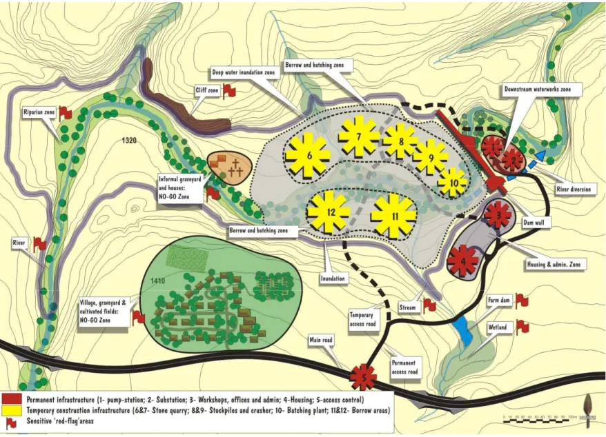
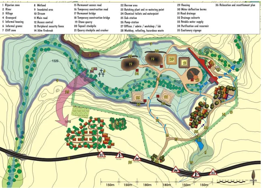
Depending on the specific requirements of the project, Sketch Plans (large-scale plans that describe the design details for a specific area of the Master Plan), Sections, Elevations and Perspective Sketches may be required to support the Master Plan. This plan, originally developed by the Environmental Planner, is essentially a refined Master Plan which details and quantifies all aspects of construction related to the project (see Figure 4). For smaller projects, or as specified by the Environmental Planner, the ESM&R Plan may be included in the Master Plan.
The ESM&R plan must be such that both the tender document and the Environmental Memorandum can be better understood. For smaller projects, or as indicated by the Environmental Planner, the Water Management Plan can be included in the ESM&R Plan. The master planning process should be carried out by a multidisciplinary team consisting mainly of the environmental planner, the design engineer and the social officer.
Development within floodplains
ENVIRONMENTAL CODE OF CONDUCT
- General conduct
- Health and safety
- Safeguarding sensitive environments
- Safeguarding flora
- Safeguarding fauna
- Managing waste and pollution
- Managing roads and access
- Managing prospecting boreholes, excavations and test pits
- Rehabilitation
- Interaction with landowners and stakeholders
Permission must be obtained from the offspring (if known), the National Ministry of Health, the Provincial Ministry of Health, the Premier of the province and the local police. Where damage to plant species and communities is a concern, these should be demarcated with hazard tape and steel drippers, or cordoned off at a distance from the outer IV line. Ensure that dams cause minimal disturbance to flow patterns both upstream and downstream of the crossing and do not cause damming of the water at the crossing.
In such a situation, be sure to return the wetland / drainage line profile to a profile similar to the pre-construction profile. Tear up39 and/or crush40 all affected areas, including temporary access roads and roads, compacted during the execution of the works (preferably before the rainy season). 40 Roughening the surface of the soil to a depth of about 50 mm, which creates a smoother surface than raking.
MONITORING AND AUDITING
- Introduction
- Roles and responsibilities
- Land owner or Custodian of the Land
- Developer or Implementing Agent
- Environmental Consultant
- Project Manager
- Design Engineer
- Environmental Planner
- Contractor
- Site Engineer
- Environmental Officer
- Environmental Control Officer
- Operator
- Environmental Manager
- The Monitoring Procedure
- The Auditing Procedure
In some cases, the site engineer may also assume the responsibilities of the project manager. An Environmental Control Officer will undertake environmental audits for the duration of the Construction Contract and the operational life of the project as required. An Independent Environmental Control Officer or External Auditor is an unaffiliated party who will undertake environmental audits for the duration of the project as required.
Normally, the environmental manager will carry out environmental audits throughout the duration of the planning process as needed. Monitoring reports will be submitted to the Project Manager who will deal with the issues and retain the reports to be made available upon request by the landowner/land manager and any environmental authority or I&AP that requests it. Audit reports will be submitted to the Project Manager who will deal with issues and retain the reports to be made available upon request by the landowner/land manager and any environmental authority or I&AP that requests it.
CONCLUSION
ASSESSMENT OF THE PRIORITY CONSERVATION STATUS OF THE SOUTH AFRICAN Estuaries FOR USE IN MANAGEMENT AND WATER ALLOCATION. ENVIRONMENTAL MANAGEMENT AND REHABILITATION SPECIFICATIONS (ESM&RS) FOR DWAF SITES AS PART OF THE ENVIRONMENTAL MANAGEMENT FRAMEWORK.