454
HISTORICAL FLOOD RISK MANAGEMENT: SPATIAL
EXPANSION OF GHERGHI
ȚA VILLAGE
(LOWER PRAHOVA RIVER)
IOANA-TOROIMAC GABRIELA 1
ABSTRACT. – Historical flood risk management: spatial expansion of Gherghiţa village (Lower Prahova River). This paper analyses settlements expansion in flood zones during historical time. We focused on the example of Gherghiţa village on Lower Prahova River by using a diachronic study in GIS. It revealed three major periods of extension of Gherghița village and flood risk management: (1) from Middle Age to the end of the 19th century – prevention against floods by expansion outside the flood-prone area; (2) during the major part of the 20th– flood negligence by expansion inside the flood-prone area; (3) at the end of the 20th century and at the beginning of the 21th century – protection against floods by extension inside the flood-prone area with structural measures (i.e. levees). As a consequence, human pressure on Lower Prahova River grew since the beginning of the 20th century, especially for agricultural purposes.
Keywords: diachronic approach (Middle Age – 21th century), flood-prone area, prevention / protection, human pressure, GIS.
1. INTRODUCTION
Settlement expansion in flood zones is an important component of flood risk management, because it is associated to various structural protective measures with impact on natural functioning of rivers (Früh-Müller et al., 2013). Geohistorical approach revealed various moments in the conquest of floodplains throughout Europe. For example, in Middle Age, major anthropic interventions have already taken place on some watercourses and their floodplains: on Danube in Hungary (Kiss, 2011); in Po Valley in Northern Italy (Curtis and Campopiano, 2014); in England and Wales (Lewis, 2010). In Main valley (Germany), expansion of settlements in flood zones, increasing demands for protection against floods and growing human pressures on rivers occurred after 1850 (Früh-Müller et al., 2013).
Regional studies showed that, generally, rivers from the south-eastern part of Europe still have intact landscapes (River Watch, 2012). In this context, the aim of our study is to determine when settlements extended in flood zones and, therefore, when human direct pressure started to trigger on these rivers.
1
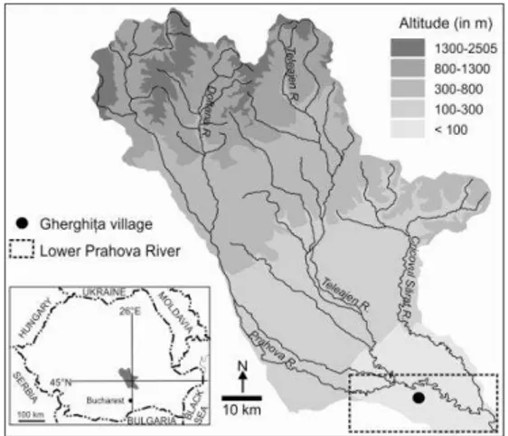
455 Our study focuses on the example of Gherghiţa village on Lower Prahova River (Fig. 1). It emerged as a market town in 14th century at a major crossroads and became a royal residence in 15th-16th centuries (Rădvan, 2010). Today, it has almost 2000 inhabitants (with the other villages forming a commune) and an agricultural economic profile (INS, 2013). The northern part of the village was affected by Prahova’s overflowing in July 1975 and September 2005; in 2005, two houses were destroyed and 82 were affected in 70% (Ioana-Toroimac, 2009).
2. DATA AND METHODS
To determine the data of village expansion towards the flood zone, we employed a diachronic study. We used six documents from 1864-2011 time horizon: Southern Romania Map, Military Survey Map, two editions of topographic maps, orthophotos, and Google satellite images (Table 1). All the documents have initial different projections and they were converted in Stereo 70: Southern Romania Map by Bartos-Elekes et al. (2014), Military Survey Map by Crăciunescu et al. (2011), topographic maps within this study, orthophotos by National Agency for Cadaster and Land Registration; Google images were seen by using Pseudo Mercator within Quantum GIS. Only two elements have the same position on all the documents (i.e., two medieval churches); therefore, the comparison is difficult, especially between old and recent documents.
Within the diachronic study, we created eight layers. Churches were selected on all the documents. Buildings (including annexes and agricultural greenhouses), roads, river channel and scarps were digitized function of their representation on each document. Flood-prone area boundary, corresponding to 0.5 m water depth, was redrawn based on ANAR (2014). The position of archeological excavations comes from INP (2014). Levees were measured during field surveys of 2007.
The results of the diachronic study should be interpreted with certain precaution due to differences between documents: they have different initial projections, they have different scales, and elements are differently represented. For example, scarps are represented only on 1864 and 1899 maps; buildings are represented as quarters on 1954 and 1980 maps; building have a higher density on orthophotos and satellite images of 2005 and 2011 due to their detailed scale.
456
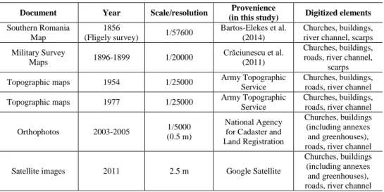
Table 1. Documents used in this study
Document Year Scale/resolution Provenience
(in this study) Digitized elements Southern Romania
Map
1856
(Fligely survey) 1/57600
Bartos-Elekes et al. (2014)
Churches, buildings, river channel, scarps
Military Survey
Maps 1896-1899 1/20000
Crăciunescu et al.
(2011)
Churches, buildings, roads, river channel,
scarps
Topographic maps 1954 1/25000 Army Topographic
Service
Churches, buildings, roads, river channel
Topographic maps 1977 1/25000 Army Topographic
Service
Churches, buildings, roads, river channel
Orthophotos 2003-2005 1/5000
(0.5 m)
National Agency for Cadaster and Land Registration
Churches, buildings (including annexes
and greenhouses), roads, river channel
Satellite images 2011 2.5 m Google Satellite
Churches, buildings (including annexes
and greenhouses), roads, river channel
3. RESULTS
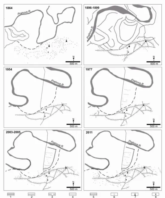
Lateral migration of Prahova River is indicated by meander scars (Fig. 2). Between 1864 and 1899, Prahova cut-off a meander in the southern part of the study area. Between 1899 and 1954, it invaded an older cut-off meander in the south-western part of the study area. Since 1954, lateral migration of meanders became less intense.
Flood-prone area boundary from the right side of Prahova River seems to correspond to abandoned channels of Prahova River. It includes the fluvial space used by the river for successive lateral migrations.
Buildings from Middle Age Gherghiţa were probably situated away from the flood-prone area as it is showed by the position of archeological excavations and two medieval churches (Fig. 2). This situation continued to the end of the 19th century. In the 20th century, buildings started to expand in the flood-prone area, previously uninhabited, in three phases: (a) between 1899 and 1954, in the north-western part of the village, along one of the main streets; (b) between 1954 and 1977, in the northern part of the village; (c) between 1977 and 2011, in the north-western part of the village. The location of new buildings from the first part of the 20th century maintained until the beginning of the 21st century. However, from the number of buildings digitized, those located in flood-prone area represented: 1.4% in 1954, 11.1% in 1977, 12% in 2005, and 9.5% in 2011.
457
Fig. 2. Evolution of Gherghița village compared to flood-prone area. 1: river channel; 2: scarp (probably meander scar); 3: flood-prone area boundary (water depth = 0.5 m; redrawn from ANAR, 2014); 4: road; 5: levee; 6: building (or annexes, or greenhouses);
458
4. DISCUSSION
The diachronic study revealed three major periods of spatial expansion of Gherghița village: from Middle Age to the end of the 19th century – outside the flood-prone area; during the major part of the 20th– inside the flood-prone area; at the end of the 20th century and at the beginning of the 21th century – inside the flood-prone area with protection measures against floods (i.e., levees), impacting on river natural dynamics.
459
Fig. 3. Historical phases of flood risk management in Gherghiţa village. LR: land reform; F-L: levees for protection against floods
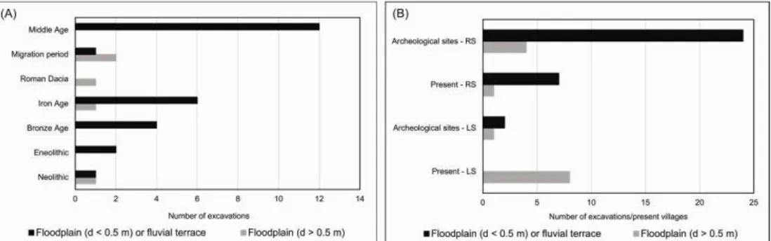
The results for Gherghiţa village may be extrapolated for Lower Prahova River: local medieval population preferred to prevent the flood risk rather than protect from it like contemporary society. All archeological excavations from Middle Age are located in the exceptional floodplain (water depth < 0.5 m) or on fluvial terraces (Fig. 4A); actually, settlements from southern Romania Middle Age were near water sources, often aligned on terraces upon the everglades of rivers or next to lakes (Fieldler, 2008). At present, all villages located on right side of Lower Prahova River are outside flood-prone area, except for Gherghiţa (Fig. 4B).
Fig. 4. Settlements’ exposure to floods on Lower Prahova River. (A) Excavations within archeological sites located in the vicinity of Lower Prahova River (position and age of
excavations according to INP, 2014; position compaired to the the flood-prone area according to ANAR, 2014; d: water depth). (B) Excavations and villages located in the vicinity of Lower Prahova River with built-up area exposed to floods (position compaired to the the flood-prone area according to ANAR, 2014; d: water depth; RS: right side; LS:
left side)
460
5. CONCLUSION
In Gherghița village, settlements expansion in flood-prone area started in the first part of the 20th century and has been increasing since. The main local measure with impact on river channel is levees’ construction for protection against floods, at the end of the 20th century.
However, in Gherghiţa, only a small part of the village (a maximum of 12% of buildings in 2005) is located in flood zone and flood protection measures act on a local spatial-scale. This advantage, consisting in a traditionally prevention strategy face to flood risk, should be preserved. Therefore, flood risk management and spatial extension of settlements in flood zones should be better related through spatial planning.
Acknowledgments
This work was supported by the strategic grant POSDRU/159/1.5/S/133391, Project “Doctoral and Post-doctoral programs of excellence for highly qualified human resources training for research in the field of
Life sciences, Environment and Earth Science” cofinanced by the European Social
Found within the Sectorial Operational Program Human Resources Development 2007 – 2013. We thank Cezar Buterez for helpful comments on the GIS part of the manuscript.
REFERENCES
1. ANAR (Admnistrația Națională Apele Române) (2014), Hărți de hazard și risc la inundații. http://gis2.rowater.ro:8989/flood/ accesed on December, 24, 2014. 2. Bartos-Elekes, Z., Timar, G., Imecs, Z., Magyari-Saska, Z. (2014), Fligely’s
Topographic Mapping of Walachia (1855–1859), Szathmári’s Map of Southern
Romania (1864), its Geo-referencing and Publishing on Web (2011–2014).
http://www.charta1864.ro/index.html accesed on December, 24, 2014.
3. Buşă, D. (coord.) (2006), Călători străni despre ările Române în secolul al XIX -lea. Edit. Academiei Române.
4. Crăciunescu, V., Rus I., Constantinescu, Ş., Ovejanu, I., Bartos-Elekes, Z. (2011), Planurile Directoare de Tragere. http://earth.unibuc.ro/download/planurile-directoare-de-tragere accesed on December, 24, 2014.
5. Curtis, D.R., Campopiano, M. (2014), Medieval land reclamation and the creation of new societies. Comparing Holland and the Po Valley, 800-1500. Journal of Historical Geography 44, 93-108.
6. Fieldler, U. (2008), Bulgars in the Lower Danube Region. A survey of the Archeological evidence and of the state of current research. In Curta, F. (ed.), The other Europe in the Middle Ages. Avars, Bulgars, Khazars and Cumans, Brill, Boston, Leiden, 159-162.
461
8. Gavrilă-Ardelean, M., Gavrilă-Ardelean, L. (2013), Habits in Romanian traditional community village, Agora Psycho-Pragmatica 7, 2, 59-73.
9. Haslett, S.K. (2011), Holocene sedimentation in a pericoastal river system (South Wales, UK): relationship to sea level, human activity and coastal sediment flux. In Brown, A.G., Basell, L.S., Butzer, K.W. (eds.), Geoarcheology, climate change and sustainability, Special Paper 476, The Geological Society of America, Colorado, 93-103.
10. INP (Institutul Național al Patrimoniului) (2014), Repertoriul archeologic național. http://ran.cimec.ro/ accesed on December, 24, 2014.
11. INS (Institutul Naţional de Statistică) (2013), Recensământul populaţiei şi locuinţelor 2011. Judeţul Ialomiţa. Judeţul Prahova. http://www.rpl2011.djsct.ro/ accesed on December, 24, 2014.
12. Ioana-Toroimac, G. (2009), La dynamique hydrogéomorphologique de la rivière Prahova (Roumanie): fonctionnement actuel, évolution récente et conséquences géographiques. Thèse de doctorat en Géographie, Université Lille 1.
13. Kiss, A. (2011), Floods and long-term water-level changes in Medieval Hungary. PhD Thesis, Central European University.
14. Lewis, J. (2010), Medieval environment impacts and feedbacks: the lowland floodplains of Englang and Wales. Geoarchaeology: An International Journal 25, 3, 267-311.
15. Olteanu, S., Grigore, N. (2002), Gherghi a. Jude Prahova. Punct: Şcoala
Generală: anul 2002. http://cronica.cimec.ro/detaliu.asp?k=1960 accesed on
December, 29, 2014.
16. Puşcaşu, V. (2009), Common, parallel an convergent evolutions for spatial planning in Romania and Moldavia. Romanian Review on Political Geography 11, 1, 46-57.
17. Puşcaşu, V. (2010), Rural planning in Romania. MRPA Paper no. 53220.
18. Rădvan, L. (2010), At Europe’s borders. Medieval towns in Romanian Principalities. Koninklijke Brill NV, Leiden.
19. River Watch (2012), River assessment in the Balkan region. http://riverwatch.eu/en/balkan-rivers/studies accessed on December, 24, 2014. 20. Turnock, D. (1979), Water resource management problems in Romania.
GeoJournal 3.6, 609-622.