www.nat-hazards-earth-syst-sci.net/11/2321/2011/ doi:10.5194/nhess-11-2321-2011
© Author(s) 2011. CC Attribution 3.0 License.
and Earth
System Sciences
A comparison of the causes, effects and aftermaths of the coastal
flooding of England in 1953 and France in 2010
D. M. Lumbroso1,2and F. Vinet3
1HR Wallingford, Howbery Park, Wallingford, Oxfordshire OX10 8BA, UK
2ILUNAM Universit´e, Institut Franc¸ais des Sciences et Technologies des Transports,
de l’Am´enagement et des R´eseaux (IFSTTAR), GER, 44341 Bouguenais, France
3Unit´e Mixte de Recherche, Gouvernance, Risque, Environnement, D´eveloppement (GRED),
Institut de Recherche pour le D´eveloppement (IRD), Universit´e Paul-Val´ery Montpellier III, France Received: 11 March 2011 – Revised: 14 June 2011 – Accepted: 20 July 2011 – Published: 25 August 2011
Abstract. This paper provides a comparison of the causes, effects and aftermaths of the coastal flooding that occurred on the east coast of England in 1953 and the west coast of France in 2010 that resulted in 307 and 47 deaths respectively. The causes of both events are strikingly similar. Both were caused by a combination of high tides, low atmospheric pressure, high winds and the failure of poorly maintained flood de-fences. In both cases the number of deaths was related to the vulnerability of the buildings and people. Buildings in the flood zones were often single storey bungalows and the peo-ple who died were mostly over 60 yr of age. Both tragedies were national disasters. The 1953 flood in England acted as a catalyst for an acceleration in flood risk management pol-icy and practice. It resulted in: the development of a Storm Tide Warning System for the east coast of England; the set-ting of new design standards for coastal flood defences; in-creased investment in improving coastal defences; and a sub-stantial new research effort into coastal processes, protection and forecasting. In France there has also been an episodic shift in flood risk management policy with the focus falling on: control of urban developments in areas at risk of flood-ing; improved coastal forecasting and warnflood-ing; strengthening of flood defences; and developing a “culture of risk aware-ness”. This paper outlines the lessons that can be learnt from the two events and provides recommendations concerning how future loss of life as a result of coastal flooding can be reduced.
Correspondence to:D. M. Lumbroso (d.lumbroso@hrwallingford.co.uk)
1 Introduction
The storm surge that struck the east coast of England and the south-west coast of the Netherlands during the night of Sat-urday 31 January 1953 caused the worst natural disaster in northern Europe of the past two centuries. In eastern Eng-land 307 lives were lost, more than 32 000 people were evac-uated, 24 000 houses were damaged, 46 000 livestock were killed, 160 000 acres of agricultural land were flooded with salt water, and major transportation links were impassable (Summers, 1978). The damage has been estimated at £5 bil-lion in today’s money (RMS, 2003).
On 28 February 2010 at 2 o’clock in the morning the “tempˆete” (storm) Xynthia hit the French Atlantic coast. The storm surge combined with a high tide and large waves caused flood defences to fail along the coast from the Gironde near Bordeaux to the Loire Estuary. Over 50 000 ha of land were flooded and 47 people died as a result of the storm. Most people died as result of the flooding although a small number of people died as a result of storm debris. The French Departments of Vend´ee and Charente-Maritime suffered the most damage (Kolen et al., 2010). It has been estimated that the damage caused by the flooding may have cost in excess of C1.2 billion (Le Figaro, 2010a).
London
Canvey Island – 58 dead Jaywick – 37 dead
River Ouse
Harwich
Felixstowe – over 40 dead Southwold
Great Yarmouth
River Yare
0 10 20 30 40
miles Area flooded
King’s Lynn Heacham Hunstanton
Wells Sutton-on-Sea Mabelthorpe Saltfleet
65 dead Over 16 dead
Lowestoft
North Sea
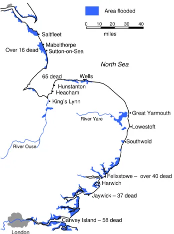
Fig. 1.Area flooded and the loss of life in east England as a result of the 1953 coastal floods.
informed largely by assessing and reducing the flood risk of areas where people live and work, and the infrastructure on which they depend (DEFRA, 2008a). The paper considers whether the lessons learnt and policies adopted by the British Government after the 1953 event are relevant to France and its current policy on flood risk management. The paper also provides a series of conclusions and recommendations.
2 Nature of the flood hazard
2.1 The Great North Sea Floods in England in 1953 Storm surges present a very specific type of flood hazard to the east coast of England, a hazard that can be more severe than coastal floods seen elsewhere around the British Isles, mainly because of the semi-enclosed funnel shape, and the shallow nature of the North Sea (Baxter, 2005). The Great North Sea Flood in England was caused by a storm surge that was the result of wind pushing the sea towards the coast, coupled with low air pressure and a high astronomical tide. From 06:00 pm on the evening of 31 January 1953, winds drove the storm surge southwards along the east coast reach-ing Canvey Island just after midnight on 1 February 1953 (Grieve, 1959).
Fig. 2.Typical breach in the flood defences during the 1953 floods.
The high water levels associated with the combination of storm surge and tide had not been foreseen in the design of coastal flood defences, which were unable to hold back the water in many places. The 1953 storm surge produced high water levels not seen for the previous 250 yr along the coast of East Anglia. The surge affected 1600 km of the coastline of eastern England (Muir Wood et al., 2005).
By the end of World War II, Britain’s coastal flood de-fences were in a fairly neglected state (Kraus, 1996). The Great North Sea Flood highlighted the inadequacy of coastal defences in place in the UK at the time. It caused an esti-mated 2000 breaches in the natural and artificial flood de-fences (Muir-Wood et al., 2005). Along the estuaries of Es-sex, there were 839 breaches up to 45 m in width and extend-ing from 1.5 to 6 m in depth below the former defence crest (Cooling and Marsland, 1954).
Several mechanisms contributed to the defence failures. In some cases, the powerful surge and associated waves scoured the seaward face of the defences while water that had over-topped or flowed through cracks and permeable layers eroded the inland face, leading to damage and collapse. Elsewhere, sand and earth fillings were washed out, undermining the em-bankments leading to their collapse (Muir Wood et al., 2005). People were taken by surprise by the floods owing primarily to the sudden breaching of flood defences and the lack of forecasting and warning systems.
Figure 1 shows the area inundated and the location of the fatalities as a result of the 1953 floods (Steers, 1953). Figure 2 shows a photograph of flood defences that were breached in the 1953 event.
2.2 Background to the flooding caused by “tempˆete” Xynthia in France in 2010
0 10 miles 29 dead – La Faute sur Mer
Ile de Ré
L’Aguillon sur Mer
Vendée
La Rochelle
Atlantic Ocean Charente-Maritime
Area flooded
Disaster area
Gironde Charent-Maritime Vendée Loire -Atlantique
Ile d’Ouléron
2 dead – La Flotte
3 dead – Charron 1 dead – Esnandes
1 dead – Boyardville
2 dead – Châtaillon-plage 3 dead – Aytré
Fig. 3.Area flooded and the loss of life as the result of Xynthia in 2010.
2010 were in a similar, if not worse, state to those in the UK in 1953. Many of the coastal flood defences that are along the French Atlantic coast date back to the Napoleonic era. Most of the coastal dikes were built originally to pro-tect agricultural land, but with the increasing urbanisation of the Atlantic coast in the past 30 yr their primary purpose has changed. Flood defences that were adequate for agricultural land were not suitable for the protection of new housing de-velopments.
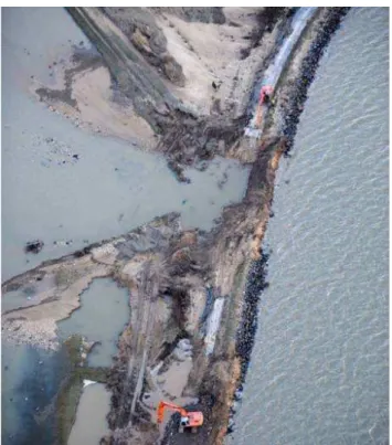
A combination of high tides, low atmospheric pressure coupled with high winds and the failure of coastal flood de-fences led to widespread flooding along the coast of Vend´ee and Charente-Maritime and the deaths of 47 people. The in-undated area in these two Departments is shown in Fig. 3 (Mercier and Acerra, 2011). It has been estimated that 75 km of dikes out of a total of 103 km in Vend´ee and 120 km of dikes of the 224 km in Charente-Maritime needed to be re-built or strengthened following the storm. Figure 4 shows an aerial photograph of a breach in a flood defence in Vend´ee. In some houses in La Faute-sur-Mer, the water level rose to a depth of 2.5 m within half an hour following the failure of dikes. Some people woke up to find their beds floating 1.5 m above the floor (Kolen et al., 2010).
Around 10 000 people were forced to evacuate their homes on the Atlantic coast. The French government declared a “Catastrophe Naturelle” in four Departments (Charente-Maritime, Deux-S`evres, Vend´ee and Vienne). It was re-ported that more than 9000 French fire fighters and emer-gency workers backed up by helicopters were deployed on 1 March 2010 to reach residents stranded on rooftops, mostly in Vend´ee and Charente-Maritime (MEEDDM, 2010). Hun-dreds of families in coastal regions spent the night in shelters that were set up in schools and public buildings.
Sea defences in France are currently owned by an eclec-tic range of communities, property owners and individuals, most of whom do not have the necessary financial means
Fig. 4. Aerial view of the damage to a section of coastal flood de-fences in Vend´ee.
to maintain them. Approximately 3000 km of defences are classed as “orphelines” (orphans) by the French Government because their ownership is not known (MEEDDM, 2011).
3 Exposure to flooding
0 500 1000 1500 2000 2500
1950 1960 1970 1980 1990 2000 2010
Year
N
u
m
b
er of pr
operties
Total number of properties in La Faute sur Mer
Total number of properties in the area of La Faute sur Mer that were flooded in 2010
Fig. 5.Growth in the number of properties at La Faute-sur-Mer.
As a result of the increasing urbanisation of the coast, the number of dwellings in the area flooded in 2010 in La Faute-sur-Mer increased from 508 in 1980 to 1227 in 2010. Be-tween 1990 and 2000, 266 out of 409 new dwellings con-structed in La Faute-sur-Mer were built in flood prone areas. After 2000 the number of buildings built in the 2010 flood zone decreased. However, this decrease in urbanisation was not as a result of any spatial planning land controls or due to an increase in the awareness of the flood risk but as a re-sult of a decrease in the amount of land that was available to develop. In 2010, in the southern part of La Faute-sur-Mer, where the highest water levels were recorded in 2010, (approximately 3 m), some houses were still being built on the remaining free parcels of land. It should be noted that many of the new houses built in La Faute-sur-Mer are sec-ond homes so it is difficult to assess the occupancy rate when Xynthia hit. However, anecdotal information, collected by the University of Montpellier, indicates that it was around 30 %. Another reason for the increase in urban develop-ment in coastal areas prone to flooding is peri-urbanization. For example this is the case for the town of La Rochelle in Charente-Maritime. As the town grew and the price of real estate rose, developments began to be constructed in previ-ously undeveloped coastal zones, where land was less ex-pensive.
4 Vulnerability of the buildings and people 4.1 Vulnerability of buildings
In 1953 in England most of the houses in the communi-ties worst affected by the flooding were constructed using flimsy, wooden frames or were prefabricated bungalow. Of the 307 deaths, at least 216 (70 %) occurred in five main clus-ters: Mablethorpe and Sutton-on-Sea (16 dead), Hunstanton and Snettisham on the Wash (65 dead), Felixstowe and Har-wich (over 40 dead), Jaywick (37 dead) and Canvey Island
Fig. 6. A typical wooden house that was swept away in the 1953 flood.
(58 dead) (Baxter, 2005). At the time, prefabricated build-ings in these communities were commonplace owing to the housing shortage following the Second World War. On Can-vey Island, the most vulnerable dwellings were rudimentary, single-storey structures that had been built as cheap retire-ment homes for workers from the east end of London, for whom the island had become a retirement paradise (Kelman, 2002). Pollard (1978) states that “the Mablethorpe Sutton area of Lincolnshire, the Hunstanton to Lynn area, Jaywick, Canvey Island – were largely seaside shanty-towns consist-ing mainly of timber bungalows never intended for winter occupation”. A view of a typical timber house that was moved more than 300 m by the flood water in 1953 is shown in Fig. 6. Death tolls were highest in communities with low-quality buildings. For example, 39 fatalities occurred in the Felixstowe on a housing estate comprising prefabricated houses. On Canvey Island, the death toll amounted to 58, with many people surprised in their houses, several of which collapsed, after sea defences failed.
The type of housing stock affected by the Xynthia flood event in 2010 was similar to those affected by the 1953 flood in that 32 of the 41 people who died lived in bungalows. Sim-ilar to the 1953 flood, the sea surge occurred at night and many people were surprised sleeping in their homes. The majority of the houses in the inundated area had been fitted with electric shutters and had no access to the roof which turned them into traps, as vertical evacuation to avoid the floodwater became almost impossible. A typical view of bungalows in La Faute-sur-Mer located directly behind flood defences is shown in Fig. 7.
Fig. 7. Single storey houses located behind coastal flood defences in La Faute-sur-Mer.
many communes, local planning regulations prevented con-struction of an upper floor. The mayor of l’Aiguillon, Mau-rice Milcent, said “The breach in our sea wall was not the problem! The waters just rose at once, overflowing our com-munities, built on swamps, in a flood-prone area. The prob-lem has been known since Napoleon’s time. According to our regional construction codes, houses had to be “fisher-men style” (i.e. bungalows) (Coastal Care, 2011). Table 1 clearly shows the link between the vulnerability of the build-ings and the number of deaths.
4.2 Vulnerability of people
In the cases of the 1953 and 2010 floods the vulnerability of people also played a large part in the number of deaths that occurred. Pollard noted that for the 1953 flood in England that “the eventual death tolls showed that it was the elderly, who went to bed early and had meagre reserves of energy even if they had time to realise what was happening when the water hit them, who were most vulnerable” (Pollard, 1978). On Canvey Island, 42 out of 58 fatalities were aged over 60. The highest proportional death rate along the whole flooded coast was at Jaywick where 36 (5 %) out of 700 residents died, with all the deaths being attributed to drowning. Of these, 82 % of victims were aged 60 yr and over, and in the youngest age groups, under 44, the dead comprised two peo-ple who were described as disabled, one woman in an ad-vanced state of pregnancy, two adults who died trying to save others and one child aged 11 (Baxter, 2005; Grieve, 1959). In south Lynn, all 14 fatalities were over 60. Deaths were not necessarily caused by drowning. Of the 41 post mortems carried out at Canvey Island, 14 people died of other causes than drowning, such as shock and heart attack (Jonkman and Kelman, 2005). Figure 8 shows the ages of the people that died at Canvey Island and Jaywick.
0 5 10 15 20 25 30 35 40
<6
≥6 to 12
≥13 to 19
≥20 to 29
≥30 to 39
≥40 to 49
≥50 to 59
≥60 to 69
≥70 to 89
Ag
e ran
g
e (years)
Number of deaths
Fig. 8. Age of the people who died in the 1953 floods at Canvey Island and Jaywick.
In the Departments of Charente-Maritime and Vend´ee there were 41 deaths related to the 2010 coastal surge of which 29 occurred in the town of La Faute-sur-Mer in Vend´ee and 12 in the Department of Charente-Maritime. In La Faute-sur-Mer, 28 out of the 29 fatalities occurred in an area mea-suring 3 ha that became known as the “bowl of death” by the media and political authorities. Figure 9 shows the age and sex of people who died in the 2010 floods in France. It is important to note that no official data was collated by the French Government on the fatalities. The data in this paper were collected by researchers from the University of Mont-pellier who, working with local stakeholders such as the fire service, compiled the information in the six months after the floods occurred.
For the 2010 event in France, 71 % of the people who died were aged over 60. The median age of the victims was 75, which is high taking into account that the median age of the communities where fatalities occurred is 52 and that the median age of the French population is 38 yr old (IN-SEE, 2007). In the town of La Faute-sur-Mer, people aged over 74 comprised only about 16 % of the total population. However, it should be noted that the flooding occurred during the school holidays and no information was available on the “non-resident” population who may have been on holiday at the time. In La Faute-sur-Mer, it was possible to determine from land registry datasets that at least 20 out of 29 victims were local residents. Figure 9 shows that there were no vic-tims in the age range 20 to 40. The five fatalities aged less than 20 were children on holiday with their parents or grand-parents. The age distribution of the victims is very similar to the 1953 flood where there was also an over-representation of elderly people.
Table 1.Number of deaths and the types of building they occurred in during Xynthia.
Type of building Bungalow Bungalow with one upper
room acting as a refuge
Houses with an upper floor Others (e.g. caravans)
Number of deaths 32 4 3 2
Age range (years)
>80
>60 to 80
>40 to 60
>20 to 40
<20
0 1 2 3 4 5 6 7 8
Number of men 0 1 2 3Number of women4 5 6 7 8 8 7 6 5 4 3 2 1 0 0 1 2 3 4 5 6 7 8
Men Women
Fig. 9. Age and sex of the people who died in the 2010 coastal floods caused by Xynthia.
flood risk management policy changes or for fundamental changes in policy. A flood is defined as a “crisis” if its scale and its impacts are of more than regional significance, and recognised by the national Government as such (Johnson et al., 2002). Policy change acceleration as the consequence of a major flood emergency is not necessarily based on the development of new ideas but can help to promote existing ideas that are already the subject of widespread discourse within the framework of an existing flood risk management policy (Penning-Rowsell et al., 2006). The East Coast flood of 1953 and the “tempˆete” Xynthia events were certainly ex-ceptional floods in recent history, both in their nature, sever-ity and impact. The responses to the two floods are detailed below.
The 1953 flood in England led to the following accelerated policy initiatives and responses:
1. The development of a Storm Tide Warning System for the east coast of England.
2. The setting of new design standards for coastal flood defences at the 1953 level.
3. Investment in improving and strengthening coastal flood infrastructure.
4. A substantial new research effort into coastal processes, protection and forecasting.
In 1953 in the UK there was no national flood warning service or coordination. Flood defence was organised by a
number of River Boards. They had emergency plans but they were not linked up on a national basis. Emergency plans were hampered by communications failures in most locations (Environment Agency, 2009a). One of the British Govern-ment’s primary concerns after the 1953 flood was to set up a coastal flood warning system. The 1953 flood led directly to the creation of the Storm Tide Warning Service, a national flood warning organisation, created to improve the accuracy and efficiency of coastal surge warnings to the public as well as the authorities. Just ten days after the flood, the Gov-ernment announced emergency arrangements as a “stop-gap” before a more permanent system could be devised (Penning-Rowsell et al., 2006).
Although at the time of the 1953 flood a rudimentary surge flood warning system was in place for London (Waverley, 1954), little thought had been given to a more accurate and far reaching system covering the east coast of England. This was partly because at the time storm, surges in the North Sea were poorly understood and there was no appropriate medium for communicating the warnings as the fledging, national radio system was not considered to be appropriate (Penning-Rowsell, 2006; Waverley, 1954). Soon after 1953 a network of tidal gauges was installed around the British Isles’ coastline to provide accurate water height measurements and connect weather forecasts with tidal movements. This net-work can now provide warnings up to 12 h in advance of an extreme storm surge. A system of sirens originally set up for civil defence purposes along the east coast was expanded and used to provide warnings to communities of any extreme floods following the 1953 event. The minutes of the Waver-ley Committee set up to investigate the 1953 flood indicate that many of the policy changes were driven by Proudman and Steers, a University of Liverpool oceanographer and a University of Cambridge Geographer, respectively.
standards for flood defences had been debated since the Great Flood of 1947 that were the most catastrophic river floods for at least 200 yr in the UK (RMS, 2007). It would appear that the use of the 1953 level did not come about as the result of a scientific debate but because it would have been politically impossible to suggest a lower level (Johnson et al., 2002). The 1953 flood thus resulted in evidence-based standards of coastal flood defences with this level being the maximum level provided unless benefits gained by having higher de-fences could be adequately demonstrated.
Although central London had escaped the flood in 1953, the vulnerability of the city was highlighted to politicians. If the tidal surge had reached central London, the death toll and damage could have been significant. Over a million people would have been in danger. The probable damage to Lon-don’s infrastructure including water and sewage system, un-derground, gas and phone lines would have disrupted life in the capital for months and been costly to repair.
The 1953 flood acted as a catalyst for Britain’s largest ever coastal defence improvement programme. In the years fol-lowing the 1953 flood, coastal defences were raised by up to two metres in areas where the risk (i.e. the number of peo-ple) was highest (RMS, 2003). In many places the coastal defences were improved so that they could protect against storm surges with an annual probability of up to 1 in 1000 yr. After the floods, an enquiry was set up to work out ways of protecting London in the future. As the old system of embankments was clearly no longer adequate, the enquiry recommended the construction of a flood barrier across the Thames.
The fourth aspect of the 1953 flood was the increase in the coastal research effort following the flood. After 1953 the Proudman Laboratory at Liverpool University developed the use of approximate statistical methods for the east coast of England and their continuing research led to the world’s first storm-surge prediction scheme based on a numerical model being set up in 1978 and which has been upgraded ever since (Jones, 1999). Other areas of coastal research that com-menced included long-term sea-level change (Jones, 1999).
Similar to the 1953 floods in Britain, the floods caused by Xynthia have acted as a catalyst for change in France. Xynthia caused the worst ever coastal flooding in terms of mortalities recorded to date. An historical study of coastal surges by Garnier and Surville (2010) indicates that there has been no previous coastal surge in France with such a high death toll (Garnier and Surville, 2010). The French Govern-ment declared the 2010 floods a “natural catastrophe” so it will be interesting to note if they also have the same long-term impact that the 1953 flood had on flood risk manage-ment policy in the England. One immediate response to the Xynthia flood was that the French Government announced on 8 April 2010 that it had decided to destroy 1510 houses in the affected areas of which 823 were in the Vend´ee and 595 were in Charente-Maritime. The government promised to fully compensate all home-owners, based on the value of
the real estate prior to the storm with the ministry of finance stating that they would pay C250 000 per house (MEEDDM, 2010). To date in Vend´ee of the 823 homes designated by the French state to be destroyed, nearly 700 homeown-ers have accepted the compensation terms by the state with demolition taking place in March 2011. There remain 79 people who have decided to take the matter further legally (http://Lafautesurmer.net, 2011).
In February 2011 the French Government produced a document called “Plan submersions rapides: Submersions marines, crues soudaines et ruptures de digues” (Rapid in-undation plan: coastal floods, flash floods and dike failures) (MEEDM, 2011). This plan details the policy response brought about not only as a result of Xynthia in Febru-ary 2010, but also severe flash flooding in the Var Depart-ment in southern France in June 2010 that led to the deaths of 25 people. There are four priority areas detailed in the plan as follows:
1. Control of urban developments in areas at risk of flood-ing.
2. Improvements in coastal forecasting and warning. 3. Strengthening of flood defences.
4. Developing a “culture of risk awareness”.
In terms of the control of urban development in flood haz-ard zones, the French Government has stated that there will be a concerted effort to complete “Plans de Pr´evention des Risques Littoraux” (PPRL), i.e. coastal flood risks plans. The goal is that within three years, 242 new coastal communities will be covered by a risk prevention plan and that the exist-ing plans of a further 68 communes will also be revised. The government will introduce a law meaning that the construc-tion of new coastal flood defences to allow new areas adja-cent to the coast to be developed will be prohibited. By the end of 2011, the French Government will also have a tech-nical reference document in place to assist professionals in providing flood risk management solutions.
will put in place a programme to improve the real time mon-itoring of coastal surges and warnings for the areas with the highest risk along the French coast.
One of the many criticisms following Xynthia was that no warning was given concerning the possibility of coastal flooding. The French Government has stated that by the end of 2011, M´et´eo France will be in a position to deliver a specific weather warning related to “coastal flooding”. For each coastal Department M´et´eo France will provide a colour-coded warning (i.e. green, orange or red) based on the fore-cast sea level and wave heights.
In France the coastal defences in 2010 were generally in a “poor” state of repair (Dupray et al, 2010). A French Act of law passed in 1807, related to the draining of the marshlands, places the responsibility for the operation and maintenance of flood defence dikes on their owners. In France the state is responsible for checking that the owner is fulfilling their duties. More recent laws also state that the owners of dikes need to ascertain the risk that they pose to people and infras-tructure (MEEDDM, 2010). Although the legal framework was in place to manage the defences, in reality the practice was very different owing to complex ownership structures involving a range of stakeholders (e.g. the state, local author-ities, private individuals). In Charente-Maritime, only 35 % of flood defence owners could be identified. In general for areas hit by Xynthia, the inventory of flood defence assets was poor. It is also important to note that other infrastructure such as road or railway embankments, which in some cases act as flood defences, have no clear legal status.
Since the flooding took place, some C43 million has been spent in the Departments of Charente-Maritime and Vend´ee on repairing the damage to flood defences caused by Xyn-thia. In February 2011 the French Government made a com-mitment to make available C500 million to reinforce 1,200 km of flood defences between 2011 and 2016. A list of flood defences where the risk of failure is greatest is to be priori-tised by the end of 2011. The safety of hydraulic structures (i.e. dams and flood defences) will fall under the Direction R´egionale de l’Environnement, de l’Am´enagement et du Lo-gement (DREAL) (the Regional Directorate of Environment Planning and Housing). An additional 50 posts will be cre-ated to assist with this task. In 2012 the French Government will investigate the possibility of introducing a legal mecha-nism via which local taxes collected at an appropriate scale can be raised to finance the maintenance of flood defences.
It was recognised by the French Government that there is a need to improve people’s awareness of floods, especially on the coast. It was evident that many senior civil servants and communities in the Departments affected did not fully understand the nature of the flood risk. This is illustrated by an interview with Beatrice Lagarde, a high ranking official in Vend´ee who, after the flood, spoke of the impossibility of evacuating 400 000 people (approximately two-thirds of the population of Vend´ee) during a storm, when actually the evacuation of a few thousand people would have saved about
30 lives (Kolen et al., 2010). In France local emergency plans, known as Plan Communal de Sauvegarde (PCS) aim to prepare communities to cope with emergencies. From 2011 onwards, it will be a requirement to prepare a PCS when Plans de Pr´evention des Risques Littoraux (PPRL) (Coastal flood risk plans) are produced. From 2011 onwards PPRLs will have to take into account increases in sea level as a result of climate change.
6 Discussion
The 1953 east coast floods in England and the “tempˆete” Xynthia in France both resulted in the acceleration of flood risk management policies. However, there still remain sev-eral questions as to the “legacy” of the 1953 flood in Britain and whether the changes in flood risk management proposed by the French Government following Xynthia are far reach-ing enough.
In England and Wales, the responsibility for flood risk management including: fluvial and coastal flood forecast-ing and warnforecast-ing; operation and maintenance of most fluvial and coastal flood defences; raising awareness of and com-municating flood risk is the responsibility of one organisa-tion the Environment Agency. In France the responsibil-ity for fluvial and coastal flood risk management is frag-mented. A national flood forecasting service, “Service Cen-tral d’Hydrom´et´eorologie et d’Appui `a la Pr´evision des Inon-dations” (SCHAPI) with 22 regional offices was sent up in 2003 (MEEDDM, 2010). Unlike the Environment Agency, SCHAPI only forecasts fluvial flood flows and levels and it does not disseminate warnings to a wide variety of stake-holders in a number of different forms (e.g. in different lan-guages and media) as is the case in England and Wales. The monitoring of coastal levels in France is undertaken by the Service Hydrographique et Oc´eanographique de la Marine (SHOM); however, currently they do not provide a coastal surge forecasting service. The assessment of the probabil-ity of floods and the risk they pose is the responsibilprobabil-ity of the Direction R´egionale de l’Environnement, de l’Am´enagement et du Logement (DREAL) in France. This is a separate or-ganisation from SCHAPI and SHOM and one that is not re-sponsible for the management of flood defence assets. The fragmented manner in which flood risk management from a variety of sources (e.g. rivers, coasts, pluvial) is organised in France is in stark contrast to the more unified and holistic approach of the Environment Agency.
the Tourain region) are adjacent or traversed by France’s largest rivers and have experienced the most extreme floods (i.e. River Rhone 1856 in Lyon, River Seine flood in Paris, 1910) (Coeur, 2002; Jackson, 2010). Although there have been coastal floods in the past in France (Garnier and Surville, 2010), owing to the centralized nature of the French Government system and the fact that the main centres of po-litical influence are subject to fluvial flooding, flood preven-tion in France has focused mainly on major rivers rather than the coastal flood risk.
Garnier and Surville (2010) carried out a study of histor-ical storm surges on the French Atlantic Coast (Garnier and Surville, 2010). In the past, local populations were well aware of the risks that coastal storm surges posed mainly because people where living in closer contact with the sea. In Charente-Maritime, sea surges were called “vimers” in the local dialect (Garnier and Surville, 2010). Garnier and Surville (2010) relate the example of the sea surge that hit Noirmoutier Island on the coast of Vend´ee on the night of 13 and 14 March 1937. The situation was similar to Xyn-thia with strong winds, a spring tide and the surge occurring in the middle of the night. However, no deaths at coastal habitations were reported. Garnier and Surville explain the absence of deaths in the 1937 surge by the fact that local awareness of the risk was high at that time and that in some areas a warning was given by an alarm bell that led to the population being prepared for the flood. The main reason for the difference in death tolls between 1937 and 2010 was combination of increasing coastal urbanization behind often weak flood defences coupled with a decrease in the levels of flood risk awareness as a result of people moving from inland areas to the coast over the past 30 yr.
In the recent past the French state has tended to withdraw funding for coastal flood defences. As a consequence, in some parts of Vend´ee maintenance had been left to local au-thorities who had to maintain 21 km of coastal defences with an annual budget of only C70 000 (MEEDDM, 2010). This is approximately C3300 per kilometre of defence per year. This contrasts with annual budget in England and Wales of about C8200 per kilometre of defence (Environment Agency, 2009b, c). Anziani (2010) summarised the situation “it is im-perative to change the complex and uncontrolled system of the management of flood defence dikes. Too many organisa-tions are involved in their management. Despite increased regulatory control since December 2006 flood defence dikes are poorly maintained. . . . it is essential that where mainte-nance responsibilities for levees are not defined that control is taken by a competent authority”. The 1953 floods led to this level being used as a “benchmark” for coastal flood de-fence levels in Britain. Following Xynthia there still appears to be no national policy in France as to what the levels of pro-tection coastal flood defences should afford to endangered communities and how this should be assessed. In England in 1953, the first reaction to the flood was to strengthen the coastal flood defences. In France the initial reaction was to
state that houses in the “zone noires”, (the areas perceived to be at the highest risk), were to be knocked down.
Throughout England and Wales, there is some 38 000 km of flood defences and 46 000 flood defence structures (NAO, 2007) managed and maintained by one organisation, the En-vironment Agency. In France there is no national techni-cal guidance on flood defence maintenance (Dupray et al., 2010). The other key difference in England and Wales is that the Environment Agency has established a rigorous sys-tem for classifying, recording and monitoring the condition of flood defence assets, including a database containing com-prehensive information on the state of flood defences (NAO, 2007) that allows resources to maintain and operate them to be allocated systematically rather than on an ad hoc basis, as appears to be the case in France.
During the 1953 flood, questions were raised, in parlia-ment and elsewhere, concerning the adequacy of the system of finance and responsibility for flood defence and coastal erosion. The significance of which is highlighted by the in-clusion of this issue as one of the four Terms of Reference of the Waverley Committee: “to review the lessons to be learned from the disaster and the administrative and financial re-sponsibilities of the various bodies concerned in providing and maintaining the sea defences and replacing them in the event of damage; and to make recommendations” (Waverley, 1954). This ability of local authorities to raise the neces-sary finance for flood and coastal flood defence works was an important issue in the Waverley Committee considera-tions. There has been consideration of this also in France but it appears unlikely as to whether small communities like La Faute-sur-Mer, with a permanent population of around one thousand people, would have the necessary means available to raise sufficient finance to maintain coastal defences.
Fig. 10. Improved flood defences built to protect Canvey Island following the 1953 flood.
cost/benefit appraisal which is essential to fair decisions be-ing made on the distribution of government fundbe-ing” (British Property Federation, 2011).
In 1953 there was little in the way of development plan-ning regulations with respect to coastal flooding. As a con-sequence, many houses were constructed in areas at risk of flooding. In France it is estimated that currently an area of approximately 3.7 million m2per year is built on along the coast. It is French mayors who are responsible for grant-ing buildgrant-ing permits. Although there are often flood hazard maps for communes that show areas susceptible to flooding, these are often ignored by mayors. Since the Decentraliza-tion Act of 1982, the French Government no longer checks decisions made by local authorities before they are finalized. This check was replaced by a legal verification afterwards by prefects and courts (Le Figaro, 2010b).
The mayor of Charron, a commune badly hit by Xynthia, publically admitted that he was guilty of violating the spatial planning act (Kolen et al., 2010). The mayor of La Faute-sur-Mer claimed that he was not aware of the dangers, but a reaction in Le Monde stated that the prefect had formally warned the mayor in writing in 2001, 2006 and 2008 about the flood danger from the sea and the lack of adequate pro-tection against coastal flooding (Kolen et al., 2010).
Since 1953 flood defences in the UK have been raised and strengthened. Typical examples of improved flood defences that provide a 1 in 1000 yr level of protection to Canvey Is-land in the Thames Estuary are shown in Fig. 10. Paradoxi-cally, the strengthened defences on the east coast of England may have provided the potential for further human disaster rather than eliminated it, despite the confidence placed by the Waverley Committee in a flood warning system. Bax-ter et al. (2002) note that between 1951 and 1991, the UK’s population increased by 12 % but the population of many coastal areas in eastern England increased by between 17 % and 92 %. Between 2001 and 2021, the coastal counties from Essex on the Thames Estuary to Humberside on the Humber
Fig. 11. Examples of housing vulnerable to floods on Canvey Is-land.
Estuary are expected to gain 322 000 new households, 10 % of England’s projected need (ODPM, 2000). Recent research has shown that a reduction in flood risk as a result of mitiga-tion measures can be a major catalyst for local regeneramitiga-tion and/or development on the floodplain where significant flood risks have been mitigated (DEFRA, 2008b).
Canvey Island proves an interesting case. The population of the island has risen from an estimated 12 000 in 1953 to over 37 000 today (Baxter, 2005; Lumbroso and Di Mauro, 2008). Access to Canvey Island is currently only possible by two roads both of which are connected to the same round-about. Any disruption to these routes would hamper evacu-ation and severely limit access. A number of properties are vulnerable to flooding with 30 % of the housing stock be-ing bungalows and 45 % of flats bebe-ing located on the ground floor (Kelman, 2002). In the past decade, many hundreds of houses that would be extremely vulnerable during a flood have been constructed, as shown in Fig. 11.
Concerns regarding emergency planning have been raised by local communities who state that “major issues” include “the lack of safe havens, lack of a fit for purpose emergency plan and of course the problems associated with evacuation amongst others. The Council has to date not provided ev-idence that it can confidently provide a robust emergency flood response strategy for Canvey Island, which would be cut off from the mainland for some considerable time during extreme flood conditions” (CGC, 2009a). The risk posed by flooding and the possibility of an extreme flood inundating the island does not appear to have been planned for, and this is despite the fact that urbanisation of Canvey Island, includ-ing caravans and mobile homes, has increased the vulnera-bility of its residents (CGC, 2009b).
7 Conclusions and recommendations
Table 2.A summary of the different aspects of flood risk management and the organisations responsible for carrying these out in England and Wales, and France.
Aspect of flood risk management
England and Wales France
Fluvial flood forecasting Environment Agency Service Central d’Hydrom´et´eorologie et d’Appui
`a la Pr´evision des Inondations
Coastal flood forecasting Environment Agency Service Hydrographique et Oc´eanographique de la
Marine (SHOM) – SHOM monitors coastal water levels but does not currently provide forecasts
Flood warning Environment Agency Mayors of the estimated 10 000
communes affected by floods
Assessment of flood hazard and risk
Environment Agency Direction R´egionale de l’Environnement, de
l’Am´enagement et du Logement (DREAL)
Maintenance of fluvial and coastal flood defences and structures
Environment Agency and in some cases local authorities and ports
A wide variety of organisations
Emergency planning for floods
Environment Agency in conjunction with emergency responders and other key stake-holders
Mayors of the estimated 10 000 communes affected by floods
Guidance on the construc-tion of new developments in areas at risk of flooding
Environment Agency Mayors of the estimated 10 000 communes
affected by floods
most important part of emergency management was missing in that there was no coastal surge forecast and warning sys-tem in place. As this paper points out, both events led to an acceleration of flood risk management policy. There are a number of lessons that can be learnt from the two events and many of the changes in flood risk policy in England and Wales that occurred after 1953 are relevant in France. There are a number of recommendations that need to be im-plemented in both countries to prevent future loss of life as a result of coastal flooding. Table 2 summarises the various aspects of flood risk management in the two countries and the organisations responsible for carrying these out.
In France the organisational picture is complex and frag-mented. In contrast, in England and Wales, almost all as-pects of flood risk management fall under the responsibility of one body, the Environment Agency. In France there are divisions of responsibility with respect to the issuing of fore-casts, warnings and the operation and maintenance of impor-tant flood defence infrastructure. There has been a limited attempt following Xynthia by the French Government to rec-tify some of these organisational issues; however, there is still much work to be done to make flood risk management in France more “joined-up” and to avoid the issues caused by a lack of integration between the different key stakeholders.
In France there is still a need to produce risk based stan-dards in terms of levels of protection for flood defences, as
currently, the approach to the level of protection offered to communities still appears to be ad hoc. There is a require-ment to have a more transparent approach as to how deci-sions are made concerning the level of protection afforded to coastal communities.
The lack of a shared responsibility and solidarity is a fun-damental problem for the management and maintenance of flood defences in France. Although the plans outlined by the French Government go some way to address these, there is still a need for a more holistic approach to the management of flood defence infrastructure.
The creation of flood risk zoning in France should assist in reducing the probability of future damage and casualties. However, it is only effective if the rules are clear and applied in a consistent manner at a national level. To implement this requires the setting up of a national agency.
a new development in a flood risk area. France could benefit from a more centralised approach to development planning for floods. In the past, the effectiveness of French legisla-tion regarding developments in flood zones has suffered from slow implementation, ways to circumvent it, and controver-sial planning decisions made at a local level. It is important that lessons are learnt from the implementation of previous legislation to avoid the same mistakes being repeated.
A five yearly inspection programme for flood defences co-ordinated by a centralised agency in France needs to be set up similar to that which exists in England and Wales. Manage-ment of flood defences requires strong, independent, demo-cratic organizations. Costs and benefits must be proportional for all interested parties to reduce the risk of overdue main-tenance.
Flood warnings in France should be made understandable for a range of stakeholders including emergency managers, the police, the fire service and the general public. Warnings in France should be issued in a number of forms and via a number of different media as is the case in the UK. This would allow stakeholders to be more self-reliant as they can decide for themselves what actions they want to take. Cur-rently in France there is no centralised flood warning system and many of the warnings that are issued are too technical.
The fact that flood defences might fail in various locations and that these are difficult to predict should be considered in emergency plans and disaster relief in both countries. Deci-sions concerning emergency management, both before and during a crisis, must be based on various scenarios, with information about the risks and consequences. In England there are still communities who live behind flood defences in relatively vulnerable housing who often do not have a good perception of the actual flood risk.
To conclude, France needs to draw on the lessons learnt in England following the 1953 floods shifting the responsi-bility for flood risk management from a number of disparate, often technically oriented organisations to assist in address-ing fully the problems of flood risk management in a holistic manner. In both countries there needs to be an understanding of the needs and roles of a myriad of stakeholders (such as local councils, the fire service, police force and community members) and of how to work with them effectively across the whole flood risk management cycle, including emergency planning.
Acknowledgements. We would like to acknowledge the support
of the Royal Academy of Engineers (RAEng) who provided a Global Research award to Darren Lumbroso to assist him in undertaking some of this work. We wish to extend our thanks to the RAEng for their support. We also wish to thank the researchers from Unit´e Mixte de Recherche, Gouvernance, Risque, Environ-nement, D´eveloppement (GRED), Institut de Recherche pour le D´eveloppement (IRD), Universit´e Paul-Val´ery Montpellier III for the valuable work they undertook in collecting the data used in this paper, as well as the comments provided by the two reviewers.
Edited by: M.-C. Llasat
Reviewed by: B. Jonkman and D. Mercier
References
Anziani, M. A.: Rapport d’information fait au nom de la mission commune d’information sur les cons´equences de la tempˆete Xyn-thia, Tome I : Rapport, No. 647, S´enat Session Extraordinaire De 2009–2010, 2010.
Baxter, P. J.: 1953: a summary of the human disaster 1 February – The east coast Big Flood, 31 January, Phil. Trans. R. Soc. A., 363, 1293–1312, doi:10.1098/rsta.2005.1569, 2005.
Baxter, P. J., Moller, I., Spencer, T., Spence, R. J., and Tapsell, S.: Flooding and climate change, In Health effects of climate change in the UK, 152–192, London: Department of Health, 2001. British Property Federation: A British Property Federation response
to: Future funding for flood and coastal erosion risk manage-ment: Consultation on the future Capital Grant-In-Aid allocation process in England, 2011.
Canvey Island Greenbelt Campaign (CGC): Submission on the PPS25: Development and flood risk sequential test and exception test update, September 2009, available at: http://www.canveygb. co.uk/data/SeqandExcept.pdf, last access: 1 March 2011, 2009a. Canvey Island Greenbelt Campaign (CGC): Presentation to Cas-tle Point Borough Council’s special policy and develop-ment group August 2009 Canvey green belt campaign Avail-able at: http://www.canveygb.co.uk/data/CGBC Presentation. pdf, last access: 1 March 2011, 2009b.
Coastal Care: Coastal Care web site, http://coastalcare.org, last access: 1 March 2011, 2011.
Cooling, L. F. and Marsland, A.: Soil mechanics studies of failures in the sea defence banks of Essex and Kent Conference on the North Sea Floods of 31 January/1 February, 1953: A collection of papers presented at the Institution in December 1953. London: Institution of Civil Engineers, 58–73, 1954.
Cœur, D.: Aux origines du concept modern de risque naturel en France, Le cas des inondations fluviales (XVIIe–XIXe s.), in: Histoire et m´emoire des risques naturels CNRS MSH Grenoble, edited by: Favier R. and Granet-Abisset A. M., 117–137, 2002. Department for Environment, Food and Rural Affairs
(DE-FRA): Flood and coastal defence appraisal guidance – Social appraisal - Supplementary note to operating au-thorities – Assessing and valuing the risk to life from flooding for use in appraisal of risk management measures,
May 2008, http://archive.defra.gov.uk/environment/flooding/
documents/policy/guidance/fcdpag/risktopeople.pdf, last
ac-cess: 6 June 2011, 2008a.
Department for Environment, Food and Rural Affairs (DEFRA): Who benefits from flood management policies? R&D Technical Report FD2606/TR, http://randd.defra.gov.uk/Document.aspx? Document=fd2606 7682 TRP.pdf, last access: 6 June 2011, 2008b.
Dupray, S., Tourment, R., Pohl, R., Schelfhout, H., Williamson, T., Gamst, K., and Sharp, M.: International levee handbook
– Scoping report, http://www.ciria.org/service/Home/AM/
ContentManagerNet/ContentDisplay.aspx?Section=Home\
&ContentID=17434, last access: 5 January 2011, 2010.
Environment Agency: 1953 floods – key facts, http://www.
last access: 5 January 2011, 2009a.
Environment Agency: Flooding in England: A national assessment of flood risk, 2009b.
Environment Agency: Flooding in Wales: A national assessment of flood risk, 2009c.
Garnier, E. and Surville, F.: La tempˆete Xynthia face `a l’histoire – Submersions et tsunamis sur les littoraux franc¸ais du Moyen Age `a nos jours, ISBN 978-2-36199-009-1, 2010.
Grieve, H.: The great tide, Chelmsford, County Council of Essex, 1959.
Guardian newspaper: Flood defence spending: a crack
in the dam?, http://www.guardian.co.uk/environment/
damian-carrington-blog/2010/dec/23/flooding-defence-budget, last access: 3 March 2011, 2010.
Institut National de la Statistique et des Etudes Economiques (IN-SEE): R´esultats du recensement de la population – 2007, 2007. Jackson, J. H.: Paris under water: How the city of light survived the
Great Flood of 1910, New York, Palgrave Macmillan, 2010. Johnson, C., Tunstall, S., and Penning-Rowsell, E.: Crises as
cata-lysts for adaptation: Human response to major floods, Research report, ESRC Environment and human behaviour new opportu-nities programme, Award No.: RES-221-25-0037, Flood Hazard Research Centre, Publication No. 511, 2002.
Jones, E.: From astronomy to oceanography – A brief history of Bidston observatory, Ocean Challenge, 9(1), 29–35, 1999. Jonkman, S. N. and Kelman, I. K.: Deaths during the 1953 North
Sea storm surge pp. 749-758 in Proceedings of the Solutions to Coastal Disasters Conference, American Society for Civil En-gineers (ASCE), Charleston, South Carolina, 8–11 May 2005, 2005.
Jonkman, S. N.: Loss of life estimation in flood risk assessment, PhD thesis, Delft University of Technology, The Netherlands, 2007.
Kelman, I. K.: Physical flood vulnerability of residential proper-ties in coastal, eastern England, Dissertation submitted for the degree of Doctor of Philosophy, September 2002, University of Cambridge, UK, 2002.
Kolen, B., Slomp, R., van Balen, W., Terpstra, T., Bottema, M., and Nieuwenhuis, S.: Learning from French experiences with storm Xynthia – Damages after a flood ISBN 978-90-77051-77-1 September 20978-90-77051-77-10, 20978-90-77051-77-10.
Kraus, N.: The history and heritage of coastal engineering, pub-lished by the American Society of Civil Engineers, ISBN 0-7844-0196-9, 1996.
Lafautesurmer.net: http://www.lafautesurmer.net/2011/02/25/
la-faute-sur-mer-un-an-apres-xynthia-europe-1/, last
ac-cess: 8 March 2011, 2011.
Le Figaro: Xynthia coˆutera au moins 1,2 milliard aux assureurs, 5 March 2010, http://www.lefigaro.fr, last access: 5 January 2011, 2010a.
Le Figaro: Les terribles lec¸ons d’une tempˆete, 5 March 2010, Le Fi-garo Magazine, http://www.lefiFi-garo.fr/actualite-france/, last ac-cess: 1 March 2011, 2010b.
Lumbroso, D. M. and Di Mauro, M.: Recent developments in loss of life and evacuation modelling for flood event management in the UK, in: Flood Recovery, Innovation and Response, edited by: Proverbs, D. B., Brebbia, C. A., and Penning-Rowsell, E., 263–272 WITpress, 2008.
Maxiscience: Tempˆete Xynthia : un plan digue sera pr´esent´e d’ici `a deux mois, http://www.maxisciences.com/, last ac-cess: 1 March 2011, 2010.
Mercier, D. and Acerra, M.: Xynthia, une trag´edie pr´evisble, ISBN 978-2-84809-169-3, published by Place publique, France, 2011. Minist`ere De L’Ecologie Et Du D´eveloppement Durable Directions R´egionales De L’Environnement (MEEDDM): Tempˆete Xynthia – Retour d’exp´erience, ´evaluation et propositions d’action, Rap-port du gouvernement franc¸ais, Mai 2010, 2 Tomes, 2010. Minist`ere De L’Ecologie Et Du D´eveloppement Durable Directions
R´egionales De L’Environnement (MEEDDM): Plan submersions rapides: Submersions marines, crues soudaines et ruptures de digues, 2011.
Muir-Wood, R., Drayton, M., Berger, A., Burgess, P., and Wright, T.: Catastrophe loss modelling of storm-surge flood risk in eastern England, Phil. Trans. R. Soc. A., 363, 1407–1422, doi:10.1098/rsta.2005.1575, 2005.
National Audit Office (NAO): Environment Agency: Building and maintaining river and coastal flood defences in England, ISBN: 9780102945522, published by the London: The Stationery Of-fice, UK, 2007.
Office of the Deputy Prime Minister (ODPM): Projections of Households in England 2021, published 3 May 2000, updated 4 December 2000, ODPM, London, UK, 2000.
Penning-Rowsell, E., Johnson, C. and Tunstall, S.: Signals’ from pre-crisis discourse: Lessons from UK ?ooding for global en-vironmental policy change?, Global Enen-vironmental Change, 16(2006), 323–339, 2006.
Pollard, M.: North Sea Surge: The story of the East Coast Floods of 1953, Terence Dalton Limited, Lavenham and Suffolk, UK, 1978.
Risk Management Solutions (RMS): 1953 UK floods 50 year ret-rospective, available at: http://www.rms.com/publications/1953 Floods Retrospective.pdf, last access: 5 January 2011, 2003. Risk Management Solutions (RMS): 1947 UK river floods: 60
year retrospective, available at; http://www.rms.com/Reports/ 1947 UKRiverFloods.pdf, last access: 5 January 2011, 2007. SENAT: Comptes rendus de la mission commune d’information
sur les consequences de la tempete Xynthia, http://www.senat.fr/
compte-rendu-commissions/20100517/xynthia.html#toc2, last
access: 2 March 2011, 2010.
Steers, J. A.: The east coast floods, Geographical Journal 119, 280– 298, 1953.
Sturcke, J.: Lessons of 1953 spurred spending on flood defences, Guardian newspaper, Friday 9 November 2007, 2007.
Summers, D.: The east coast floods, Newton Abbott: David and Charles, 1978.