www.hydrol-earth-syst-sci.net/15/471/2011/ doi:10.5194/hess-15-471-2011
© Author(s) 2011. CC Attribution 3.0 License.
Earth System
Sciences
Climate change and mountain water resources: overview and
recommendations for research, management and policy
D. Viviroli1,2, D. R. Archer3,4, W. Buytaert5, H. J. Fowler4, G. B. Greenwood6, A. F. Hamlet7, Y. Huang8,
G. Koboltschnig9,10, M. I. Litaor11, J. I. L´opez-Moreno12, S. Lorentz13, B. Sch¨adler1,2, H. Schreier14, K. Schwaiger15, M. Vuille16, and R. Woods17
1Institute of Geography, University of Bern, Switzerland
2Oeschger Centre for Climate Change Research, University of Bern, Switzerland 3JBA Consulting, Skipton, North Yorkshire, UK
4School of Civil Engineering and Geosciences, Newcastle University, UK 5Imperial College, London, UK
6Mountain Research Initiative, University of Bern, Switzerland
7Department of Civil and Environmental Engineering and Center for Science in the Earth System Climate Impacts Group,
University of Washington, Seattle, WA, USA
8Bureau of Hydrology, Changjiang Water Resources Commission, Wuhan, Hubei, China 9International Research Society INTERPRAEVENT, Klagenfurt, Austria
10Department for Water Management, Provincial Government of Carinthia, Klagenfurt, Austria 11Department of Environmental Sciences, Tel-Hai Academic College, Israel
12Pyrenean Institute of Ecology, Spanish Research Council, CSIC, Zaragoza, Spain
13School of Bioresources Engineering & Environmental Hydrology, University of KwaZulu-Natal, Pietermaritzburg,
South Africa
14Institute for Resources, Environment and Sustainability, University of British Columbia, Canada 15Federal Ministry of Agriculture, Forestry, Environment and Water Management, Vienna, Austria 16Department of Atmospheric and Environmental Sciences, University at Albany, NY, USA 17National Institute of Water and Atmospheric Research, Christchurch, New Zealand
Received: 27 April 2010 – Published in Hydrol. Earth Syst. Sci. Discuss.: 7 May 2010 Revised: 21 January 2011 – Accepted: 28 January 2011 – Published: 4 February 2011
Abstract. Mountains are essential sources of freshwater for our world, but their role in global water resources could well be significantly altered by climate change. How well do we understand these potential changes today, and what are implications for water resources management, climate change adaptation, and evolving water policy? To answer above questions, we have examined 11 case study regions with the goal of providing a global overview, identifying re-search gaps and formulating recommendations for rere-search, management and policy.
After setting the scene regarding water stress, water man-agement capacity and scientific capacity in our case study re-gions, we examine the state of knowledge in water resources from a highland-lowland viewpoint, focusing on mountain
Correspondence to:D. Viviroli ([email protected])
areas on the one hand and the adjacent lowland areas on the other hand. Based on this review, research priorities are iden-tified, including precipitation, snow water equivalent, soil parameters, evapotranspiration and sublimation, groundwa-ter as well as enhanced warming and feedback mechanisms. In addition, the importance of environmental monitoring at high altitudes is highlighted. We then make recommenda-tions how advancements in the management of mountain wa-ter resources under climate change could be achieved in the fields of research, water resources management and policy as well as through better interaction between these fields.
1 Introduction
On a global scale, mountains contribute disproportionately high runoff, provide a favourable temporal redistribution of winter precipitation to spring and summer runoff and reduce the variability of flows in the adjacent lowlands (Viviroli et al., 2003; Viviroli and Weingartner, 2004). These moun-tain water resources are indispensable for irrigation, munic-ipal and industrial water supply, hydropower production and environmental services provided by instream flow in rivers. The vital role of mountains and their relatively high sensi-tivity to projected warming and precipitation change can be deduced from several recent benchmark reports such as the Intergovernmental Panel on Climate Change Fourth Assess-ment Report (IPCC AR4) (Solomon et al., 2007; Parry et al., 2007) and the associated Technical Paper on Climate Change and Water (Bates et al., 2008), the Stern Review (Stern, 2007) and the Third United Nations World Water De-velopment Report (UN WWDR3) (WWAP, 2009), although none of these reports actually contained a mountain-specific chapter.
The IPCC AR4 projections suggest an increase in global average precipitation, but a decrease in precipitation and thus annual water supply is expected in most regions where the relation of water supply to water demand is already criti-cal today (Solomon et al., 2007). This concerns especially the subtropical climate zone where both vulnerability to wa-ter scarcity and dependence on mountain wawa-ter resources are high (Viviroli et al., 2007). Furthermore, the IPCC Techni-cal Paper on Climate Change and Water (Bates et al., 2008) states with high confidence that global warming will cause changes in the seasonality of river flows where much winter precipitation currently falls as snow. This notion is in agree-ment with trends already observed in mountain regions in response to 20th century warming and precipitation change, most clearly in the North American Cordillera (e.g. Stewart et al., 2005; Maurer et al., 2007; D´ery et al., 2009a and b; for a comprehensive overview see Stewart, 2009). Glacier-related changes in runoff are also important in some regions. Current impacts usually include increased runoff from en-hanced ice melt (the transient “mining” of water stored in glaciers) in basins with high elevation or high glacierization or both (Casassa et al., 2009), but decreases in water yield are expected over the next few decades (Kundzewicz et al., 2007) as a consequence of the overall reduction in mass of glaciers due to global warming (Schneeberger et al., 2003).
The combination of shifts in seasonality and changes in total runoff are likely to have consequences for future water availability, increasing the challenges for management of wa-ter resources originating in mountains. Current management regimes based on historic climate and hydrological variabil-ity will likely be inadequate, yet better methods based on process understanding remain hampered by our limited un-derstanding of both projected climate change and hydrologic response. As a foundation to long-term planning, it is
neces-sary to determine reliably the location, extent, dependability and quality of water resources, as well as the human activ-ities that affect those resources (cf. Young et al., 1994). At the same time, it is essential that these findings be useful for water managers in order to pave the way for their implemen-tation in water resources management practice. Institutional issues within the water management community are also fre-quently a barrier to effective use of new information as dis-cussed in more detail below.
This article presents an overview of climate change and mountain water resources, based on the authors’ experience in their respective regions of work. These regions served as case studies which were compared to isolate commonalities. In the subsequent sections we will briefly introduce our case-study regions (Chapter 2) and examine the state of knowl-edge regarding the importance of water supply from moun-tain areas for water resources in the adjacent lowlands and anticipated climate change impacts (Chapter 3). From there, we will identify research and monitoring needs (Chapter 4), make recommendations related to research, water resources management and policy (Chapter 5) and finally draw con-clusions regarding water resources management and water policy (Chapter 6).
2 Characterisation of the case-study regions
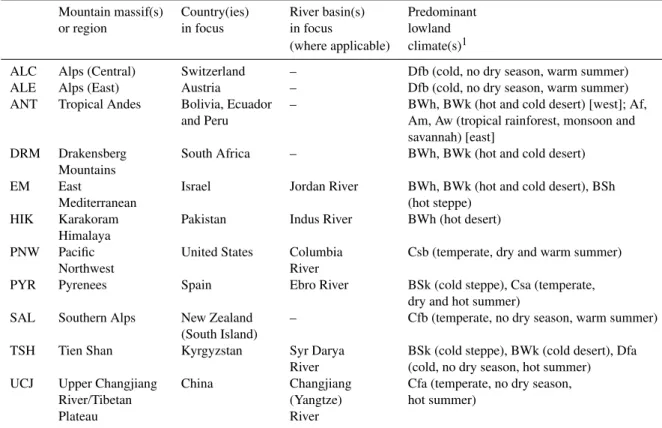
The 11 case-study regions examined as a basis for the fol-lowing discussions are listed in Table 1 along with the corre-sponding countries and river basins (the latter are only listed if there is a single major river basin to focus on). The pre-dominant lowland climates, essential for defining the hy-drological significance of mountain ranges (Viviroli et al., 2007), show a broad range from desert-type climates to cold climates.
Figure 1 shows the location of these case-study regions and places them in the global context of the significance of mountain areas for downstream water resources, which is quantified here by the index for Water Resources Contri-bution (WRC) (Viviroli et al., 2007). WRC is the ratio of lowland water availability (surplus or deficit) to water supply from mountains (only surplus is considered) and identifies the importance of a mountain raster cell for water resources supply in the hydrologically related lowland area.
To allow a comparison of the regions studied with respect to the subject of this overview article, Fig. 2 characterises them on the basis of the metrics mentioned below. Metrics B to D consist of a number of detail questions that were as-sessed by the authors (each for his/her geographic region of expertise). The detail questions and the corresponding scores are found in Table S1 (see Supplement):
– Water stress: dynamic Water Stress Index (DWSI) as introduced by Wada et al. (2011), averaged over cells of 0.5◦×0.5◦. DWSI is based on the well-known
Table 1.Regions studied as a basis for the present article.
Mountain massif(s) Country(ies) River basin(s) Predominant
or region in focus in focus lowland
(where applicable) climate(s)1
ALC Alps (Central) Switzerland – Dfb (cold, no dry season, warm summer)
ALE Alps (East) Austria – Dfb (cold, no dry season, warm summer)
ANT Tropical Andes Bolivia, Ecuador – BWh, BWk (hot and cold desert) [west]; Af, and Peru Am, Aw (tropical rainforest, monsoon and
savannah) [east]
DRM Drakensberg South Africa – BWh, BWk (hot and cold desert) Mountains
EM East Israel Jordan River BWh, BWk (hot and cold desert), BSh
Mediterranean (hot steppe)
HIK Karakoram Pakistan Indus River BWh (hot desert) Himalaya
PNW Pacific United States Columbia Csb (temperate, dry and warm summer)
Northwest River
PYR Pyrenees Spain Ebro River BSk (cold steppe), Csa (temperate, dry and hot summer)
SAL Southern Alps New Zealand – Cfb (temperate, no dry season, warm summer) (South Island)
TSH Tien Shan Kyrgyzstan Syr Darya BSk (cold steppe), BWk (cold desert), Dfa River (cold, no dry season, hot summer) UCJ Upper Changjiang China Changjiang Cfa (temperate, no dry season,
River/Tibetan (Yangtze) hot summer)
Plateau River
1According to the K¨oppen-Geiger climate classification as presented by Peel et al. (2007)
the available water is taken up by the demand. DWSI extends WSI by considering duration, frequency and severity of water stress over a period of 44 years (1958 to 2001), based on climatological data obtained from New et al. (1999). Values above 0.2 indicate medium water stress, and above 0.4 indicate high water stress. The dot indicates the mean value for the entire region (including the lowland portions), and the coloured bars indicate the range of water stress observed in the entire region.
– Water management capacity: capacity of the water man-agement sector to adapt to projected climate change. We judged 14 questions organised in four thematic blocks: institutional capacity; political conditions; manager competence; and knowledge transfer with researchers. For each block, a score of 1 means low capacity, and a score of 5 indicates high capacity. The summary score is the average of the scores achieved in the four thematic blocks. The coloured bars indicate the range of scores observed in the four thematic blocks.
– Scientific capacity – national: scientific capacity in wa-ter resources and climate change available in the respec-tive nation. This is assessed through 11 questions organ-ised in four thematic blocks: boundary conditions for
research; competence in research; data availability and access; and state of knowledge. A score of 1 means low capacity, and a score of 5 indicates high capacity. The coloured bars indicate the range of capacity observed in the four thematic blocks.
– Scientific capacity – international: similar to national scientific capacity (metric C), only that here, the capac-ity available for the respective region at international level is assessed.
The main goal of this assessment is to illustrate the level of diversity in both likely water stress and the capacity to deal with water stress that occurs in our case-study regions, thus providing a framework for more detailed assessments and subsequent recommendations. Also, we refer only to changes related to climate, whereas further aspects such as land use change, economic development and population growth are also important in defining the future state of wa-ter resources.
Fig. 1.Location of our case-study regions on a world map at a resolution of 0.5◦×0.5◦showing the significance of mountain regions for
lowland water resources (following Viviroli et al., 2007).
measures necessary for adaptation are not available due to poor economic development and the resulting lack of funds. An exception to this general trend is found in the Pyrenees (PYR) and the Drakensberg Mountains (DRM) where rela-tively high average water stress is paired by well-developed management capacity. It should be noted that the reported values for water stress refer to the mean of the entire case-study region, which may mask smaller areas with high wa-ter stress. This applies, for example, to Bolivia, Ecuador and Peru which were chosen to represent the Tropical Andes (ANT). The average water stress computed for this region is 0.15, while the arid parts of the region (the Andes them-selves, including the Pacific slopes as well as the lowlands to the west) show values well above 0.4. Similar reservations apply to the average water stress value for the Karakoram Hi-malaya (0.29), especially because the Indus Plains – where the majority of the population lives – suffer from even more severe water stress (Archer et al., 2010), frequently with val-ues well above 0.8. The average value for the Pyrenees (0.22) also masks the fact that stress is much higher in the adjacent River Ebro Plain. These examples illustrate the importance of considering the range indicated by the coloured bars in Fig. 2 and to bear in mind that the level of water stress is very diverse in some regions. The top left of Fig. 2a shows the central and eastern part of the European Alps (ALC and ALE). In these regions there is a very high level of manage-ment capacity and generally low water stress, the latter oc-curring almost exclusively outside of the actual mountainous region.
Part (b) of Fig. 2 assesses the scientific capacity to deal with climate change questions for our case-study regions. It shows that regions with low national scientific capacity usu-ally have slightly higher research capacity at the international level, most notably in the Tropical Andes (ANT) and the Karakoram Himalaya (HIK). In practice, however, interna-tional scientific support will obviously require appropriate
funding which will usually also be of international origin. It is important to note that these factors may be outside the direct control of the region in question. In contrast, where there is high national scientific capacity, international sci-entific capacity usually lags behind, although international projects (such as research funded by the EU in the case of the European Alps, ALC and ALE, and the Pyrenees, PYR) may still make the region attractive for international research and lead to a relatively high level of international scientific capacity. The Upper Changjiang region (UCJ) presents an outlier from the aforementioned connection as it has rela-tively high national scientific capacity but rather poor inter-national capacity. The emerging economic power of China has led to international scientific aid becoming less available as the country is increasingly expected to rely on its own sci-entific resources. The Southern Alps (SAL) represent an-other outlier because New Zealand has very limited access to overarching international research coordination and funding networks.
Fig. 2. Characterisation of the regions studied with regard to
(a)water stress and water management capacity to adapt to climate change;(b)national and international scientific capacity regarding climate change and water resources issues;(c)water management capacity to adapt to climate change and maximum scientific capac-ity (regardless whether of national or international origin) regarding climate change and water resources issues. The coloured bars indi-cate the range of values.
impacts that exceed the existing range of natural variability (Hamlet, 2010). This situation illustrates that limited capac-ity to respond to climate change impacts and institutional ob-stacles to effective adaptation are present even in highly de-veloped and successful management systems. In contrast, a common assumption is that increased water stress in areas that already have a high degree of water stress will result in the most severe impacts. Hamlet (2010), however, points out that management systems in the PNW that have evolved in areas of relatively high water stress are much better able to cope with droughts because they are already common events, suggesting higher adaptive capacity to future water limita-tions than areas of the region with relatively little historical water stress. These findings probably also apply to other ar-eas with high water stress and high water management ca-pacity noted above.
Thus the diversity of settings observed in our cross-section of regions calls for a regionally and sometimes even locally differentiated view to future management. At the same time, the detrimental concurrence of high water stress and low management capacity in regions with poor economic devel-opment seems to be a common problem that urgently calls for improvements in research, monitoring, management and information exchange, topics we address in Chapters 4 and 5 of this article. For more subtle distinctions, several categories would need to be separated, such as access to infrastructure, management capacity in the context of climate variability, ability to assess future impacts and devise appropriate adap-tation strategies or capacity to implement change.
3 State of knowledge
As a basis for identifying research and monitoring needs (Chapter 4) and making recommendations (Chapter 5), we first need to discuss the state of knowledge on provision of runoff from mountains (supply), consumption of water in the lowlands (demand) and options for balancing demand and supply. This will enable us to discuss what kind of infor-mation is needed to answer the questions raised by water resources management and planning and how it can be ob-tained and disseminated.
Due to the large uncertainty concerning groundwater recharge and flows (see Sect. 4.1.5), we will focus on surface water in the following discussion. It is however important to note that groundwater is often heavily used for water sup-ply in both developed and undeveloped countries, although groundwater resources are generally both poorly understood and poorly monitored. This situation leads to an absence of attempts to regulate or manage these resources. Also, the po-tential impacts of climate change (e.g. on rates of recharge) in groundwater systems are often essentially unknown.
provide a comparative overview, although water demand within mountain regions should not be neglected. This is particularly the case in the Andes, where the mountain re-gion forms the economic backbone of several countries (e.g. Colombia, Ecuador and Bolivia). Especially since the hydro-logical processes of these regions are both extremely variable and understudied, there is a strong need for future research on the resilience and potential changes of these systems un-der external pressure (see Buytaert et al., 2010a).
3.1 Water supply (runoff from mountains)
3.1.1 Present state
Viviroli et al. (2007) recently presented a global overview of the role of mountains in water supply. On the basis of global runoff fields (Fekete et al., 2002), a mountain typology (Mey-beck et al., 2001) as well as further data on population distri-bution and climate zones, they derived a set of global maps at a resolution of 0.5◦×0.5◦, revealing that 23% of mountain
areas world-wide are an essential component of downstream water supply in the earth system context, while another 30% have a supportive role. When the actual lowland water use is considered explicitly, 7% of the global mountain area has an essential role in water resources, while another 37% provides important supportive supply (Fig. 1). This is of special im-portance in arid and semiarid regions where the vulnerability to seasonal and regional water shortages is high. Moreover, mountains in the arid zone clearly deliver a disproportion-ate share of total discharge (66.5%) when compared to their share of total area (29.8%). Critically important mountain re-gions are found in the Middle East, South Africa, parts of the Rocky Mountains and the Andes. The importance of moun-tain water resources from the western part of the Himalaya and from the Tibetan Plateau is particularly marked because these regions partly compensate considerable lowland water deficits (Archer et al., 2010).
Snowmelt plays a major role in seasonal runoff patterns and water supply outside of the humid tropics. This was recently shown by Barnett et al. (2005) who used the out-put of a macro-scale hydrological model with a resolution of 0.5◦×0.5◦to assess the ratio of accumulated annual
snow-fall to annual runoff. The authors also compared the sim-ulated annual runoff to the capacity of existing reservoirs, which served to identify cases where sufficient reservoir stor-age capacity is available to buffer seasonal shifts in runoff caused by earlier snowmelt (see also Sect. 3.1.5). In their analysis, Barnett et al. (2005) found that about one-sixth of the world’s population lives within snowmelt-dominated catchments with low reservoir storage, this domain being potentially vulnerable to shifts in runoff caused by climate change impacts on seasonal snow. A critical region, for ex-ample, is the Western Himalaya where a modelling study for the Satluj River basin (a tributary to the Indus River) by Singh and Jain (2003) suggests that about 75% of the sum-mer runoff is generated from snowmelt. On the
neighbour-ing Jhelum River basin, Archer and Fowler (2008) show a similar dependence of summer runoff on preceding winter snowfall. Barnett et al. (2005) have identified further regions with high dependence on snowmelt runoff in northern China, north-western India, sub-basins downstream of the southern Andes, north-central USA, and some coastal areas of West-ern North America and Europe. Adam et al. (2009), how-ever, showed in modelling studies that losses of warm season water availability did not, in general, follow losses of snow water equivalent at the global scale. Thus changes in warm season precipitation are an important factor that needs to be considered in the analysis of projected water availability in many areas.
orographic precipitation mechanisms dominate rather than convective systems (the majority of the Upper Indus falls into this category as there is, in most years, relatively lim-ited monsoon penetration). Nevertheless, the glacial regime plays an important role in the high-altitude catchments of the Indus River, although its influence decreases strongly toward the margins of the mountains (Archer et al., 2010). In con-trast, proportional flow from glaciers over large areas in the tropical Andes is much higher because the area affected by interannual snowpack is limited (see Sect. 3.1.3).
Glaciers may provide a smoothing effect for water re-sources by complementing irregular runoff from highly vari-able summer precipitation with much more stvari-able runoff from melting snow and ice (see e.g. Hock et al., 2005). In effect, glaciers reduce the interannual variability of summer flows by storing water in cold and wet years and releas-ing water in hot and dry years, as was shown in the 2003 European heatwave when the average summer runoff from glacierized basins in Switzerland was still close to the long-term mean while basins of the Swiss Plateau without glaciers delivered only 40% to 60% of long-term summer average runoff (Zappa and Kan, 2007). With reference to studies from the Cascade Mountains (Fountain and Tangborn, 1985) and the Alps (Chen and Ohmura, 1990), Casassa et al. (2009) conclude that a minimum coefficient of variation in summer runoff is reached with a share in glaciated area of about 40%. Due to the low temperatures, permafrost exists in all mountainous areas of sufficient elevation. The largest area of mountain permafrost (approx. 3.5×10⁶km2)is found in the Central Asian region, and permafrost in high Andes amounts to another 100 000 km2 (Romanovsky et al., 2007). In the European Alps, periglacial permafrost currently occupies an area comparable to that of glaciers, but in comparison to alpine glaciers, very little is known about the secular evo-lution of permafrost and the corresponding release of water (Haeberli and Beniston, 1998). The amount of melt water originating from permafrost is very small as compared to the interannual melting of glaciers and snow pack (Tenthorey, 1992) and therefore not relevant for water supply at global and regional scale.
3.1.2 Past trends in mountain runoff
Analysis of runoff trends over the historical record are very difficult for both mountainous and lowland areas. Results de-pend heavily on the methodology implemented and the time-frame of the study (see e.g. Radziejewski and Kundzewicz, 2004), and the high variability of precipitation and tempera-ture often lead to inconclusive or misleading findings. Partic-ular challenges are imposed by interannual and decadal scale variations in precipitation and mountain snowpacks that are caused by large-scale circulation modes such as the El Ni˜no-Southern Oscillation, the Eurasian Pattern, the North Atlantic Oscillation, the North Pacific Oscillation, the Pacific North American Pattern, the Pacific Decadal Oscillation and the
In-dian Monsoon to name but a few. Some studies have statis-tically removed interannual variability due to natural climate modes from time series, attempting to isolate trends from other factors than global warming (Vuille and Milana, 2007), but such approaches add uncertainty to the analysis, and the relatively short time span of most data records (typically a few decades) remains a major impediment to the detection of conclusive trends.
For mountain areas, trend detection is often assumed to be easier due to the high climatic sensitivity of these environ-ments, although concurrent changes in temperature and pre-cipitation as well as the lack of unbiased long-term records (see Sect. 4.2.2) complicate trend studies. Two regions stand out because there is both extensive and sound scientific ev-idence of past trends in mountain runoff as well as a large dependence of the adjacent lowland region on this mountain runoff:
– For the Western United States, a number of studies found that more precipitation is falling as rain instead of snow in winter, and that snow melt occurs earlier (e.g. Hamlet et al., 2005; Mote et al., 2005; Knowles et al., 2006), resulting in systematic changes in runoff timing (Dettinger et al., 1995; Cayan et al., 2001; Re-gonda et al., 2005; Stewart et al., 2005; Hamlet et al., 2007). Barnett et al. (2008) were successful in identi-fying an anthropogenic “fingerprint” by using a multi-variable detection and attribution methodology (see also Hamlet, 2010). Particular difficulties apply however to trend analyses in the mid-elevations of the semi-arid and arid climate zones. In these critical regions, the natu-ral runoff pattern of most of the large streams has been altered, largely by dams or diversions (cf. D¨oll et al., 2009), which makes it difficult to assess changes in the natural response of amount and timing of streamflow (cf. Stewart, 2009).
Evidence for decreasing snow cover and corresponding shifts towards earlier streamflow has also been presented for the Ob, Lena and Yenisei Rivers in Siberia (e.g. Yang et al., 2002, 2003 and 2007), which illustrates the recurrence of global warming impacts on streamflow regimes in snow-dominated regions.
Although changes in temperature and precipitation cer-tainly have the largest impact on streamflow from a global viewpoint, it should be borne in mind that other factors can also effect changes in streamflow in some regions. In Mediterranean mountains such as the Pyrenees, for exam-ple, depopulation and subsequent land abandonment have led to vegetation growth which has been the main driver of ob-served reductions in runoff generation and decreases in an-nual streamflow (Begueria et al., 2003; L´opez-Moreno et al., 2008). Further influence on the evolution of water availabil-ity in the Ebro River basin stems from dam regulation, de-crease in snowpack, inde-crease in evapotranspiration rates and increased water use for domestic, agricultural and industrial use, although these factors are inferior to the impact of vege-tation growth (L´opez-Moreno et al., 2010).
3.1.3 Climate change projections
Scenario projections for the impacts of climate change on precipitation and runoff are subject to large uncertainties at the global scale. This is apparent in comparing the results of different General Circulation Models (GCMs) which show inconsistencies in the sign and magnitude of precipitation change (Bates et al., 2008; Stewart, 2009; see also Buytaert et al., 2009). Climate change scenario projections in moun-tain areas are difficult to construct owing to the difficulties in modelling regions with marked small-scale variations in cli-mate that follow topography (see Sect. 3.1.4 and Chapter 4). Bates et al. (2008) concluded that warming would lead to systematic change in the seasonality of snowmelt-dominated rivers and that snow-dominated regions are particularly sen-sitive to changes in temperature. Depending on elevation and winter temperatures, early snowmelt may lead to more frequent spring flooding at the local scale (Hamlet and Let-tenmaier, 2007), and summer irrigation water shortages may occur in regions that are dominated today by nival regimes (see e.g. Vano et al., 2010). Some studies have argued that large changes are expected especially at low latitudes, e.g. in South-east and Central Asia (Parry et al., 2007). In regions where dependence on glacier runoff is high, shifts in season-ality and decreases in the amount of glacial melt will cause a systematic reduction in water availability as well as a reduced buffering effect of glacier runoff during the dry season (e.g. in the Tropical Andes, see Coudrain et al., 2005 and Vuille et al., 2008, or in Central Asia, see Hagg and Braun, 2005).
In the Andes, it is likely that water stress will become more severe, especially in urban cities at high altitudes (e.g. Bogot´a, Quito, La Paz). Again, GCMs disagree widely on the direction and magnitude of the change in precipitation,
but several of them predict severe decreases in precipitation (Buytaert et al., 2010b; Buytaert et al., 2010c). Even disre-garding the uncertainty in projections, the impact of climate change on water supply is difficult to predict. Glacier-fed river systems will become more seasonal when glaciers dis-appear, although the glacier signal dilutes relatively quickly with basin size (Mark and Seltzer, 2003; Alford and Arm-strong, 2010; see also Sect. 3.1.1). The impact of climate change on other ecosystems that provide water regulation, such as tropical alpine wetlands, is much less known al-though a degradation and loss of regional capacity of these systems is expected (Buytaert et al., 2010b).
Owing to the limited research available at present, pro-jections regarding the future state of glaciers are however uncertain. This was recently shown by the controversy sur-rounding the mistaken IPCC statement that the Himalayan Glaciers could disappear by 2035 at present warming rates (see Bagla, 2009; Cogley et al., 2010; IPCC, 2010; Schier-meier, 2010; see also Sect. 3.1.1). In addition, research con-cerning the future state of glaciers must go beyond focusing on precipitation and surface air temperature and must also consider global incoming shortwave and longwave radiation (Huss et al., 2009) or, in the case of tropical glaciers, atmo-spheric moisture (M¨olg et al., 2006).
Considering the present state and anticipated changes, a number of regions have been identified as particularly vul-nerable to changes in mountain runoff with subsequent dete-rioration of water resources supply in the adjacent lowlands. – Viviroli et al. (2007) identify vulnerable regions where a high dependence on mountain runoff in the lowlands coincides with anticipated decrease in precipitation and growth in population. This applies mainly to river basins in the sub-tropical and wet-dry tropical climate zones where the capacity to adapt to changes is also low. Particularly vulnerable regions encompass great parts of the large Himalayan river basins that are, according to recent population data (ORLN, 2002), home to over 1.3 billion people today, but also the Middle East (e.g. Eu-phrates and Tigris River basins), North, East and South Africa as well as the dry parts of the Andes (in the cen-tre, highlands, and western side of the northern Andes and in the eastern side of the southern Andes).
and Western Australia. The reasons for the vulnerabil-ity of these systems vary strongly from region to region and encompass a number of anticipated changes, such as unfavourable changes in the amount and timing of precipitation and runoff, altered precipitation variabil-ity, groundwater tables, population growth and food de-mand. Similarly diverse are the factors that limit adapt-ability, such as limited capacity to further extend the existing infrastructure, water resources that are already over-allocated or a lack of financial resources to support adaptation.
3.1.4 Representation of mountains in climate and hydrological models
Climatological and hydrological models are important tools for laying the foundations for successful and sustainable wa-ter management. Insight into important processes of moun-tain areas is achieved through process-oriented hydrological modelling exercises with focus on snow and glacier melt. A number of such studies have been conducted for meso-scale catchments in the European Alps (e.g. Gurtz et al., 2003; Ver-bunt et al., 2003; Zappa et al., 2003; Schaefli et al., 2005; Horton et al., 2006; Lehning et al., 2006; Dadic et al., 2008; Huss et al., 2008; Koboltschnig et al., 2008; Michlmayer et al., 2008; Bavay et al., 2009; Lambrecht and Mayer, 2009; Weber et al., 2009; K¨oplin et al., 2010; Magnusson et al., 2010) the Scandinavian mountains (e.g. Hock, 1999; Hock and Holmgren, 2005; Skaugen, 2007; Beldring et al., 2008), the Rocky Mountains (e.g. Hamlet et al., 2005 and 2007; Letsinger and Olyphant, 2007; Stahl et al., 2007; Comeau et al., 2009; DeBeer and Pomeroy, 2009; see also overview by Bales et al., 2006), the Western Himalaya (e.g. Singh and Bengtsson, 2003; Singh and Jain, 2003; Rees and Collins, 2006; Konz et al., 2007; Akhtar et al., 2008) and Central Asia (e.g. Hagg et al., 2007). Global macro-scale studies (e.g. Bar-nett et al., 2005; Adam et al., 2009) are equally important in providing a self-consistent global picture.
Climatological and hydrological modelling is, however, particularly challenging in mountain environments for sev-eral reasons. First, extremely limited meteorological driv-ing data and hydrologic data are available for high elevation areas. Second, the pronounced spatial and temporal hetero-geneity of conditions in mountain areas calls for high model resolutions and thus also for detailed physiographic informa-tion (e.g. soil, vegetainforma-tion and land use types). The latter is usually only available for limited areas, which restricts the availability of reliable modelling efforts mostly to case stud-ies at the meso scale. Third, relevant processes in mountain areas are not understood sufficiently, particularly orographic precipitation and snowfall, which are among the most diffi-cult variables to simulate in climate models. The lack of data hampers the research community’s ability to validate poten-tial improvements in high elevation processes in models.
Another area of uncertainty concerns the magnitude of the feedback effects (see Sect. 4.1.6) and their influence on the energy balance. Due to the limited process understanding, formulation of such effects varies substantially between indi-vidual models. Furthermore, the interaction between climate change and vegetation and its effect on evaporation and the hydrological cycle is also not fully understood (Adam et al., 2009). Altogether, the impact of climate change on the water cycle in mountainous regions – particularly on snow and ice – is highly non-linear and requires much more detailed re-search to help quantify uncertainties in projections related to climate forcing and hydrologic modelling uncertainties. Es-pecially when using macro-scale models, the increasing size of the area studied requires more empirical approaches, lim-iting the level of detail and explicit process representation. Interpretation of results from macro-scale models at smaller spatial scales is therefore problematic, and the sensitivity of hydrologic models to temperature and precipitation forcing may reflect the scale of the implementation.
Aside from the abovementioned challenges, it should also be borne in mind that socio-economic issues have an impact on mountain hydrology and climatology and consequently on water availability, and that it is important to work towards incorporating these effects in our models. Examples are the influence of irrigation, dam construction, drinking water use, tourism and alpine lake management on water availability, the influence of large dam reservoirs on local and regional climatology, or the influence of topography on water distri-bution and use. The relevance of such effects, however, de-pends on the scale and region in focus.
3.1.5 The role of reservoirs
demand (typically the high agricultural demand in spring and summer) and a stabilisation of water supply on an interannual basis. This redistribution of runoff is most effective when im-plemented through long-term basin planning and integrated operation of multiple reservoirs, such as in China.
Since dams can take on a role that is similar to that of the natural storage of water in snow and ice, it is possi-ble in some instances to compensate climate-change induced shifts in runoff regime by building additional dams, increas-ing the size of existincreas-ing reservoirs (raisincreas-ing dam height), or using aquifer storage and recovery schemes to increase stor-age capacity (Whitely Binder et al., 2010). This engineering approach to adaptation, however, faces a number of problems and questions:
– In developing areas, feasible dam sites may exist, but the needed financial resources to build the infrastruc-ture may be lacking. Dams are also often the most costly approach to aligning supply and demand, and entail serious ecosystem impacts (Hamlet, 2010). The economic feasibility of this mitigation strategy is ques-tionable for many regions of the world, owing to the extremely high investment costs of dams and aquifer storage and recovery schemes. In addition, building large dams may require resettlement of a large num-ber of people (about 1.2 million local residents in the case of the Three Gorges Dam at the Changjiang River in China) and flooding of archaeological heritage (such as in case of the Ilisu dam at the Tigris River which would drown the ancient town of Hasankeyf and further archaeological heritage).
– In highly developed areas, most of the good impound-ment sites have usually already been developed, and major expansion of these resources is infeasible. An example is the Columbia River basin which features 14 large storage dams and about 250 major dams in the entire catchment. In the portfolio of adaptation options available to water planners in developed countries, dams are often the most costly approach to aligning supply and demand (Hamlet, 2010).
– Dams are associated with major ecosystem impacts. Al-teration of amount and, even more importantly, vari-ability of river flow causes a number of environmental impacts downstream such as changes in river ecology (boosted through the concurrent fragmentation of rivers, see WWAP, 2009). In addition, the erosive capacity of downstream flows may be increased due to an imbal-anced sediment budget, causing damages to river bank infrastructures (Kondolf, 1998).
– The lifespan of most reservoirs is limited due to sedi-mentation if no attempts for an effective sediment man-agement are undertaken. The problem is exacerbated by
the high bedload transport rates typical in mountain ar-eas. For large reservoirs, sedimentation is usually an ir-reversible process, and the associated reduction of stor-age volumes diminishes the stabilising effect on water supply significantly over the decades (Morris and Fan, 1998).
Artificial aquifer recharge systems avoid the many envi-ronmental impacts of surface water projects, but can result in deteriorated water quality over time if they are not care-fully managed, and recharge rates may not be sustainable over long periods of time.
In many cases, the above concerns have led to public op-position to the construction of new dams, delaying projects considerably and, in extreme cases, even bringing projects to a halt. In Spain, for example, most of the existing plans for building new dams are stalled in the law courts because progress in each of the ongoing or planned hydraulic projects requires open public debate and long stakeholder participa-tion processes (Ib´a˜nez and Prat, 2003). Another example is Pakistan which, in spite of two large dams (Tarbela and Mangla) on the mountain rim, has limited storage in com-parison with world standards (World Bank, 2005). In terms of storage capacity, Pakistan has 150 m3per capita compared with the United States and Australia with over 5000 m3per
capita. Successive attempts to develop major new reservoirs on the Indus have met with strenuous political as well as en-vironmental objections.
Other factors such as changes in patterns of evaporation and evaporation losses, changing outflow requirements (e.g. related to changing instream flow needs, demand for electric-ity, or water supply demands, required flood control space, etc.) as well as minimal discharge requirements for ecology and the environment also need to be considered.
In the context of water engineering and reservoirs, it is also important to bear in mind that long interbasin water transfers become more and more attractive for solving water problems in developing countries with increasing populations and ex-panding economies, such as China and India (Ghassemi and White, 2007). A large-scale example already under construc-tion is the South-to-North water transfer project which will deliver water from the South of China to the water-short North of China by means of three transfer routes. Nega-tive environmental impacts are however expected for both the Changjiang (Yangtze) and Huanghe (Yellow) Rivers (Zhang, 2009). In Europe, the Spanish Parliament had approved of transferring water from the Tagus and the Ebro River basins to Mediterranean areas, but these plans have been brought to a halt through strong social and political opposition (Ib´a˜nez and Prat, 2003). Since such transfers significantly extend the lowland portion of a river catchment, the pressure upon mountain water resources must be expected to increase fur-ther, also raising residual flow issues and associated prob-lems for ecosystems and water quality downstream of diver-sions.
Regarding adaptation to increased flood events, reservoirs located in the mountains can play an important role in re-taining flood peak volumes. For this purpose, sophisticated flood forecasting and management systems are required. In the upper part of the River Rhone in Switzerland, for exam-ple, the System MINERVE (Mod´elisation des Intemp´eries de Nature Extrˆeme dans le Rhˆone Valaisan et de leurs Ef-fets) has been developed (Jordan et al., 2005; Garc´ıa Her-nandez et al., 2009). MINERVE makes use of a combined multipurpose system of reservoirs for hydropower produc-tion and flood prevenproduc-tion. During times of drought (which may occur more frequently in future), the multipurpose char-acter of these reservoirs is already made use of nowadays in that water from reservoirs is used for irrigation in summer or for artificial snow making in tourist resorts in winter. A formal convention between the responsible public authori-ties and the owners of the reservoir is a prerequisite for the successful operation of such a system.
3.2 Water demand (consumption in lowlands)
When considering water resource questions, we must also consider water demand. As demand is largely outside of mountain regions, a detailed investigation of future demand is beyond the scope of this paper, and is in any event sub-jected to an even greater number of uncertainties due to pop-ulation and technology than are supply projections.
3.2.1 Agriculture
According to the UN WWDR3 (WWAP, 2009), roughly 70% of global water withdrawals are used for irrigated agricul-ture today. Therefore, fuagricul-ture water demand for food produc-tion will potentially have the biggest impact on overall water demand.
A critical mountain-related issue is that large scale stud-ies at the regional scale do not sufficiently account for the seasonality of agricultural demand and water availability. A number of national and global studies continue to use an-nual water supplies as the key metric for potential impacts. In critical regions with limited storage, however, vulnerabil-ity to water stress will increase markedly if seasonalvulnerabil-ity of mountain runoff changes so that alignment of supply and de-mand is disrupted. Agriculture is especially vulnerable be-cause it benefits from spring and summer runoff from moun-tains at the time when water demand to support plant growth is largest.
Three factors are decisive in this context. First, population dynamics and economic development will alter the patterns of regional demand, with strong increases expected in down-stream regions that already today exhibit high demand. The growing demand in all water use sectors caused by popula-tion and development pressure is projected to exceed even changes induced by climate change in some regions (see also V¨or¨osmarty, 2000), including areas like the Middle East or South Asia which benefit today from mountain runoff (Vivi-roli et al., 2007; Archer et al., 2010). Second, dietary habits might also have considerable influence, especially the trend towards higher shares in meat consumption which means that more water is required to produce the same calorific value. According to Molden (2007), global average meat consump-tion will rise from 37 kg per capita per year in 2000 to 48 kg in 2050. A particularly strong increase is expected in East Asia where economic growth will boost annual meat con-sumption to the level of OECD (Organization for Economic Co-operation and Development) member countries. This is equivalent to an almost twofold increase between 2000 and 2050. Third, rising temperatures will potentially increase evaporative demand and thus might reduce crop yields, such as anticipated for the Lower Indus plains where projections suggest a reduction of wheat yields in most climatic zones (Sultana et al., 2009), although this reduction might be partly compensated by the direct enhancing effect of increasing CO2on crop yields.
farmers to agricultural policy (e.g. subsidies for certain farm-ing schemes or certain regions) or energy policy (e.g. subsi-dies for biofuels).
It is also important to note that impacts to food security are not only related to water. In the subtropics, for example, re-cent studies have shown that temperature impacts alone may result in massive reductions in yield from stable crops (Bat-tisti and Naylor, 2009). Thus certain impacts may be com-pletely disconnected from water supply impacts related to mountain processes. Similar arguments related to impacts from low-elevation precipitation change and dryland agricul-ture are pertinent in that impacts in mountain environments may not constitute the dominant impact pathway.
3.2.2 Hydropower
Although hydropower does not represent a consumptive wa-ter use, it affects runoff seasonality in the case of reservoir storage and, moreover, creates considerable challenges for water resources management in terms of reservoir operation for water allocation and risk management. The construction of a large number of additional dams is anticipated with eco-nomic development and the associated increase in energy de-mand. A further incentive for building dams stems from the low CO2emissions associated with hydropower: In its World
Energy Outlook 2008, International Energy Agency (IEA, 2008) draws a scenario with more than doubling of current hydropower capacity until 2030 to meet climate goals.
Vast unused potential for hydropower production is present in Africa, developing Asia, Latin America, China, India and Russia (IEA, 2006). In the Yalong River, a branch of the Changjiang River’s mountainous upstream area, for example, plans foresee construction of 21 new reservoirs during the next 15 years. Moreover, use of air condition-ing may become more widespread and frequent in industri-alised countries, owing to the rising air temperatures. The resulting increase in summer energy demand may pose prob-lems in regions where no or insufficient reservoir volumes are available, especially when summer runoff is decreasing at the same time (e.g. in the Pacific Northwest of the United States, Hamlet, 2010).
In a number of developing and developed countries, en-ergy demand and supply are becoming increasingly mis-aligned, and the development of local hydropower resources is frequently viewed as the only economically secure and sus-tainable pathway to future energy development. In Chile, for example, recent national energy policy has proposed the con-struction of a number of large hydropower dams in Patago-nia to meet projected increases in energy demand. Perspec-tives in areas where hydropower development has been ma-ture for many years can be fundamentally different. In the Columbia River basin, for example, attempts to mitigate im-pacts to ecosystems have historically become an increasingly important issue in the decades following hydropower devel-opment (Hamlet, 2010). Current water resources
develop-ment in China (e.g. the Three Gorges project) and Southeast Asia (e.g. development of the Mekong River) show many similarities to the underlying values towards water resources development that were present in the USA in the 1950s and 1960s. It remains to be seen, however, if social values in these rapidly developing countries will follow a similar tra-jectory to those encountered in the USA in the decades fol-lowing development.
3.3 Balancing demand and supply
There are apparent theoretical limits to the fraction of an-nual flow that can be extracted from a particular water sup-ply system. Lettenmaier and Burges (1977), for example, showed that attempts to extract more than about 0.7 times an-nual flow would generally result in poor performance of the water supply system, and that increasing storage would not successfully mitigate these impacts. These findings support the argument that overallocation of water supply systems is a crucial sustainability issue. In the context of climate change, reductions in annual flow in mountain areas with decreasing precipitation are therefore also a concern, even if demand in the lowlands were not projected to increase significantly.
Already today, there are extended regions that are expe-riencing water stress and, at the same time, depend at least to some degree on mountain water resources. Examples are found in the Southwest USA (associated mountain range: Rocky Mountains), the Pacific side of the Tropical Andes, South Africa (Drakensberg Mountains), parts of the Mediter-ranean (e.g. Atlas Mountains and Pyrenees), the Middle East (Anti-Lebanon Mountains), large parts of Asia (e.g. Hi-malayas) and Southeast Australia (Snowy Mountains) (see WWAP, 2009). In all of these cases, solutions are urgently required to prevent the detrimental consequences of water stress. One approach to adaptation in this context is water resources management that orients itself not solely by water demand but also by the limits of the supply and thereby con-siders all of the decisive factors across the entire river basin. In regions where such multi-objective planning is the norm, the ability to encompass changes in the constituents of the current management plans is a potential obstacle to success-ful adaptation (Hamlet, 2010).
limit food distribution (cf. Meek and Meek, 2009). On the other hand, export of virtual water from dry and mountain-fed regions such as the Mediterranean, South America and Asia should be reassessed very critically. In some regions, it might however be possible to reduce water stress by im-proving water quality. In the Andes, for instance, significant economic activity takes place at high altitude, including very polluting industries such as mining. These areas are head-waters of large river systems that are intensively sourced in the drier coastal areas. Combined with a lack of local regula-tion, pollution of these rivers may make them unsuitable for extraction or pose health risks.
From the present point of view, the most promising op-tion to re-balance supply and demand seems to be reduc-ing demand (see Molden, 2007) which, as opposed to im-provements in infrastructure in order to increase water sup-ply, is generally much cheaper and avoids associated un-desirable indirect effects such as ecosystem disruption and loss of arable land. For regions with low or medium eco-nomic development and high dependence on irrigated agri-culture, reducing demand may be achieved by implementing more efficient water-saving irrigation techniques. For Pak-istan, for example, the World Bank (2005) notes the “hope-ful fact” that there is much scope for increasing produc-tivity given the low crop yields (e.g. wheat yield per unit of water in Pakistan is 50% of that in the Colorado River Basin). Where economic development is already high, reduc-tion of demand can be achieved relatively easily by techno-logical advances that improve irrigation efficiency (see e.g. FAO, 2002), reuse of treated waste water, regulatory ap-proaches (e.g. prohibit irrigation of certain crops and exces-sive private water use during drought periods) and general conservation measures (e.g. campaigns for reduced house-hold water use). It should however be borne in mind that population dynamics and economic development will sig-nificantly increase water demand in some regions (see e.g. Lins and Stakhiv, 1998; Koutsoyiannis et al., 2009), such as the Middle East (Bou-Zeid and El-Fadel, 2002) or the densely populated catchments that originate in the Hindu Kush-Karakoram-Himalaya (WWAP, 2009).
4 Research and monitoring needs
In identifying research needs with a view to water resources management, we should prioritise issues that have the high-est potential for improving runoff projections. In our view, the highest priority is to improve projections of all types of precipitation, not only regarding amounts, but also spatial distribution, resolution and temporal variability. Consider-ing that the GCMs represented in the IPCC AR4 are not even able to provide certainty about the sign of projected changes in many regions, problems with all other components of the hydrological cycle are likely to be dwarfed by these uncer-tainties. Further issues of relevance concern better estimation
of snow water equivalent, more detailed data on soil prop-erties and better monitoring and modelling of evapotranspi-ration. In the regions that were studied as a basis for this article (see Sect. 2), aforementioned priority ranking is al-most universal, with only a few minor differences that apply to the relative position of the lower priorities. These and a few more research priorities in process knowledge will be discussed below.
4.1 Research priorities
4.1.1 Improving precipitation projections
Thinking about improvements in precipitation projections quickly brings us to climatological downscaling and its par-ticular advantages in mountainous regions where the accurate representation of spatio-temporal variability of precipitation is a huge challenge. GCMs are run at a very coarse resolution (∼300 km×300 km grid cells) and are therefore not able to reproduce high-resolution features and mountain-specific ef-fects like orographic forcing and rain-shadowing. To model such mountain-induced circulation patterns it is necessary to run limited-area models or to dynamically downscale GCMs using Regional Climate Models (RCMs). Since running RCMs is extremely computationally intensive, however, sta-tistical downscaling (SD) is frequently used as an alterna-tive. Statistical downscaling normally fits an empirical rela-tionship between local observations and regional climate fea-tures (e.g. circulation patterns, pressure fields etc.) using his-toric data and then assumes that this relationship can be used to estimate future changes in local climate from the same regional features modelled using global or regional climate models. Although the results of SD are not based on phys-ical process modelling, they often provide equally reliable results (Fowler et al., 2007). SD has, for instance, great po-tential in the Andes where temporal precipitation variability is highly correlated with large-scale upper air flow which can be adequately simulated in GCMs (Garreaud et al., 2003). Finding the most appropriate downscaling method is not al-ways straightforward, and the choice depends on the tempo-ral and spatial scale in focus. It should however be borne in mind that the choice of the driving GCM generally introduces the largest uncertainty and, together with the choice of emis-sion scenario, is even more decisive for the results than the downscaling method used (Fowler et al., 2007). Therefore, a probabilistic approach should be pursued, using multi-model ensembles of GCMs and downscaling methods to allow the largest uncertainties in future projections of climate change to be explored adequately.
the runoff seasonality is controlled by snow and ice melt and, hence, predominantly by air temperature. However, since much of the summer runoff is provided by the melting of the previous winter snowfall, reliable projections are required for both air temperature and the temporal and spatial distribution of precipitation for assessing the future behaviour of glaciers and their role in providing meltwater during summer months. For example, it has recently been suggested that glaciers in the Karakoram are showing a tendency of mass increase that is in opposition to the trend of rapidly retreating glaciers in the Himalaya (Hewitt, 2005). This may have been caused by a general increase in winter precipitation (as snow) at the confluence of the Westerlies and the southwest Asian Mon-soon (Archer and Fowler, 2004). In spite of rising tempera-tures, altitudes that are still located above the snowline may receive more winter snowfall, leading to glacier mass accu-mulation (Bishop et al., 2008). Alternatively, mass increase may be a result of lower summer temperatures related to in-creased cloudiness, reducing the amount of melt from snow and ice and reducing the concurrent summer flow in the high tributaries of the Indus (Fowler and Archer, 2006).
Overall, much research on downscaling is still needed for the Tropics and the developing world. These regions have been rather neglected despite the importance of more reli-able information on climate risk for development and adap-tation planning where economic growth is already severely hampered by climate variability and change (Fowler and Wilby, 2007). Research should also continue beyond ex-amining downscaling in the context of climate change to as-sess the impacts on hydrology and provide advice for stake-holders and managers for dealing with water adaptation to climate change (Fowler and Wilby, 2007). Following Kout-soyiannis et al. (2009), we argue that the uncertainties related to predicting the future availability of water resources re-quires a more intensive dialogue between climatologists and hydrologists.
4.1.2 Snow water equivalent
Seasonal snow has a considerable effect on the water bal-ance of many rivers (cf. Barnett et al., 2005; Adam et al., 2009). To date, however, the snowpack is represented only in strongly simplified manner in macro-scale hydrological models (Wid´en-Nilsson et al., 2009), and more detailed rep-resentations are restricted to specialised models that operate at the local scale (e.g. Lehning et al., 2006). Snow-covered area is usually accounted for by either modelling the snow-pack, such as in the popular HBV (Hydrologiska Byr˚ans Vat-tenbalansavdelning) model (Bergstr¨om, 1976) or using ob-servations of snow-cover, as applied in the Snowmelt-Runoff Modell (SRM) by Martinec (1975). The main strategies for estimating snowmelt rates include either using concep-tual and relatively simple temperature-index models or more physically-based and complex energy-balance models; the
latter benefit from more accurate process descriptions but in turn require far more detailed data (Ferguson, 1999), espe-cially when forest areas are concerned (Rutter at al., 2009). An exhaustive overview of snowmelt runoff modelling is available from DeWalle and Rango (2008).
For better estimation of possible future shifts in runoff seasonality, more reliable estimates of Snow Water Equiv-alent (SWE) and its spatial distribution are required as a ba-sis for improving our models or at least for calibrating the snow sub-model more rigorously. This improvement mainly calls for better observation techniques and a widespread use of them in monitoring. Besides ground-based point samples (e.g. from snow pillows), space and airborne estimates are of particular interest because they are more representative of an area:
– The advanced passive microwave scanning radiometer on board of the National Aeronautics and Space Ad-ministration (NASA) Earth Observing System (EOS) Aqua satellite currently provides global spaceborne es-timates of SWE. The scattering effects of snow cover are related empirically to snow-cover depth and water content based upon field measurements. Daily, 5 day maximum and monthly mean SWE estimates are avail-able at a spatial resolution of 25 km from 19 June 2002 to the present. Sources of error include variations in snow crystal size, wet snow discrimination and snow mapping in densely forested areas (NASA, 2006), and the accuracy of snow detection in mountainous ter-rain is still limited by the relatively coarse spatial res-olution (Lemke et al., 2007). More detailed SWE data might be retrieved from the COld REgions Hy-drology High-resolution Observatory (CoReH2O). The observatory is a candidate mission for the European Space Agency (ESA) Earth Explorer Programme due for launch in the first half of the present decade (ESA, 2008). CoReH2O utilises twin frequency Synthetic Aperture Radars (SARs) with an emphasis on, among other things, parameterisation of snow and ice processes as represented in hydrological and numerical weather forecasting models as well as climate research applica-tions and validation of hydrological and coupled land-atmosphere models (Rott et al., 2008).
above the ground. The NOHRSC uses SWE data from these surveys operationally, for example, for issuing wa-ter supply and flood forecasts.
A comprehensive overview of snow measurement techniques and the associated problems has recently been presented by Lundberg et al. (2010). For measurement of SWE, the au-thors mention snow pillows and pressure sensors as suitable direct techniques and highlight active gamma radiation atten-uation, cosmic radiation attenuation and ground-penetrating radar as well-suited indirect techniques, although the latter are dependent on direct measurements for validation.
The effort of SWE estimation can be reduced considerably if snow depth is used as a surrogate. This method requires a reliable model for snow density, such as that proposed re-cently by Jonas et al. (2009) for the Swiss Alps as a function of season, snow depth, site altitude, and site location. The de-velopment of such a model requires extensive series of mea-sured snow densities and snow depths: Jonas et al. (2009) used more than 11 000 such measurements, taken at 37 sites over the past 50 years. The snow depth data necessary for ap-plying such a method, in turn, could even be measured with inexpensive temperature sensors (Reusser and Zehe, 2010).
Snow distribution, in contrast, can already be estimated now from remote sensing. In addition, advanced image pro-cessing algorithms are available to estimate the fraction of snow cover within individual pixels (Foppa et al., 2007), which helps to characterise better the discontinuous and het-erogeneous distribution of snow cover in mountainous re-gions. The marked topography of mountain areas, how-ever, introduces additional challenges to remote sensing such as aspect-dependent illumination and reflectance differences, topographic shadowing, geometric distortion as well a more pronounced lack of ground control data, and challenges com-mon to remote sensing in all environments (e.g. haze and clouds) persist (Weiss and Walsh, 2009).
4.1.3 Soil parameters
The lack of relevant soil parameters at an adequate resolu-tion is a universal problem in hydrological modelling. In-formation on soil depth, porosity, wilting point, field capac-ity and hydraulic conductivcapac-ity is frequently used to param-eterise conceptual models, and insufficient accuracy of this information results in increased uncertainty. Soil properties are usually mapped poorly and at a coarse resolution only, and there will likely be no major improvement in the near future, owing to the high cost and low scientific recognition of extensive field campaigns. The problem is amplified in mountain regions with their high heterogeneity of conditions for pedogenesis. Further development and implementation is also required in interpretation of existing soil maps with view to hydrological processes (e.g. dominant runoff processes, see Schmocker-Fackel et al., 2007). Hydrological and cli-matological modelling would also draw great benefit from
improved, coordinated and more extensive in situ soil mois-ture observations that could be used, among other things, for verifying the models’ soil modules. At the global scale, the ESA Soil Moisture and Ocean Salinity Mission (SMOS) has great potential for providing comprehensive data. SMOS, launched in November 2009 and operational since May 2010, operates at the L-band and is designed to provide a global im-age of surface soil moisture every three days, at a resolution of 35 to 50 km and with a penetration depth of 3 to 5 cm (Kerr et al., 2000; ESA, 2009).
The situation is a little better for land cover which can be derived with reasonable accuracy and effort from remote sensing information. Aerial photography, which provides better data at present, is very costly.
4.1.4 Evapotranspiration and sublimation
Considerable difficulties apply to evapotranspiration (ET) and its behaviour under a changing climate. On the one hand, observed values of ET are usually very scarce, espe-cially in dry climates where direct measurements are also quite difficult. On the other hand, the present state of ET is not necessarily meaningful for the future since changes in processes could exert significant influence. The suppres-sion of plant transpiration due to reduced stomatal aperture with increasing CO2 levels (see e.g. Gedney et al., 2006a;
Betts et al., 2007) could, for example, counteract the general trend for higher potential ET at the global level. On the basis of in situ measurements for deciduous trees, Leuzinger and K¨orner (2007 and 2010) found that reduced stomatal conduc-tance under elevated CO2results in a decrease of annual ET
of up to 10% and hence an increase in soil moisture, provided that all other factors remain constant. Modelling a series of more than 100 years, the authors also found that the asso-ciated increase in runoff will be very small (<3%, probably even smaller for other ecosystems and larger catchments) and that the key driver of this increased runoff was the day-to-day rainfall pattern. Grassland on Calcare and on high alpine stands shows a reduction of ET with elevated CO2 by 3 to
7%, depending on grassland type (Stocker et al., 1997; In-auen et al., 2010). For coniferous trees, in contrast, similar effects have not been observed.
the subalpine belt (L´opez-Moreno et al., 2008). In regions where shrub and forest growth are dominant, the impact of increased ET may even outweigh other climate-change re-lated effects.
While sublimation can be an important process to con-sider in most snow- or glacier-covered mountain regions (e.g. Hood et al., 1999), it is especially relevant in arid and semi-arid mountain regions such as the subtropical Andes or the High Atlas where climates characterised by low humidity and high wind speeds combine to produce high sublimation rates (e.g. Ginot et al., 2001; Schulz and de Jong, 2004). Re-duced cloudiness and the resulting negative long-wave radi-ation balance, in conjunction with weak vertical air tempera-ture gradients and a large vapour pressure gradient generally result in enhanced sublimation (Wagnon et al., 1999a, b and 2001; Kaser et al., 2005; Sicart et al., 2005). Since sublima-tion is 8.5 times less energy efficient than melting, high sub-limation rates lead to an overall reduction in mass turnover (reduced melt rates) and hence result in lower river runoff from glaciated or snow-covered catchments. In fact studies in the tropical and subtropical Andes have documented that the enhanced runoff observed in glaciated catchments during the wet season is not the result of an increased energy in-put, which remains quite constant throughout the year, but is caused by the seasonally varying partitioning of the available energy into melt and sublimation (Wagnon et al., 1999a). Es-timates of total sublimation rates vary but range up to 44% of total snow ablation in the High Atlas (Schulz and de Jong, 2004) while studies in the arid Andes have shown that more than 50% of total annual snowfall is subsequently removed by sublimation (Ginot et al., 2006). How sublimation will affect river discharge in these catchments in climate change scenarios is an open question, but given that glacier extent and the seasonal extent and duration of snow cover will de-crease in a warmer environment, the overall impact of subli-mation on freshwater resources will likely become less rele-vant in the future (see Corripio et al., 2007).
4.1.5 Groundwater
Groundwater recharge at the mountain front can be important for replenishment of aquifers (Manning and Solomon, 2005), and is even its predominant source in many basins in arid and semiarid climates (Wilson and Guan, 2004). Recharge of the Atacama Desert aquifer, for example, has been shown to be fed mainly from rainfall and snowfall in the high An-des (e.g. Houston et al., 2002), and D¨oll (2009) found that human vulnerability to a climate change induced decrease of renewable groundwater resources is very high for the cen-tral Andes. Groundwater in the lower Indus plains is sig-nificantly recharged by leakage from irrigation canals fed from the Indus River and therefore also dependent on moun-tain sources (Archer et al, 2010). It should also be borne in mind that anticipated reductions in summer low flows in snow-dominated basins (see Sect. 3.1.3) and increasing
pre-cipitation variability may lead to an increase in demand for groundwater to compensate for changes in availability of sur-face water (Kundzewicz et al., 2007).
To provide a better overall picture, it is crucial to im-prove process knowledge about groundwater flows or at least quantitative data about the extent and renewal rate of large aquifers. Detailed knowledge that is missing today concerns groundwater interaction with surface water as well as the de-pendence of groundwater on natural vegetation, land man-agement and abstraction. This also concerns mechanisms, influences and rates of recharge at the mountain front. A better understanding of the relevant processes such as parti-tioning of water between interflow and deep percolation and flow paths through mountain blocks (see Wilson and Guan, 2004 for details) would help to improve assessment of cli-mate and land use change impacts on groundwater quantity and quality (see e.g. D¨oll, 2009; Goderniaux et al., 2009; Kundzewicz and D¨oll, 2009), and it might also be an impor-tant step towards exploring active management of groundwa-ter resources (such as artificial groundwagroundwa-ter recharge). The improvements in understanding necessary also concern the space-time distribution of mountain precipitation and ET al-ready discussed in Sects. 4.1.1 and 4.1.4.
4.1.6 Enhanced warming and feedback mechanisms
We conclude our presentation of research priorities with re-marks on the enhanced warming that is assumed for high el-evations as a consequence of energy budget and related feed-back mechanisms in mountain areas. The issue of enhanced warming is vital for determining speed and extent of poten-tial changes in seasonal to multidecadal water storage in the form of snow and ice (Messerli et al., 2004).
There are two relevant feedback mechanisms. First, deple-tion of snow- and ice-covered areas reduces surface albedo and thus leads to an increased absorption of short-wave radia-tion. Owing to its close connection to the seasonal snowpack, this effect is strongest in winter and spring of the mid lati-tudes (Giorgi et al., 1997) and has considerable influence on temperature trends in mid elevations that are located near the annual 0◦C isotherm (Pepin and Lundquist, 2008). Second,
decreasing cloud cover at high elevations increases incom-ing solar radiation, formincom-ing a cloud-radiation feedback cy-cle. This feedback was discussed for the Tibetan Plateau by Duan and Wu (2006) and Liu et al. (2009) and is also likely to have occurred in the European Alps (Auer et al., 2007). In addition to these feedbacks, mountains are more directly ex-posed to the middle troposphere where the enhanced hydro-logic cycle will augment the release of latent heat, leading to enhanced warming in high mountain regions, primarily in the tropical latitudes (Bradley et al., 2004 and 2006).