www.atmos-meas-tech.net/9/5965/2016/ doi:10.5194/amt-9-5965-2016
© Author(s) 2016. CC Attribution 3.0 License.
Tropospheric delay parameters from numerical weather models for
multi-GNSS precise positioning
Cuixian Lu1, Florian Zus1, Maorong Ge1, Robert Heinkelmann1, Galina Dick1, Jens Wickert1,2, and Harald Schuh1,2
1German Research Centre for Geosciences GFZ, Telegrafenberg, 14473 Potsdam, Germany
2Technische Universität Berlin, Institute of Geodesy and Geoinformation Science, 10623 Berlin, Germany
Correspondence to:Cuixian Lu ([email protected])
Received: 23 May 2016 – Published in Atmos. Meas. Tech. Discuss.: 16 June 2016
Revised: 17 November 2016 – Accepted: 24 November 2016 – Published: 13 December 2016
Abstract.The recent dramatic development of multi-GNSS (Global Navigation Satellite System) constellations brings great opportunities and potential for more enhanced precise positioning, navigation, timing, and other applications. Sig-nificant improvement on positioning accuracy, reliability, as well as convergence time with the multi-GNSS fusion can be observed in comparison with the single-system process-ing like GPS (Global Positionprocess-ing System). In this study, we develop a numerical weather model (NWM)-constrained precise point positioning (PPP) processing system to im-prove the multi-GNSS precise positioning. Tropospheric de-lay parameters which are derived from the European Cen-tre for Medium-Range Weather Forecasts (ECMWF) analy-sis are applied to the multi-GNSS PPP, a combination of four systems: GPS, GLONASS, Galileo, and BeiDou. Observa-tions from staObserva-tions of the IGS (International GNSS Service) Multi-GNSS Experiments (MGEX) network are processed, with both the standard multi-GNSS PPP and the developed NWM-constrained multi-GNSS PPP processing. The high quality and accuracy of the tropospheric delay parameters derived from ECMWF are demonstrated through compar-ison and validation with the IGS final tropospheric delay products. Compared to the standard PPP solution, the con-vergence time is shortened by 20.0, 32.0, and 25.0 % for the north, east, and vertical components, respectively, with the NWM-constrained PPP solution. The positioning accu-racy also benefits from the NWM-constrained PPP solution, which was improved by 2.5, 12.1, and 18.7 % for the north, east, and vertical components, respectively.
1 Introduction
The world of satellite navigation is going through dramatic changes and is stepping onto a stage of multi-constellation GNSS (Global Navigation Satellite System) (Montenbruck et al., 2014). Not only is GPS of full capability and under con-tinuous modernization, but also GLONASS has finished the revitalization and is now fully operational. Besides, two new constellations, Galileo and BeiDou, have recently emerged. The European Galileo currently comprises 12 satellites de-ployed in orbit and it is working towards a fully operational stage. The Chinese BeiDou officially launched a continu-ous positioning, navigation, and timing (PNT) service cov-ering the whole Asia Pacific region at the end of 2012. It is continuously developing to a global system in the near fu-ture. In addition, the Japanese Quasi-Zenith Satellite System (QZSS) and the Indian Regional Navigation Satellite Sys-tem (IRNSS) are also growing, with one and five satellites currently (as of 2016) operating in orbit, respectively. So far, more than 80 navigation satellites can be in view and transmit data benefitting from the multi-constellation GNSS, which brings great opportunities for more precise positioning, navi-gation, timing, remote sensing, and other applications (Ge et al., 2012).
Undoubtedly, the integration of all existing navigation satellite systems could provide more observations and could thus enable definite improvements on reliability, positioning accuracy, and convergence time of PPP in comparison with the stand-alone GPS PPP. Li et al. (2015a) developed a four-system (GPS+GLONASS+Galileo+BeiDou) position-ing model to fully exploit all available observables from dif-ferent GNSS. They demonstrated that the fusion of multi-ple GNSS showed a significant effect on shortening the con-vergence time and improving the positioning accuracy when compared to single-system PPP solutions. The benefits of the four-system model were also found when applied for real-time precise positioning (Li et al., 2015b), where a reduc-tion of the convergence time by about 70 % and an improve-ment of the positioning accuracy by about 25 % with respect to the GPS-only processing were illustrated. The fusion of multi-GNSS constellations has developed to be one of the hot topics within the GNSS community, not only limited to precise positioning but also for related applications. For ex-ample, the multi-GNSS PPP exhibits significant advantages for GNSS meteorology applications, such as the real-time re-trieval of atmospheric parameters including integrated water vapor, tropospheric delays, and horizontal gradients, in par-ticular for the high-temporal resolution tropospheric gradi-ents (Li et al., 2015c; Lu et al., 2016). Therefore, improving the performance of multi-GNSS precise positioning concern-ing both positionconcern-ing accuracy and solution convergence is the main focus of our study.
Numerical weather models (NWMs) are able to provide the required information for describing the neutral atmo-sphere, from which the meteorological parameters can be derived at any location and at any time by applying inter-polation, within the area and time window considered by
the model (Pany et al., 2001). In the past, the application of NWM in space geodetic analysis mainly focused on the determination of mapping functions (Niell, 1996; Boehm et al., 2006). With respect to the improvements in spatiotempo-ral resolutions as well as in precision and accuracy of the NWM during recent years, tropospheric delay parameters, such as zenith total delay (ZTD), slant total delays, and tro-pospheric gradients, derived from the NWM could satisfy the accuracy requirements for most GNSS applications (Andrei and Chen, 2008). Data from the NWM have been used to perform tropospheric delay modeling or correct for the neu-tral atmospheric effects in GNSS data processing. Hobiger et al. (2008a) made use of ray-traced slant total delays derived from a regional NWM for GPS PPP within the area of eastern Asia. They demonstrated an improvement of station coordi-nate repeatability by using this strategy in comparison to the standard PPP approach where the tropospheric delays were estimated as unknown parameters. Furthermore, an enhanced algorithm for extracting the ray-traced tropospheric delays of higher accuracy from the NWM in real-time mode was pro-posed by Hobiger et al. (2008b). The authors presented the potential and the feasibility of applying the NWM-derived tropospheric delay corrections into real-time PPP process-ing. Besides, Ibrahim and El-Rabbany (2011) evaluated the performance of implementing tropospheric corrections from the NOAA (National Oceanic and Atmospheric Administra-tion) Tropospheric Signal Delay Model (NOAATrop) into GPS PPP. They pointed out an improvement of convergence time by about 1, 10, and 15 % for the latitude, longitude, and height components, respectively, by using the NOAA tropo-sphere model when compared to the results achieved with the previously used Hopfield model.
In this study, we develop a NWM-constrained PPP pro-cessing method to improve the multi-GNSS (a combina-tion of four systems: GPS, GLONASS, Galileo, and Bei-Dou) precise positioning. Tropospheric delay parameters, which are derived from the European Centre for Medium-Range Weather Forecasts (ECMWF, http://www.ecmwf.int/) analysis, are applied to multi-GNSS PPP. Observations from the IGS (International GNSS Service) Multi-GNSS Experiments (MGEX) network are processed. The qual-ity of tropospheric delay parameters retrieved from the ECMWF analysis is assessed by comparison with the IGS final tropospheric delay products (ftp://cddis.gsfc.nasa.gov/ gnss/products/troposphere/zpd/). The performance of multi-GNSS PPP making use of the NWM-derived tropospheric delay parameters is evaluated in terms of both convergence time and positioning accuracy.
delay parameters from ECMWF with respect to the IGS fi-nal tropospheric delay products. In Sect. 3, the positioning results, in terms of the convergence time and the positioning accuracy, achieved with the NWM-constrained multi-GNSS PPP solution are illustrated in comparison to the ones with the standard PPP solution. The conclusions and discussions are presented in Sect. 4.
2 Data collection and processing 2.1 Multi-GNSS data collection
In response to the dramatic development of the global satel-lite navigation world along with the upcoming systems and signals, the IGS initialized the MGEX campaign to enable a multi-GNSS service of tracking, collecting, and analyzing data of all available signals from GPS, GLONASS, BeiDou, Galileo, QZSS, and any other space-based augmentation sys-tem (SBAS) of interest (Montenbruck et al., 2014). Accord-ingly, a new worldwide network of multi-GNSS monitoring stations under the framework of the MGEX project has been deployed in the past 2 years in parallel with the IGS network, which only serves for GPS and GLONASS. Currently, the MGEX network consists of more than 120 stations, which are globally distributed and provide excellent capability of multi-GNSS constellation tracking and data delivering ow-ing to the contributions from about 27 agencies, universities, and other institutions of 16 countries (http://igs.org/mgex). Besides the tracking of the GPS constellation, the majority of the MGEX stations offer the GLONASS data. At least one of the new BeiDou, Galileo, or QZSS constellations can be tracked for each MGEX station. Today, about 75 stations are capable of tracking the Galileo satellites, 80 stations are tracking the GLONASS satellites, and the BeiDou constella-tion is supported by more than 30 receivers. Figure 1 shows the geographical distribution of the MGEX stations and their supported constellations, except GPS, which can be tracked by each station.
2.2 NWM data collection
The pressure, temperature, and specific humidity fields of the ECMWF operational analysis are utilized to retrieve the tro-pospheric delay parameters. The ECMWF data are available at the German Research Centre for Geosciences (GFZ) with a horizontal resolution of 1◦×1◦on 137 vertical model
lev-els extending from the Earth’s surface to about 80 km. We use the ray-trace algorithm proposed by Zus et al. (2014) and compute station-specific zenith hydrostatic (non-hydrostatic) delays, derive all three hydrostatic (non-hydrostatic) map-ping function coefficients (Zus et al., 2015a) and the hori-zontal delay gradient components (Zus et al., 2015b). The calculated station-specific tropospheric delay parameters are available every 6 h per day and are valid at 00:00, 06:00, 12:00, and 18:00 UTC. These ECMWF-derived tropospheric
Figure 1.The geographical distribution of the MGEX stations and their supported navigation satellite constellations. R, E, and C refer to GLONASS, Galileo, and BeiDou, respectively, while GPS can be tracked by each station.
delay parameters are linearly interpolated to be applied in the GNSS processing.
2.3 Multi-GNSS PPP processing
In the PPP processing, precise satellite orbits and clocks are fixed to previously determined values. The multi-GNSS (here GPS, GLONASS, Galileo, and BeiDou) PPP process-ing model can be expressed as follows:
lG
r,j= −uGr ·r+tr+λj G
brG,j−bGj
+λj GNrG,j−κj G·IrG,1+T+εrG,j lRk
r,j= −uRr·r+tr+λj Rk
brRk,j−b
R j
+λj RkN
R
r,j−κj Rk·I
R
r,1+T+εRr,j lE
r,j= −uEr ·r+tr+λj E
brE,j−bEj
+λj ENrE,j−κj E·IrE,1+T+εEr,j lC
r,j= −uCr ·r+tr+λj C
brC,j−bCj
+λj CNrC,j−κj C·IrC,1+T+εCr,j
(1)
prG,j= −uGr ·r+tr+c·drG+κj G·IrG,1+T+eGr,j pRk
r,j= −uRr ·r+tr+c·drRk+κj Rk·IrR,1+T+eRr,j prE,j= −uE
r ·r+tr+c·drE+κj E·IrE,1+T+eEr,j prC,j= −uC
r ·r+tr+c·drC+κj C·IrC,1+T+eCr,j
, (2)
where r andj refer to receiver and frequency, respectively; the capital indicesG, R,E, andC represent the satellites of GPS, GLONASS, Galileo, and BeiDou, respectively;Rk
denotes the GLONASS satellite with frequency factork;lr,j
andpr,j denote the “observed minus computed” phase and
pseudo-range observables; us
r is the unit vector in the
re-ceiver to satellite direction;r denotes the vector of the re-ceiver position increments relative to the a priori position, which is used for linearization;tris the receiver clock bias;
Nr,jis the integer ambiguity;br,jandbsjare the uncalibrated
phase delays for receivers and satellites, respectively;λj is
the wavelength; the ionospheric delaysIr,j at different
fre-quencies can be expressed asIr,j=κj·I1,κj=λ2j/λ21; andT
is the slant tropospheric delay. Due to the different frequen-cies and signal structures of each individual GNSS, the code biasesdrG,drRk,drE, anddrC are different for each
andεr,j denote the sum of measurement noise and multipath
effects of pseudo-range and phase observations, respectively. The phase center offsets and variations, the tidal loading, and the phase wind-up are corrected with the models according to Kouba (2009).
The slant total delay T can be described as the sum of the hydrostatic and non-hydrostatic/wet components, and the horizontal gradient components (Chen and Herring, 1997):
T =mfh·ZHD+mfnh·ZWD+mfG·
Gns·cos(a)
+Gew·sin(a)
, (3)
where ZHD and ZWD denote the zenith hydrostatic and non-hydrostatic/wet delays, respectively, mfhand mfnhare the
hy-drostatic and non-hyhy-drostatic mapping functions (here global mapping functions, GMFs; Boehm et al., 2006), mfG
repre-sents the gradient mapping function, Gns andGew are the
north–south and east–west delay gradients, respectively, and
a is the azimuth of the line of sight of the individual obser-vation.
Concerning the approach for tropospheric delay modeling, two PPP scenarios are applied in this study: one is the stan-dard PPP processing with tropospheric delays estimated as unknown parameters, and the other is the developed NWM-constrained PPP algorithm which utilizes tropospheric delay parameters derived from ECMWF. For the standard PPP pro-cessing, a priori ZHD is calculated by use of the empirical models (Saastamoinen, 1973) based on the provided mete-orological information (here Global Pressure and Tempera-ture 2 model, GPT2; Lagler et al., 2013) at a given location. Owing to the high variability of the water vapor distribution, the ZWD is estimated as an unknown parameter in the ad-justment together with the other parameters, such as the sta-tion coordinates. The horizontal tropospheric gradients,Gns
andGew, are also estimated, both with a temporal resolution
of 24 h. The parameters estimated in the standard PPP pro-cessing include station coordinates, ambiguity parameters, receiver clock corrections, ZWD, and gradient components, all of which are adjusted in a sequential least squares filter. For the standard multi-GNSS PPP processing, the parameter vectorXcan be described as
X=rtrZWDGnsGewdrEdrCdrR
kI
s r,1N
s r,j
T
. (4) For the NWM-constrained PPP approach, ZHD, hydrostatic and non-hydrostatic mapping functions are derived from the ECMWF analysis. The ZWD from ECMWF is considered as the a priori value for the wet delays, while a residual wet delay is estimated during the parameter estimation process in order to account for possible imperfections inherent in the NWM. The horizontal gradients are also derived from the ECMWF analysis and are fixed during the processing. In this approach, the unknown parameters are station coordi-nates, ambiguity parameters, receiver clock corrections, and
the residual ZWD. The latter is modeled as a random-walk process with a noise intensity of 5 mm√h−1and a priori
con-straints. The constraints of the residual ZWD is referred to the accuracy of ECMWF-derived parameters with respect to the IGS tropospheric products, which is a function of station latitudes as illustrated in Fig. 6. Accordingly, the parameter vectorXin the NWM-constrained multi-GNSS PPP can be expressed as
X =rtrResiZWDdrEdrCdrR
kI
s r,1N
s r,j
T
, (5)
where ResiZWDdenotes the residual ZWD.
In order to carry out a rigorous multi-GNSS analy-sis including the estimation of the system and inter-frequency biases, the observables from the four individual GNSS are processed together in a single weighted least squares estimator. The EPOS-RT software (Ge et al., 2012; Li et al., 2013) is utilized for the GNSS data processing in this study, and the GFZ precise products are used.
For the two multi-GNSS PPP scenarios, the receiver posi-tion incrementr is estimated as static parameter on a daily basis. The receiver clock biastris estimated as white noise,
and the inter-system and inter-frequency code biases are es-timated as parameters on a daily basis. The ZWD or the residual wet delay ResiZWD is modeled as a random-walk
process. The code biases for GPS satellites are set to zero to eliminate the singularity between receiver clock and code bias parameters. All the estimated biases of the other systems are relative to those of the GPS satellites. The a priori noise value of 2 mm for the phase raw observables and 0.6 m for the code raw observables are applied for each system. The phase ambiguity parameters Ns
r,j, which absorb the phase
delays bsj, are estimated as constants for each continuous arc. With the combination of the dual-frequency raw phase and pseudo-range observations, the ionospheric delaysIs
r,1
are considered as estimated parameters for each satellite– site pair and each epoch. Besides, an elevation-dependent weighting (e< 30◦, 2×sin(e); otherwise, 1) and a cut-off el-evation angle of 5◦are applied.
3 Results and analysis
Figure 2.The time series of ECMWF and IGS ZTDs at stations KIRU(a)and NNOR(b)for September (day of year, DOY, 244– 272) 2015. The ECMWF ZTDs are shown by black triangles, while the IGS ZTDs are displayed by red squares.
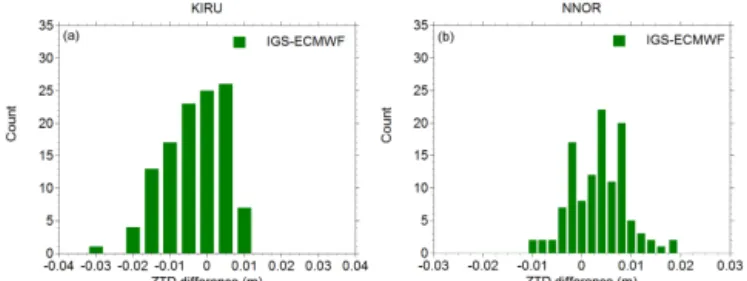
As typical examples, the ZTD series derived from ECMWF and IGS at stations KIRU (Kiruna, Sweden) and NNOR (New Norcia, Australia) are shown in Fig. 2. The ECMWF ZTDs are represented by black triangles, while the IGS ZTDs are displayed by red squares. One can notice that the ECMWF ZTDs show good agreement with the IGS ZTDs in general. Most of the peaks in the ZTD series, which are mainly caused by rapid changes of the water vapor content above a station, are captured by ECMWF and IGS solutions. The corresponding linear correlations between the ECMWF and the IGS ZTDs at stations KIRU and NNOR are illustrated in Fig. 3. It can be seen that ZTDs from the two so-lutions are highly correlated, with the correlation coefficients being about 0.93 and 0.97, respectively. Figure 4 presents the distribution of ZTD differences between ECMWF and IGS for the two stations during the same period. One can notice that the ZTD differences mainly range from−15 to 15 mm for station KIRU, and vary between−10 and 10 mm for station NNOR. The mean biases of the ZTD differences between the two solutions are−3.52 and 3.31 mm for the two stations and the root-mean-square (rms) values of the ZTD differences are 8.68 and 6.39 mm, respectively, showing an agreement at the millimeter level.
Figure 5 illustrates the map of station-specific mean bi-ases and rms values of ZTD differences between ECMWF and IGS for all stations. One can notice that the mean biases are within±15 mm, and that a better agreement between the ECMWF and IGS ZTDs for the high-latitude stations than for the low-latitude stations can be observed. The rms val-ues of the ZTD differences are less than 22 mm, indicating
Figure 3. Scattergram of ECMWF and IGS ZTDs at stations KIRU(a)and NNOR(b). The vertical and horizontal axes show ECMWF and IGS ZTDs (m), respectively. The correlation coeffi-cients (r) and the results of a linear regression are also displayed.
Figure 4.Distribution of ZTD differences between ECMWF and IGS at stations KIRU(a)and NNOR(b)for DOY 244–272, 2015.
a good agreement between the two solutions. Likewise, the rms values present a significant latitude dependence, which is smaller for high-latitude stations and larger for low-latitude stations, resulting from the distribution of atmospheric wa-ter vapor content with respect to the stations’ latitudes. The rms values for stations in high-latitude regions are generally below 15 mm, while the ones for the stations in low-latitude regions can reach up to 22 mm. For an enhanced perspective, the rms values of ZWD differences between ECMWF and IGS are shown as a function of the geographical latitudes in Fig. 6, where a fitted parabola is also displayed in black. It can be clearly seen that the rms values reveal strong de-pendence on geographical latitudes, which are larger in low-latitude (moist) regions and smaller in high-low-latitude (dry) re-gions. Similar findings were demonstrated in Dousa and Ben-nitt (2013), where a strong latitudinal dependency of ZTDs from the UK Met Office global model with respect to GPS ZTDs was described.
3.2 Multi-GNSS PPP results
con-Figure 5.The map of the station-specific mean biases (top) and rms values (bottom) of ZTD differences between ECMWF and IGS for DOY 244–272, 2015.
sidered in this study. The post-processing weekly solution is used as the reference position. The convergence time is de-fined as the time required for the horizontal components to be better than 10 cm, and the one needed for the vertical com-ponent to be better than 20 cm.
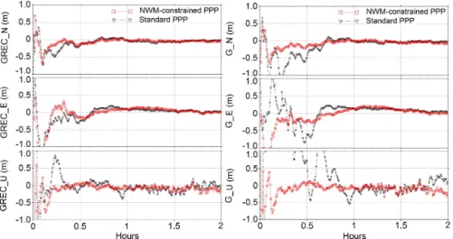
As an example, Fig. 7 illustrates the estimated north, east, and vertical coordinates obtained from the two multi-GNSS PPP processing methods at station WIND (Windhoek, Namibia; 22.57◦S, 17.09◦E) on 12 September 2015. As a reference, positioning results derived from the stand-alone GPS PPP are also displayed applying similar strategies as the multi-GNSS processing. The standard PPP solutions are shown by black triangles, while the NWM-constrained PPP solutions are shown by red squares. The left figures show the multi-GNSS results. It can be seen that it takes about 17 min for the NWM-constrained multi-GNSS PPP to achieve an accuracy of better than 10 cm for the north component, in comparison to 25 min in the case of the standard PPP so-lution. The convergence time is shortened by about 32.0 % by using the NWM-derived tropospheric delay parameters. Meanwhile, the positioning series of the standard PPP solu-tion show a larger jump than that of the NWM-constrained PPP solution.
As for the east component, a convergence time of about 40 min for the standard vs. 25 min for the NWM-constrained PPP solution is noticed. Accordingly, the solution con-vergence is improved by about 37.5 % with the NWM-constrained PPP. For the vertical component, a convergence time of about 20 and 15 min is required for the standard PPP solution and the NWM-constrained PPP solution,
re-Figure 6.The rms values of ZTD differences between ECMWF and IGS as a function of geographical latitudes. A fitted second-order polynomial is also shown in black.
spectively, indicating an improvement of about 25.0 % when applying the NWM-constrained PPP. Besides, the position-ing series exhibit many more jumps and fluctuations with the standard PPP solution, in particular before the solution con-vergence, which was significantly improved when the NWM-constrained PPP is performed.
As shown in the right figures, for the standard GPS PPP, an accuracy of better than 10 cm is obtained after about 50 and 60 min for the north and east components, respec-tively. In comparison, it takes about 20 and 40 min for the NWM-constrained GPS PPP solution to become converged for the north and east components, shortening the solution convergence time by about 60.0 and 33.3 %. In the NWM-constrained GPS PPP solution, a convergence time of about 10 min is required for the vertical component, in comparison to 50 min in the case of the standard GPS PPP solution, re-vealing an improvement of up to 80.0 %. Moreover, it can be found that the NWM-constrained PPP reveals significant contribution to improving the positioning series of all three components, showing more stable and less fluctuated results. Furthermore, it is noteworthy that the positioning perfor-mance, not only the convergence time but also the position-ing series of the GPS-only solution (right figures), becomes remarkably improved with the multi-GNSS processing (left figures). In addition, the corresponding summary over the so-lution improvements of the NWM-constrained PPP with re-spect to the standard PPP for both multi-GNSS and GPS so-lutions is listed in Table 1.
Figure 7.The multi-GNSS PPP (GREC) solution (left) and the stand-alone GPS PPP (G) solution (right) at station WIND (Windhoek, Namibia; 22.57◦S, 17.09◦E) on 12 September 2015 (DOY 255 of 2015). The standard PPP solutions are shown by black triangles, while the NWM-constrained PPP solutions are shown by red squares.
Table 1.The summary over the solution improvements of the NWM-constrained PPP with respect to the standard PPP for both multi-GNSS and GPS solutions.
Standard PPP NWM-constrained PPP Improvement
N E U N E U N E U
(min) (min) (min) (min) (min) (min)
Multi-GNSS 25 40 20 17 25 15 32.0 % 37.5 % 25.0 %
GPS 50 60 50 20 40 10 60.0 % 33.3 % 80.0 %
general, the positioning accuracy of the north component is better than that of the east and the vertical components, while the vertical component performs the worst, which may be at-tributed to the configuration of the satellite constellation.
For the north component, the rms values obtained from the NWM-constrained PPP solution are smaller than the ones from the standard PPP solution at the same session length, especially before the convergence. The positioning accuracy for the north component achieved with the NWM-constrained PPP is improved by about 2.5 % compared to the one with the standard PPP. Besides, a convergence time of about 20 and 25 min is observed for the NWM-constrained PPP solution and the standard PPP solution, respectively: an improvement of about 20.0 %. In terms of the east com-ponent, higher accuracy can be found again for the NWM-constrained PPP solution, with the rms values reduced by about 12.1 %. Meanwhile, the NWM-constrained PPP solu-tion takes about 17 min to become converged in comparison to 25 min for the standard PPP solution, a significant reduc-tion of about 32.0 % in the convergence time.
As for the vertical component, it can be noticed that the po-sitioning accuracy achieved from the NWM-constrained PPP solution is obviously higher than that from the standard PPP solution, an improvement of about 18.7 %. More than 20 min are required for the standard PPP solution to obtain
conver-gence, while the NWM-constrained PPP solution becomes converged in less than 15 min, indicating an improvement of more than 25.0 %.
4 Conclusions
We developed a NWM-constrained PPP processing sys-tem where tropospheric delay parameters derived from the ECMWF analysis were applied to multi-GNSS precise posi-tioning. Observations of stations from the IGS MGEX net-work were processed, with both standard PPP and the de-veloped NWM-constrained PPP algorithm. The accuracy of the tropospheric delays derived from ECMWF was assessed through comparisons with the IGS final tropospheric delay products at all IGS MGEX stations. The positioning per-formance, including convergence time and positioning ac-curacy, achieved with the NWM-constrained PPP were in-vestigated. The benefits of applying tropospheric delay pa-rameters from the NWM to improve multi-GNSS PPP were demonstrated by comparing with the standard PPP solution.
Figure 8.The rms values for the north, east, and vertical components with multi-GNSS PPP solution, shown at different session lengths (5, 8, 10, 15, 17, 20, 25, 30, 40, 50, and 60 min) for all 21 four-system stations of the MGEX network from 1 to 30 September 2015. The standard PPP solution is shown in orange, the NWM-constrained PPP solution in green.
low-latitude stations can be noticed. Both the mean biases and rms values are smaller for high-latitude (dry) regions and larger for low-latitude (moist) regions, revealing significant latitude dependence. These may be accounted for by the dis-tribution of atmospheric water vapor with respect to station latitudes. Furthermore, most of the peaks in the ZTD series, which are attributed to the rapid changes of the water va-por content above a given station, can be captured by both ECMWF and IGS solutions.
For the north component, it takes about 20 min for the NWM-constrained multi-GNSS PPP to achieve convergence, in comparison to 25 min for the standard PPP solution, show-ing a reduction of about 20.0 % in the convergence time. An accuracy of better than 10 cm is achieved for the east component after a convergence time of about 25 and 17 min from the standard and the NWM-constrained PPP solutions, respectively. The convergence time is shortened by 32.0 % with the NWM-constrained PPP. For the vertical component, a convergence time of about 20 and 15 min is required for the standard PPP solution and the NWM-constrained PPP solu-tion, respectively, indicating an improvement of about 25.0 % when applying the NWM-constrained PPP. Meanwhile, the positioning accuracy obtained from the NWM-constrained multi-GNSS PPP solution is also improved in comparison with the standard PPP solution after the same session length, in particular before the convergence. An improvement of po-sitioning accuracy resulting from the NWM-constrained PPP solution of about 2.5, 12.1, and 18.7 % for the north, east, and vertical components, respectively, can be found.
Besides, the positioning performance of the NWM-constrained GPS PPP solution achieves remarkable improve-ment compared to that of the standard GPS PPP solution, with the convergence time shortened by 60.0, 33.3, and 80.0 % for the north, east, and vertical components, respec-tively, as well as more stable and less fluctuated positioning results for each coordinate component. Based on these re-sults, it can be concluded that the performance of precise positioning benefits greatly from the multi-GNSS fusion in comparison to the stand-alone GPS solution, which can be further improved when the tropospheric delay parameters
de-rived from NWM are implemented to the multi-GNSS PPP processing.
In future studies, we will investigate the performance of applying tropospheric delay parameters derived from the NWM into precise positioning with other single satellite nav-igation systems, such as the Russian GLObal NAvnav-igation Satellite System (GLONASS) and the Chinese BeiDou Navi-gation Satellite System (BDS). Another research focus is the evaluation of the accuracy and performance of different nu-merical weather models, in order to find the most appropriate one to improve precise GNSS positioning.
5 Data availability
The GNSS observations were obtained from the IGS MGEX project, available at http://igs.org/mgex (Mon-tenbruck et al., 2014). The IGS tropospheric products can be accessed at ftp://cddis.gsfc.nasa.gov/gnss/products/ troposphere/zpd. The ECMWF data (http://www/ecmwf.int/) are provided to GFZ by the German Weather Service.
Acknowledgements. Many thanks go to the International GNSS
Service (IGS) for providing multi-GNSS data and the IGS final tropospheric products. The ECMWF data are provided to GFZ via the German Weather Service (DWD). Cuixian Lu is supported by the China Scholarship Council, which is gratefully acknowledged.
The article processing charges for this open-access publication were covered by a Research
Centre of the Helmholtz Association.
Edited by: O. Bock
Reviewed by: two anonymous referees
References
Blewitt, G., Kreemer, C., Hammond, W. C., Plag, H.-P., Stein, S., and Okal, E.: Rapid determination of earthquake magnitude us-ing GPS for tsunami warnus-ing systems, Geophys. Res. Lett., 33, L11309, doi:10.1029/2006GL026145, 2006.
Boehm, J., Niell, A., Tregoning, P., and Schuh, H.: Global Mapping Function (GMF): A new empirical mapping function based on numerical weather model data, Geophys. Res. Lett., 33, L7304, doi:10.1029/2005GL025546, 2006.
Byram, S., Hackman, C., and Tracey, J.: Computation of a High-Precision GPS-Based Troposphere Product by the USNO, Proc. ION GNSS 2011, 19–23 September 2011, Portland, Oregon, USA, 572–578, 2011.
Chen, G. and Herring, T. A.: Effects of atmospheric azimuth asym-metry on the analysis of space geodetic data, J. Geophys. Res., 102, 20489–20502, doi:10.1029/97JB01739, 1997.
Dousa, J. and Bennitt, G. V.: Estimation and evaluation of hourly updated global GPS zenith total delays over ten months, GPS Solut., 17, 453–464, 2013.
Gao, Y. and Shen, X.: Improving ambiguity convergence in carrier phase-based precise point positioning, in: Proceedings of ION GPS-2001, 11–14 September, Salt Lake City, USA, 1532–1539, 2001.
Ge, M., Gendt, G., Rothacher, M., Shi, C., and Liu, J.: Resolu-tion of GPS carrier-phase ambiguities in precise point posiResolu-tion- position-ing (PPP) with daily observations, J. Geodesy, 82, 389–399, doi:10.1007/s00190-007-0187-4, 2008.
Ge, M., Zhang, H., Jia, X., Song, S., and Wickert, J.: What Is Achievable with the Current COMPASS Constellation?, GPS World, 11, 29–34, 2012.
Hobiger, T., Ichikawa, R., Takasu, T., Koyama, Y., and Kondo, T.: Ray-traced troposphere slant delays for precise point positioning, Earth Planets Space, 60, e1–e4, 2008a.
Hobiger, T., Ichikawa, R., Koyama, Y., and Kondo, T.: Fast and ac-curate ray-tracing algorithms for real-time space geodetic appli-cations using numerical weather models, J. Geophys. Res., 113, D20302, doi:10.1029/2008JD010503, 2008b.
Ibrahim, H. and El-Rabbany, A.: Performance analysis of NOAA tropospheric signal delay model, Meas. Sci. Technol., 22, 115107, doi:10.1088/0957-0233/22/11/115107, 2011.
Kouba, J.: A Guide to Using International GNSS Service (IGS) Products, available at: http://igscb.jpl.nasa.gov/igscb/resource/ pubs/UsingIGSProductsVer21.pdf (last access: 18 March 2016), 2009.
Kouba, J. and Héroux, P.: Precise point positioning us-ing IGS orbit and clock products, GPS Solut., 5, 12–28, doi:10.1007/PL00012883, 2001.
Lagler, K., Schindelegger, M., Boehm, J., Krásná, H., and Nils-son, T.: GPT2: Empirical slant delay model for radio space geodetic techniques, Geophys. Res. Lett., 40, 1069–1073, doi:10.1002/grl.50288, 2013.
Larson, K., Bodin, P., and Gomberg, J.: Using 1 Hz GPS data to measure deformations caused by the Denali fault earthquake, Science, 300, 1421–1424, 2003.
Li, X., Ge, M., Zhang, Y., Wang, R., Xu, P., Wickert, J., and Schuh, H.: New approach for earthquake/tsunami monitoring using dense GPS networks, Sci. Rep., 3, 2682, doi:10.1038/srep02682, 2013.
Li, X, Zhang, X., Ren, X., Fritsche, M., Wickert, J., and Schuh, H.: Precise positioning with current multi-constellation Global Nav-igation Satellite Systems: GPS, GLONASS, Galileo and BeiDou, Sci. Rep., 5, 8328, doi:10.1038/srep08328, 2015a.
Li, X. Ge, M., Dai, X., Ren, X., Fritsche, M., Wickert, J., and Schuh, H.: Accuracy and reliability of multi-GNSS real-time precise po-sitioning: GPS, GLONASS, BeiDou, and Galileo, J. Geodesy, 89, 607–635, doi:10.1007/s00190-015-0802-8, 2015b.
Li, X., Zus, F., Lu, C., Dick, G., Ning, T., Ge, M., Wickert, J., and Schuh, H.: Retrieving of atmospheric parameters from multi-GNSS in real time: Validation with water vapor radiometer and numerical weather model, J. Geophys. Res.-Atmos., 120, 7189– 7204, doi:10.1002/2015JD023454, 2015c.
Lu, C., Li, X., Nilsson, T., Ning, T., Heinkelmann, R., Ge, M., Glaser, S., and Schuh, H.: Real-time retrieval of precipitable wa-ter vapor from GPS and BeiDou observations, J. Geodesy, 89, 843–856, doi:10.1007/s00190-015-0818-0, 2015.
Lu, C., Li, X., Li, Z., Heinkelmann, R., Nilsson, T., Dick, G., Ge, M., and Schuh, H.: GNSS tropospheric gradients with high tem-poral resolution and their effect on precise positioning, J. Geo-phys. Res.-Atmos., 121, 912–930, doi:10.1002/2015JD024255, 2016.
Montenbruck, O., Steigenberger, P., Khachikyan, R., Weber, G., Langley, R. B., Mervart, L., and Hugentobler, U.: IGS-MGEX: preparing the ground for multi-constellation GNSS science, In-side GNSS, 9, 42–49, 2014.
Niell, A. E.: Global mapping functions for the atmosphere delay at radio wavelengths, J. Geophys. Res., 101, 3227–3246, 1996. Pany, T., Pesec, P., and Stangl, G.: Elimination of tropospheric path
delays in GPS observations with the ECMWF numerical weather model, Phys. Chem. Earth Pt. A, 26, 487–492, 2001.
Saastamoinen, J.: Contributions to the theory of atmospheric re-fraction – Part II. Rere-fraction corrections in satellite geodesy, B. Géod., 47, 13–34, doi:10.1007/BF02522083, 1973.
Zhang, X. and Andersen, O.: Surface ice flow velocity and tide re-trieval of the amery ice shelf using precise point positioning, J. Geodesy, 80, 171–176, doi:10.1007/s00190-006-0062-8, 2006. Zumberge, J. F., Heflin, M. B., Jefferson, D. C., Watkins, M. M., and
Webb, F. H.: Precise point positioning for the efficient and robust analysis of GPS data from large networks, J. Geophys. Res., 102, 5005–5017, 1997.
Zus, F., Dick, G., Dousa, J., Heise, S., and Wickert, J.: The rapid and precise computation of GPS slant total delays and mapping factors utilizing a numerical weather model, Radio Sci., 49, 207– 216, doi:10.1002/2013RS005280, 2014.
Zus, F., Dick, G., Dousa, J., and Wickert, J.: Systematic errors of mapping functions which are based on the VMF1 concept, GPS Solut., 19, 277–286, 2015a.