Water Alternatives 3(1): 137-153
The Fine Art of Boundary Spanning: Making Space for Water in
the East Netherlands
Jeroen Warner
CSTM Centre for Clean Technology and Environmental Policy, Twente University; and Disaster Studies Group, Wageningen University, the Netherlands; [email protected]
Kris Lulofs
CSTM Centre for Clean Technology and Environmental Policy, Twente University, the Netherlands; [email protected]
Hans Bressers
CSTM Centre for Clean Technology and Environmental Policy, Twente University, the Netherlands; [email protected]
ABSTRACT: The desire to comply with the European Water Framework Directive, which seeks to promote Integrated Water Management, has led to a large number of proposed projects that in turn make huge demands on the financial and administrative capacity of water managers, who need to combine multiple fields of interest and participation such as agricultural interests, regional economic development, natural values, water safety and water quality issues to complete each project. To achieve these goals, water managers will often need to negotiate and strike alliances with actors in other policy areas such as spatial planning and local and regional economic development.
The article first introduces 'boundary spanning' in a water management context. The concept builds on the concept of 'boundary work' as a strategy to arrive at organisational goals – to reduce uncertainty and deal with complexity in the organisational environment.
The contribution then discusses briefly two recent innovative regional water projects, both located in the East Netherlands: a retention basin project on the river Vecht and the planning of a new channel, the Breakthrough. It further analyses strategies pursued by 'boundary spanners' and integrates the analysis with that of a focus group workshop and interviews held with Dutch boundary spanners working for Dutch regional Water Management Boards. The cases show that it is preferable to apply boundary spanning strategies earlier rather than later, and that opponents are also aware of this option.
KEYWORDS: Boundary work, complexity, uncertainty, IWRM, Water Boards, Netherlands
INTRODUCTION
The concept of Integrated Water (Resource) Management (IWRM) has gained considerable momentum through the enactment of the European Water Framework Directive, which sets standards for a 'good environmental status' and public engagement. IWRM has been criticised for, among other things, its vagueness and ultimate impossibility to put into practice; 'full' IWRM1 at basin level is a mirage (Biswas, 2004; Molle, 2008). 'Lighter' forms of IWRM, however, which stop short of full integration, incorporation and mergers, and respect political and institutional realities, are quite conceivable;
1
however, these cross boundaries that have been previously uncrossed (Moriarty et al., 2004). The present article suggests that selective, pragmatic boundary crossing strategies at project level enable forms of inter-organisational coordination and harmonisation that help to achieve goals outside the reach of individual organisations.
The 1990s saw a rediscovery of the positive aspects of rivers in Western Europe. Rivers had long been seen as a threat (flood risk) and treated as a dumping site for agricultural and industrial waste or an alternative transport route, requiring their channelisation for navigation and flood disposal purposes. Rivers, however, were now acknowledged to also have natural, cultural, recreational, and amenity values and bring economic opportunity. 'Making space for rivers', as well as cleaning up and restoring them, proved a 'magic formula' combining many social desirables – quality, quantity, tourism, urban regeneration, economic growth – into multifunctional packages.
Integrating these multiple values triggered innovative approaches requiring new combinations of scales, actors, perspectives, strategies, and resources (Bressers and Kuks, 2004).
Integrating multiple water policy goals tends to require a degree of what organisational theorists call 'boundary spanning', which is the process in which members of an organisation participate in networks outside the organisation (Newell and Swan, 2000). Information about contingencies in the
o ga isatio ’s e i o e t eeds to ea h o ga isatio al de isio -makers so that the organisation can adapt. A 'boundary spanner' is the person responsible for the exchange of information between the organisation and its environment (Leifer and Delbecq, 1978). Networking is the predominant modus operandi of a boundary spanner, filtering information coming from the outside and leaving the organisation from the inside.
Nevertheless, while the boundary spanning literature focuses mainly on knowledge and uncertainty, we find that an important additional role of boundary spanning is coming to terms with different problem frames and actor configurations in the different policy arenas connected by an IWRM project, which becomes a contestable, and indeed contested, 'boundary object'.
The article first introduces the analytical concept of boundary spanning. It then introduces two illustrative Dutch case studies that shed light on the successes and risks of spanning/coupling as adaptive management strategies used by non-dominant water actors – regional water management boards – to design multifunctional river projects successfully: a retention basin project on a tributary of the river Vecht and the planning of a new channel, the Breakthrough, on the river Regge. Both the Vecht and the Regge are regional non-main river flows located in the east of the Netherlands.
SPANNING WHICH BOUNDARIES?
In governing people, three types of instrumental styles can be mixed and matched: coercion-regulation, material incentives and communicative governance. As water managers, Water Board dispose of some, if only weak, coercive instruments (hard power) to force others to comply with their policies, such as expropriation. Coercion in the form of expropriation is only practiced in Dutch water management if all else fails. The Water Board is an obligatory passage point for obtaining planning permission for infrastructural and urban development; negative Water Board recommendations are not easily ignored. However, in a tightly coupled policy network, where people meet each other in different policy arenas, it is seldom advisable to rub up the other actors the wrong way. The alternative (litigation) is not attractive, and some have explicitly renounced coercive instruments.
Financial incentives, the second type of instrument, are available, but despite their independent taxing capacity, the means of Water Boards to enter into big projects are limited. 'Carrots' therefore
eed to e fou d outside the Wate Boa d’s do ai . Se u i g fu ds e ui es oope atio ith othe s
to qualify for regional, national and European subsidies.
the intersubjective constructed demarcations between different social domains, establish "distinctions and differences between and within active systems that are created and agreed on by groups and individual actors over a long period of time while they are involved in those activities. As traces of past activities boundaries trigger learning and development" (Kerosuo, 2006). Some boundaries are deemed essential to preserving an absolute – a sense of identity or security – while different types can be crossed, blurred or dismantled (see table 1). When such boundaries, either physical or ideational, are highly institutionalised and sacralised, however, they are hard to negotiate and modify. The ideal-type
di isio et ee the legislati e, e e uti e a d judi ial a hes of go e e t Mo tes uieu’s Trias politica) or the jealously guarded boundaries to national territory are examples. In the Dutch water sector, for example, different alternatives for river management can be proposed, but the framework of river safety norms is non-negotiable, at least certainly not in the newly decided policy context in which, in principle, the accepted risk along large rivers will become ten times more ambitious (Deltacommissie, 2008).
A project at the interface of multiple domains, on the other hand, can be a boundary object that calls existing boundaries into question. A boundary object is an entity shared by several different communities, but viewed or used differently by each of them (Star and Griesemer, 1989). The appearance of boundary objects such as infrastructures crossing administrative and sectoral boundaries can incite actors to reconsider their boundaries – a re-e aluatio of o e’s ou da judg e t. The boundaries at issue result from decisions or judgments made by decision-makers, analysts, scientists, or practitioners. Boundary judgments concern issues such as what is your task, your domain? Due to the increasing complexity and dynamics of decision-making, more people in organisations find themselves at the interface between inside and outside, now and then. Such boundary spanners are individuals or subsystems at the outskirts of an organisation that exchange information with the organisational environment to engage with these bigger issues. For this, they look across disciplinary, institutional, geographic, temporal, and sense-making (framing) boundaries. To avoid too much detail, the description and analysis below will focus on the characteristics of the 'spanning activities' over time rather than those of the spanners themselves.
Table 1. Boundaries can be crossed, blurred or dismantled (Bressers and Lulofs, 2010).
Type Example of boundary Crossing boundaries
Enclosing boundaries River embankments Building on a floodplain; moveable dikes
Intermediate boundaries Different systems and disciplines
Interdisciplinary approach; policy-field boundaries between scientific disciplines: water management, spatial planning, science and practice, economy and sociology Sense-making boundaries Ideas or concepts through
which meaning is given for actions in the social systems
Reframing river planning as promoting 'spatial quality'
Temporal boundaries Flood response (reactive) Boundaries of phases in the safety chain
Geographic boundaries River sections, polders Integrated catchment management
(the national water authority, which is traditionally in charge of navigation and main river flood management between the dikes) to learn new negotiation skills – to be a tough negotiator with other stakeholders with claims to space, rather than keeping to its previous patronising/authoritarian stance.2 Moreover, although risk preparedness is still underdeveloped in Dutch flood planning, Dutch flood policy is moving in the direction of covering all phases of the safety chain (proaction, prevention, preparedness, response, and aftercare) (Ten Brinke et al., 2005) in recognition of the residual risk of a river or sea flood occurring. This requires the Public Works Department to work with other departments, lower-level authorities and private and civic actors. The spread of public consultation and participation in the Netherlands has also led to a widening of the knowledge base and perceptions taken into account in water management.
This broadening leads to a crossing of intermediate boundaries: 'boundary work' is carried out between science and policy, as well as through the integration of local knowledge into the knowledge base underpinning decisions through the instatement of a focus group or participatory platform (klankbordgroep). The resulting extension and overlap of playing fields for water agencies require them to devise cross-boundary strategies.
So far, this has not extended much across national boundaries. Often, the polder rather than the river is the sensible management unit. In the Dutch context, all main rivers, for which the national department is responsible, are international, and sovereignty issues can prove surprisingly pertinent in transboundary water management.3 However, the Europea Wate F a e o k Di e ti e’s e phasis o basin-wide management has contributed to a shift in 'sense-making boundaries' in the Netherlands, i.e. when we start to redefine the concepts we work with on a daily basis. The shift in meaning of what constitutes the scale of water management encouraged selective cooperation at regional (Water Board) level with neighbouring countries, widening the geographic scope of river management.
ADAPTIVE MANAGEMENT
4In addition to boundaries of space and organisation, we observe a crossing of time boundaries. The complexity, diversity and dynamics characterising such situations mean that synoptic top-down planning becomes problematic (Kooiman, 1993). Problem definitions can be multiple and contradictory and may change over time, while opportunities for addressing the situation are often found 'as you go'. In such cases the policy process does not manifest itself as a series of consecutive plans; preparation, decisions, implementation and evaluation are interlinked by feedback loops. Rather, the dominant pattern can best be characterised by unpredictable and dynamic rounds of decisions, and phases are nested and interlinked (Teisman, 1992). While policy cycles assume a sequence of policy formulation, decision-making and implementation, boundary spanners indicate that in reality they are involved in many parallel and iterative processes. Playing the field means playing multiple chessboards. An
o ga isatio ’s o constituency or board of governors needs to be kept in the loop and give boundary spanners a mandate to operate in sometimes risky ventures. At the same time, a boundary spanner may be playing in multiple arenas outside the organisation – not only in the water arena, but also in spatial planning and environmental conservation. The other players are sometimes the same people, while the stage of the policy game may be different or appear in different power configurations.
Adaptive management is not a straightforward itinerary from A to B, with fixed goals and processes. It is iterative, a task of 'learning by doing', requiring actors to return and re-evaluate earlier milestones
2
Interview with R. Jorissen, RIKZ (State Institute for Coast and Sea), 15 November 2005.
3
A risk to regional boundary spanners is that the network arrangement is superseded by hierarchy when the projects or bargaining processes are elevated to a national security and sovereignty issue. The national water authority can decide to take over in a top-down decision mode, which was encountered in the dispute over the international River Scheldt/Escaut (De Vries, 2008; Warner and Van Buuren, 2009), but not in the present cases.
4
and landmark agreements in light of progressive insight. While IWRM is largely rooted in the idea of rationality, adaptive management preaches flexibility whereby information is dispersed and ambiguous. Adaptive time management also includes exploiting windows of opportunity such as a (physical or policy) crisis (Kingdon, 1995), the handling of which releases resources and goodwill. An example is the high water event of 1993, which showed how unwise it was not to have an evacuation plan. The Rivierenland Water Board then led the design of an evacuation strategy, which was tested at the next high water event in 1995, when more than 200,000 people were evacuated as the water started to rise. While traumatic to many – and its emergency rationale disputable – the evacuation was never really contested. We will encounter some windows of opportunity in the case studies below, which demonstrate that management is a continually adaptive process rather than pre-planned.
This pragmatic, flexible form of 'muddling through' (Lindblom, 1959) invites analyses drawing
i spi atio f o Ma h a d Olse ’s 'garbage can theory', in which actors couple streams of solutions and pro le s Ma h a d Olse , 9 9 , a d Ki gdo ’s 'windows of opportunity' (Kingdon, 1995). Planning and implementation, problems and solutions in this perspective are not necessarily sequential, as the policy process becomes jumpy rather than linear and the network, topics and resources involved are akin to streams.
CASES AND METHOD
The two case studies discussed in this contribution are set in a Dutch regional water management context that was already considerably decentralised, and even more so in the early 1990s, as the Public Works Department started to divest some of its management tasks to Water Management Boards.
A desire to meet the water quality standards set out by the European Water Framework Directive, which calls for integrated water management, has led regional water managers in the Netherlands to define a large number of projects that in turn make huge demands on the financial and administrative capacity of water managers. Regional water managers, however, lack the resources and legal means to carry a project or policy through on their own. Since every square foot has been planned in the Netherlands, any project that requires space for water renders multifunctional solutions inevitable. Therefore, water managers need to combine multiple fields of interest and participation to complete each project such as agricultural interests, regional economic development, natural values, water safety, and water quality issues. They find they have to engage actors at higher, equal and lower scales, as well as within all social domains – private, public and civil society. They therefore rely on subtle forms of network management (Williams, 2003; Carlile, 2002) with actors that they are horizontally, vertically or diagonally connected with to achieve ambitious goals.
To accomplish these goals, water managers will often need to negotiate and strike alliances with actors in other policy areas such as spatial planning and local and regional economic development. A crucial resource they need in order to achieve these multiple goals is space. The 'MacSharry reforms' of the European Common Agricultural Policy (1991), instigating a move from (over)production to agricultural extensification and socio-environmental protection, opened a welcome window of opportunity for Dutch water management. These measures promised to create space for rivers in a densely populated country, which could help to achieve a higher level of safety combined with other desirable outcomes. As we shall see, however, the agricultural sector predictably did accede willingly.
The cases below, set in the East Netherlands (see situation maps in figures 1 to 3) and described in greater detail in Bressers and Lulofs (2010), may illustrate and, to a degree, complicate these issues. For the first case, which discusses the Breakthrough brook (creek), ten interviews were conducted, while for the second, North and South Meene, fifteen interviews were held. The interviewees included Water Board actors at all levels; provincial, municipal authorities, consultants and interested citizens. A workshop session was held with various internal stakeholders to reconstruct the story. Each was asked to relate the case history story with emphasis on the policy process, interpretation of own and other
a to s’ p o le defi itio s, apa ities a d oti atio s, a d oope atio a d o fli t d a i s,
charting how the actors anticipated and resolved problems.
Three workshops were held with self- and other-labelled boundary spanners within the Water Management Board and provincial and municipal authorities. This included a focus group workshop held in February 2008 with boundary spanners working for Dutch regional Water Management Boards. On the basis of interviews and a workshop with people within Dutch Water Board who identified themselves or were identified by others as boundary spanners, we could identify strategies employed by water managers. These key players were invited by facilitators to discuss the many challenges of boundary spanning.
Finally, a brief document5 as p ese ted at the ell atte ded a ual egio al ate a age s’ meeting in May 2009, and six interviews were held in subsequent months with stakeholders to discuss its contents. In addition, official and grey documents were consulted.
Figure 1. Location of the Breakthrough and North and South Meene cases in the Netherlands.
Case study 1: the Breakthrough channel
In 1992, the Regge en Di kel Wate Ma age e t Boa d, o e of Holla d’s t e t -seven regional water authorities, published a strategic plan announcing the construction of a new channel, 13 km long and 25 m wide, to separate rural from urban water to improve surface water quality for the region. At the
5
www.levenmetwater.nl/static/files/Eindversie_december_2009_handreiking_bestuurlijk_schakelen.pdf North and South Meene
Breakthrough
time, clean countryside water mixed with polluted water in the urban system in a densely populated region. A prefeasibility study led to an initial plan, which was presented in 1997. After much boundary spanning, the design developed from a traditional, narrow and deep channel to a meandering, shallow stream. This set in motion multiple 'games of chess' which made a simple plan much more complex. Let us see how those games unfolded.
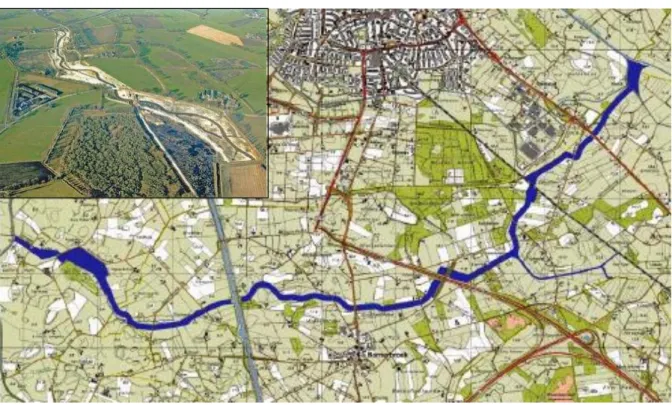
Figure 2. First stretch of Breakthrough brook (inset), and map of the middle stretch of the Breakthrough channel in 1999 (reproduced with permission, Arcadis Heidemij Advies).
Realising its dependence on other governmental actors and their resources (van den Brink and Meijerink, 2006), the Water Board started to 'span boundaries' early on by involving other actors and sectors in its policy network. It invited leading municipal and regional public officers, as well as a
egio al Fa e s’ U io leade , to sit o the p oje t’s stee i g o ittee. The pla as e ei ed ell
by other actors in the policy network, as it linked well with their ambitions. To initiate the proceedings, the provincial authorities, responsible for the planning of ecological corridors, indicated that they were going to cooperate on condition that the plan would conform to the provincial Nature and Countryside Policy Plan, which made it subject to environmental conditions such as a wide green margin bordering the river banks. The banks of the new stream would have to be widened by 25 m of greensward on both sides in rural areas, and a further environmental reservation of up to 75 m where the stream bordered on urban functions and infrastructure. This implied a rather larger land take than expected, and could easily clash with a new business park area, which would sit right next to the middle stretch of the Breakthrough.
operation, a wider brook would constitute a physical boundary against the more worrying threat of further urban expansion.
Funding also promised to be a problem, but the steering committee member representing the town of Wierden, where the new channel was to begin, had an innovative proposal for that. He happened to chair the regional Land Consolidation Committee. On his instigation, the Province proposed to include the Breakthrough brook in an ongoing land consolidation project for tackling drought problems in the area. The brook could help to retain the relatively rural stretch of water, which was flowing out of the region too quickly. Its inclusion would enable the Province to use its legal powers and funds to help construct the channel. Under the Consolidation Act, the allocation of land consolidation funds for ecological projects was not allowed, but the provincial authorities knew that the Agriculture Ministry was about to relax this ruling. This, however, meant waiting until the Act had been passed in Parliament, which would take time.
Creative thinking on the parts of both the Water Board and steering committee thus led to the identification of opportunities, but at the price of broadening the problem definition to satisfy the conditionalities that came with the opportunities.
The Wate Boa d’s i ediate poli et o k6
thus assisted with creative thinking helping to established conceptual and practical linkages. Nevertheless, external opposition was mounting – one village along the stream opposed the ecological connectivity plan. The Wierden steering group member was taken to task in his home constituency for proposing to redefine the regional land consolidation plans in ecological terms. As the 'green brook' would be crossing privately owned agricultural land, it would restrict their agricultural operations, while waiting for the new consolidation rules to come through also meant the delay of the land consolidation process as a whole. Farmers lobbied Wierden municipality councillors, where the new stream was to begin. The councillor stuck to his guns, though, and the la d o solidatio pla ulti atel p o ided la it a out the fi st st et h of the ook’s oute.
The next stretch bordered on the prospective regional business park and was, meanwhile, still beset with uncertainty. To assess the suitability of planning permission for the business park, an Environmental Impact Assessment (EIA) was started. As the EIA required the publication of the initial memorandum, landowners realised they were sitting on 'hot land'. As a consequence, land prices skyrocketed. In the Netherlands, an EIA can take many years to reach completion, so, to prevent this from happening, the provincial authorities, who stood to benefit from both the Breakthrough brook and the regional business centre, pragmatically divided the EIA procedure in two – a location impact statement, open to public consultation, and the actual detailed planning.
The local widening of the river and its banks tied in well with a campaign conducted by the national government in response to recent, unforeseen flood events in 1993 and 1995, arguing that the rivers needed space. This argument gained force after heavy rainfall in 1998, which the existing water system could not handle. As a result, flood safety rather than improving water quality, became core to the Breakthrough rationale. Widening the river and its adjacent green zone would create more flood storage capacity, while recreational values also found their way into the objectives. The new functions again meant a considerable change of objective.
'Making space for water' had also become a European concern, and the Breakthrough manager was delighted to find that spatial planning projects that made space for water were now eligible for European subvention under the European programme to stimulate regional cooperation across national borders, known as the Interreg Rhine Meuse Action programme (IRMA).7 Seizing this opportunity,
6
The concept of policy networks refers to the fact that "policy-making and implementation involves a large number and wide variety of public and private actors from the different levels and functional areas of government and society" (Hanf and
O’Toole, 1992).
7
however, required speedy action inasmuch that subvention could only be realised after concrete work had been done. Funding overtook the legal and practical processes the water authority was pursuing, including a public tendering process that itself depended on legal procedures and left many avenues open for public opposition. The water authority, at the very least, had to secure title to the land needed for the Breakthrough brook. Additional funds were secured from a new national climate change adaptation programme subsidising flood prevention and storage capacity, after emphasising flood control as one of the purposes of the project. As the multi-purpose project by now had become quite complex, the need was perceived to split project leadership between a financial coordinator and a project coordinator. This brought a fortuitous change of project leadership. The new executive, who came in from the national land consolidation service, coincidentally had been involved in the very first Breakthrough project sketches as a student while at Wageningen (Agricultural) University. This helped the integration of provincial land consolidation and inter-municipality channel planning.
This was still needed, as four municipalities would have to change their zoning plans to enable the brook project. The water authority successfully requested Wierden local authority to depart from its zoning plan to enable the channel to go ahead, a departure that required a public hearing which revealed a desire for greater public involvement. The hearing also brought proposals for modifications which were incorporated by the water authority. The water authority promised the town of Wierden
that all possi le pla i g light ould e o pe sated at the ate autho it ’s e pe se. The to had
to admit that, although this promise was not yet legal, it would be possible, as inside information revealed that central government was going to scrap the right to compensation for planning blight.
However, the farmers in the second stretch of the brook were unhappy, and hit upon a bright idea. They could accept a buffer zone in the interest of storm water management, but did not believe in nature development. They assumed the ecological corridor function had only been put in place to gain EU funding, and so proposed an alternative that reduced the greensward to the original 25 m, i.e. without the environmental strip, and to offer land elsewhere by way of compensation for the loss of the green strip in the project area. To enable this alternative, they pragmatically cooperated with a
atu e o se atio g oup that o ed the alte ati e g ee a ea. Not o l the egio al Fa e s’ U io ,
but also residents and one political party appreciated the alternative, while some provincial council members wanted to study the new arrangement before giving planning permission for the changes in the municipal zoning plan – yet another costly delay for the project. At this time, the first stretch was already being dug without certainty on the next stretch; a major risk for the Water Board. A compromise was reached for the second stretch in January 2005 when the water authority accepted a deal where agricultural use would be allowed for seven years more, after which the area bordering the river would ultimately become a natural reserve. This bought time for coming to an agreement with landowners. By this stage, some residents felt the buffer would protect them from an even more threatening development – the regional business park – and supported the deal.
A practical obstacle at the implementation stage was that planning permission was also needed from the Ministry of Public Works, a time-consuming procedure. The Public Works Department, however, proved very helpful in overcoming the practical challenges of how to make the stream cross a motorway and a railway. The Ministry found funding for an ecological underpass and was prepared to spend it on the Breakthrough.
We have seen that a lot of boundary spanning and coordination between sectors and functional planning clearly went on, which at times yielded unexpected intelligence and opportunities.
No etheless, this p o ed a pe ilous st ateg ith a pitfalls, hile the fa e s’ outreach to the nature conservationists revealed that opponents also know how to span boundaries.
The North and South Meene project
and empties into Lake Ijssel in Central Netherlands. The original idea was to designate a 400 ha wetland along this river, known as North and South Meene, as a Site of Special Scenic Interest by enhancing its natural values in a precious cultural landscape and redesigning it as a retention basin.
Figure 3. Location of the river Vecht (incerpt) and North and South Meene (Noord & Zuid Meene).
Germany
Funding seemed straightforward – there were subsidies available for nature development, and the
efo of the Eu opea U io ’s Co o Ag i ultu al Poli i the ea l 99 s had led to the set-aside of a considerable area of agricultural land in the region. The provincial authorities, charged with ecological corridors, however refused to allow already fallow agricultural plots to qualify for subsidies in creating the corridor for which a minimum hectarage of contiguous land was required. As a consequence, productive agricultural land would have to be freed up instead, requiring buying out farmers. Its inflexible sense-making boundary of what constitutes 'natural values' incited the Province
ot to i lude the Mee e’s desig atio as a ate sto age a ea i its spatial pla i g do u e t.
This apparent technicality proved important when, in 1998, heavy rainfall led to safety concerns in four villages along the river Ijssel. Following a classified security scenario for the region, the decision was taken to prepare the area for evacuation and cut the dikes for controlled flooding. The cuts were only cancelled at the last minute, but evacuation was already in place. At a public meeting organised by
the Fa e s’ U io , eside ts de a ded that dike uts a d e a uatio ould e e e a optio agai ,
which the water authority solemnly promised. As far as the Water Board was concerned, the Meene area was now definitely going to be a retention area for regional flood safety purposes; its retention capacity was expected to reduce the downstream flood peak by 13 cm.
The ete tio a ea, though, t igge ed o plai ts f o eside ts that the p oposed dikes’ lo atio s
had been planned too close to their houses. Furthermore, famers felt their interests had been sacrificed for downstream interests, and that they had been presented with a fait accompli. To ease the tension, the Water Board devised an alternative. Instead of diking up residential areas in the retention area, the board proposed to place the existing buildings and roads on small mounds so that they would remain dry in case of a flood.
This did not appease all residents, though. In 2000, quite late in the day, yet another administrative
hu dle p ese ted itself he the u i ipal autho it , pu po ti g to a t o ehalf of the a ea’s eside ts,
claimed it would need to ha ge the u i ipal zo i g pla fo all to e a le the Wate Boa d’s alternative for the Meene, and threatened to halt all activities until administrative procedures were completed. This also connected to the issue of who was to compensate the farmers for damage incurred by the project (planschade), and by how much. The provincial authority, as the superior administrative layer, could have stepped in to settle things but refused to do so, with the end result that the water authority, realising the impossibility of going back on promises made after the flood, had no alternative but to comply. Provincial planning permission was issued eventually just months before the IRMA deadline.
Mirroring the Breakthrough case, this deadline gave residents of the Meene an advantage in land acquisition negotiations. The provincial authority was still not legally backing land acquisition for the project, as it had not integrated the plans in its spatial planning documents.8 To meet the European deadline, implementation would have to start without the formal planning procedure being finalised. Expropriation was not an option, and inhabitants held a race to the top for the best compensation rates. To a degree, this incentive helped inasmuch that one farmer, who was previously opposed to the project, now decided to terminate his operation and offered up land, breaking the impasse. Nevertheless, although almost every farmer reached an agreement with the Water Board, a small group was still prepared to block everything, forci g the Fa e s’ U io to a t as a oke . The U io realised that residents and land owners would all be negatively affected if individuals succeeded in blocking realisation through appealing to administrative courts; in other words, the Water Board might call the whole plan off. As it happened, a farmer committee member in a local commission – set up to create a plan for revitalising the area in which the planned retention basin was to be embedded – had been accused of mixing personal and professional interests. To improve their public relations, the
Fa e s’ U io de ided to ea h out o e to the othe eside t stakeholde s, a d a e to a t as a go -between (broker) -between residents and the authorities. In this role they reached an agreement with the Water Board that made explicit the terms of turning the area into an official retention basin.
Due to the time pressure, building started in very inclement weather, which, everyone agreed, was sheer madness. Nonetheless, the works were built in four years, and now compare favourably with similar projects.
Reflection and conclusions
I toda ’s poli a e a, it ould e ha d to o ei e of e i o e tal de isio s that do ot i ol e
some kind of boundary spanning. In the Netherlands, space is at a premium – virtually every square foot has been planned and allocated, which makes it very easy for a project initiator to step on other
a to s’ toes. Ho e e , the degree and timing of boundary spanning can make a crucial difference. The attitude towards timing may be termed 'proactive' and 'reactive'. It appears that the key advantage of early (proactive) rather than late (reactive) action is the momentum that comes with taking the initiative, as ell as the deg ees of f eedo it eates, so that o e’s ha d is less easil forced by unexpected developments and constraints. It does not guarantee a successful outcome, but it certainly reduces the risk of project stagnation.
8
Let’s look i to so e of the diffe e es a d si ila ities i t pes of spa i g, ea ti e spa i g,
counter-spanning, etc (see also table 2). How did spanning take shape, and with what kind of effects? Both water managers in the two cases outlined above initially started their boundary spanning to reach multiple objectives. Two of these objectives could be expected to clash in both cases – nature vs. agriculture. While natural value enhancement was a sine qua non for provincial and European support, land acquisition to create space for the project required a keen eye on regional agricultural interests.
A crucial difference between the cases is the amount of discursive flexibility (and policy drift) facilitating boundary spanning. The plans to dig a new channel were sufficiently unspecific to allow the Breakthrough project to be changed and augmented considerably without looking foolish. In the Meene case, on the other hand, the water authority had painted itself into a corner by promising that controlled flooding would never happen again in the Meene, and by subsequently presenting blueprints. It is true that a security frame ('securitisation', after Buzan et al.,1998) can revive moribund planning processes (see also the Maaswerken project, Van de Grijp and Warner, 2001; Warner, 2010), but by placing a non-negotiable boundary, drawing a line in the sand, the Meene project lost much of its flexibility as a boundary object (Turnhout and Leroy, 2004). Resident and farmer disenchantment with security-mode decision-making caused distrust of the water authority. It was they who had demanded flood measures, but as the memory of the flood faded, the downside of the proposed intervention became apparent and controversial. They became aware of, and therefore used, their obstructive power.
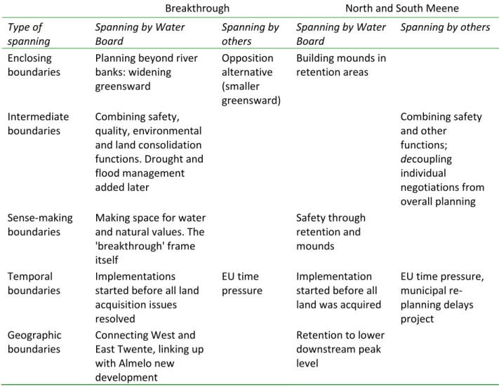
Table 2. Boundary spanning tentatively applied to the Breakthrough and North and South Meene projects (after Bressers and Lulofs, 2010).
Breakthrough North and South Meene
Type of spanning
Spanning by Water Board
Spanning by others
Spanning by Water Board
Spanning by others
Enclosing boundaries
Planning beyond river banks: widening greensward Opposition alternative (smaller greensward)
Building mounds in retention areas
Intermediate boundaries
Combining safety, quality, environmental and land consolidation functions. Drought and flood management added later Combining safety and other functions; decoupling individual negotiations from overall planning Sense-making boundaries
Making space for water and natural values. The 'breakthrough' frame itself Safety through retention and mounds Temporal boundaries Implementations started before all land acquisition issues resolved
EU time pressure
Implementation started before all land was acquired
EU time pressure, municipal re-planning delays project
Geographic boundaries
Connecting West and East Twente, linking up with Almelo new development
The gold rush of opportunity can also incite unstoppable dynamics that blind actors to downsides and alternatives, bringing another sort of closure (this phenomenon could be called 'opportunitisation', see Warner, 2004). The attempt to use a more integrated approach by both projects got a boost from external opportunities to span across boundaries, such as the safety and drought management domains, but both linkages also turned out to be constraining and to incite anxiety, confusion and opportunism. This could easily shift the power balance against the initiating Water Management Board. It also increased the complexity of the project to Christmas tree proportions, which made the project harder to manage and placed it at risk from 'mission creep'.
The link with Europe provided money, but the time constraint attached felt like the Sword of Damocles. The Province stepped back, leaving the water authority to fend for itself, while several stakeholders pursued only their own self-interest.
European subsidies proved to be both an opportunity and a problem, as the time to spend the money was limited. Lengthy spatial planning procedures likewise posed hurdles. Land acquisition gave landowners a strong hand, as they could capitalise on their ownership of 'hot land'. In the Meene case, time was a constant pressure; the authority successfully managed to buy precious time by convincing the European funders to accept a postponement, pushing the temporal boundary.
The Regge and Dinkel water administration, realising that building a new stream would be an uphill battle, thought proactively, and when running into problems, mostly found creative ways out – indeed, breakthroughs. The Velt en Vecht water authority showed foresight in devising a multifunctional, trans-sectoral solution, but due to time constraints invested less in relations with other stakeholders.
Spa i g o e tio s e e o l ade ith the oa d’s a k agai st the all. To ualif fo Eu opea
subsidy, both Water Boards had to accept 'being coupled' by the European Union, whose project funding required trans-sectoral links. As the European deadline drew ever nearer, the Water Board was controlled by the clock rather than playing for time, taking away the option of shifting gears.
This was not the only form of reactive spanning. Unlike Regge en Dinkel, Velt en Vecht was confronted by an uncooperative local government and provincial authority, which lost precious time. Reactive spanning likewise occurred with respect to citizen protest. The crisis-induced consensus was interpreted by the water authority as a licence to operate, broadening their domain, which then
lashed ith the fa e s’ ou da judg e ts. I oth ases, the ate autho it ea ted i pa t
accommodating opponents, but also in part seized the initiative by coming up with a new, breakthrough approach (the mounds plan) and a new project leader with a different attitude and network.
While we may be tempted to conclude that the Regge and Dinkel Water Board was luckier in working in a more flexible and creative project environment than their counterparts on the river Vecht,
this fle i ilit appea s to e att i uta le i o s all easu e to the oa d’s ea l a ti atio of its poli
network. Nonetheless, the board also seems to have failed to anticipate well enough that the opposition in the policy arena could show similar creativity by linking with conservation organisations. In such instances, boundary spanning by project initiators invited counter-spanning by other stakeholders. Counter-spanning was found in both cases: in the Meene case, the private sector was brought in, which introduced fresh knowledge, but also had its own commercial interests magnifying those of their clients. In the Breakthrough case, environmentalists and farmers forged an alliance of convenience. In such situations, the policy arena starts to look a lot like a standoff between two advocacy coalitions (Sabatier, 1988) across sectors, a multi-stakeholder action platform established because there is a common adversary. What really makes the difference between proactive and reactive boundary spanning is that proactive boundary spanning enables spanning over sector boundaries by strategies that are based on spanning scale and/or time boundaries, just because there is little fixed as yet and time pressure is not felt.
increase of complexity and redundancy of the policy network and social learning, leading to more sustainable, more participatory and integrated water management, this is not what boundary workers always aim for. Some of the strategies in fact turn out to reduce complexity by selectively decoupling/un-spanning certain arenas, long-term goals or network actors from the process. It is at times pragmatically sensible not to involve certain others or to drop policy goals, so as not to lose the momentum.
The Meene case, however, showed that after an actor or sector is uncoupled from the process, inter-sectoral 'respanning' to include environmental goals is possible – a farmer offered land to enable the development of natural values once the price was high enough.
These brief case descriptions indicate the use of realism with regard to boundary spanning as an adaptive management approach. Both case experiences and workshop results reveal a prevalence for strategies that conserve positive working relations and a value-based, but hard-nosed, business orientation.
SOME RISKS
Boundary spanning also implies risk taking. For both projects, the European Interreg subsidy meant a very welcome injection if all turned out well, but would entail immense costs in the worst case scenario. Starting a project while procedures were pending and land titles not yet secure also exposed the project to major hazard. The Breakthrough initiators, particularly, relied on informal information about upcoming policy changes and funds, which might well never have materialised.
Apart from financial and procedural risk, there is the risk of opposition from other actors in the arena, who refuse to play along with the boundary spanner. How attached actors may be to their boundaries is a function of motivation, cognition and resources (Contextual Interaction Theory, as described in Bressers and Lulofs, 2010). The early involvement of other actors helps to involve internal
a d e te al a to s i o e’s o f a e. I flue i g a d o u i ati g ith othe s i gs the
predictability of expectations, therefore lengthening the 'shadow of the future'9 in a complex and/or unstable environment. Obviousl , ea l o ta t ea s o e is also e posed to othe a to s’ f a es. It appears from the interviews with water board boundary spanners that they rarely start with a comprehensive plan. They do not carry a blueprint in their pockets, but respond according to circumstances, always on the lookout for opportunities and preventing or removing constraints.
Adapti g o e’s f a e a i g oppo tu it , ut a isk of too u h fle i ilit i a gai i g epo ted i the o kshop is that o e’s o stitue sudde l reasserts boundaries. In the Meene case, citizens insisted on the security frame over other goals.
On the basis of the interviews and workshops held with boundary spanners from Water Management Boards, we found that Water Boards recognise they are well advised to find strategies that target the goals and relationship with other actors in their network, which requires empathy (what do others want?) and acumen to locate policy opportunities. The power of communication and persuasion features heavily in this approach, and was responsible for inciting actors in both cases to venture across established boundaries to explore inroads for persuasion and material incentives.
Opening up the process to others also entails the risk that they have plenty of time and information to devise a strategy of obstruction or co-optation. We can expect them to be equally adept at boundary spanning and to be capable of beating the spanners at their own game. As we have seen in the Breakthrough case study, that scenario is far from imaginary, as the opponents integrated their domains of opposition to enable a credible alternative to the land-take i o de to e a le the ook’s construction. Boundary flexibility in linkage and framing (linkage politics) can be used as a strategy to facilitate solutions, but also to complicate matters.
9
Overall, there is an ongoing tension between too much and too little flexibility in boundary spanning, i.e. being too adaptive or not adaptive enough.
Insufficiently adaptive? An actor carrying out plans can refer too much to his/her own tasks and opinions and seek to convince others of the accuracy of the ideas, losing openness to their ideas. While boundary spanners tend to see themselves as a kind of broker, they are easily seen by others as advocates of particular policy solutions, as reflected in the case studies. This is in line with Kingdon (1995), who identifies two types of policy entrepreneurship often combined in practice: advocacy and brokerage. Opponents of the proposed projects or policies may successfully build counter-alliances seeking to re-establish previous boundaries, invoking national or European rules such as anti-trust legislation, environmental (EIA) and participatory procedures to stymie change (see also Werners et al., this issue).
Too adaptive? Expansive and expensive water projects clearly do not go ahead without a certain level of internal grumbling. A striking finding from our interviews is that boundaries also need to be
spa ed i side o e’s o ga isatio , ot o l e te all . While policy officers take bold initiatives, the
Boa d of Di e to s a e o e o e ed ith the dilutio of the i teg it of the o ga isatio ’s
mission, or opposed to financial risk-taking and call a policy crisis at crucial junctures, as seen notably in the Ve ht ase. The ou da spa e ’s ope atio al a date eeds to e egotiated a d ell-defined internally.
BOUNDARY SPANNING AND IWRM
The present contribution has introduced the concept of boundary spanning, and applied it to regional land and water management. Boundary spanning acknowledges the importance of adaptive management, an approach that rapidly seems to overtake IWRM as a hegemonic concept in European water management. Integration of functions and goals can offer synergies that enable goals that are otherwise impossible. However, the cases have shown the perilous politics of operating in different policy arenas.
Neither project discussed here, it will have been noted, is a radical example of IWRM. The Breakthrough brook can be interpreted as an old-fashioned 'end-of-pipe solution' rather than a series of measures to improve water quality of the Regge water system at the source. A sceptic might conclude that the growing number of linkages that changed it into a green multipurpose project seemed almost incidental. The Meene started out well in IWRM terms, with a broad set of actors and a project seeking to connect agricultural, landscape, recreational, infrastructural, and natural values. While the 1998 storm water flood provided a window of opportunity and linkage between security and natural values, sectoral linkage proved a qualified success, was partly forced by project funding opportunities and requirements, and only became feasible thanks to high compensation deals and good offices on the part of the Fa e s’ U io . Te ito ial li ks ould ha e ee ade ith the upst ea Germans and with other Dutch towns on the Vecht to arrive at a comprehensive basin plan for integrated river management, but this was never attempted.
Both projects thus ended up as pragmatic compromises. In each case, boundary spanning extended the limits of the possible where resource scarcity incited some administrative creativity (Ohlsson, 1998), leading to the incremental integration of some, rather than all, desirable water management aspects and goals, oriented at the regional rather than basin scale. In this sense, it may be seen as part of the everyday practice that Butterworth et al. (this issue) identify as light IWRM.
ACKNOWLEDGEMENTS
The paper has greatly benefited from the comments of three external reviewers and the present
REFERENCES
Biswas A.K. 2004. Integrated Water Resources Management: A reassment. Water International 29(2): 248-256. Bressers, J. and Kuks, S.M. (Eds). 2004. Integrated governance and water basin management: Conditions for
regime change towards sustainability. Dordrecht-Boston-London: Kluwer.
Bressers, J. and Lulofs, K. 2010. Governance and complexity in water management. Creating cooperation through
boundary spanning. Cheltenham: Edward Elgar.
Brown, J.S. and Duguid, P. 1998. Organising knowledge. California Management Review 40(3): 90-111.
Buzan, B.; Waever, O. and de Wilde, J. 1998. Security. A new analytical framework. London: Harvester Wheatsheaf.
Carlile, P. 2002. A pragmatic view of knowledge and boundaries: Boundary objects in new product development.
Organisation Science 13(4): 442-455.
De Vries, J. 2008. Breaking the deadlock. Lessons from the cross-border spatial projects in Flanders and the Netherlands. The Planning Review 172(1): 48-61. www.nsl.ethz.ch/index.php/en/content/view/full/96/
Deltacommissie. 2008. Samen werken met water – Een land dat leeft, bouwt aan zijn toekomst. Bevindingen van de Deltacommissie 2008. The Hague. www.deltacommissie.com
Finocchiaro, M.A. 1999. Beyond right and left: Democratic elitism in Mosca and Gramsci. New Haven: Yale University Press.
Ha f, K. a d O’Toole, L. 99 . Revisiting old friends: Networks, implementation structures and the management of inter-organisational relations. European Journal of Political Research 21(1-2): 163-180.
Kerosuo, H. 2006. Boundaries in action. An activity-theoretical study of development, learning and change in health care for patients with multiple and chronic illnesses. Helsinki: Helsinki University Press. https://oa.doria.fi/bitstream/handle/10024/3666/boundari.pdf?sequence=1
Kingdon, J.W. 1993. How do issues get on public policy agendas? In Wilson, W.J. (Ed), Sociology and the public policy agenda, pp. 40-50. London: Sage.
Kingdon, J.W. 1995. Agendas, alternatives and public policies. 2nd. Edition. New York: Harper Collins. Kooiman, J. 1993. Modern governance. London: SAGE.
Leifer, R. and Delbecq, A. 1978. Organizational/environmental interchange: A model of boundary spanning activity. The Academy of Management Review 3(1): 40-50.
Lindblom, C. 1959. The science of muddling through. Public Administration Review 19(2): 79-88, www.emerginghealthleaders.ca/resources/Lindblom-Muddling.pdf
March, J.G. and Olsen, J.P. 1979. Ambiguity and choice in organizations. 2nd edition. Bergen: Universitetsforlaget. Mitrany, D. 1975. The functional theory of politics. New York: St. Martin’s Press.
Moriarty, P.; Butterworth, J. and Batchelor, C. 2004. Integrated water resources management and the water supply and sanitation sub-sector. A Thematic Overview Paper. Delft: IRC International Water and Sanitation Centre.
Newell, S. and Swan, J. 2000. Trust and inter-organizational networking. Human Relations 53(10): 287-328. Nienhuis, P.H. and Leuven, R.S.E.W. 2001. River restoration and flood protection: Controversy or synergism.
Hydrobiologia 444(1-3): 85-99.
Ohlsson, L. 1998. Water and social resource scarcity. An issue paper commissioned by the FAO AGLW. Rome: Food and Agriculture Organization.
Roth, D.; Warner, J. and Winnubst, M. 2006. Een noodverband tegen hoog water Waterkennis, beleid en politiek rond noodoverloopgebieden. Boundaries of Space Series. Wageningen: Wageningen University.
Sabatier, P. 1988. An advocacy coalition framework of policy change and the role of policy oriented learning therein. Policy Sciences 21(2-4): 129-168.
Soeterbroek, F. 2000. Onderhandelen. De kunst van Schakelen en verbinden. Dordrecht: Kluwer.
Star, S.L. and Griesemer, J.R. 1989. Institutional ecology, 'translations' and boundary objects: Amateurs and professionals in Berkeley’s museum of vertebrate zoology, 1907-39. Social Studies of Science 19(3): 387-420. Teisman, G. 1992. Complexe besluitvorming – Een pluricentrisch perspectief op besluitvorming over ruimtelijke
investeringen. The Hague: VUGA Publishers.
Ten Brinke, W.B.M.; Saeijs, G.E.M.; Helsloot, I. and van Alphen, J. 2008. Proceedings of the ICE: Safety chain approach in flood risk. Municipal Engineer 161(2): 93-102.
van den Brink, M. and Meijerink, S. 2006. Implementing policy innovations. Resource dependence, struggle for discursive hegemony and institutional inertia in the Dutch river policy domain. GaP working paper series. Nijmegen: Radboud University.
van der Grijp, N.M. and Warner, J. 2001. Planning and decision-making related to the Maaswerken project. In Olsthoorn, A.A. and Tol, R.S.J. (Eds), Floods, flood management and climate change in the Netherlands, pp. 67-88. IVM report R-01/04. Amsterdam: Institute for Environmental Studies.
Warner, J. 2004. Plugging the GAP- Working with Buzan: The Ilisu dam as a security issue. London Water Issues Pape No. . Lo do : S hool of O ie tal a d Af i a Studies/Ki g’s College.
Warner, J.F. 2010. The politics of flood planning. London: IB Tauris.
Warner, J. and van Buuren, A. 2009. Multi-stakeholder learning and fighting on the river Scheldt. International Negotiation 14 (2): 419-440.
Westley, F. 2002. The devil in the dynamics: Adaptive management on the front line. In Gunderson, L.H. and Holling, C.S. (Eds), Panarchy: Understanding transformations in human and natural systems, pp. 333-360. Washington and London: Island Press.