Abstract. The morphotectonic studies help in deciphering the role of tectonics and neotectonics in morphological evolution of drainage basins. On the basis of remote sensing technique, the relationship between morphology and tectonics have been investigated in Bundi-Indergarh sector of southeast Rajasthan. The area selected for present study is drained by Mej river and its tributaries and occupies the southeastern part of the Aravalli Mountain Range (AMR). The course of Mej river is mostly controlled by the Great Boundary Thrust (GBT) and associated tectonic elements. GBT separates the folded, faulted and metamorphosed older rocks of the AMR in the west and relatively undeformed Vindhyan rocks in the east. This study has been carried out using digital and hard copy product of IRS 1C/1D LISS III geocoded FCC data. The morphometric and morphotectonic aspects have been studied for identification of present day tectonic activities in the area. The remote sensing data interpretation indicates that the landforms of the area are structurally controlled and mainly covered by linear and parallel strike ridges and valleys. These valleys indicate sign of stream rejuvenation and occasional presence of dynamic ravines. General morphometric parameters, bifurcation ratio, stream length and shape parameters have been computed. Longitudinal river profiles can be quantified by normalizing the elevation and the distance along rivers. Several parameters such as profile shape (concavity), gradient fluctuations, river grade and valley incision have been derived from longitudinal river profile. These quantified parameters and their interrelations are useful in comparing different drainage basins and also help drawing inferences on neotectonism. The computed values suggest that the area is covered by resistant rock and drainage network, affected by tectonic distur-bance. The valley floor ratio is very low, indicating channel down cutting vis-a-vis ground uplift. The gradient index is most commonly used to define relative differences in uplift and erosion. The computed values for these parameters indicate ongoing tectonic activity in the area. Migration and/or rejuvenation of rivers, rotational/vertical/lateral move-ments of crustal blocks and several other evidences bear testimony to ongoing neotectonic activities in the region.
Drainage Characteristics of Tectonically Active Areas: An Example
from Rajasthan, India
SWATI JAIN AND P. K. VERMA
School of Studies in Geology, Vikram University, Ujjain, 456010, India (drpkverma@rediffmail.com)
Introduction
Recent seismic activities in different parts of Indian sub-continent have negated the concept of stable continen-tal region or shield area (the area supposed to be free from seismic tremors). The seismic zone map of India is now being redrawn on the basis of fresh ground and airborne geologic/geophysical data. The geomorphology of an area, however, is the first indicator of ongoing tec-tonic activity. Present study is aimed at demonstrating the application of morphotectonic study for deciphering neotectonic activities (recent ground instability) in Bundi-Indergarh area of southeastern Rajasthan.
Conventional mapping of large thrusts extending for hun-dreds of kilometers is troublesome, slow and expensive. On the other hand, multi-sensor and multi-date remotely sensed data with ease of digital manipulation provide better synoptic view of the ground for mapping of re-cently developed features (Lillesa and Kiffer, 1979). Ad-ditionally, the technique is rapid, precise and cost effec-tive. Semi-arid climatic condition with poor vegetation and less soil cover on the ground make the southeastern part of Rajasthan, an ideal region, where remotely sensed data may be used effectively to decipher the ground dis-position of rocks and structures.
Materials and Methods
The area of investigation is located between N 25º 28´ to 25º 44' and E 75º 30' to 76º 13' on the SOI toposheet (1:50,000 scale) nos. 45O/10, O/11, O/14, O/15 and 54C/2 (Fig.1). The materials used in the present study are: IRS IC/1D LISS III Geocoded digital and hard copy prod-ucts, Landsat MSS/TM transparencies and hard copy products, Survey of India toposheets and Geological map of Rajasthan (Fig. 1). The methodology employed in-cludes survey of available related literature, annotation of remotely sensed data products and interpretation of various visual and digital data products.
The general image interpretation elements (tone, texture and pattern) were used in rock type and geomorphic fea-tures discrimination. The IRS IC/1D LISS III and ETM data along with Survey of India toposheets have been used for detailed study of the area and for making base maps. The important morphotectonic parameters, which help in identification of active tectonics in the area were quantified and an integrated morphotectonic parameter map was generated as polygon map.
Geology and Geomorphology
The Aravalli Mountain Range (AMR) traverses the state of Rajasthan and extends for a width of 500 km. with an
Int. J. Econ. & Environ. Geol. Vol:1(1) 11-16
13 SSE occur in the study area and have controlled the drain-age network. Evidence of cross-faulting along the Vindhyan hill range are found in the form of displacement of GBT, slickensides and fault scarps.
Morphometric and Morphotectonic Parameters
The Mej river, except local variations, flows from west to east and joins the Chambal river further downstream. The drainage network of Bundi-Indargarh sector is mapped using Survey of India toposheets and satellite
images. For the purpose of morphometric analysis, the mapped drainage network is divided into four sub-ba-sins, namely Bundi, Khatkar, Gandoli and Indergarh. The drainage pattern is of subdendritic, parallel and trellis types in the area. The morphometric analysis of these sub-basins was carried out for quantification of micro-watershed in terms of stream order. The morphometric parameters of four sub-basins are shown in Table 2.
The drainage density values range between 2.9 and 3.76 (moderate to high). The area falls under semi-arid to arid
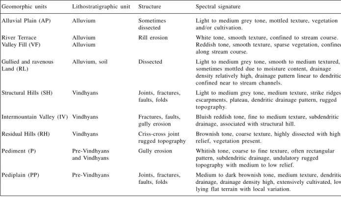
Table 1. Image characteristics of geomorphic units in Bundi-Indergarh area of Southeast Rajasthan
Geomorphic units Lithostratigraphic unit Structure Spectral signature
Alluvial Plain (AP) Alluvium Sometimes Light to medium grey tone, mottled texture, vegetation dissected and/or cultivation.
River Terrace Alluvium Rill erosion White tone, smooth texture, confined to stream course. Valley Fill (VF) Alluvium Reddish tone, smooth texture, sparse vegetation, confined
along stream course.
Gullied and ravenous Alluvium, soil Dissected Light to medium grey tone, smooth to medium textured,
Land (RL) sometimes mottled due to moisture content, drainage
density relatively high, drainage pattern linear to dendritic, confined near to stream channels.
Structural Hills (SH) Vindhyans Joints, fractures, Light to medium grey tone, medium texture, strike ridges, faults, folds escarpments, plateau, dendritic drainage pattern, rugged
topography.
Intermountain Valley (IV) Vindhyans Fractures, faults, Bluish reddish tone, fine to medium texture, subdendritic gully erosion drainage, associated with structural hill.
Residual Hills (RH) Vindhyans Criss-cross joint Brownish tone, coarse texture, highly dissected with high rugged topography relief, vegetation present.
Pediment (P) Pre-Vindhyans Gully erosion Whitish tone, coarse to fine texture, often rectangular and Vindhyans pattern, subdendritic drainage, undulatory rugged
topography with medium to low relief.
Pediplain (PP) Pre-Vindhyans Joints, fractures, Medium to dark brownish tone, medium texture, dendritic faults, folds drainage, drainage density high, extensively cultivated, low
lying flat terrain with local variation.
Table 2. Morphmetric parameters from Bundhi-Indergarh
S. No. Description Sub-basin Bundi Sub-basin Khatkar Sub-basin Gandoli Sub-basin Indergarh
1 Bifurcation Ratio (Rb)
Rb (1st/2nd) 3.80 3.41 4.37 3.93
Rb (2nd/3rd) 4.11 4.31 4.47 7.16
Rb (3rd/4th) 2.80 3.55 11.5 6.0
Rb (4th/5th) 3.00 4.5 2.0 ——
Rb (5th/6th) 3.00 —— —— ——
Rb (6th/7th) —— —— —— ——
Rb Average 3.31 3.92 5.02 5.68
Regression Coefficient 0.52 0.60 0.70 0.75
2 Basin Area (sq. km) 198 143.5 123.75 49.5
3 Basin Perimeter (km) 105 7 5 7 4 4 3
4 Basin Length (km) 14.5 2 4 27.5 18.5
5 Form Factor (Rf) 0.94 0.249 0.163 0.144
6 Circulatory Ratio (Rc) 0.22 0.32 0.28 0.33
7 Elongation Ratio (Re) 0.865 0.56 0.288 0.858
8 Drainage Density (km/km2) 2.95 3.76 2.90 3.28
9 Stream Frequency 2.83 4.54 4.68 4.42
1 0 Length of over land flow 0.168 0.13 0.17 0.15
1 1 Constant of Channel 0.33 0.27 0.34 0.30
climate with a virtually non-existent rainfall and comprises well compacted sedimentary rocks. The high drainage density of the watershed is attributed to rejuvenation of the area. The bifurcation ratio (Rb) for the area ranges between 2 and 11.5. The high Rb of the higher order streams point to structural controls, while the lower order streams (which show compara-tively low values of Rb) suggest a combined influence of tectonism and slope. The value of shape factor also indicates that the area is more elongated and is structurally controlled.
The morphotectonic parameters like longitudinal profile, psudo-hypsometric integral, valley height, width ratios and sinuosity indices were calculated and analyzed to make qualitative inferences on the nature of neotectonic activity along GBT and cross faults. According to Sinha (2001), the analysis of longitudinal profile, which is a graph of relationship between river elevation and river length is the most commonly used technique to identify river response to tectonics (Fig. 3).
The perturbations in the long profile are expected as a result of discontinuities in discharge and sediment load arising due to change in gradient vis-à-vis neotectonism. The longitudinal profiles for the watershed tributaries are highly concave upward suggesting that the headwa-ter area is tectonically very active. The gradient index values of Khatkar, Gandoli and Indergarh water shed streams are quite high (Table 3). Such highly variable gradient indices are typical in areas experiencing an in-termediate to high rate of uplift (Rhea, 1993). It is in con-formity with the field observations around Khatkar, where fault scarps and river terraces indicate the tectonic uplift. Psudohypsometric integral (PHI) is a numerical
method to describe the overall shape of the long profile (Rhea, 1993). PHI reflects the relative amount of deforma-tion and/or degradadeforma-tion that has occurred on each river. Valley incision is another measure that can be used to define relative upliftment (Bull and Mc Fadden, 1980). Cross-valley profiles are constructed from topographic maps. This index is defined as the ratio of width of the
1 5 10 15
Fig. 3. Longtudinal profile of the watersheds in Budhi-Indergarh area.
Table 4. Valley floor width and valley height ratio of Bundi-Indergarh
Watershed River Elev. PHI Average Ave.grad. length (m) (%) gradient index
(km) (m/km) (m/km)
Bundi 38.9 520 24.16 36.13 14.63
Khatkar 22.8 400 66.12 74.46 19.44
Gandoli 32.375 420 21.70 44.91 4.93
Indergarh 22.925 460 16.00 132.11 32.42 Table 3. Longitudinal profile parameters of the Bundi-Indergarh
Seg, No. Bundi Khatkar Gandoli Indergarh
1. 0.026 0.0125 0.004 0.005
2. 0.031 0.0018 0.0071 0.006
3. 0.015 0.0047 0.0078 0.003
4. 0.005 0.004 0.017 0.002
5. - 0.0062 0.009 0.004
6. - 0.0126 0.019 0.006
7. - 0.004 0.015
-15
Table 5. Values of sinousity parameters calculated for different segments of Bundhi-Indergarh area
Seg. No. AL CI VI SSI* HIS** TSI***
Bundi
1. 9 1.277 1.222 1.045 19.85 80.14 2. 9.5 1.242 1.210 1.026 13.22 86.77 3. 1 3 1.230 1.215 1.012 6.52 93.47 4. 1 0 1.30 1.25 1.04 16.66 83.33 5. 1 2 1.166 1.125 1.036 24.69 75.30 6. 1 4 1.214 1.178 1.030 16.82 83.17
Khatkar
1. 1 0 1.2 1.2 1.00 0.00 100
2. 10.0 1.22 1.2 1.016 9.09 90.90 3. 10.5 1.12 1.095 1.022 20.83 79.16 4. 1 1 1.18 1.136 1.038 24.4 75.55
Gandoli
1. 7 1.285 1.142 1.125 50.17 49.82 2. 1 0 1.40 1.4 1.00 0.00 100 3. 1 0 1.70 1.50 1.133 28.57 71.42 4. 1 0 1.20 1.20 1.00 0.00 100 5. 10.4 1.346 1.298 1.036 13.87 86.12 6. 1 0 1.2 1.18 1.016 10.00 90.00
Indergarh
1. 10.5 1.238 1.190 1.04 20.16 79.83 2. 10.5 1.285 1.238 1.037 16.49 83.50 3. 1 0 1.26 1.20 1.05 23.07 76.92 4. 7.5 1.413 1.333 1.060 19.37 80.62
* Slope Sinuosity Index, ** Hydraulic Sinuosity Index, *** Topographic Sinuosity Index.
valley floor (Vfw) to the height of the right and left di-vides with respect to the elevation of the stream channel measured at one site along the stream. Instead several values were determined along the length of streams in each sub-basin (Table 4).
The sinuosity parameters have been used to understand the role of tectonism (Rachna et al., 2004). Whereas, Muller (1968) included the role of topographic factor in the com-putation of sinuosity indices. Hydraulic sinuosity index is also computed to show the role of climate, but the topographic index is extremely important as it includes the component of tectonism, which can lead to the modi-fication of slope and topography. Various sinuosity indi-ces are calculated for different segments of the Mej river basin (Table 5). The Topographic Sinuosity Index (TSI) is found to be consistently dominant throughout the four watershed rivers. Abrupt increase in TSI values is seen in the uplifted blocks. This suggests that the topographic relief provided by differential movements along cross faults have played a major role in the drainage evolution of the area.
This study has helped in deciphering the impact of the recent tectonic activity in the Mej river basin of southeast Rajasthan. It suggests that the latest phase of tectonic ac-tivity took place mainly along GBT and cross faults during recent times. The lineament analysis suggests that the drain-age is controlled by cross faults. The long profiles of the four watershed streams show a high degree of tectonic
activity in the source region. The observed differences in the ranges of PHI in sub-basins could be related to complex tilting in the area. If aggradations in the lower reaches oc-cur more rapidly than incision in the upper reaches, the PHI would be lowered. The Gandoli and Indergarh sub-basins indicate minimum PHIs, which define the northward upliftment. The recent vertical movement of different fault blocks in Bundi-Indergarh sector is also expressed by the distribution of ravine lands and the rejuvenation of the Mej river (Jain, 1999). The valley floor ratio is very low indicat-ing, channel down cutting vis-a-vis ground uplift. Abrupt gradient changes and breaks in the longitudinal river pro-files indicate slope retreated lithologic heterogeneity and most importantly recent fault movement.
Conclusion
The profile parameters of the part of Mej river basin indicate the presence of several neotectonically active sub-blocks, which define horst and graben structures. The Bundi and Khatkar sub-basins belong to one block that indicates subsidence. The other block includes Gandoli and Indargarh sub-basins that are uplifted block. Near Khatkar, there is an abrupt change in the trend of strike ridges indicating a fault control, which is further confirmed by the course of the Mej river. The lineament through which the Mej river crosses the Vindhyan range appears to be a significant fault, that separates horst and graben structures in the area.
In general, the Bundi-Indergarh sector seems to be af-fected by a rotational movement with sinistral sense of shear. This interpretation is further confirmed by the S-shaped strike disposition of the Vindhyan rocks. The present study provides an example for application of morphotectonic studies in deciphering the neotectonic activities in the Bundi-Indargarh sector of southeast Rajasthan. This study further indicates that a systematic morphometric and morphotectonic appraoch may be used as a tool for outlining the regions of present day ground instability, which may have far reaching applications in land use planning.
Acknowledgement. B. Naveen and J. K. Jena are thanked for their assistance. Financial support for this work, pro-vided by Indian Space Research Organization is also gratefully acknowledged.
References
Bull, W. B; Mc Fadden, L. D. (1980) Tectonic geomor-phology north and south of the Garlock fault, California. In: Geomorphology in Arid Regions. D.O. Doehring (ed.), Allen and Unwin, London, 115-138. Heron, A. M. (1953) The geology of central Rajputana.
Mem Geol. Surv., India.
Jain, S. (1999) Some aspects of morphometric character of the Udyain river basin, Bundi district, Rajasthan. 12th Indian Geological Congress, Udaipur, 79 (1). 389.
Cent. Adv. Stud. Geol., Punjab University, Chandi-garh, 7, 151-152.
Lillesa, T. M; Kiffer, R. W. (1979) Remote Sensing and
Image Interpretation. John Wiley and Sons., New
York, 712.
Muller, J. E. (1968) An introduction to the hydraulic and topographic sinuosity indexes. Annals, Asso. Am. Geogr., 58, 371-385.
Rachna, Raj; Mulchandani, N; Bhandari, S; Maurya, D.M; Chamyal, L. S. (2004) Channel shifting of a highly sinuous meandering river in alluvial plain, Vishwamitri river, Mainland Gujarat. Current Science,
86 (2), 1647-1653.
Rhea, Susan (1993) Geomorphic observations of rivers in the Oregon coast range from a regional
reconnais-sance perspective. Geomorphology, 6, 135-150. Roy, A. B. (1988) Stratigraphy and tectonic framework of
the Aravalli Mountain Range. Mem. Geol. Soc. India, Bangalore, 7, 3-31.
Sinha, S. R. (2001) Neotectonic significance of longitu-dinal river profiles: An exampal from the Banas drain-age basin, Rajasthan. J. Geol. Soci. India, 58, 143-156.
Verma, P. K. (1996) Evolution and age of the Great Bound-ary Fault. In: Recent Advances in Vindhyan Geo-logy. A. Bhattacharyya (ed.), Geol. Soc. India, 36, 197-212.