Available online at www.sciencedirect.com
Procedia Computer Science 00 (2018) 000–000
www.elsevier.com/locate/procedia
The 10th International Conference on Ambient Systems, Networks and Technologies (ANT)
April 29 - May 2, 2019, Leuven, Belgium
Beacons positioning detection, a novel approach
Francisco Morgado
a, Pedro Martins
a,∗, Filipe Caldeira
aaPolytechnic Institute of Viseu, Dep. of Computer Sciences, Viseu, Portugal
Abstract
Recent Bluetooth Low Energy (BLE) beacons provide new opportunities to explore positioning. Beacon positioning determination using current approaches is supported by pre-calculated formulas, for generic beacons, whereas the position can be accurately estimated with a low error up to a small distance; or based on fingerprinting the signal for the given space. In both cases, the accuracy variate depending on hardware specifications and other conditions such as beacon brand, wrap material, temperature, wind, location, surrounding interference, battery strength, among others.
This paper introduces a method for beacon-based positioning, based on signal strength measurements at key distances for each beacon. This method allows for different beacon types, brands, and conditions. Depending on each situation (i.e., hardware and location) it is possible to adapt the distance measuring curve to minimize errors and support higher distances, while at the same time keeping good precision. Moreover, this paper also presents a comparison with traditional positioning method, using formulas for distance estimation, and then position triangulation. Performed tests took place at the library of the campus of the Polytechnic Institute of Viseu.
Experimental results show that the proposed position technique has 13.2% better precision than triangulation, for distances up to 10 meters.
c
© 2018 The Authors. Published by Elsevier B.V.
This is an open access article under the CC BY-NC-ND license (http://creativecommons.org/licenses/by-nc-nd/4.0/) Peer-review under responsibility of the Conference Program Chairs.
Keywords: Beacons; indoor location; Bluetooth; BLE; architecture; distance; position; precision.
1. Introduction
Applications strictly based on location detection, impose challenges when the location is performed indoors, mainly because of the absence of GPS signal, and because of the challenges that positioning pinpoint based on other networks signals bring. The main purpose of knowing such location is to offer useful information to different types of users (e.g., elevators promotions, bathroom locations, wet floor warnings) and guide instruction (e.g., emergency evacuation, or help people with special needs).
Present methods using BLE to determine position involve placing a large number of simple BLE beacons at known
∗Corresponding author.
E-mail address: [email protected]
1877-0509 c© 2018 The Authors. Published by Elsevier B.V.
This is an open access article under the CC BY-NC-ND license (http://creativecommons.org/licenses/by-nc-nd/4.0/) Peer-review under responsibility of the Conference Program Chairs.
locations. Beacons can be spread in a city, along roads, or indoors. Then mobile devices “sniffs” for known signals from the beacons, and measures the received signal strength. The relative link quality between the beacon and the mobile device is used to determine the location of the mobile device using mathematical formulas. As strongest the signal is, the closest the beacon is regarding the mobile device. Based on that beacon (or weighted average of several nearby beacons) which produces the strongest signal, the location can be estimated. The advantage of beacon-type systems is in the simplicity and low cost of implementation. The disadvantage of beacon-type systems is that they typically provide poor quality location estimation, in most case studies location is only acceptably accurate up to 3 meters distance [5] [15].
In all possible scenarios related to location pinpointing, an inaccurate location can lead to dangerous situations (e.g., inaccurate stairs detection) and serious consequences.
Since a couple of years ago, a relentless market explosion of mobile devices, like smart-phones, attracted endless applications and services in business and infotainment. All this information relies on location and mobility. Many academic [4] [18] [21], articles propose techniques based on the mathematical formulation to calculate the distance. However, the distance estimation depends on many variables that cannot be accounted using these methods, for in-stance: different hardware’s have different behaviors; the wrapping material surrounding the beacon affects the signal strength; winds; electronic interference; battery power level; and many others.
This paper proposes a signal distance measuring technique dedicated to each beacon. For each device, the respective distance curve is determined. This way distance measurements have the lowest error possible, even if there are signal reflections. Then battery power attenuation over time is also accounted. All data is treated and stored in a database. This data is then used to feed each device with the signal power measurements vs. distance, for each beacon in range. To minimize errors, data is collected in pre-set locations. This way even if objects are interfering with the measures, the location will be precise. For this porpoise, a communication architecture, a mobile app, and a database server, were developed and tested.
Results show that the proposed method in this paper is 13.22% better than the traditional triangulation of signals, which does not ponder the beacons that are more near.
This paper is organized as follows. Section2, states the motivation that leads to this work, as well as, the main contributions. Section3, resumes the related work in the field of Bluetooth beacons oriented to position determina-tion. Section4, describes the developed architecture and, Section5, describe the algorithms to support the proposed method. Section7, compare the proposed method with the traditional signal triangulation. Finally, Section8, conclude the developed work and introduce future work guidelines.
2. Motivation and contributions
This work is mainly motivated by the need to support the development of an app able to accurately determine the indoor location of key points and obstacles, mainly oriented to improve the mobility of special needs individuals. BLE is used as it is demonstrated to be a successful and widely deployable indoor technology with great potential for localization systems. This technology can be easily deployed, imposing low power consumption and low-cost infras-tructures. To the best of our knowledge, there are no work comparing different approaches to extend and minimize the positioning accuracy, when using only BLE technology.
This work contributes to a new communication strategy to gather beacons positions and space awareness; A prob-lem and solution formulation, that can be adjusted to different scenarios; Comparison between different approaches; Finally it is proposed a improved approach with better precision for position detection.
3. Resumed related work
Position detection is already a popular research field where many approaches and technologies can be found, each one with comprehensive overviews [1] [14] [16]. Special relevance is given to BLE positioning fingerprinting, that avoid complex models that require a pattern match with previously surveyed radio strengths mapped signals, as happens with WiFi signals [2] [11] [13] [20]. Nevertheless, these techniques have been initially developed for WiFi technology and later adapted to BLE.
[19], and, fingerprinting [6] [19] [17]. Although there are important limitations, one of them is the necessary time for a device to search and find close Bluetooth beacons, in the worst case scenario takes 11 seconds, while during that time the user can travel more than 15 meters. As a consequence, positioning using classic Bluetooth was not adopted. With BLE the classic Bluetooth latency issues are no longer present. The BLE standard incorporates the concept of “micro-location”, which is nothing more than a proximity technique [3].
Another path in fingerprinting literature combining WiFi fingerprinting with other sources, based on the idea of Simul-taneous Location and Mapping (SLAM), applied to pedestrian location prediction [7] [12] [10]. In SLAM automatic search is exploited with machine learning techniques, to correct the user’s path during navigation. This approach makes use of Gaussian Process regression to estimate signal maps from discrete WiFi RSS information. [8].
4. Architecture
The first phase of the positioning process is implemented on top of a smart-phone app, which is used to measure the BLE signals strength at precise given distances (x and y-axis) and store this information in a cloud database server. Bluetooth context-aware sources, which are trying to estimate their position, perform periodic querying to the database containing the reference position measurements. Each query results on a list of Bluetooth signal that was visible at the given queried range.
Bluetooth reference beacons consist of fixed sensors at known positions. The target device (i.e., for instance, a smart-phone), has no a-prior location information of itself. It is the task of the proposed positioning system to estimate the location of the target device, based on available beacons signals, and compare the measurements with the pre-measured beacons signals fingerprints.
There is no homogeneity between the target, mobile devices. However, all beacons are of the same type.
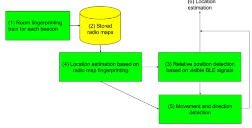
Fig. 1. System architecture
In Figure1is described the communication process between trained data, stored in a database, and the position de-termination, performed by the mobile device. On (1) the room(s) available signals are fingerprinted with the objective to train the signal vs. distance from/to each known fixed position beacon. For instance, collected measures include a real position on X; real position on Y; Z, representing the floor level (used to ignore other floor beacons); signal strength. This measurement process is repeated for several different distances/positions from the given beacon. Figure 1(2), represents the storage mechanism, AKA database, which is used to store trained information and feed it to the target devices that are trying to determine their position. Based on the relative position detection, Figure1, (3) and (4) enquirer the database for location information based on the visible beacons signals, with this information a location is estimated (6). The same process is performed, with configurable frequency (by default each second), if the movement is detected, i.e., the target device is moving along the mapped area.
Fig. 2. Example, beacons distance 5. Algorithms
Traditionally the distance from the beacon measuring is given by an expression similar to:
d = 10(P−RS S I10n ) (1)
Where, in Equation1, n ranges between 2 to 4, and it is used to adjust the signal pondering. Then, RSSI represents the measured signal strength. Usually, this value is negative and is always changing. In the formula, P is the TxPower which beacons are transmitting as part of the package and RSSI from the beacon device. The most common value of P is 2 − 2.5.
Never the less the distance accuracy is quite “unstable” and with large variations. The values variation can be miti-gated by collecting a few values over time and use the average, with a low standard deviation. Another issue is the interference.
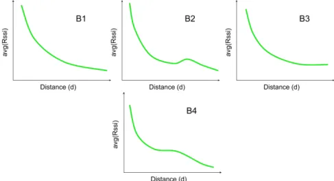
In this paper, is proposed a different method to determine position. Let’s use as an example the distances in Figure 2, where P is the actual position, B1 to B4 are beacons, and d1 to d4 are the distances.
First step. For each beacon (Bi), at a given distance (e.g., 1 meter, 2 meters, etc.), the RSSI values are collected using different exposure times (i.e., 10 seconds, 30 seconds, 60 seconds, 120 seconds), and the average of the averages is calculated. This process is repeated for different distances. By doing so, for each beacon, the charted RSSI distance curve of the beacon is created (with a minimum standard deviation), and stored into a central database. Note that, even if a beacon is suffering interference, that is accounted in the distance calculation, overcoming a limitation in Equation 1.
Figure3, shows some examples of charted measures that can be obtained from the proposed fingerprinting method. However, these show some distance measuring problems and concerns. How to ponder, more or less a measured distance, to make it more accurate? For instance, B1 and B4 should have more weight on the distance measurement, since they are more near the position P. How to overcome multiple different reads for different distances (mostly due to interference noise in the signal)? The B2 and B4 represent equal RSSI measures that reference two different distances.
Second step. Ponder the measured distances accordingly with the position Pos to the beacon. The main objective is to consider that a near distance beacon has more weight on the position determination than a further distance beacon. Based on that, determine the x, y, z, current position.
Pos(x,y,z)= N i=0 Bi(x,y,z)× Pi N i=0Pi (2)
Equation2, is used to give the positioning coordinates in x, y, z, referential. Where, Pos(x,y,z), represents the position
on the given referential. Bi(x,y,z) is each beacon position in x, y, z. The P, represents the ponder for each measured
distance. Pi=d1
Fig. 3. Example charts (RSSI, distance)
Each beacon ponder, Pi, is represented by the inverse of the distance, di, to each beacon.
Pos(x,y,z)= N i=0 Bi(x,y,z)×d1i N i=0d1i (4) Therefore, the equation to determine the position, Equation3, evolves to Equation4. However, there is the need to be able to modify how each measured distance will be pondered when the position is being estimated.
Pi= 1
A + dB i
(5) Equation5, introduces values A and B that can variate as needed to ponder the distance, depending on how far or near, in relation to the current position, each beacon is.
Pos(x,y,z)= N i=0 Bi(x,y,z)×A+d1B i N i=0A+d1B i (6) This way the final positioning equation, with pondering, takes the form represented in Equation6. So, even if for a given beacon the charted curve is not the most correct at a given distance, adjusting A and B is possible to give more or less weight to the measurements obtained by a given beacon.
Considering the Char B1 represented in Figure3, with represented Equation6, it is possible to give more relevance to a distance of a given RSSI, or vice-versa, as represented in Figure4.
Third step. When analyzing Figure3, chart B2 and B4, for different distances the same Rssi was measured. This happens because of signal interference’s and reflections. This issue is overcome by keeping a historic window of the dislocation. So, if for a given Rssi the distance measures point to {d3,d4,d5} the the past information will help deciding
the next distance position. Based on previously measured values, d0,d1,d2,{d3,d4,d5}, the next logical position will
be d3.
Based on proposed methods, Figure2, B4 and B1 have more importance/relevance (because they are more near P), than B3 and B2 (which are further from P).
6. Experimental method
To evaluate the performance of the proposed solution were performed two different types of tests in the library of the Polytechnic Institute of Viseu, Portugal. First using the proposed method, based on pre-trained signals fingerprints
Fig. 4. Example charts, pondering effect
Fig. 5. Library floor layout, with beacons
for different distances. In the context of this proposal, queries were set to execute with a fixed size of results, 100 rows per beacon, and fixed time intervals, every 1 second. The second test was performed using signal triangulation of the three (or more) most powerfully beacons signals.
The space used for testing had two large rooms, one per floor, each with approximately 400 square meters, with a circular shape. Eight beacons were distributed in the room as shown in Figure5, marked with green circles, letters A to H. At the bottom and top of each stair, we located a beacon aiming to help determine a position in axis Z. The Z-axis allows to ignore the upper and lower floor beacons signals, and consider only the ones within the present floor. Marked with red color, letters P1 to P5, are the user positions, which were used to perform the positioning tests. The training process of the proposed positioning method consisted of fingerprint measurements of the distance to each beacon, variation +1 meter, for each iteration, around the beacon.
All beacons devices were of the same type and brand, Estimote. Note that: standard deviations for the trained mea-surements were minimized as much as possible for each beacon so that the training accuracy approaches 1.
For comparison purposes, the traditional triangulation method is also used. The distance to each beacon (minimum 3) is calculated using Equation1, the circumferences are calculated, and finally, their intersection coordinates represent the measured location.
7. Evaluation analysis
The experimental evaluation compares the proposed positioning method, versus, the traditional triangulation based on the distance to the beacon from positions P1 to P5 (Figure5.
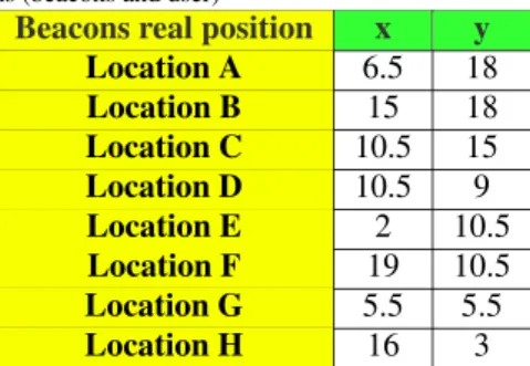
Table 1. Real positions (beacons and user)
Beacons real position x y User real position x y
Location A 6.5 18 Location P1 7 13 Location B 15 18 Location P2 16 15.5 Location C 10.5 15 Location P3 13.5 10 Location D 10.5 9 Location P4 5.5 8 Location E 2 10.5 Location P5 13.5 5 Location F 19 10.5 Location G 5.5 5.5 Location H 16 3
Table 2. Proposed method, experimental results, positioning and precision
Proposed method Precision
x y x y Location P1 7.6 12.8 91.4% 98.5% Location P2 15.9 16.1 99.4% 96.1% Location P3 13.1 10 97.0% 100.0% Location P4 5.4 7.8 98.2% 97.5% Location P5 13.3 5.1 98.5% 98.0% AVG accuracy: 96.9% 98.0%
Table 3. Triangulation, experimental results, positioning and precision
Triangulation method Precision
x y x y Location P1 5.4 11.7 77.1% 90.0% Location P2 15 17.6 93.8% 86.5% Location P3 10 12.8 74.1% 72.0% Location P4 5.2 8.4 94.5% 95.0% Location P5 11 3.9 81.5% 78.0% AVG accuracy: 84.2% 84.3%
In Table 1is shown the real position in the axis x and y of the beacons position (beacon A to H) and the user positions (P1 to P5). P1 to P5 locations were used to determine the position of the user using the proposed positioning method, and with the triangulation method.
Table2shows the position, for P1 to P5 locations, using the proposed positioning method. Positioning precision averages 97.5% which we consider an excellent precision. In the case of the proposed method, the beacons act as an analogy to magnetic fields, the nearer Px is from the beacons, the more relevant for the positioning determination it will be (i.e., there is a more significant attraction), resulting on more relevant information for the positioning determination. Table3, shows the experimental results using the traditional triangulation methods (i.e., interception of circumfer-ences). Given this method, the global accuracy was 84.2%, which is good.
Comparing both methods to determine the position using Bluetooth beacons, the positioning method proposed in this paper is 13.2% better than the traditional triangulation of beacon signals.
8. Conclusions and Future work
In this work is proposed a new method to determine the position inside buildings where there is no GPS signal available. Using BLE beacons, the signals strength in different locations is measured and stored. Given the locating of the user, and detected beacons signal strength, the proposed method, ponders the available beacons signals to determine a precise location based on previously trained signals measurements.
Experimental results, comparing the proposed method with triangulation, show that the processed method was able to achieve 97.5% vs. 84.2% for the triangulation. An improvement of 13.2% of the average positioning precision. As future work, will be developed a mobile application to place the beacons on a given map layout, train the beacons signals at different distances, and based on gathered data determine the current position.
Acknowledgements
“This work is a result of the BlueEyes project, CENTRO-01-0145-FEDER-023797, 02/SAICT/2016, co-financed by CENTRO 2020, Fundac¸˜ao para a Ciˆencia e Tecnologia I.P (FCT), Portugal 2020 and European Regional Devel-opment Fund (ERDF). It was also supported by CityAction project, CENTRO-01-0247-FEDER-017711 (CENTRO 2020, Portugal 2020, ERDF) and by national funds through FCT, under the project UID/Multi/04016/2016.”
References
[1] K. Al Nuaimi and H. Kamel. A survey of indoor positioning systems and algorithms. In Innovations in information technology (IIT), 2011 international conference on, pages 185–190. IEEE, 2011.
[2] P. Bahl, V. N. Padmanabhan, and A. Balachandran. Enhancements to the radar user location and tracking system. Microsoft Research, 2(MSR-TR-2000-12):775–784, 2000.
[3] S. Bluetooth. Bluetooth core specification version 4.0. Specification of the Bluetooth System, 2010.
[4] S. S. Chawathe. Beacon placement for indoor localization using bluetooth. In Intelligent Transportation Systems, 2008. ITSC 2008. 11th International IEEE Conference on, pages 980–985. Citeseer, 2008.
[5] S. S. Chawathe. Low-latency indoor localization using bluetooth beacons. In Intelligent Transportation Systems, 2009. ITSC’09. 12th Inter-national IEEE Conference on, pages 1–7. IEEE, 2009.
[6] L. Chen, L. Pei, H. Kuusniemi, Y. Chen, T. Kr¨oger, and R. Chen. Bayesian fusion for indoor positioning using bluetooth fingerprints. Wireless personal communications, 70(4):1735–1745, 2013.
[7] R. Faragher, C. Sarno, and M. Newman. Opportunistic radio slam for indoor navigation using smartphone sensors. In Position Location and Navigation Symposium (PLANS), 2012 IEEE/ION, pages 120–128. IEEE, 2012.
[8] B. D. Ferris, D. Fox, and N. Lawrence. Wifi-slam using gaussian process latent variable models. 2007.
[9] F. Forno, G. Malnati, and G. Portelli. Design and implementation of a bluetooth ad hoc network for indoor positioning. IEE proceedings-Software, 152(5):223–228, 2005.
[10] R. Harle. A survey of indoor inertial positioning systems for pedestrians. IEEE Communications Surveys and Tutorials, 15(3):1281–1293, 2013.
[11] V. Honkavirta, T. Perala, S. Ali-Loytty, and R. Pich´e. A comparative survey of wlan location fingerprinting methods. In Positioning, Navigation and Communication, 2009. WPNC 2009. 6th Workshop on, pages 243–251. IEEE, 2009.
[12] J. Huang, D. Millman, M. Quigley, D. Stavens, S. Thrun, and A. Aggarwal. Efficient, generalized indoor wifi graphslam. In Robotics and Automation (ICRA), 2011 IEEE International Conference on, pages 1038–1043. IEEE, 2011.
[13] T. King, S. Kopf, T. Haenselmann, C. Lubberger, and W. Effelsberg. Compass: A probabilistic indoor positioning system based on 802.11 and digital compasses. In Proceedings of the 1st international workshop on Wireless network testbeds, experimental evaluation & characterization, pages 34–40. ACM, 2006.
[14] H. Koyuncu and S. H. Yang. A survey of indoor positioning and object locating systems. IJCSNS International Journal of Computer Science and Network Security, 10(5):121–128, 2010.
[15] A. LaMarca, Y. Chawathe, S. Consolvo, J. Hightower, I. Smith, J. Scott, T. Sohn, J. Howard, J. Hughes, F. Potter, et al. Place lab: Device positioning using radio beacons in the wild. In International Conference on Pervasive Computing, pages 116–133. Springer, 2005.
[16] H. Liu, H. Darabi, P. Banerjee, and J. Liu. Survey of wireless indoor positioning techniques and systems. IEEE Transactions on Systems, Man, and Cybernetics, Part C (Applications and Reviews), 37(6):1067–1080, 2007.
[17] A. Madhavapeddy and A. Tse. A study of bluetooth propagation using accurate indoor location mapping. In International Conference on Ubiquitous Computing, pages 105–122. Springer, 2005.
[18] F. Palumbo, P. Barsocchi, S. Chessa, and J. C. Augusto. A stigmergic approach to indoor localization using bluetooth low energy beacons. In 2015 12th IEEE International Conference on Advanced Video and Signal Based Surveillance (AVSS), pages 1–6. IEEE, 2015.
[19] F. Subhan, H. Hasbullah, A. Rozyyev, and S. T. Bakhsh. Indoor positioning in bluetooth networks using fingerprinting and lateration approach. In Information Science and Applications (ICISA), 2011 International Conference on, pages 1–9. IEEE, 2011.
[20] M. Youssef and A. Agrawala. The horus wlan location determination system. In Proceedings of the 3rd international conference on Mobile systems, applications, and services, pages 205–218. ACM, 2005.
[21] Y. Zhuang, J. Yang, Y. Li, L. Qi, and N. El-Sheimy. Smartphone-based indoor localization with bluetooth low energy beacons. Sensors, 16(5):596, 2016.