Title: Logistic optimization in tourism networks
Authors: Frias, Armindo (1); Cabral, João (2); Costa, Álvaro (3)
(1) ADVANCE-Advanced Research Centre in Management, CINAV-Naval Research Centre, ISEG/UTL-Lisbon School of Economics & Management, Lisbon, Portugal, [email protected].
(2) CIMA/UE-Research Centre in Mathematics and Applications of Évora University, UAC- Azores University, Ponta Delgada, Portugal, [email protected]. (3) Research Centre for Territory, Transports and Environment, FEUP- Faculty of
Engineering of the Porto University, Porto, Portugal, [email protected].
Abstract
Tourism is one of the activities with high benefits on the development and for many regions, enabling the integration of local populations and economies. In our natural laboratory, the Azores Island of São Miguel, an important share of tourists identifies adventure, leisure and touch with nature, as the main reasons for the visit. The use of footpaths can contribute to the satisfaction of tourists, promoting tourism and the region's development during their movements on the tourism network, tourists appreciate different types of attractions and need the support of a set of facilities.
Tourist decisions aren’t always done in a rational way, emotions add even more complexity to the human decision process. The movement of tourists within a destination depends on factors related to tourist characteristics, like the time budgets, preferences or destination knowledge, and destination features related to attractions characteristics or accessibility level.
The existence of a mathematical model that incorporates the main factors that explain the movement of independent tourists within a destination, in a dynamic way, will make possible the creation of an adaptable software tool. This tool will meet the specific needs of tourists, allowing the use of the network in an optimal way by the different tourist profiles, and the needs of regional government and business, allowing better decisions and the offer of relevant tourism products.
This article is based on the authors’ previous research and identifies the relevance of tourism for regional development, finds the main tourists’ mobility criteria on the study territory, using as main support the footpath network, recognises the necessary modelling process and develops the foundation for the building of the mathematical model that explains the movement of tourists within the destination, making possible a future adaptable software tool.
1. Introduction
Tourism is a complex activity that incorporates multiple stakeholders and socioeconomic factors. We can identify stakeholders from the private and public sector, singular and collective, service providers and consumers, with direct or indirect involvement. Between them, these different types of relationships are carried out over time and space. When we study this sector, we can only conclude that tourism is a network of enormous complexity that describes behaviours, actions and decision-making from its stakeholders and the different relationships established among them. A network event is never an isolated thing, it is always influenced by the players’ characteristics, the kind of relationships established among them and the surrounding context. But in turn, the event will influence stakeholders and the relationships that are established in their neighbourhood. Beyond great complexity, tourism is also a dynamic network system. Being the networks theoretical construct adapted to the analysis of complex problems with many variables interconnected in a dynamic way, it is suitable to study tourism activity in multiple approaches.
The main advantages of studying tourism with the networks approach refers, according to Dredge (2006), to the ability to analyse the event of a phenomenon in several distinct networks and the interconnection among them. The same author considers that there can be different political decisions affecting a network and that the players can interact and perform different roles in different networks. This position enlarges the tourism study perspective to the existence of multiple parallel networks superposed at multiple levels and with the existence of different interactions among them. This idea is the basis for the initial construction of our model. The importance of tourism to the national and regional development, in its different forms, is recognized by many studies. The Azores region is no exception, quite on the contrary, since it integrates the specificities of an island located at the outermost territory of Europe.
The existence of footpaths can be an important instrument in tourism development, particularly in green sustainable tourism. Footpaths are an important tool to promote environmental and social education, encouraging the observation and improving the knowledge about nature and endorsing greater respect for our heritage. The fact that footpaths lead people in rural areas, contributes to the socioeconomic development of that area, minimizing human desertification and giving benefits to a set of different support facilities like eating and accommodation places (Braga, 2006) (Midmore, 2000). We can say that footpaths are an important factor for the tourism activity and to the development of many regions.
The understanding of the tourist movement within a destination has significant consequences for the tourism product improvement, allowing local stakeholders to develop a customized offer better to the different needs of tourists (Zoltan & McKercher, 2015). To realise the use of footpaths, we must identify the factors that influence the mobility of tourists in the region. From the literature analysis, the mobility associated with the tourist movement has been widely investigated, but the mobility in intra-destination movement denotes some scarcity of study (Mckercher & Lau, 2008). As mentioned by Kitazawa and Batty (2004), there is a clear need to develop new models that can explain the movement of pedestrians.
The choice of the São Miguel Island territory to carry out this study is due to the combination of several factors associated with the unique characteristics of the region, in particular the fact that the territory integrates a large number of natural, social and cultural attractions, the fact that the population is disperse all around the territory, deprived of human deserted places, and the high level of security in the region. These features allow tourists to walk freely through the territory, according to their preferences, in iteration with local populations. Another element relates to the advantages that isolated territories, including islands, have to carry out scientific studies, providing scientists the delimited ideal microcosm to conduct their studies, with high levels of success in the past (Baldacchino, 2008) (Deschenes & Chertow, 2004).
Based on the authors’ previous research (Frias & Cabral, 2013) (Frias, Cabral, & Costa, 2014) this article is aims to identify the theoretical bases that allow to carry out the mathematical modeling of the movement of tourists in the area under study. Through this model it will be possible to create computer tools that improve tourism in that territory, and in parallel provide the development of the region as a whole. This study is organized as follows: section 2 presents the importance of tourism to the regional development; section 3 characterizes the existent footpaths in the area, checking their relevance for local tourism; section 4 analyses the movement of tourists, identifying the main factors that influence their decision-making process in the choice of sites to visit; section 5 analyses the application suitability of the networks theoretical field to study tourism; section 6 presents the mathematical modelling process; section 7 describes the conducted empirical study, including the data collection process and identifies the model basic structure; section 8 explains the basis for the model; finally, section 9 will present same closing thoughts.
2. Relevance of tourism for regional development
The movement of tourists around the world represent the largest displacement of human beings outside their usual environment. This campaign strongly affects local, regional, national and 3
international economies (Miguéns & Mendes, 2008). Tourism is one of the most important economic activities worldwide, playing a great role in the economies of many countries and regions (Baggio, 2008). In this sense, the Organisation for Economic Co-operation and Development (OECD) report "Trends and Tourism Policy 2014" (OECD, 2014), considers tourism as an important economic activity in OECD countries, it represents 4.7% of the Gross Domestic Product (GDP), 6% of the employment and 21% of the services exports, in 2012. In Portugal’s case, tourism represents 9.2% of its GDP.
But tourism doesn’t only have great importance in economic evaluation. Crouch and Ritchie (1999) identify a set of economic, social, physical, psychological, cultural and political positive impact. According to Bernardo Trindade (Turismo de Portugal IP, 2011), tourism plays a central role in the Portuguese economy, being the leader in exports, sustainability, innovation and job creation. Because of its characteristics, tourism is like no other activity in correcting asymmetries, creating jobs and is one of the main drivers of regional development in Portugal. Tourism, in addition to the large number of players, integrates a high complexity due the wide range of stakeholders and the fact that is not possible to identify unequivocally its boundaries (Costa & Baggio, 2009).
Now, it’s important to define some basic concepts like tourist destination, tourism product and point of interest. Tourist destination refers to a set of economic, cultural and social activities, complemented by a set of support infrastructures, which, as a whole, are understood as a product offered to attract tourists (Beerli & Martı́n, 2004) (Shih, 2006). It states to a complex and adaptive system of different companies and organizations that manage different services and attractions, to be offered to a visitor (Costa & Baggio, 2009).
Tourism product has been studied from both the supply and demand point of view. It refers to a very complex good that contains a set of surrounding factors and support facilities to provide a status-enhancing experience to tourists. Surrounding factors can be political or legal, technological, environmental, economic, cultural or social. Support facilities refer to shopping, recreational and attraction events, travel support, eating places (restaurants and similar), accommodation and transport (Murphy, Pritchard, & Smith, 2000).
The perceived pull motives to choose a destination to tour are facilities, core attractions and landscape features. Since tourists may have previous detailed information about the destination, they want to have not just landscape features but a tourist service that includes core attractions and support facilities (Correia, Valle, & Moço, 2005). The importance of facilities to support tourism is reinforced by several authors. In this line of thought Khadaroo and Seetanah (2007) argue that it isn´t possible to develop tourism without ensuring the existence of transport
infrastructures that enable access and movement of tourists in the territory, such as the existence of airports, seaports and roads. Another development element relates to the availability of a set of basic infrastructure, such as electric, sewer, fresh water, communications, health services and security.
Tourist attraction, tourist sites or point of tourist interest, refer to places, events or buildings that tourists usually visit. As can be seen, the tourism attraction is closely linked to the tourist product. When tourists select a destination, as a rule, do not do it just for a reason, but by a set of experiences. So, the tourist product should integrate a range of different tourist attractions or sites, located in a specific place or region, to provide new experiences to tourists.
The multi-destination tourism allows tourists to customize their experience, giving them freedom of movement in search for different attractions, allowing the optimization of their experience and getting in touch with local populations (Shih, 2006). The development of tourism based on the walks, especially in rural areas, has huge potential to create economic and social benefits, contributing to rural and regional development (Howley, et al., 2012).
Regarding the Azores Islands, it is a tourist destination that, despite the recent democratization of air transport, it’s still penalized by the cost of transport to access the region. It’s possible to perceive a growing concern to develop natural and cultural attractions to specific tourism markets, such as golf, surf, pedestrian paths or religious tourism.
3. Contribution of footpaths to the island tourism
The walking tour through the territory provides great interaction with the local population, especially in rural regions. Rural tourism associated with footpaths incorporates several advantages: (1) allows tourists to go deeper in rural and low population density areas; (2) helps the contact with nature and provides an enriching experience of enjoyment and civic education; (3) can be performed almost throughout the year, despite having greater compliance with the warm months and being inadvisable in short periods of hard winter meteorological conditions; (4) assumes a low impact on the landscape and does not involve, as a rule, mass movement; (5) provides additional income to farmers and small rural entrepreneurs; (6) provide greater economic impact on the region, in the sense that the revenues remain in local economies for longer (Midmore, 2000) (Howley, et al., 2012). The ability of people to access nature areas can also have a negative impact on the conservation of soils, water, vegetation, fauna and geological formations in the existing trails and in its surroundings, contributing also to waste disposal and forest fires (Braga, 2006).
Being the Azores an ultra-periphery territory of Europe, with a strong tourist image, linked to nature and social-cultural traditions, the regional tourism politics must reinforce the bet on non-intrusive tourism that does not change the fragile ecological and social balance of the region. Because of the main advantages described above, rural tourism associated with walking activities can provide sustained economic development of the region. The existence of footpaths allows tourists to get to know the region and is an important factor of tourist attraction. Despite the advantages associated with their existence, its use doesn’t invalidate the need to take the necessary measures to limit the negative impact that comes with it.
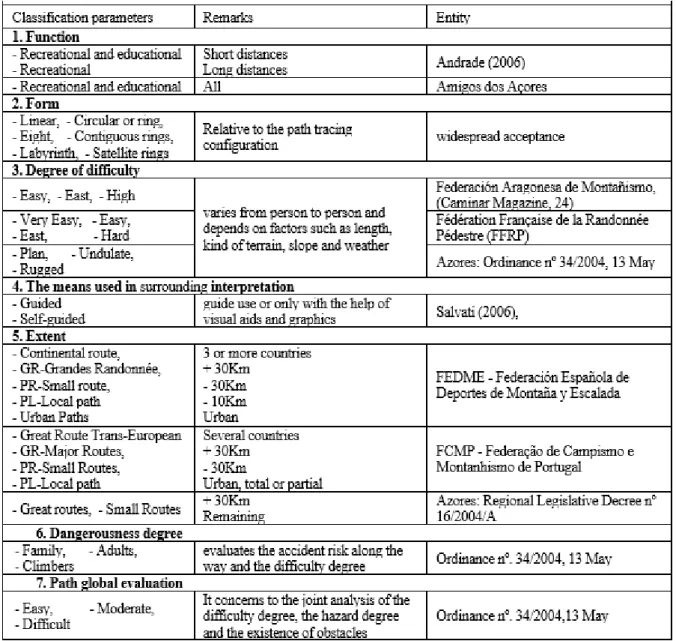
After seeing the advantages and risks associated with footpaths, we will now detail the main features of walking trails. We built table 1 that summarizes the main classification of the walking trails.
Table 1: Summary of the walking trails classification
Based on existing data in Braga (Braga, 2006) 6
Regarding the existing walking trails in the Azores, we chose to use the features accepted in that territory. It is considered that all paths play a recreational and educational function and take the most diverse shapes and degrees of difficulty. Despite the diversity, the prevalence is on linear paths and undulating difficulty (moderate). All of them have an extension that classifies them as small route. The surrounding interpretation is usually done without a guide and with reduced help from visual means.
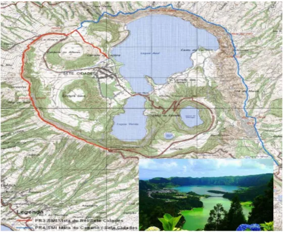
In the present study, we could identify, on the São Miguel Island, 51 walking trails with different denominations, for a total of 294,6Km. Among these, 22 are certified by the Regional Government as official pedestrian paths. Figure 1 gives an example of a classified pedestrian path, the “PR3SMI Vista do Rei - Sete Cidades”, that may be classified as: (1) function - recreational and educational; (2) form - linear; (3) degree of difficulty - plan; (4) means used in surrounding interpretation - depending on the use; (5) extent - small route (7Km); (6) dangerousness degree - family; (7) path global evaluation - easy.
Figure 1: Pedestrian path “PR3SMI Vista do Rei - Sete Cidades” in http://trilhos.visitazores.com
4. Factors that influence tourists movement
Now, we intend to analyse how and why tourists move in a given region, i.e., the reasons that lead tourists to select a particular tourist site over another and identify their mobility patterns within a tourist destination.
The tourist decision-making process have two different phases, namely: (1) a previous travel planning, to define the destination and the general trip parameters; (2) a travel modification, during the journey to adjust and defines the details (Bansal & Eiselt, 2004). In both cases, there are a large number of factors that influence the tourist destination attractiveness. Those factors can be divided into two main components, the ones related with tourist site attributes and factors related to the tourist intrinsic condition.
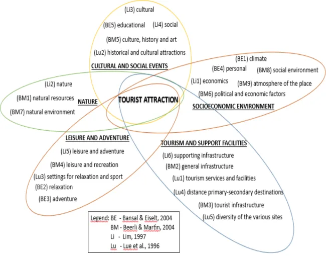
Although this study is centred on the movements within a destination, for better understanding the issues that influence it, it’s essential to identify the factors that affects the decision making practice to choose a destination. According to Lau and McKercher (2007) the factors related with the human condition push the tourists to the destination and the physical site conditions pull the tourists. There are many factors that can influence de choose a destination, each studded author had synthetize them in different categories. In order to summarize them, it was compiled by the authors the main categories factors that influence tourist destination attraction, in figure 2. Each one of the five categories that we found can be related to tourist condition or physical conditions but, nature and cultural and social events are more related with tourist sites, leisure and adventure to the travel motivations, socio-economic environment and tourism and support facilities to the physical conditions.
From the analysis of the previous factors and their relationship with the footpaths, we can say that exists a strong connection between them, namely: (1) socioeconomic environment, because it is an activity that doesn’t involve a significant financial spending and contributes to the civic formation; (2) nature, by allowing direct contact with nature in a sustainable way; (3) cultural and social events, for providing the close relationship with the local population, thus enabling a strong iteration with the cultural and social local events; (4) leisure and adventure, the different paths allow a multitude of new experiences and a sense of relaxation; (5) tourism and support infrastructure, of which the tourists are dependent such as accommodation, food and transport routes. Considering that footpaths have a direct connection with the main factors of tourist destination attractiveness, it may be assumed that the footpaths have an influence on regional tourist attraction.
Figure 2: Factors that influence tourist attraction
Our composition
Looking now for the movement of the tourists within a destination and factors that influence
their movement, it turns out that only a small share of world tourism is done to meet a specific interest (Deng, King, & Bauer, 2002). In this sense the tourist tends to seek different experiences, meet different kinds of attractions. In this regard, Lue et al. (1996) conclude that tourists are more likely to choose a multi-attraction circuit, where there are secondary tourism attractions from a different type, compared to the journeys that have similar secondary destinations.
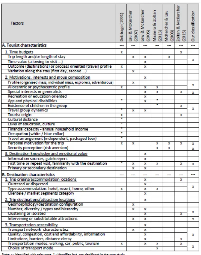
Considering that classify tourist attractions allows to categorize, evaluate and compare the various possible choices, helping tourist with the task of deciding (Filieri & McLeay, 2014), the literature was analyzed to identify factors that influence the tourist decision when they are traveling along the territory, in search of possible classifications for these factors. The authors Lew and McKercher (2006) classify those factors in two large groups, one related to the destination characteristics and other regarding to the tourists intrinsic characteristics. The destination characteristics refer to: (A1) trip origins and accommodation location; (A2) trip destinations and attraction locations; (A3) transportation accessibility. Tourists’ intrinsic
characteristics were divided into: (B1) availability of time (time budgets); (B2) motivations, interests and composition; (B3) destination knowledge and emotional value.
With the intent to understand the spatial behavior of the tourists that visit confined resorts in
Paradise Island (Bahamas), Debbage (1991) had identified temporal, spatial, socioeconomic
factors and different personality typologies. Of these, he had concluded that the temporal and spatial characteristics have greater explanatory power than the socio-economics features. In a similar way, studying the movement of tourists that visit the region of Hong Kong, with an
independent and individual way, Lau and McKercher (2007) identify a set of factors that they
aggregate into human, physical and time factors.
In the study carried out by McKercher and Lau (2008) that attempts to identify the patterns of movement of tourists in the urban environment, it was considered that these are affected by the travel modification,temporal extension of the visit and the level of aversion to risk.
In the bibliography related to the study of the transport mode choice, Masiero and Zoltan
(2013), analyzing the correlation between various factors associated with the movement of tourists, including the choice of transport mode and the extension visited in a tourist area of Switzerland. They had cluster the most significant factors in individual characteristics and mode of transport used. According to these authors the choice of transport mode is influenced by demographic variables and level of knowledge of the territory.
In another study, carried out by Zoltan and McKercher (2015), where the movement of tourists
was recorded with the use of an electronic card, they had identified several factors that can influence the movement of tourists, in particular transport mode, familiarity with the destination, origin of tourists, group composition, travel features, destination features, tourist personality and reason for travel.
To synthetize the several factors identified in the literature and arrange a clustering method, we have compiled the table nº. 2.
According to the study carried out by Howley et al (2012), on the existence of footpaths in rural Ireland, it was concluded that the tourists do not have homogeneous interests. This points out that it is important to know the tourist’s preferences.
Table 2: Factors that can influence the movement of tourists
Our composition
In this particular study, tourists come to the island by air or sea. In the first case scenario, most came from Europe and America, and in the second, tourist came from the other Azorean islands or cruise vessels that are making the transatlantic crossing. Depending on various factors, the movement of tourists on the island is done using different means of transportation, such as car, 11
bicycle, walking, public transport or specific tour services for tourists. Based on the study of tourism conducted by the Azores Autonomous Region government (RAA) (RAA, 2009) about the tourists that had visited the region in the years 2005 and 2006, the main age group had been between 25 and 54 years old, for an average of 44 years old. As regards to their origin, the majority, 60%, was from Portugal. The North American countries, associated with the Azorean diaspora represent 14.2% and the Nordic countries 14%. The composition of the traveling group is mainly single people or couples, 31.6% and 33.7% respectively. As a motivation to take the voyage, most of them point out the need to rest and leisure (54.1%), followed by business or work (31.6%) and visiting family or friends (13.2%). Compared to a similar 2001 study, it has increased the number of tourists from rest and leisure, reducing the other two groups. In regard to determining the destination characteristics, the first choice was the nature, peaceful environment and the islands’ exoticism. Concerning the activities done during the stay, only 19.4% walk-through the footpaths. This represents a regression compared to 2001 (30.4%). Certainly, it is possible to see that despite the large proportion of tourists that identifies nature, peaceful environment and the islands’ exoticism as determinants in the choice of destination, only one fifth used the footpaths, which may represent some contradiction, because a part of the attraction points associated with nature is only possible to visit using the footpaths.
6. The modelling process
Researchers such as Samuelson and Nordhaus (2005) define model as a formal instrument to represent the essential aspects of a complex system, through some fundamental relationships. As for Mooney and Swift (1999), the model is an intentional representation of the reality and when it comes to models built with mathematical principles and tools they are called mathematical models. When applied to the real economy, they transform the complex real world into simplified schemes that allow its study. Chiang and Wainwright (2005) consider that an economic model needs to use a structure that is analytically simplified. This need for simplification is motivated by the extreme complexity of the real economy and because it’s impossible to understand all its interrelations at one time. For this reason, Kaewsuwan (2002) supports that economists use models to explain economic processes, to examine an economic issue or to develop a new theory.
Not all economic models assume the traditional mathematical form of equations. Economic mathematics is an approach to economic analysis, where the economists use mathematical symbols and theorems to formulate problems and as an aide to structure the thinking process (Chiang & Wainwright, 2005). The models can take a wide range of formats, including graphs, 12
charts and diagrams, which can be translated into mathematical equations and then used as the basis of the programming language, in order to produce computer applications (Mooney & Swift, 1999).
The modelling process, according to Mooney and Swift (1999), has four steps, but we can summarize them into three. The first concerns the design of a simplified representation model of the real world. The second relates to the conception of the problem’s model, in a practical application and in the case of mathematical models, it refers to the mathematical expression and restrictions. The third step refers to the application of the model to reality, obtaining results to confirm their suitability. This last step undertakes an interactive and dynamic cycle to adjust the model to the real world requirements.
In order to measure the changes that happen in the economy, Kaewsuwan (2002) believes that there should exist a development in economic theory, in order to be possible to anticipate the evolution of the economic system itself. To achieve this goal, it is important to make a good historical data analysis, making use of mathematical knowledge and the application of the scientific method. Then, economists apply the modelling process to obtain a model that explains the specific problem. Finally, they test the model and, if confirmed, it may be used as a new economic theory. On the urban traffic management modelling, the most widely used models to predict the mobility of pedestrians is the shortest path model. This model can’t fully explain human mobility because there are other factors that should be identified, so that the model can interpret the reality of the object under study as closely as possible. So, the models assume a greater explanatory power of reality (Kitazawa & Batty, 2004), whether in urban or rural environment.
To reach a model it’s necessary to fulfil a whole process to obtain information, where the data collection, storage and processing are particularly important and should reflect a distinct methodology. The data collection can be carried out directly, for non-existing data, or indirectly, to pre-existing data provided by third parties. In the first case, you can use methods such as questionnaire surveys, interviews or direct observation, while the second can be obtained by studying former documents or using data held by others (Quivy & Campenhoudt, 1998).
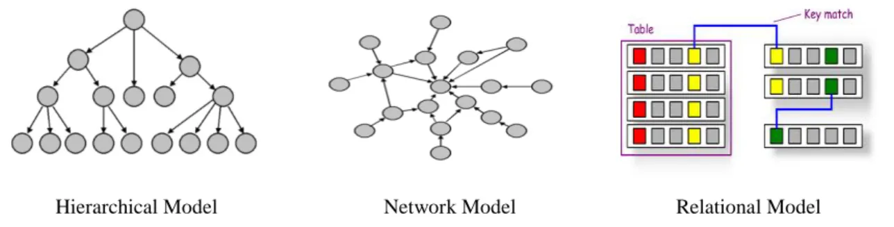
To do the data storage, there are three logical types of organizing information, hierarchical, network and relational, as can be seen in figure 3. In the first case the data is organized in a reverse tree structure, where the information goes from one to many. The network model is an extension of the previous model, where there may have relations from many to one. Finally, in the relational model data is distributed in a double entry table format, where the data query and 13
processing is carried out by column or row (Encyclopedia of Business 2nd ed., Retrieved from
http://www.referenceforbusiness.com/management/Comp-De/Data-Processing-and-Data-Management.html)
Hierarchical Model Network Model Relational Model
Figure 3: Logical types to organize information
Data processing refers to the operations done with a given set of data, to extract the necessary information, which can be presented in different formats, diagrams or table reports.
In this study, we obtained primary data with the use of GIS tools (Geographic Information System) and secondary data to comprehend the contextual environment. The data were stored in a double entry table and later processed using a spreadsheet and a mathematical software. This process will be detailed in the next Section.
7. Collection and data processing
To make the present study, several footpaths were identified, official and non-official, independent of the designation (footpath, trial, rail, pedestrian path, increase to a path, etc.) and it was made its geographical representation using a GIS tool. The beginning and the end of the footpaths were connected using the network of roads and paths. The choice of roads and paths was based on practical knowledge that the authors have from the territory, combining safety with the minimization of the distance and effort spent by the pedestrians. This way it was designed a network that integrates all the footpaths.
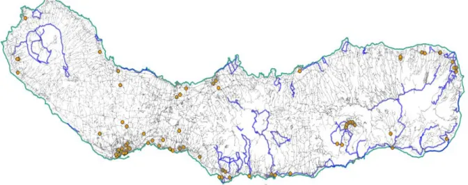
Using the documentation provided by the Regional Government and Travel Agencies that operate in the region, it was carried out the identification of the several nature, culture and social tourist sites available on the São Miguel Island. After that we pinpointed them on the map and drew the network that unites them. The same task was fulfilled for the support infrastructures, namely feeding and accommodation places. The figure 4 gives an example of a network, namely the accommodation points and the existing trails on the island.
Figure 4: Footpaths and accommodation sites on São Miguel Island
Our composition
For the networks identified above, we built tables with the identification of its nodes and lengths between edges, as well as adjacency and the distance matrix.
Before starting his walk, a pedestrian tourist that wants to enjoy a particular footpath must calculate the time he needs to do it. To optimize his tour, reduce the time spent on it or to enable the visit to further footpaths or sites, the tourist can complement his walk with other means of transportation. Thus, it was also identified the existing public transportation network on the island and their closest stop points to every footpath. Then, we developed a set of simulations to evaluate the possibility of a walking tourist enjoying the footpaths. To build these simulations, we define the same restrictions. The tourist has a fixed site of accommodation and can walk for a period of the daylight as well as can use the available public transports (bus, taxi, rent car), available either on weekdays or on weekends.
Each of the previously identified networks (footpaths, natural, cultural and social attractions, accommodations, feeding and public transport support facilities) can be represented by a matrix that contributes to the global tourism matrix of the São Miguel Island. We intended to build our model based on a linear combination of matrices that support different levels of the global network structure. Each level generates a graph, from where it will be extracted the correspondent matrix.
8. Our formulation
To achieve the mathematical formulation that explains tourist mobility, it is necessary to identify the factors that contribute that movement and their relative weight. The network
generated by each variable will be only one dimension of the matrix that will represent the entire model (Dredge, 2006). These partial networks refer to the territory, roads and paths network, logistical support points, public transport and tourist attraction. The connection between the different networks are accomplished by the geographical overlapping of its vertices.
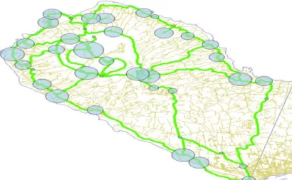
In order to simplify the data processing and to meet the proximity factor and the sense of opportunity, a simplification of the tourism network was performed by the clustering of points with distances closer than 250 meters from each other. This work permit to identify main vertices, squares, that include several vertices from the partial networks, having a greater power to attract tourists, see figure 5.
Figure 5: Clustering of the vertices
Each vertex 𝑉𝑉𝑛𝑛, from the global tourism network, will have a value of attractiveness given by the sum of the values of the various vertices of partial networks that exist physically in that place, more or less 250 meters. That value of attractiveness is weighted by the probability value assigned to the preferences of the tourists. The tourist preference is given by the level of utility that tourist perceives that can achieve with the use of the vertex. We can express the value of each vertex (1) as follows:
𝑓𝑓̂(𝑉𝑉𝑛𝑛) = 𝜌𝜌1𝑃𝑃𝑇𝑇𝑛𝑛2+ 𝜌𝜌2𝑃𝑃𝑁𝑁𝑛𝑛+ 𝜌𝜌3𝑃𝑃𝐶𝐶𝑛𝑛+ 𝜌𝜌4𝑃𝑃𝑆𝑆𝑛𝑛+ 𝜌𝜌5𝑃𝑃𝑅𝑅𝑛𝑛 + ⋯ + 𝜌𝜌𝑚𝑚𝑃𝑃𝑋𝑋𝑛𝑛 (1)
Where:
𝑓𝑓(𝑉𝑉𝑛𝑛) – Is the maximum utility that the tourist can have with the use of the 𝑉𝑉𝑛𝑛 vertex;
N - Natural attraction points;
T - Points of entrance in the pedestrian paths. Because it is considered that the pedestrian paths have a higher attractiveness value, compering to the other factors, it takes a value with quadratic expression ( 𝑃𝑃𝑇𝑇𝑛𝑛2 ) in the function (1);
C - Cultural attraction points; S - Social attraction points;
R – Feeding (restaurants) attraction places;
P – Is the weight of each component or set of components in the vertex 𝑃𝑃𝑋𝑋𝑛𝑛. It’s the weight of X category points that exist in the vertex n. If there are more than one is its weighted sum, if none exists, is assumed that the value is zero;
𝜌𝜌𝑚𝑚 – is the utility value assigned to the consumption of each vector, that is, the preference probability assigned by the tourist to each point or set of points;
n - Index assigned to each vertex.
Because the accessibility level to each vertex must be taken into account, as Lew and
McKercher (2006, pp. 405-413) theorize, we should incorporate this value into the expression
(1), becoming as expression (2).
𝑓𝑓(𝑉𝑉𝑛𝑛) = 𝑓𝑓̂(𝑉𝑉𝑛𝑛)+ � 𝜌𝜌𝑚𝑚𝑗𝑗𝑃𝑃𝐴𝐴𝑗𝑗
𝑘𝑘 𝑗𝑗=1
(2)
𝑃𝑃𝐴𝐴𝑗𝑗 – is the weight given to accessibility.
This becomes from absorption by the n vertex of the value of the edge between the individual and the location of the vertex in question. It represents the effort that the tourist has to accomplish to reach the vertex n.
Considering that the goal of the tourist is to maximize the utility level obtained in the throughout the travel, we have to add all the vertices where the tourist will pass.
The objective function is:
max � 𝑓𝑓𝑗𝑗 (𝑉𝑉𝑛𝑛)
𝑘𝑘
𝑗𝑗=1 (3)
Each vertex of a subnet (N, T, C, ...) is subdivided into several lower-level categories, each one of them have different specific weights and distinct utility values to each tourist. Considering as an example, the weight of the natural attraction points network can express as follows in expression (4).
𝑃𝑃𝑁𝑁𝑛𝑛 = ∝1 𝑃𝑃𝑁𝑁𝑁𝑁𝑛𝑛 +∝2 𝑃𝑃𝑁𝑁𝑁𝑁𝑛𝑛 +∝3 𝑃𝑃𝑁𝑁𝑁𝑁𝑁𝑁𝑛𝑛 + ⋯ +∝𝜏𝜏 𝑃𝑃𝑁𝑁𝑁𝑁𝑁𝑁𝑛𝑛 (4)
Where:
𝑃𝑃𝑁𝑁𝑁𝑁𝑛𝑛 – Is the n viewpoint weight;
𝑃𝑃𝑁𝑁𝑁𝑁𝑛𝑛 - Is the n lagoon weight;
𝑃𝑃𝑁𝑁𝑁𝑁𝑁𝑁𝑛𝑛 - Is the n natural park weight;
𝑃𝑃𝑁𝑁𝑁𝑁𝑁𝑁𝑛𝑛 - Is the n beach weight
∝𝜏𝜏 - Is the utility value assigned to each consumption vector, 𝜏𝜏 = 1,2, … , 7
Within each subcategory of attractions, the weight is defined as the product of factors such as reputation, proximity to other points of interest or the cost of its use.
Because individuals are different, based on initial preferences, possible options can be restricted, therefore achieving a system simplification. As an example, if the tourist had hired accommodation for the whole stay in one place, all other accommodation places assume a null value.
Another situation of initial simplification is when the tourist assumes that doesn’t intend to visit points of a specific characteristic, in this case, all the points with this feature will take null value. In mathematical terms, if the tourist state that doesn’t want to visit churches, every churches points assume a utility value equal to zero and can be impose the following condition.
� ∝𝑛𝑛𝑗𝑗 𝑃𝑃𝐶𝐶𝑔𝑔𝑗𝑗
𝑛𝑛 𝑗𝑗=1
= 0 (5)
By its importance, as a scarce resource, the analysis of the viability of each travel must be analyzed in terms of temporal availability. Thus, each vertex and edge have an associated time
value, that represents the number of time units (t) required for tourists to enjoy the total points associated with that vertex or to go through an edge. At the end, the sum of the time units spends on the edges and on the vertices can’t exceed the total time assigned by the tourist to the travel.
� 𝑡𝑡𝑗𝑗 𝑘𝑘 𝑗𝑗=1
= 𝑡𝑡𝑚𝑚𝑁𝑁𝑚𝑚 (6)
Where:
𝐶𝐶𝑔𝑔 - Cultural attraction points from the church type;
𝑡𝑡𝑗𝑗 – Time unit, having been chosen as standard unit the minute; 𝑡𝑡𝑚𝑚𝑁𝑁𝑚𝑚 – Maximum time units available to perform the travel.
The mathematical modelling will provide a better understanding of the patterns of tourists’ movement, identifying motivations and limitations. This knowledge, as part of a strategic sector for regional development, allows economic performers and policy makers to make better decisions, leading to an optimization of existing resources according to the tourists’ real expectations. On the other hand, the mathematical model will allow to build tools that will help tourists, individually, to optimize their experience.
9. Conclusions
The small remote island territories are susceptible to natural disasters and suffer from a particular disadvantage in their economic development capacity (Briguglio, 1995). The same properties that put island populations in disadvantage make the islands a useful study of support for scientists. The islands are preferred study units, becoming the foundation for significant advances in many scientific areas, because it is a system that can be controlled/constrained in many ways (Deschenes & Chertow, 2004).
It is recognized that tourism triggers a sustained positive effect in economic growth of small countries or regions (Schubert, Brida, & Risso, 2011). The São Miguel Island is located in a remote region of Europe, where tourism is recognized as a strategic aspect of its development, so, it makes sense to study the mobility of tourists within the region.
The creation of a mathematical model that enhances the development of the region through customized tourism, assumes a great importance in the regional economy and allows to build tools that will help tourists, individually, to optimize their experience.
The model that will be developed for the São Miguel Island, because it is based on universal scientific basis, will be applicable to other similar regions, whether island or not, by its adjustment to any region with similar characteristics or an indirect application to regions with different characteristics, after an adjustment process. The authors hope, therefore, to contribute to the advance of scientific knowledge in the area, providing a useful tool for real-world operators, towards regional development.
Acknowledgments
Gratefully acknowledge financial support from FCT- Fundação para a Ciência e Tecnologia (Portugal), national funding through research grant (UID/SOC/04521/2013) and to the ADVANCE-Advanced Research Centre in Management.
Bibliography
Baggio, R. (2008). Symptoms of complexity in a tourism system. Tourism Analysis, 13 (1), 1-20.
Baldacchino, G. (2008). Trains of Thought: Railways as Island Anthitheses. Shima: The International Journal of Research into Island Cultures, 2 (1), pp.29-40.
Bansal, H., & Eiselt, H. (2004). Exploratory researchof tourist motivations and planning. Tourism Management, 25 (3), 387–396.
Beerli, A., & Martı́n, J. D. (2004). Tourists’ characteristics and the perceived image of tourist destinations: a quantitative analysis—a case study of Lanzarote, Spain. Tourism Management, 25 (5), 623–636.
Braga, T. (2006). Pedestrianismo e Percursos Pedestres: manual de formação (1 ed.). Pico da Pedra, Açores, Portugal: Amigos dos Açores.
Briguglio, L. (1995). Small island developing states and their economic vulnerabilities. World Development, 23 (9), 1615-1632.
Chiang, A. C., & Wainwright, K. (2005). Matemática para economistas (4ª ed.). (A. S. Marques, Trans.) Rio de Janeiro: Elsevier Editora Ltda.
Correia, A., Valle, P. O., & Moço, C. (2005). Modelling motivations and perceptions of Portuguese tourists. Retrieved February 26, 2015, from http://w3.ualg.pt/~acorreia/ document/publicacoes/modeling%20motivations%20and%20perceptions..pdf
Costa, L. d., & Baggio, R. (2009). The web of connections between tourism companies: Structure and dynamics. Physica A: Statistical Mechanics and its Applications, 388 (19), 4286-4296.
Crouch, G. I., & Ritchie, J. R. (1999). Tourism Competitiveness and Societal Prosperity. Journal of Business Research, 44 (3), 137–152.
Debbage, K. G. (1991). Spatial behavior in a bahamian resort. Annals of Tourism Research, 18 (2), 251-268.
Deng, J., King, B., & Bauer, T. (2002). Evaluating natural attractions for tourism. Annals of Tourism Research, 29 (2), 422-438.
Deschenes, P. J., & Chertow, M. (2004). An island approach to industrial ecology: towards sustainability in the island context. Journal of Environmental Planning and Management, 47 (2), 201-217.
Dredge, D. (2006). Policy networks and the local organisation of tourism. Tourism Management, 27 (2), 269-280.
Filieri, R., & McLeay, F. (2014). E-WOM and accommodation an analysis of the factors that influence travelers’ adoption of information from online reviews. Journal of Travel Research, 53 (1), 44-57.
Frias, A., & Cabral, J. (2013). Facility Localization: Strategic Decision on Insular Territory. Asia Online Journals: Asian Journal of Business and Management, 1, nº.5 (1), 217-225. Frias, A., Cabral, J., & Costa, Á. (2014). Otimização do uso dos trilhos pedestres em São Miguel e sua modelação matemática. In Proceedings of the 21º Workshop da APDR - Estratégias, Infra-estruturas e Redes Empreendedoras para o Desenvolvimento Regional (pp. 54-68). Angra do Heroísmo: Associação Portuguesa para o Desenvolvimento Regional.
Howley, P., Doherty, E., Buckley, C., Hynes, S., Rensburg, T. v., & Green, S. (2012). Exploring preferences towards the provision of farmland walking trails: A supply and demand perspective. 29 (1), 111-118.
Kaewsuwan, S. (2002). Importance of Models in Economics. Retrieved November 3, 2014, from http://www.gaoshan.de/university/tp/Importance_of_Models_in_Economics.pdf
Khadaroo, J., & Seetanah, B. (2007). Transport infrastructure and tourism development. Annals of Tourism Research, 34 (4), 1021-1032.
Kitazawa, K., & Batty, M. (2004). Pedestrian Behaviour Modelling: An application to retail movements using a genetic algorithm. In J. Van Leeuwen, & H. Timmermans (Eds.), Developments in Design & Decision Support Systems in Architecture and Urban Planning (pp. 111-126). Eindhoven: Eindhoven University of Technology.
Lau, G., & McKercher, B. (2007). Understanding tourist movement patterns in a destination: A GIS approach. Tourism and Hospitality Research, 7 (1), 39-49.
Lew, A., & McKercher, B. (2006). Modeling Tourist Movements: A Local Destination Analysis. Annals of Tourism Research, 33 (3), 403-423.
Lue, C.-C., Crompton, J. L., & Stewart, W. P. (1996). Evidence of Cumulative Attraction in Multidestination Recreational Trip Decisions. Journal of Travel Research, 34, 41-49.
Masiero, L., & Zoltan, J. (2013). Tourists intra-destination visits and transport mode: a bivariate probit model. Annals of Tourism Research, 43, 529-546.
Mckercher, B., & Lau, G. (2008). Movement Patterns of Tourists within a Destination. Tourism Geographies: An International Journal of Tourism Space, Place and Environment, 10 (3), 355-374.
Midmore, P. (2000). The Economic Value of Walking in Rural Wales. University of Wales. Wrexham, Wales: Ramblers’ Association in Wales and Welsh Institute of Rural Studies. Miguéns, J., & Mendes, J. (2008). Travel and tourism: Into a complex network. Physica A: Statistical Mechanics and its Applications, 387 (12), 2963-2971.
Mooney, D. D., & Swift, R. J. (1999). A course in mathematical Modeling. United States of America: The Mathematical Association of America.
Murphy, P., Pritchard, M. P., & Smith, B. (2000). The destination product and its impact on traveller perceptions. Tourism Management, 21 (1), 43-52.
OECD. (2014, março 07). OECD Tourism Trends and Policies 2014. (O. publishing, Ed.) Quivy, R., & Campenhoudt, L. V. (1998). Manual de investigação em ciências sociais. Porto. Retrieved 11 4, 2014, from http://www.fep.up.pt/docentes/joao/material/manualinvestig.pdf RAA. (2009). Estudo sobre os Turistas que visitam os Açores. 2005 – 2006. Angra do Heroísmo: Serviço Regional de Estatística dos Açores (SREA).
Samuelson, P. A., & Nordhaus, W. D. (2005). Economia (18 ed.). (E. fontaínha, & J. P. Gomes, Trans.) Aravaca: McGraw-Hill Interamericana de España, S.A.U.
Schubert, S. F., Brida, J. G., & Risso, W. A. (2011). The impacts of international tourism demand on economic growth of small economies dependent on tourism. Tourism Management, 32, 377-385.
Shih, H.-Y. (2006). Network characteristics of drive tourism destinations: An application of network analysis in tourism. Tourism Management, 27 (5), 1029-1039.
Turismo de Portugal IP. (2011). Plano Estratégico Nacional do Turismo: proposta para revisão no horizonte 2015 - versão 2.0. Lisboa: Turismo de Portugal IP.
Zoltan, J., & McKercher, B. (2015). Analysing intra-destination movements and activity participation of tourists through destination card consumption. Tourism Geographies: An International Journal of Tourism Space, Place and Environment, 17 (1), 19-35.