.ufc.br
ISSN: 1984-2201
Copyright © 2002, Universidade Federal do Ceará ARTICLES
ENVIRONMENTAL ANALYSIS
THROUGH NETWORK GRAPHICS
(*) CORRESPONDING AUTHOR
Address: UNESP - Avenida 24A n. 1515, CEP: 13506900, Rio Claro (SP), Brasil. Tel: (+55 19) 35269331. E-mail: FelipeASZ@hotmail.com
Article history:
Received 10
April, 2018
Accepted 20 June, 2018
Publisher 15 October
, 2018
(a) PhD in Geography. Paulista State University (UNESP), Rio Claro (SP), Brazil. ORCID ID: https://orcid.org/0000-0002-3896-6148. CUR-RICULUM LATTES: http://lattes.cnpq.br/8626099819877222
(b) PhD in Geosciences and Environment. Professor Paulista State University (UNESP), Rio Claro (SP), Brazil. ORCID ID:
https://orcid.org/0000-0002-4732-1421. CURRICULUM LATTES: http://lattes.cnpq.br/2689821323942199
(c) PhD in Geosciences and Environment. Professor Federal University Mato Grosso (UFMT), Cuiabá (MT), Brazil. ORCID ID: https://orcid.
org/0000-0002-1565-2250. CURRICULUM LATTES: http://lattes.cnpq.br/6098281958731476
ZANATTA, Felipe Augusto Scudeller; a * LUPINACCI, Cenira Maria; b
BOIN, Marcos Norberto; c
ABSTRACT
This article aims to discuss the erosive problem of the high basin of Areia Dourada stream, Marabá Paulista (SP), through a joint evaluation of the erosive forms with the physical and anthropic variables. From the methodological principles, we analyzed the information of lithology, soils, relief forms and relief energy, identifying the restriction to the use, conceived from the potential for erosion of the evaluated variables. This restriction was analyzed in conjunction with land use, making it possible to identify the compatibility and incompatibility relationship of the current use with the physical characteristics of the grounds and the erosive forms. This information was worked together from network graphics. As a result, we obtained a synthesis of the complexity between the combinations of the physical and anthropic variables, which allowed to indicate the forcing elements of the system, catalysts of the erosive processes, the mechanisms by which the processes evolve and the grounds subject to erosion, in case the current conditioners remain. Keywords: Physical characteristics; Land use, Forcing the system; Erosive processes.
RESUMO / RESUME
ANÁLISE AMBIENTAL ATRAVÉS DE GRÁFICOS EM REDE
Este artigo aborda a problemática erosiva da alta bacia do ribeirão Areia Dourada, Marabá Paulista (SP), mediante avaliação conjunta das formas erosivas com as variáveis físicas e antrópicas. Para tanto, a par-tir de princípios metodológicos foram analisadas as informações de litologia, solos, formas de relevo e energia do relevo, identificando a restrição ao uso, concebida a partir do potencial à erosão das variáveis avaliadas. Essa restrição foi analisada em conjunto com o uso da terra, possibilitando identificar a relação de compatibilidade e incompatibilidade do uso atual com as características físicas dos terrenos e as formas erosivas. As informações mencionadas foram trabalhadas conjuntamente a partir de gráficos em rede. Como resultado, obteve-se uma síntese da complexidade entre as combinações das variáveis físicas e antrópicas, que permitiram indicar os elementos de forçamento do sistema, catalisadores dos processos erosivos, os mecanismos pelos quais os processos evoluem e os terrenos sujeitos à erosão, caso os condicionantes atuais se mantenham.
Palavras chaves: Características físicas; uso da terra, forçamento do sistema; processos erosivos. ANALYSE ENVIRONNEMENTALE AVEC DES GRAPHIQUES EN RÉSEAU
Cet article traite de la problématique érosif du haut bassin de la rivière Areia Dourada, à Marabá Paulista (SP), à travers d’une évaluation conjointe des formes érosives avec les variables physiques et anthropi -ques. Pour ce faire, à partir des principes méthodologiques, les informations sur la lithologie, les sols, les formes de relief et l’énergie du relief ont été analysées, en identifiant la restriction d’usage, conçue à partir du potentiel d’érosion des variables évaluées. Cette restriction a été analysée en liaison avec l’utilisation du sol, permettant d’identifier le rapport de compatibilité et d’incompatibilité de l’usage actuel avec les caractéristiques physiques des sols et les formes érosives. Les informations mentionnées ont été combinées à partir de graphiques en réseau. En conséquence, une synthèse de la complexité entre les combinaisons de variables physiques et anthropiques a été obtenue, ce qui a permis d’indiquer les éléments de forçage du système, des catalyseurs des processus érosifs, les mécanismes par lesquels les processus et les terrains soumis à l’érosion évoluent, dans le cas où les conditions actuelles se maintiennent.
www
.mercator
INTRODUCTION
According to a 2014 report by the United Nations Environment Program (UNEP), around 25%
of the planet’s land has suffered a decline in quality and productivity due to too much deforestation
and inadequate land use, mainly by conventional or intensive agricultural management that
pro-motes erosion (FAO, 2015). This problem is not restricted to the soil, it multiplies, affecting water
quality, reducing biodiversity and limiting food production.
In a study carried out by Sampaio (2005) to propose an agrarian reform project, the author stated that 120 million ha of land in Brazil were degraded; data from 2012 indicated that, in a period of seven years, these areas had increased to 140 million ha (MMA, 2012).
Silva and Mateo-Rodriguez (2014) associate the problem of erosion with the complexity
of the interactions and exchanges of flows of materials and energy of natural ecosystems, which
are generally disregarded during the processes of use and occupation of natural resources. There is still a need to distinguish the social actors and the political and agrarian structures that neglect the potential of distinct ecosystems and favor inappropriate use, which, in addition to generating the abovementioned environmental problems, hampers the implementation of other more sustainable forms of land use.
On this subject, Porto-Gonçalves (2012), in a study in the Brazilian Amazon region, verified that land use, influenced by the European culture that still dominates the Brazilian elites, “does not
arise from the actual reality of the ecosystem which it manufactured itself, with those nutrients,
that biomass “(PORTO-GONÇALVES, 2012 p.45), but instead causes forest clearance for the im
-plantation of monocultures and extensive livestock farming. According to the author, in addition to reducing productivity, this relationship with natural resources in the region has led to the loss of millions of tons of soil every year and invaluable biodiversity assets.
As in the Amazon, in the other regions and ecosystems of the national territory, such as the
Cerrado (PORTO-GONÇALVES, 2004) and the Atlantic Forest, W of the State of São Paulo (THO
-MAZ Jr., 2009), the predatory use of natural resources expands through the agricultural frontier
under the domain of agribusiness, which appropriates the structure of the latifundia, the country’s
environmental and agricultural policy and establishes the monoculture of commodities in rural are-as. This process has reduced the area of biomes, threatens legally protected areas, and suppresses socio-territorial movements, reducing the action of peasants, extractivists and indigenous, riverine and quilombola communities that establish more sustainable ways of using natural resources. A model that, due to low crop rotation, monoculture, the extension of production areas and the need for the excessive use of agricultural inputs, causes serious consequences to the environment,
incre-ases inequality and violence in the field, affects health and endangers the population’s food safety (PORTO-GONÇALVES, 2004; PORTO-GONÇALVES, ALENTEJANO, 2010).
In the political sphere, the influence of agribusiness has brought about recent changes in the
Forest Code (Law 12,651 / 2012), significantly reducing legally protected areas on private pro
-perties and granting amnesties to those who devastate Brazilian biomes. Allied to this fact, both
the allocation of the government’s billion-dollar incentives to agribusiness and the insertion the
Proposed Amendment to the Constitution (PEC) 215 on the legislative agenda, which transfers the demarcation of indigenous lands, Conservation Units and Quilombola territories from the Union
(executive power) to the National Congress (legislative power), have a decisive influence in favor
of agribusiness since the sector has 263 out of the 513 existing congressmen (FPA, 2015).
These situations violate the 1988 Federal Constitution, regarding the use of natural resources
and the agrarian reform issue (Chap. III), the rights of traditional communities (Chap. VIII; Title X, Art.68) and aspects of the environment (Cap.VI), projecting an increasingly worrying scenario
.ufc.br
Environmental Analysis Through Network Graphics
In the Pontal do Paranapanema region, W in the state of São Paulo, covering 26 municipalities
(4% of the state), there are 3,621 erosive forms as ravines and gullies, 12% of the whole state (IPT, 2012). The occupation of the region dates from the end of the nineteenth century and the beginning of the twentieth century through land grabbing and the extermination of indigenous peoples for
the expansion of coffee cultivation (FERRARI LEITE, 1998; MONBEIG, 1984). Nowadays, it is
dominated by extensive livestock farming; much of the land has been degraded and has become an attraction for sugar-ethanol companies, which, supported by strong incentives from the National Development Bank (BNDES), have establish the monoculture of sugarcane in the region. Accor-ding to Thomaz Jr (2009), this advance, under the protection of the State that acts as guarantor for landowners / landgrabbers and of the sugarcane capital, occurs in areas that should be destined to agrarian reform, weakening the socio-territorial movements and, consequently, making the deve-lopment of more sustainable forms of land use in the region impossible.
When studying a 46 km² fragment of the Pontal do Paranapanema that makes up the upper basin
of the Areia Dourada stream, Marabá Paulista (SP), Zanatta et. al. (2015) used the history of land use related to erosive processes to verify that the increase of areas of sugarcane cultivation, even when accompanied by agricultural terraces and the enclosure of the margins of ravines and gullies, dynamizes the erosive problem of the Basin. Thus, it was observed that there is no adaptation to or respect for the limits of the local ecosystem, nor is there any concern with environmental preserva-tion or the history of degradapreserva-tion of the region, reproducing the predatory use of natural resources. In order to understand the conditioners that result in the 385 erosive furrows, 138 ravines and seven gullies, in addition to the 137 plots of land that present marks of laminar erosion and the
seven fluvial channels with undermined banks found in the 46 km² that comprise the upper basin
of the Areia river, this paper aims to present an approach to the erosive problem through the joint evaluation of the erosive forms with the physical and anthropic variables. In order to do so, an instrument in the form of a network graphic is presented, based on the basic notions put forward by Mateo Rodriguez (et al., 2004) and Leal (1995).
Finally, the results were analyzed by means of the determinations of the 1988 Federal
Consti-tution, regarding the environment (Cap. VI) and the social function of private property (Chap. III),
in order to point out possible solutions to the erosive problem of the Basin.
THE UPPER BASIN OF THE AREIA
DOURADA STREAM
The upper basin of the Areia Dourada stream is composed of sediments of the Bauru Group, stratigraphically subdivided into the sandstones of the Santo Anastácio Formation, superimposed on
the younger Adamantina Formation. As both have the characteristics of fluvial environments, they have sandstones with fine to very fine granulometry and a selection from regular to bad, however,
the latter is distinguished by the level of lacustrine base, cementation by calcium carbonate - which denotes greater resistance - and an intercalation of silt-clay and sandy banks.
Geological faults dating from the Quaternary, which run SSE-NNW with a SSW-NNE inflection (STEIN, 1999), defined the path of the Areia Dourada stream and consequently, the readjustment of the entire drainage network, resulting in the asymmetric form of the Basin, which presents W
portion with higher elevations and extensive slopes and E with broad tops and short slopes (ZA-NATTA et al, 2015).
Located on the top, middle and upper slope areas of the basin, the Adamantina Formation, due to its more resistant characteristics, determines the presence of secondary tops (ZANATTA, 2014)
www
.mercator
convex slopes of this sector. In addition, this soil class occurs predominantly in the top areas. On the medium slope, the interleaving of silt-clay and sandy banks results in abrupt topographical
breaks and promotes upwelling groundwater, soils subject to hydromorphism and diffuse sources, mainly in the NW section and medium and high slopes to the Midwest. In the other slopes of the
Basin, the formation of abruptly translocated Red Argosols predominates. On the other hand, the Santo Anastácio Formation is located on the lower slopes and valley bottoms, where erosion has removed sediments from the Adamantina Formation.
The sectors with topographic ruptures, on the upper and middle slope, where the Adamantina Formation is located, occurs through the intercalation of silt-clay and sandy banks, characteristic of this Formation; whereas on the low slope, they arise as a result of the contact between the Santo
Anastácio and Adamantina Formations, which are composed of materials with significantly different resistance. In both cases, topographic ruptures determine ≥ 20% slopes and consequently, the energy
of the relief is strong to very strong. In the other slopes of the Basin, gentler slopes predominate
with medium to moderate energy. On the flat tops, with slopes below 5%, the relief energy is weak
to very weak (BOIN et al., 2014).
All the classes of soils in the study area have a high percentage of sand in their composition,
approximately 80%, mainly fine sand, resulting in a low aggregation of the granulometric fractions
(CARVALHO, 1997), easily broken down and carried by rainfall, mainly in the spring and sum
-mer, where the rains are concentrated in heavy bursts or last for days (BOIN, 2000). In these lands, the presence of the native vegetation of the Atlantic Forest Biome has permitted a large volume
of organic carbon in the most superficial horizons, which significantly improved the aggregation,
fertility and protection of the soils.
Monbeig (1989) reports that the colonel-farmers who sought new lands to expand coffee cul
-tivation in the late nineteenth and early twentieth centuries were excited by the exuberance of the
forest and the presence of species that testified to the fertility of soils in the W of Sao Paulo state, thus propitious to be dominated by coffee cultivation. Few suspected the poverty of the soils below
the vegetation, which over the years had provided favorable conditions for the development of
large species. Without the protection and cycling of nutrients carried out by the native vegetation, the superficial layers, rich in organic matter, are slowly removed by the rains, leaving the sandy
soil behind.
In previous studies of the occupation of the area (ZANATTA, 2014, BOIN et al., 2014 and
ZANATTA et al., 2015), it has been verified that from that point until the present, all forms of land
use have established predatory actions towards natural resources and, consequently, exposed the
soils to the erosive action of rainfall. In the 46 km² that make up this study area, the presence of only 0.99% of forest vegetation, dispersed and in small fragments, was verified. This form of land
use has led to the re-adaptation of the drainage network of the basin, which had 29 river channels in 1962; by 2013 this had increased to 71 (ZANATTA, 2014). This adaptation of the Basin to es-tablished uses occurs mainly through linear erosive processes, with consequences at the bottom of the valley, such as undermining and the silting of water bodies.
MATERIALS AND METHODS
First, the cartographic base was developed, using the IBGE topographic charts (1976), on a scale of 1: 50,000, represented cartographically in the Marabá Paulista (SF-22-YB-II-1) and Ri-beirão das Anhumas (SF-22-YBI-2). Secondary sources were also researched for maps and studies previously conducted in the area. At this stage, the soil charts of the Santo Anastácio river basin,
on a scale of 1: 250,000 (CARVALHO, 1997), and the morphometric charts of the upper Areia
Dourada river basin were obtained on a scale of 1: 50,000 (BOIN et al, 2014) and the geological chart of the Santo Anastácio river basin, on a scale of 1: 250,000 (STEIN, 1999). These charts were
.ufc.br
Environmental Analysis Through Network Graphics
Later, the other cartographic documents were elaborated. The geomorphological charts, based on the Tricart (1965) and land use principles of the year 2013, according to IBGE (2006) standards, were based on the interpretation of aerial photographs of the Companhia Paulista de Planejamento Metropolitano (EMPLASA) on a Ground Sample Distance (GSD) scale of 45 centimeters; both
mappings were carried out on the 1: 50,000 scale, aided by fieldwork in the years 2011, 2012 and
2013.
After the aforementioned mappings, based on Leal’s proposal (1995), there was a crossing
of information on relief forms (top, concave, convex and rectilinear slopes and valley bottoms), lithologies (Adamantina and Santo Anastácio Formations), soils (Altered Red Latosol, Dystrophic
Red Argosol, Eutrophic Haploid Gleisoil, Eutrophic Littoral Neosol and hydromorphic soil) and
relief morphometry (weak, medium to medium strong and strong to very strong).
The physical variables were grouped according to the theoretical potential for the formation and development of erosive processes of each thematic class, evaluated in an isolated way and
combined with the others, from which the use restriction was defined: low, medium and high. For
example, top areas with low relief energy and with Red Alkalis Latosol were considered a low res-triction. Tops, convex or rectilinear slopes that had medium to moderately weak energy in an area with Red Alkool or Red Dystrophic Argosol were considered of medium restriction. On the other hand, the terrain found on concave slopes and / or relief energy from strong to very strong and / or with Neosol Litotic or soil subordinated to hydromorphism, independent of the other variables, were considered of high restriction, the protection and preservation of native vegetation being essential. This mapping is in Zanatta, Lupinacci and Boin (2016).
The physical variables grouped by restriction were crossed with the land use information, generating compatibility information (when the use complies with the restriction) and incompati-bility (when the use exceeds the restriction limit of the environment). To these, in a last step, data of erosive features of the geomorphological charts (marks that indicate laminar erosion, furrows,
ravines and gullies) were also included, resulting in five classes that indicate the environmental
state, as shown below:
• Optimized: areas with preserved and protected native vegetation, ensuring the stability of
geomorphological processes;
• Compensated: areas where the uses are compatible with the restriction, so as not to affect
the geomorphological processes;
• Altered: areas where use is not compatible with the existing restriction. There is no evidence
of destabilization of the geomorphological processes, however, there is a strong tendency;
• Intensely altered: besides the incompatibility, there is laminar erosion and / or furrow marks.
There is still the possibility, through changes in land use and a combination of conservationist techniques, that these lands may return to a state close to natural;
• Depleted: there are ravines or gullies without any possibility of the environment returning
to its original state, since a new structure is in advanced development.
The environmental states mentioned above are based on principles presented by
Mateo--Rodrigues et al. (2004) and Leal (1995), which propose a land classification according to the transformations provoked by land use, indicating the degree of consequent modification, that is,
the distancing from the original characteristics of these areas.
All the aforementioned information derived from mapping were transformed into network graphs in order to synthesize the complexity of the relationships between the physical characteristics of the Basin, the land use and the consequent geomorphological processes.
com-www
.mercator
binations of the physical variables that present a certain shape of the relief (top, slope), the litho-logical composition, the pedolitho-logical and morphometric characteristics (relief energy). From the interaction of these factors, the land use restrictions were established, which are represented in the graphical schemes by the color of the lines (green for low restriction, orange for medium restriction and brown for high restriction) that establish the relationship between the physical variables. At the bottom of the graphical representation, the relationship between the use restriction, land use and
conservation techniques was established. This relationship was classified as compatible (lines in
green) or incompatible (lines in red), and the thickness of the lines indicates the number of situations with these characteristics. In cases where the environmental state is intensely altered and depleted, a circle representing the erosive form (Figure 1) was added in each thematic class.
Figure 1 - Network graph model applied to the environmental analysis of the erosive problem.
In the network graphics, the valley bottoms were not considered, since there are no direct uses, but rather the consequences of the uses carried out on the slopes and tops. Therefore, a separate analysis will be done of the valley bottoms evaluating these situations through the mapping of use restrictions, geomorphology and land use.
The analysis of the interactions between the elements that compose the landscape used principles of systems theory, with the evaluation of the medium being done through inputs and
ou-tputs of flows of matter, energy and information, which are processed in the landscape’s structure,
determining the dynamics and the functioning of the system. If the variables are in equilibrium, the processed inputs generate minimal transformations in the landscape, being balanced by the
outputs evacuated by the system. Thus, the system remains in a stable state. When the variables
are not balanced, the inputs alter the structure and functioning of the landscape, generating more outputs. This situation persists until the variables that determine the imbalance of the system are adjusted and, for this, a new structure and a new functioning is created, altering all the other ele-ments (MATEO-RODRIGUEZ et al., 2004).
RESULTS
This analysis starts from the environmental status chart (Figure 2), in which the spatialization of
.ufc.br
Environmental Analysis Through Network Graphics
of the network graphs by environmental state, in order to demonstrate the combination of physical and anthropic elements that result in the maintenance of the original morphological characteristics
(optimized and compensated states) and the different levels of alteration of the environment studied
(altered states, intensely altered and exhausted).
Figure 2 - Chart of the environmental state of the Areia Dourada upper river basin, Marabá Paulista (SP)
Figure 2 shows that the optimized state prevails in land on the valley bottom covered by wetland
vegetation, with few situations on the slopes, while the compensated state, 2.04%, mainly affects
lands with low restrictions, on the tops and convex or rectilinear slopes. Therefore, in the study area there is a predominance of combinations of physical and anthropic themed classes that tend to morphological alterations. Most of the study area is in an altered state, which occupies 68.78% of the basin. In this situation, the surface uses and cover are not in accordance with the use restriction,
as well as the intensely altered land, which cover 24.02% of the area. However, unlike the former, in
the intensely altered areas, erosive forms were registered at an early stage, such as marks indicating laminar erosion and / or furrow erosion. On the other hand, the depleted state where erosion has altered the original morphology, as in ravine and gully conditions, occurred in 2.86% of the area, mainly in the concavities and in the vicinity of the valley bottoms.
THE OPTIMIZED STATE
The optimized state occurs in only 2.31% of the Basin studied, in reforestation situations and native forest vegetation, when in the valley bottom, due to the presence of characteristic wetland
vegetation. In this environmental state, the superficial cover presents a heterogeneity of species of
www
.mercator
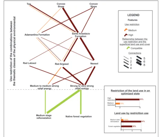
In its distribution in the thematic classes of the physical environment, the optimized state occurred in eleven distinct combinations, especially in land with high use restrictions, such as in the convex slopes on the Adamantina Formation with Litho Neosol or Red Argosol in which strong to very strong energies predominate, concave slopes or tops with strong to very strong relief energy (Figure 3).
Figure 3 - Physical and anthropogenic characteristics of the lands in an optimized environmental state.
The two combination of variables (tops, in Santo Anastácio Formation lithologies, with Red Argosol and medium to medium strong energy and convex slopes on Adamantina Formation in Argosol and medium to moderate energy), which resulted in an average use restriction, are occu-pied by reforestation in the middle stage of regeneration (Figure 3). The native forest vegetation occurs in the form of several fragments scattered along the banks of the Areia Dourada stream, predominantly in areas of high restriction.
Figure 3 shows that the optimized state is mainly found in land that is difficult to use for far
-ming purposes, evidenced by areas that, after attempted use, were destined for reforestation; when
inspected in the field these did not have any protection or enclosure.
THE COMPENSATED STATE
This environmental state occurred in six distinct combinations of thematic classes of the
phy-sical environment, five of medium restriction and one of low use restriction. They comprise the
lowest percentage of the entire area of basin, occurring at 2.04% (Figure 4).
.ufc.br
Environmental Analysis Through Network Graphics
Figure 4 - Physical and anthropogenic characteristics of the land in a compensated environmental state.
The situations of medium use restriction focus on straight and convex slopes, with
characte-ristics of dispersion of the water flow. The rectilinear slopes are dominated by Red Latosol, while
on the convex ones Argisols are recorded on more resistant lithologies of the Adamantina Forma-tion; in both situations there is medium to medium strong energy. Such conditions make the use of sugarcane and pasture possible without altering the original morphology of the land.
Other elements to be highlighted in Figure 4: sugarcane dominates the best lands in the area, those with low restrictions, occupying 84% of the total; the areas cultivated with cane and pasture in low and medium restriction land have the same conservation techniques, such as the use of
agri-cultural terraces, regardless of the differences between the size, depth and structure of the roots,
the production of organic matter and the physical characteristics of the land.
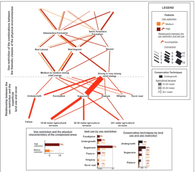
THE ALTERED STATUS
This environmental state predominates in the study area, covering 68.78% of the entire Basin. It prevails in combinations, 75% (18), which give rise to a high restriction of use and, to a lesser
extent, 25%, in combinations that result in medium restriction (Figure 5). In the first case, the high
restriction limits use to reforestation or native vegetation cover; consequently, any other use has a
significant potential for the formation and development of erosive processes. In the second case,
www
.mercator
Figure 5 - Physical and anthropogenic characteristics of the land in an altered environmental state.
The thickness of the line on the graph shows that concave slopes predominate in this envi-ronmental state, mainly covered by sugarcane, followed by pastures. Low vegetation appears on
fallow land, which is located on the banks of rivers and erosion processes. It was verified in the
field that the boundary of these fenced areas with low vegetation is established by the safe distan
-ce for machinery operation, so that no landslides occur. Thus, issues of stagnation or recovery of eroded lands are not considered, and when they border river channels, in some situations, they are inadequate for the limit of Permanent Preservation Areas (APP) determined by Law 12.651 / 2012 (ZANATTA et al., 2015).
The highways, rural roads and eucalyptus are not accompanied by any conservation
techni-ques, especially the highways and roads that redirect the surface runoff. Such conditions contribute
to the development of erosive processes in downstream soils.
Extensive cattle rearing, and the monoculture of sugarcane contribute significantly to the
altered state of much of the Basin, especially sugarcane on land with strong to very strong energy
(Figure 5). This superficial cover extends over large areas, ranging from tops, to concave, convex and rectilinear slopes, and to four of the five classes of soils - except the Gleisoil’s of the valley
bottoms - present in the studied area (Figure 5).
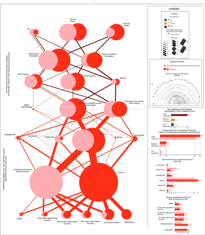
THE INTENSELY ALTERED STATE
.ufc.br
Environmental Analysis Through Network Graphics
and recovery with simple soil treatment, accompanied by an adequate use of its physical charac-teristics. It occurs in 24.02% of all areas, being the second largest in territorial terms, found in all use restrictions, but predominantly in high restriction areas, with 84% of the furrows and 86% of the features that indicate laminar erosion (Figure 6).
Figure 6 - Physical and anthropogenic characteristics of heavily altered soils.
The presence of laminar erosion in low-restriction land, such as the tops, with Latosols and
low energy, is also verified, due to the overgrazing of the land. The six combinations that occur in
medium restriction areas have grooves and marks that indicate laminar erosion, occurring both in top areas with Latosols and in the convex slopes with Argosol.
As for the combinations, the lines are thicker in the right part in the graph, where concavities
predominate, with Argosols and Neosols and strong to very strong relief energy. However, regarding
www
.mercator
affect land with high restrictions. Thus, pasture acts as a catalyst for the processes, both in low res
-triction land and as a driving element of the system, contributing to the installation of the processes
in sectors with significant potential.
Pasture concentrates 66% of both the furrows and the marks that indicate laminar erosion
(Figure 6), since overgrazing causes soil compaction, favoring surface runoff and consequently, the
formation of erosive features. If it is taken into consideration that fallow lands represent old pasture areas, the concentration of erosive forms in this use reaches 72% of the marks that indicate laminar
erosion and 75% of the furrows. It is verified that the use of conservation techniques is done without
considering the physical characteristics of the lands, since the same techniques are used throughout the Basin: agricultural terraces and, when there are erosive features, in some sectors, obliteration and containment.
In areas with sugarcane, which offer low protection to predominantly sandy soils, the second
largest concentration of erosive forms occurs in marks that indicate laminar erosion, with 22% and
8% of furrows. Fieldwork verified that after rainy periods, constant corrections are made in sectors
in which the erosive feature and contours occur. Moreover, the erosion registered near the highways and rural roads demonstrates the poor planning for the drainage of rainwater, resulting in furrows and features of laminar erosion in the lands that border these routes.
CHARACTERISTICS OF THE LAND IN AN EXHAUSTED CONDITION
The terrains in this environmental state have had their morphology modified by the presence
of erosive processes at an advanced stage of development, such as ravines and gullies. In the study area, 2.86% are in this condition, predominantly lands with high use restriction (71%), but it can be found in the medium restriction areas (29%). Furthermore, the data demonstrate that the most advanced stage of the erosive process, the gullies, is limited to areas with high restriction (Figure 7).
Figure 7 shows that these features develop preferentially on concave slopes, in Argosol and strong to very strong energy. These physical characteristics, which trigger a high erosive potential, together with the inadequate land use, promote the formation of erosive processes that develop at
the level of ravines and gullying. However, ravines are also found on lands whose characteristics
do not trigger potential at this level of erosive development, such as the presence of this feature in top areas or convex slopes with Latosol and medium to medium strong energy.
In both situations inadequate land use is a driving element of the system. Excessive grazing of land is in itself as a catalyst for erosion processes by compacting the soil surface. Figure 7 shows the convergence of almost all combinations of physical elements in this environmental state; here fallow areas are also taken into consideration, are they have previously been used as pasture and then abandoned due to the erosive problems of these lands. To a lesser extent, other erosive featu-res are found together with highways and rural roads, deriving from the channeling of rainwater
flow with an inadequate drainage system, which converges the flow to soils downstream, leading to erosion-promoting floods.
Figure 7 also highlights that the land affected by ravines and gullies, when compared to these
features as a whole, presents few situations in which conservation techniques have been tried in order to contain the erosion. The fallow regime predominates, representing the abandonment of the land for natural regeneration, or, to a lesser extent, agricultural terraces, which, in gullied areas,
.ufc.br
Environmental Analysis Through Network Graphics
Figure 7 - Physical and anthropogenic characteristics of depleted land.
When evaluating Figure 7 along with the mapping of the erosive features and land use, the edge effect of the gullying processes was recorded. In the W sector of the study area, there are four
gullies, one of them, the SW of the area highlighted in Figure 8, is at an advanced stage of develo
-pment. In all of them, but especially in this last one, the erosion was verified by dozens of ravines
that have formed in the edges of the gullies, evolving to the higher sectors, particularly when in concavities directed to the headwaters.
In the areas covered by sugarcane, although erosive features have not been recorded at an ad-vanced level of development, due to the constant corrections of these features that appear in rainy periods, it is noteworthy that the erosive action under this cover is directed to the gully bottom, as shown in Figure 8. Even when constantly corrected this erosion contributes to the development of the gully, which, in turn, dynamizes the land upstream, as back-feeding mechanisms of the erosive dynamics, intensifying the processes in the areas with sugarcane cultivation.
In this perspective of the erosive dynamics, the enclosure of the erosion close to the areas destined to the cultivation of sugar cane (Figure 8) is not an adequate alternative to contain the erosive processes. Therefore, it is evident that there is no dialogue between cattle ranchers and su-garcane companies to recover the area degraded by erosion, since when susu-garcane is discontinued, and pasture begins, the erosion features are enclosed. Thus, the development of erosion in the high
and middle slope, where the pastures are located, affect and contribute directly to the development
www
.mercator
Figure 8 - The emergence of ravines by headward erosion as the edge effect of the gullying processes. Example of sector W of the study area
VALLEY BOTTOMS
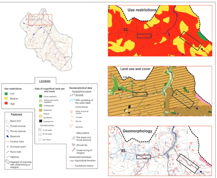
As they do not have direct use, valley bottoms will be dealt with by investigating use restric-tions, the surface use and cover of the land and the erosive features of the slopes on each side. To illustrate the issue, of the seven channels with undermining of the margins found in the Basin, three were selected that represent the problem in question (Figure 9).
In these areas, located in the north of the study area, in all sectors, it was verified that the
combination of the physical elements results in situations of high use restriction, which are almost
all covered by pasture (Figure 9) and are catalysts of the erosive processes in both areas classified as intensely altered (Figure 6) and exhausted (Figure 7). Such situations cause a greater superficial
discharge of rainwater, which, when reaching the valley bottoms readjusts the channel through the undermining of the banks. In the main channel, which receives all the tributaries with undermining
of the margins, the size of the terrace area and fluvial plain is noteworthy, due to the greater amount
.ufc.br
Environmental Analysis Through Network Graphics
Figure 9 - Restrictions on the use and use of land in the surroundings of channels with overlapping margins.
In an analysis of changes in relief in the Basin, from 1962 to 2013, Zanatta et al., (2015)
iden-tified that the plane and fluvial terrace areas increased by 1.73 times as a result of the excessive
sedimentation of the valley bottoms, while the number of fluvial channels increased from 29 seg
-ments to 71. This increase in the number of channels, concomitant to the formation and development
of the erosive processes in the study area, contradicts some known aspects of the effect of these
alterations on the drainage dynamics, since, instead of the burial of the springs, the data point to the
formation of first order channels. According to the study, the following hypothesis is considered,
[...] that this geomorphological phenomenon occurs due to the natural evolution of the landscape, related to linear erosive processes and the lithological characteristics of the Adamantina Formation, located on the highest lands of the basin, where the springs arise. The lithofacies of this formation,
which originate the first water table in the intercalation of sandstone banks with clayey silts, when subjected to the intense action of superficial and subsurface erosive processes, promote the exposure of these water tables with greater ease and, consequently, increase the number of first order channels
(ZANATTA, 2014, p.113).
It is evidenced that the inappropriate use of the soil interferes directly in the quality of the
Basin’s water resources. The activation of the erosive processes on the tops and slopes, as a way of adapting the physical environment to the covers that offer low protection to the soils and to the excessive use of the land, modified and modify the valley bottoms in the same intensity, either
through the re-adaptation of the network drainage, by increasing the first order channels, by exces
www
.mercator
FINAL CONSIDERATIONS
The use of network graphs, associated with cartographic spatialization in the analysis of the
Basin’s problem, was relevant in the quantification and evaluation of the combinations of physical and anthropic elements that result in different classes of environmental status. This representation
facilitated the interpretation of the erosive problem of the Basin and the elaboration of the envi-ronmental diagnosis by synthesizing a large volume of information and, through the links between these elements, indicates the catalysts of erosive processes, allowing the elements driving the system
to be verified.
The data show that the contribution of anthropic interference to the Basin’s erosive problem is significant, since only 4.35% of the study area is between the optimized and compensated states,
with uses adequate to the physical characteristics, which represents 95.65% in inappropriate uses,
of which 2.86% were exhausted, where the original morphology had been modified by the intense
erosive activity. It is also worth noting that the problem of these areas in an exhausted state is more
worrying when verifying the edge effect of gullying processes, that result in headward erosion by the appearance of ravines on the sides in higher sectors. Such situations still have a significant impact
on the valley bottoms, and consequently on the water quality of the Basin, either by undermining the banks in the tributaries, or by the silting of the main channels.
Given the demonstrated inadequacy between the actual use and the restrictions on the use of the area, this relationship violates the Federal Constitution of 1988, which, in Art. 225, Chapter
VI, states that:
everyone has a right to an ecologically balanced environment, which is for common use and is essential to a healthy quality of life, thereby the Government and society have the duty to protect it and preserve
it for the present and future generations. VI, Art. 225.
In addition, regarding the social function of rural property, the Constitution establishes the
need for the “appropriate use of available natural resources and preservation of the environment”
(BRASIL, 1988, Cap. III, Art.186, Section I), so that noncompliance with the social function of property may lead to expropriation by social interest, within the competence of the Union (BRASIL, 1988, Cap. III, Art.184. It is also necessary to consider all the land grabbing that marks the illegality
of private properties throughout Pontal do Paranapanema (FERRARI LEITE, 1998; THOMAZ Jr.,
2009).
.ufc.br
Environmental Analysis Through Network Graphics
BIBLIOGRAPHIC REFERENCE
BRASIL. Constituição (1988): Constituição da República Federativa do Brasil: promulgada em 5 de outubro de 1988. Disponível em: <http://www.planalto.gov.br/ccivil_03/constituicao/constituicaocompilado. htm>. Acesso em: 25 de abr. de 2015.
BRASIL. Câmara dos deputados. Proposta de Emenda à Constituição (PEC) 215 de 2000. Disponível
em: < http://www.camara.gov.br/proposicoesWeb/prop_mostrarintegra?codteor=889041>. Acesso em: 24
de abr. de 2015.
BRASIL, Lei 12.651, de 25 de maio de 2012. Institui o novo Código Florestal. [2012] Disponível em: <http://www.planalto.gov.br/ccivil_03/_ato2011-2014/2012/lei/l12651.htm>. Acesso em: 05 abr. 2015. BRASIL. Câmara dos deputados: Frente Parlamentar Agropecuária (FPA). Deputados e senadores ligados ao agronegócio. Disponível em: <http://www.camara.gov.br/internet/deputado/Frente_Parlamentar/356. asp>. Acesso em: 05 abr. 2015.
BOIN, M. N.; ZANATTA, F.A.S; CUNHA, C.M.L. Avaliação da morfometria do relevo da alta bacia hidro
-gráfica do ribeirão Areia Dourada, Marabá Paulista (SP). Caderno Prudentino de Geografia, Presidente
Prudente, v.2, p. 5-26, 2014.
CARVALHO, W. A. (coord.) Levantamento semidetalhado dos solos da bacia do rio Santo
Anastácio--SP. Presidente Prudente, São Paulo: FCT-UNESP, 1997, v.1 e v.2.
FAO (FOOD AND AGRICULTURE ORGANIZATION OF THE UNITED NATIONS). Status of the
World’s Soil Resources. Roma: Food and Agriculture Organization Nations, 2015.
FERRARI LEITE, J. A ocupação do Pontal do Paranapanema. São Paulo: HUCITEC, 1998. 202f.
INSTITUTO BRASILEIRO DE GEOGRAFIA E ESTATÍSTICA (IBGE). Manual técnico de uso da terra. Rio de Janeiro: IBGE, 2006. 171p.
LEAL, A. C. Meio Ambiente e Urbanização na microbacia do Areia Branca – Campinas, SP. 152p. Dissertação (Mestrado em Geociência e Meio Ambiente), Instituto de Geociências e Ciências Exatas, Uni-versidade Estadual Paulista, Rio Claro, 1995.
MATEO-RODRIGUEZ, J.M.; SILVA, E. V.; CAVALCANTI, A. O. B. Geoecologia das paisagens: uma
visão geossistêmica da análise ambiental. Fortaleza: Editora UFC, 2004.
MONBEIG, P. Pioneiros e Fazendeiros de São Paulo. São Paulo: HUCITEC, 1984. 392f.
PORTO-GONÇALVES, C. W. Geografia da riqueza, fome e meio ambiente: pequena contribuição crítica
ao atual modelo agrário/agrícola de uso dos recursos naturais. Florianópolis: INTERthesis, v. 1, n.1, 2004.
PORTO-GONÇALVES, C. W.; ALENTEJANO, P. R. R. A violência do latifúndio moderno-colonial e do
agronegócio nos últimos 25 anos. Comissão Pastoral da Terra: Conflitos no Campo Brasil, v. 1, p.
109-117, 2019.
PORTO-GONÇALVES, C. W. Amazônia, Amazônias. 3ª edição. São Paulo: Contexto, 2012. 177f.
SAMPAIO, P. A. Proposta de Plano Nacional de Reforma Agrária. Revista da Associação Brasileira de
Reforma Agrária. São Paulo, n. 1, v. 32, 2005.
SILVA, E.V.; MATEO-RODRIGUEZ, J.M.M. Planejamento e zoneamento de bacias hidrográficas: a geo
-ecologia das paisagens como subsídio para uma gestão integrada. Caderno Prudentino de Geografia. Presidente Prudente, n.36, v. especial, p.4-17, 2014.
STEIN, D. P. Avaliação da degradação do meio físico. Bacia do rio Santo Anastácio. Oeste Paulista. 197p. Tese (Doutorado em Geociências e Meio Ambiente), Instituto de Geociências e Ciências Exatas, Universidade Estadual Paulista, Rio Claro, 1999.
THOMAZ JR, A. Dinâmica geográfica do trabalho no século XXI: Limites explicativos, autocrítica e
desafios teóricos. 503p. Tese (Livre-docência). Faculdade de Ciências e Tecnologia, Universidade Estadual
Paulista, Presidente Prudente, 2009.
www
.mercator
ZANATTA, F.A.S. Diagnóstico visando planejamento ambiental da alta bacia do ribeirão Areia
Doura-da, Marabá Paulista (SP). 142p. Dissertação (Mestrado em Geografia – Organização do Espaço). Instituto
de Geociências e Ciências Exatas, Universidade Estadual Paulista, Rio Claro, 2014.
ZANATTA, F.A.S.; LUPINACCI, C. M.; BOIN, M. N. O uso da terra e alterações do relvo na alta bacia do ribeirão Areia Dourada, Marabá Paulista (SP): um estudo a partir de princípios da antropogeomorfologia.
Revista Brasileira de Geomorfologia. São Paulo, v.16, n.1, p.03-17, 2015.
ZANATTA, F.A.S.; LUPINACCI, C.M.; BOIN, M.N. Geoecologia da paisagem x Legislação ambiental: uma
análise da distribuição espacial das restrições ao uso da terra frente à problemática erosiva da alta bacia do