Geographic Sciences
C´edric Grueau and Jo˜ao Araujo
AbstractAgent-Based Modeling (ABM) and simulation have gained popularity in the Geographic Information Systems (GIS) domain. Despite the increasing number of models built by experts and users, it remains challenging for users to specify their models in a manner in which one can understand it. This constraint represents an inhibition to the development and acceptance of the ABM approach. In this paper, we raise the questions that need to be answered in order to cope with ABM speci-fication issues. We review some of the existing solutions that have been developed. We propose a framework that includes a domain specific modeling language to re-spond to ABM specification problem. We finally present the first step towards its development.
Key words: Domain ontology, Agent-Based Modeling, Domain Specific Modeling Language, Geographic Information Science
C´edric Grueau
NOVA Laboratory for Computer Science and Informatics, Departamento de Inform´atica, Faculdade de Ciˆencias e Tecnologia, Universidade Nova de Lisboa,
Quinta da Torre, 2829-516 Caparica, Portugal e-mail: [email protected]
Jo˜ao Araujo
NOVA Laboratory for Computer Science and Informatics, Departamento de Inform´atica, Faculdade de Ciˆencias e Tecnologia, Universidade Nova de Lisboa,
Quinta da Torre, 2829-516 Caparica, Portugal e-mail: [email protected]
Copyright c by the paper’s authors. Copying permitted for private and academic purposes. In: A. Comber, B. Bucher, S. Ivanovic (eds.): Proceedings of the 3rd AGILE Phd School, Champs sur Marne, France, 15-17-September-2015, published at http://ceur-ws.org
1 Introduction
In the Geographic Information Systems (GIS) domain, Spatial Modeling and Spatial Simulation are processes conducted by users of an information system in order to understand phenomenons and plan ahead.
From the different types of models used in the GIS community, Agent-Based Models (ABMs) have become a popular paradigm to perform spatial simulation. ABMS are employed to reason, experiment and extrapolate about systems. ABMs are designed and developed by representing the key decision-making entities as agents and by describing the environment in which they are interacting with a spa-tial model of the landscape. In the last decade, the degree of flexibility and the ability to represent social interactions induced multidisciplinary teams working in geographical sciences to develop different models based on agents. Through sim-ulation, experts can reproduce agents’ interactions over time to approach spatial problems. [11] , [8] and [1] provide a broad range of these applications.
But despite its high degree of flexibility, the agent approach presents some weak-nesses when it comes to re-using, implementing and evaluating models. Experts are experiencing difficulties to specify and share this type of model. They don’t have a common representation as it happens in the software community with the Unified Modeling Language (UML) for instance. Those weaknesses represent constraints and inhibitions to the development and acceptance of the ABM field. To cope with these limitations, the objective of our research project is to built a framework where experts could specify their ABM, store them and share them with the community of experts.
2 Related Work
[12] presented another interesting approach to address ABM transparency issues. The authors propose to implement ABM simulations using ontologies, instead of object-oriented languages. The body of work, cited above, represents a step forward to more transparent ABM. But they individually only respond partially to the issues we want to address in our research.
3 Research Questions
In order to respond to ABM specification issues, we propose to follow an approach that will address three questions. The first question is how to represent ABM infor-mation structure in a manner in which it is decoupled from the simulation software and can be independently processed. The second question to address relates to the level of abstraction to achieve in order to represent the concepts of the domain. In fact, the abstraction should enable to represent concepts and relationships for a mul-tidisciplinary audience who is not necessarily expert in computer science, but, at the same time be precise enough to represent all concepts of the domain. A third question to answer is which tools should be provided to users to create and explore ABM? Finally our research project should respond to a last question, which is, how can we ensure that an executable implementation conforms to a system’s model?
4 Method and Expected Results
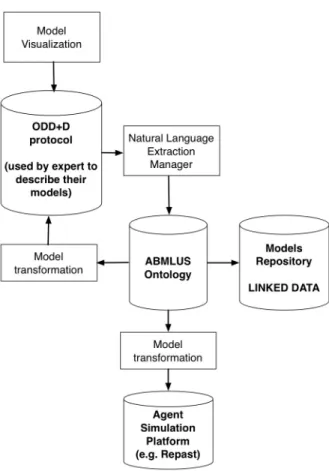
In order to respond to the questions raised above, we advocate the development of a framework (see figure 1) that would allow for specifying, exploring and export-ing ABM as linked data, usexport-ing the semantic web approach. This framework should integrate a domain specific language to manage models’ specifications and visu-alise agent-based models for the GIS domain. The DSML should be supported by a domain ontology that represents the main concepts used in ABM in GIS related sciences. Those are essentially concepts related with model scheduling and initiali-sation.
user. This widgets will implement visualisation of relevant aspects of the model such as maps, text and so on.
Fig. 1 Arquitecture for the proposed framework
By providing an agent-based modeling platform to the GIS community, we aim at empowering its users with a common platform to represent and communicate the systems and sub-models they are working on.
References
1. F. Bousquet and G. Tr´ebuil.Introduction to companion modeling and multi-agent systems for integrated natural resource management in Asia., pages 1–17. IRRI Publications, Los Banos, Philippines, 2005.
2. S. Christley, X. Xiang, and G. Madey. An ontology for agent-based modeling and simulation.
Agent 2004 Conference on Social Dynamics: Interaction, Reflexivity and Emergence, 2004. 3. V. Grimm, U. Berger, F. Bastiansen, S. Eliassen, V. Ginot, J. Giske, J. Goss-Custard, T. Grand,
S. K. Heinz, G. Huse, A. Huth, J. U. Jepsen, C. Jrgensen, W. M. Mooij, B. Mller, G. Peer, C. Piou, S. F. Railsback, A. M. Robbins, M. M. Robbins, E. Rossmanith, N. Rger, E. Strand, S. Souissi, R. A. Stillman, R. Vab, U. Visser, and D. L. DeAngelis. A standard protocol for describing individual-based and agent-based models. Ecological Modelling, 198(12):115 – 126, 2006.
4. V. Grimm, U. Berger, D. L. DeAngelis, J. G. Polhill, J. Giske, and S. F. Railsback. The odd protocol: A review and first update.Ecological Modelling, 221(23):2760 – 2768, 2010. 5. N. Guarino. Formal Ontology in Information Systems: Proceedings of the 1st International
Conference June 6-8, 1998, Trento, Italy. IOS Press, Amsterdam, The Netherlands, The Netherlands, 1st edition, 1998.
6. G. Guizzardi.Ontological foundations for structural conceptual models. PhD thesis, Univer-sity of Twente, Enschede, The Netherlands, October 2005.
7. G. Guizzardi and G. Wagner. Towards an ontological foundation of agent-based simulation. InWinter Simulation Conference, pages 284–295, 2011.
8. A. Heppenstall, A. Crooks, L. See, and M. Batty, editors. Agent-based Models of Geographical Systems. Springer: Dordrecht. Publication, 2012. http://www.springer.com/social+sciences/population+studies/book/978-90-481-8926-7. 9. B. M¨uller, F. Bohn, G. Dreß ler, J. Groeneveld, C. Klassert, R. Martin, M. Schl¨uter, J. Schulze,
H. Weise, and N. Schwarz. Describing human decisions in agent-based models - ODD+D, an extension of the ODD protocol.Environmental Modelling and Software, 48:37–48, 2013. 10. D. C. Parker, D. G. Brown, J. G. Polhill, and P. J. M. Deadman. Agent-Based Modelling
in Natural Resource Management, chapter Illustrating a new conceptual design pattern for agent-based models of land use via five case studies: the MR POTATOHEAD framework, pages 29–62. Valladolid, Spain, 2008.
11. D. C. Parker, S. M. Manson, M. A. Janssen, M. J. Hoffmann, and P. Deadman. Multi-agent systems for the simulation of land-use and land-cover change: A review. Annals of the As-sociation of American Geographers, 93(2):314–337, 2003. http://dx.doi.org/10.1111/1467-8306.9302004.
12. J. Polhill and N. Gotts. Ontologies for transparent integrated human-natural system modelling.
Landscape Ecology, 24(9):1255–1267, Nov. 2009.