Universidade de Aveiro Ano 2018
Departamento de Biologia
INÊS ALVES DOS
SANTOS TEIXEIRA
GOMES
CONECTIVIDADE
E
AVALIAÇÃO
BIOLÓGICA;
FERRAMENTAS PARA AVALIAR A COERÊNCIA
ECOLÓGICA DE REDES DE ÁREAS MARINHAS
PROTEGIDAS
CONNECTIVITY AND BIOLOGICAL VALUATION;
TOOLS
TO
ASSESS
THE
ECOLOGICAL
COHERENCE
OF
NETWORKS
OF
MARINE
Universidade de Aveiro Ano 2018
Departamento de Biologia
INÊS ALVES DOS
SANTOS TEIXEIRA
GOMES
CONECTIVIDADE E AVALIAÇÃO BIOLÓGICA;
FERRAMENTAS
PARA
AVALIAR
A
COERÊNCIA ECOLÓGICA DE REDES DE
ÁREAS MARINHAS PROTEGIDAS
CONNECTIVITY
AND
BIOLOGICAL
VALUATION;
TOOLS
TO
ASSESS
THE
ECOLOGICAL COHERENCE OF NETWORKS
OF MARINE PROTECTED AREAS
Tese apresentada à Universidade de Aveiro para cumprimento dos requisitos necessários à obtenção do grau de Doutor em Ciências do Mar, realizada sob a orientação científica do Professor Doutor Henrique José de Barros Brito Queiroga, Professor Associado com Agregação do Departamento de Biologia da Universidade de Aveiro e co-orientação da Professora Doutora Ann Vanreusel, Professora Catedrática do Departamento de Biologia da Universidade de Ghent, Bélgica.
This work was funded by Fundação para a Ciência e Tecnologia FCT research project 'LarvalSources - Assessing the ecological performance of marine protected area networks' (PTDC/BIA-BIC/120483/2010) and through a MARES PhD Grant (MARES_12_10). MARES is a Joint Doctorate programme selected under Erasmus Mundus coordinated by Ghent University (FPA 2011-0016).
o júri
presidente Professor Doutor Amadeu Mortágua Velho da Maia Soares
Professor Catedrático da Universidade de Aveiro
vogais Professor Doutor Henrique Manuel Roque Nogueira Cabral
Professor Catedrático da Universidade de Lisboa
Professor Doutor Karim Erzini
Professor Associado com Agregação da Universidade do Algarve
Professora Doutora Maria De Fátima Lopes Alves
Professora Auxiliar c/ Agregação da Universidade de Aveiro
Professor Doutor Steven Degraer
Professor Convidado da Universidade de Ghent, Bélgica
Professor Doutor Jan Vanaverbeke
Professor Convidado da Universidade de Ghent, Bélgica
Professor Doutor Henrique José De Barros Brito Queiroga (orientador)
Agradecimentos/ Acknowledgements
“The fun factor isn’t essential to creative work, (...) but sometimes when we’re playing around with ideas and laughing, we’re most open to new thoughts. In all creative work, there may be frustrations, problems, and dead ends along the way. (...) However, there’s always profound pleasure at some point, and a deep sense of satisfaction from “getting it right.”
Ken Robinson, The Element: How Finding Your Passion Changes Everything.
Ken Robinson is one of the greatest communicators I know. I deeply share his ideas on education and creativity. In science, as in arts and life itself, answering difficult questions involves re-imagining complex problems, creatively formulating new ideas and connections to find ways to solve them. In this sense, I am genuinely grateful to have been given the opportunity to work with such an amazing group of people, who valued science, creativity and a good laugh.
Thank you, Professor Henrique Queiroga, for leading the way. For being there since day one; in the next table, in the office upstairs, or a telephone or Skype call away. Thank you for your guidance, your positive attitude, leadership and your trust in me. Also, thanks to professor Ann Vanreusel for making me feel welcome at the UGent Marine Biology research group and all your assistance and logistical support. I would also like to express a special thank you to professor Stephen Swearer, Dr. Rita Nolasco and professor Jesus Dubert for your constructive attitude, suggestions and corrections, and Klaas Deneudt for your help, hard work and expertise.
To the MARES consortium, thank you for your vision and for funding this research. It has been a privilege to follow your initiatives, and I can only hope to continue using my skills for the purpose that has united us from the beginning: Marine Conservation. A special thank you to the personnel at UGhent Child Care for your help in making it all so natural and simple. Also, thank you Alexandra Elbakyan, creator of Sci-Hub, for fighting for equal access to scientific information, and for allowing me to work from many desks, in many places.
Graciñas Laura Peteiro, my post doc, mussel, statistical and good vibe guru. Every time we seemed to be reaching a dead end, you took a moment, looked at me with your big eyes, smiled and said “I have an idea”. Every. Time. And the entire thesis-world brightened up. This thesis wouldn’t have been half complete (or half fun) if it wasn’t for you. You are part of my tribe, and an inspiration. Remember when we were so sleepless from fieldwork that we decided to take a 5-day break to a mussel-free zone and booked tickets to the middle of the Atlantic, where NO mussel has ever settled (or so we think). That is how we rolled.
Agradecimentos/ Acknowledgements (cont.)
Rui Albuquerque, primo, thanks for being an amazing lab mate; for your hard work in the express trips to Australia, and for all the productive and fun times during field work. I miss our cool scientific and Benfica-Sporting wanderings over a cold beer and uma empalhada ;)
Laura, Rui, it’s hard to articulate how close we get after stopping at 1am at a gas station, to fertilize mussel eggs under the moonlight, in the back of our van.
To the Aveiro University lab gang Pedro, Gina, Felisa, Gabriela and Juan, thanks for an amazing lab environment and for all the scientific and non-scientific debates over coffee-breaks. And to the non lab UA gang, Marta, Luciana, Ana Sousa, Ana Hilário, Sofia, Valentina, Veronica. And thank you to the MARES gang, the EMBC gang (Ruhama, Lia and Eva, for always being one click away), the Faro gang, the Canarias gang, the Kenya gang, and more recently, to the Açores gang. You keep me going. And you keep me coming back. And thank you Mpaji, for showing me the true meaning of resilience.
Lastly, a special thanks to all my family crew. My parents, for giving me the freedom to fly, enjoy the most amazing views, fall and get up. And repeat. Thank you for giving me such a powerful background on freedom, curiosity and profound respect for people and nature.
Sergi, thanks for being an amazing person. Day. After. Day. With you, I learned to overcome my fear of excel spreadsheets, and rediscover science. And love. It has been an amazing ride. Finally, Gael, thanks for joining us somewhere between chapters IV and V of this thesis. You have already become the most amazing and gratifying episode of our lives.
palavras-chave
resumo
Redes de Áreas Marinhas Protegidas; Coerência Ecológica; Conectividade; Representatividade; Etiquetas naturais; Veículos aéreos não tripulados; Modelos Biofíscos; Avaliação Biológica Marinha.
A pressão internacional para encontrar abordagens ecossistémicas eficazes para evitar, reduzir e compensar o impacto das atividades humanas na saúde global dos oceanos, está a aumentar. Nesse sentido, as principais políticas marítimas europeias e de outras agências internacionais, defendem a necessidade de estabelecer redes ecologicamente coerentes de áreas marinhas protegidas (AMPs).
Atingir a coerência ecológica é, no entanto, uma tarefa complexa dada a magnitude do conceito e a falta de definições operacionais objectivas. Deste modo, avaliar a coerência ecológica requer abordagens múltiplas para analisar a localização, tamanho e espaçamento entre áreas protegidas já selecionadas, mas também para inferir sobre a designação de novos locais e melhor a performance da rede. O objetivo desta tese é desenvolver e utilizar diferentes ferramentas de forma a apoiar e promover uma avaliação da coerência ecológica da rede de AMPs em Portugal continental.
Este trabalho utilizou três métodos complementares para estimar conectividade larvar ao longo da costa oeste portuguesa, usando o mexilhão Mytilus galloprovincialis como espécie-modelo. O primeiro método retrata o uso de etiquetas geoquímicas naturais para fazer o rastreo da origem natal de mexilhões, quantificando padrões de conectividade demográfica (trajetórias de dispersão e distâncias). Concentrou-se nas AMPs da Arrábida e Berlengas, salientando a importância das populações que servem como fonte de indivíduos para dispersão e auto-recrutamento dentro das AMPs. O segundo método resultou da necessidade de quantificar a cobertura de mexilhão no intermareal rochoso, para futura aplicação em modelos de dispersão larvar de larga escala. O uso de imagens aéreas de baixa altitude e de alta resolução, modelos de superfície tridimensionais e de observações in situ, provaram ser uma ferramenta viável para monitorizar ecossistemas intermareais numa escala espacial ecologicamente relevante. O efeito de variáveis ambientais (complexidade do substrato e exposição às ondas) na densidade e tamanho do mexilhão foi também investigado. A densidade máxima de mexilhão no substrato rochoso ocorreu com valores intermédios de exposição às ondas no Inverno, enquanto que altos valores de exposição às ondas resultaram num menor tamanho dos mexilhões.
resumo (cont.)
No terceiro estudo, a combinação das estimativas empíricas de conectividade, com parâmetros demográficos (fertilidade, comportamento larval, mortalidade) permitiram a validação de um modelo numérico biofísico de larga escala. Este modelo integrou informações oceanográficas, demográficas e de biologia larvar, para simular a dispersão de larvas de M. galloprovincialis ao longo da costa oeste da Peninsula Ibérica. O modelo incorporou e simulou também a incerteza associada à atribuição da origem das populações referente ao método geoquímico. Os resultados demonstraram altos níveis de correspondência entre as estimativas independentes de conectividade a uma pequena escala espacial. Este modelo validado pode ser usado no futuro para investigar dinâmicas metapopulacionais com aplicações em estratégias de gestão de AMPs.
Finalmente, utilizou-se uma abordagem ecológica para valorizar a biodiversidade marinha ao longo da plataforma continental portuguesa. Este protocolo de avaliação biológica integrou informações biológicas e ecológicas espaciais, para diversos componentes do ecossistema. Os resultados foram ilustrados num mapa global de valor biológico marinho, destacando hotspots de significância ecológica. Este estudo avaliou também em que medida as zonas de alto valor biológico estavam incluido nas áreas protegidas da rede Natura 2000 em Portugal (actuais e propostas).
Ao integrar a informação das vias de conectividade marinha, com uma ampla avaliação biológica da costa portuguesa, esta tese procura contribuir para os critérios de avaliação de redes de AMPs e dar um passo em frente no sentido de o tornar aplicável ao panorama português.
keywords
abstract
Marine Protected Areas; Networks; Ecological Coherence; Connectivity; Representativity; Natural tags; Unmanned Aerial Vehicles; Biophysical modeling; Marine Biological Valuation.
In order to avoid, reduce and offset the impact that human activities are having on the health of the world's oceans, the international demand for a successful ecosystem-based approach to the marine environment is growing in popularity. Major European maritime policies and other international agencies advocate that, in order to effectively protect the marine environment, there is a need to establish ecologically coherent networks of marine protected areas (MPAs). Achieving ecological coherence is, however, a complex task given the magnitude of the concept and the lack of clear operational definitions. Therefore, assessing ecological coherence requires multiple approaches to analyse not only the location, size and spacing of protected sites already selected for protection, but also infer about new sites to enhance network effects. The aim of this thesis is to develop and use different tools to assist, support and help to promote the assessment of the ecological coherence of networks of MPAs, with a focus on continental Portugal.
Three complementary methods were applied using the mussel Mytilus galloprovincialis as a model species to estimate connectivity via larval dispersal along the Portuguese west coast. The first study described the use of natural geochemical tags to trace back natal origins of mussels and describe direct measures of demographic connectivity patterns (dispersal trajectories and distances). It focused in the Arrábida and Berlengas Marine Protected Areas (MPAs) and emphasized the significance of source and sink populations and self-recruitment within MPAs. The second study resulted from the need to quantify mussel bed coverage in order to apply the connectivity estimates into broader scale models of larval dispersal. The use of low altitude and high-resolution drone imagery, 3D surface models and ground-based observations proved to be a viable and powerful tool for surveying intertidal ecosystems at an ecological relevant spatial scale. The effect of environmental variables (substrate complexity and wave exposure) on mussel density and size was also investigated. Maximum mussel density occurred at intermediate values of wave exposure in winter while smaller sized mussels prevailed at high values of wave exposure.
abstract
(cont.) The combination of the empirical connectivity estimates, with mussel demographic and biological parameters (reproductive output, larval behaviour, mortality) allowed the validation of a broad scale numerical biophysical model in the third study This model combined oceanographic and demographic information with larval biology, and was used to simulate dispersal of M. galloprovincialis larvae along the Western Iberian coast. The biophysical model simulated and accounted for uncertainty of the geochemical method in the assignment of source populations and resulted in unprecedented levels of correspondence among independent connectivity estimates at small spatial scales. This fine-tuned model can be used in the future to investigate metapopulation dynamics with applications in MPA management strategies. Finally, a quantitative-based ecological approach was used to value biodiversity along the Portuguese continental shelf. The marine biological valuation protocol summarized and combined existing biological and ecological spatial information of different ecosystem components into an overall map of marine biological value, highlighting hotspots of ecological significance. This study also evaluated the extent to which high biological value was contained in the current and projected Natura 2000 sites in Portugal.
By integrating the information of marine connectivity pathways, with a broad biological assessment of the Portuguese coast, this thesis seeks to build upon existing MPA assessment criterion and take a step forward in making it practical and applicable to the Portuguese setting.
Sleutelwoorden Ecologische coherentie, beschermde zeegebieden, netwerken, connectiviteit, representativiteit, natuurlijke merkers, drones, biofysische modellering, biologische waardebepaling van zeegebieden
abstract
De internationale vraag naar een succesvolle ecosysteem-gebaseerde aanpak om de impact van menselijke activiteiten op de gezondheid van de oceanen te vermijden, te reduceren of te compenseren, neemt toe in populariteit. Belangrijke Europese maritieme beleidsinstanties en andere internationale agentschappen benadrukken dat het oprichten van ecologisch coherente netwerken van beschermde zeegebieden noodzakelijk is om het mariene milieu doeltreffend te beschermen.
Echter, het bereiken van ecologische coherentie is een complexe taak gezien het ruime concept en het ontbreken van eenduidige operationele definities. Het vaststellen van ecologische coherentie vereist dus verschillende benaderingen. Op die manier kan niet alleen de locatie, de grootte en afstand van reeds geselecteerde gebieden voor bescherming bepaald worden, maar ook nieuwe locaties die het netwerkeffect versterken. Het doel van deze thesis is het ontwikkelen en toepassen van verschillende methodes als hulpmiddel om de ecologische samenhang van beschermde zeegebieden te promoten, en dit met focus op het Portugese continentale plat.
Drie complementaire methodes werden toegepast om de connectiviteit via larvale dispersie in te schatten langs de Portugese westkust en dit telkens toegepast op de mossel Mytilus galloprovincialis als modelorganisme. De eerste studie beschrijft het gebruik van natuurlijk voorkomende geochemische tracers om de oorsprong van de mossels te achterhalen en documenteert dus de demografische connectiviteitspatronen (verspreidingsroutes en afstanden). De focus lag op de beschermde zeegebieden van Arrábida en Berlengas, en benadrukte het belang van ‘source–and–sink’ populaties en zelf-recrutering binnen de beschermde gebieden. In een tweede studie werd de oppervlakte van mosselbedden gekwantificeerd zodat de connectiviteitsschattingen konden toegepast worden op modellen van larvale dispersie op grotere schaal. Het gebruik van beeldmateriaal met hoge resolutie verzameld door drones op lage hoogte, 3D-oppervlakte modellen en veldobservaties bleek een efficiënte methode om intertidale ecosystemen te bestuderen op een ecologisch relevante schaal. De combinatie van empirische connectiviteitsschattingen en demografische en biologische parameters (oppervlakte van mosselbedden, gedrag van larves, mortaliteit, reproductieve output en timing) laat de validatie toe van een grootschalig numeriek, biofysisch model. Het effect van de omgevingsvariablen (zoals substratum complexiteit en blootstelling aan golven) op de mosseldichtheid en -grootte werd ook onderzocht. Maximum mosseldichtheid kwam voor bij intermediaire waarden van golfblootstelling in de winter en kleinere mosselen domineerden bij hoge waarden van blootstelling aan golven.
abstract (cont.)
Dit model combineert oceanografische en demografische informatie met larvale biologie, en werd gebruikt om de dispersie van M. galloprovincialis larven langs de West-Iberische kust te simuleren. Het biofysisch model hield rekening met de onzekerheid van de geochemische methode in het toekennen van de ‘source’ populaties en resulteerde in ongeziene overeenkomsten tussen de onafhankelijke connectiviteitsschattingen op kleine schaal. Vanaf nu kan dit verfijnde model gebruikt worden om de dynamieken van metapopulaties te onderzoeken en kan het dus bijdragen aan weldoordachte strategieën met betrekking tot het oprichten van beschermde zeegebieden
Tot slot werd een kwantitatief-gebaseerde ecologische aanpak gebruikt om de biodiversiteit te bepalen langs het Portugees continentaal plat. Het protocol voor mariene biologische waardebepaling combineerde bestaande biologische en ecologische informatie van verschillende subzones in een kaart die de biologische waardebepaling weergeeft, en hotspots van ecologisch belang identificeert. Deze studie evalueerde ook de mate waarin grote biologische waarde vervat zit in de huidige en toekomstige Natura 2000 gebieden in Portugal.
Door het integreren van informatie over mariene connectiviteitsroutes, met breed biologisch onderzoek langs de Portugese kust, bouwt deze thesis verder op het bestaande criterium voor de selectie van beschermde gebieden, en maakt het praktisch en toepasbaar voor Portugal.
Connectivity and Biological valuation:
tools to assess
the ecological coherence of networks of marine protected
areas
“If we knew what it was we were doing
it would not be called research, would it?”
I
Table of Contents
Thesis Overview ... 1
Chapter I – Introduction ... 7
1.1 The evolution of MPAs as conservation management tools ... 9
1.2 From individual MPAs to Networks of MPAs ... 13
1.3 The concept of Ecological coherence for networks of MPAs ... 18
1.4 Criteria used to assess the degree of ecological coherence of networks of MPAs .... 20
1.4.1 Representativity ... 20
1.4.2 Replication ... 21
1.4.3 Adequacy ... 21
1.4.4 Connectivity ... 21
1.5 Design and practical assessments of ecological coherence of networks of MPAs ... 22
1.6 Challenges and limitations in assessing ecological coherence of networks of MPAs. 27 1.7 References ... 31
Chapter II – Wandering mussels: using natural tags to identify connectivity patterns among Marine Protected Areas ... 41
Abstract ... 43
2.1 Introduction ... 44
2.2 Material and Methods ... 46
2.2.1 Species description ... 46
2.2.2 Area description ... 47
2.2.3 Mussel spawning and in situ larvae incubation ... 48
2.2.4 Mytilid larval and juvenile shell extraction and cleaning ... 50
2.2.5 LA-ICPMS analysis ... 50
2.2.6 Environmental Data ... 52
2.2.7 Statistical Analysis ... 53
2.3 Results ... 54
2.3.1 Larvae incubation and creation of an atlas of natal signatures... 54
2.3.2 Establishment of natal origin of juveniles ... 60
2.3.3 Environmental data ... 64
2.4 Discussion ... 66
2.4.1 Larval-shell geochemical signatures ... 66
II
2.4.3 Implications for management and future directions ... 70 2.5 References ... 71 Chapter III – What’s a picture really worth? On the use of drone aerial imagery to estimate intertidal rocky shore demographic parameters... 77 Abstract ... 79 3.1 Introduction ... 80 3.2 Material and Methods ... 83 3.2.1 Study area and species description ... 83 3.2.2 Drone flight, imagery and model methodology ... 85 3.2.2.1 Image acquisition ... 85 3.2.2.2 Image processing ... 86 3.2.2.3 Image classification ... 86 3.2.2.4 Classification accuracy assessment ... 87 3.2.2.5 Mussel estimates ... 88 3.2.3 Environmental variables ... 89 3.2.3.1 Wave Fetch ... 89 3.2.3.2 Wind Energy ... 90 3.2.3.3 Wave Exposure Index (WEI) ... 90 3.2.3.4. Terrain Roughness Index (TRI) ... 90 3.2.4 Spatial Extrapolation ... 90 3.3 Results ... 91 3.3.1 Image processing and classification ... 91 3.3.2 Environmental variables ... 95 3.3.3 Generalized additive models ... 97 3.4 Discussion ... 102 3.4.1 Drone aerial survey estimates ... 102 3.4.2 Model estimates ... 104 3.5 Conclusions ... 107 3.6 References……… 106 3.7 Supplementary Information 1 - Orthophoto mosaics, classified images, digital
elevation models (DEM) and terrain roughness index ... 115 3.8 Supplementary Information 2 - Error matrices ... 122 Chapter IV –Independent estimates of marine population connectivty are more concordant when accounting for uncertainties in larval origins ... 125 Abstract ... 127
III 4.1 Introduction ... 128 4.2 Methods ... 132
4.2.1 Elemental fingerprinting and the generation of observed connectivity
matrices ... 132 4.2.2 Biophysical numerical model and the generation of modelled connectivity matrices ... 136 4.2.3 Accounting for uncertainty: recruit origin and the construction of observed and modelled connectivity matrices ... 137 4.2.4 Accounting for uncertainty: mussel biology scenarios ... 140 4.2.5 Arrangement of the core matrix ... 140 4.3 Results ... 141 4.3.1 Generation of observed and modelled connectivity matrices ... 141 4.3.2 Assessing the causes of convergence between observed and modelled connectivity matrices ... 146 4.4 Discussion ... 152 4.4.1 Comparison between observed and modelled connectivity matrices ... 152 4.5 Future directions ... 154 4.6 References ... 155 4.7 Supplementary Information 1: Literature review ... 162 4.8 Supplementary Information 2: Biophysical model ... 172 4.9 Supplementary Information 3: Matrix correlations ... 178 4.10 Supplementary Information 4: Matrix adjustment ... 181 4.11 Supplementary Information 5: Prediction 1 ... 182 4.12 Supplementary Information 6: Prediction 2………...……….… 186 Chapter V – Marine biological value along the Portuguese continental shelf; insights into current conservation and management tools ... .187 Abstract ... 189 5.1 Introduction ... 190 5.2 Material and Methods ... 193 5.2.1 Study area ... 193 5.2.2 Databases ... 195 5.2.3 Marine Biological Valuation protocol ... 198 5.2.4 Hotspot identification ... 199 5.2.5 Spatial overlap ... 200
IV
5.2.5.1 Conservation areas ... 200 5.2.5.2 Habitat maps ... 201 5.3 Results ... 201 5.3.1 Biological Value (BV) and Hotspots classification ... 201 5.3.2 Spatial Overlaps ... 205 5.3.2.1 – Conservation areas ... 205 5.3.2.2–Habitat maps ... 207 5.4 Discussion ... 209 5.4.1 BV per ecosystem component ... 209 5.4.2 Total BV and biodiversity hotspots ... 212 5.4.3 Limitations and opportunities ... 213 5.4.4 Overlap with conservation areas ... 214 5.4.5 Management Implications ... 215 5.5 Conclusions ... 217 5.6 References ... 217 5.7 Supplementary Information: Assessment questions, data availability, data reliability and biological value scores ... 224 5.8 Supplementary Information: Natura 2000 Network sites in continental Portugal .. 226 5.9 Supplementary Information: Results for the birds component ... 227 5.10 Supplementary Information: Results for the demersal fish component ... 228 5.11 Supplementary Information: Results for the macrobenthos component ... 229 5.12 Supplementary Information: Results for the marine mammal and turtle component ... 230 Chapter VI – General discussion and future directions ... 231 6.1 General Discussion ... 233 6.2 Future directions and final remarks ... 242 6.3 References ... 245
Thesis Overview
1 Thesis Overview
Assessing ecological coherence of networks of Marine Protected Areas (MPAs) is a contemporary issue. Major European and other international agencies advocate that, in order to effectively protect the marine environment, a network of MPAs needs to be ecologically coherent. To achieve this goal, four main factors need to be taken into consideration: connectivity, adequacy, representativity, and replication. However, given the magnitude of the concept and the lack of clear operational definitions, building a coherent network of MPAs is a challenge. The aim of this thesis is not to provide an absolute assessment of “coherency” within the network of MPAs in Portugal, but rather to use and develop different tools to assist, support and help to promote this complex but crucial task.
The criteria of connectivity, adequacy, representativity, and replication ultimately reflect ideal MPA size, spacing, shape and the distribution and ecology of species and habitats at different scales. These concepts are reviewed in Chapter I, together with an overview of threshold levels used to assist in the guidance and measurement of coherence. This chapter highlighted the international pressure and the current constraints to set up coherent networks of MPAs so as to protect the structures and functions of marine systems, and promote economic and social benefits in an integrative manner. Also, it reflects on the current Portuguese situation in terms of marine protected areas’ implementation and management and the conservation strategies underlying the National Strategy for the Seas (ENM 2013-2020) and the Portuguese Natura 2000 sites. Chapters II to IV concentrate on tools to investigate population connectivity among MPAs, one of the overarching performance criteria of networks of MPAs. Three different but complementary methods were applied using the mussel Mytilus galloprovincialis as a model species to estimate larval dispersal along the Portuguese west coast. Chapter V, in turn, focuses on the intrinsic value incorporated in biodiversity per se, to detect hotspots of high biological value in the study area.
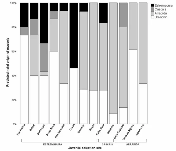
Chapter II describes the use of natural geochemical tags (of larval and recruit shells) to trace back natal origins of mussels and describe the connectivity patterns among the Arrábida and Berlengas Marine Protected Areas (MPAs) in the central Portuguese west coast. This chapter describes direct measures of demographic connectivity (dispersal trajectories and distances) for an important ecosystem engineer in rocky shores and emphasizes the significance of source and sink populations and self-recruitment within MPAs. Our results suggest that protected sites should be placed within around 50 km from each other to maximize benefits for mytilid marine larvae with potential large-scale dispersal among rocky intertidal areas.
Thesis Overview
2
Research Questions:
1. Are geochemical signatures in larval shells adequate to distinguish natal sources of mussel recruits (spatial scale of geochemical variability)?
2. What are the main dispersal trajectories and distances and how much self-recruitment occurs during the study period?
3. What is the degree of connectivity between the two Portuguese MPAs and among these and the remaining coast?
4. Are the results consistent with simultaneous environmental and oceanographic data?
Chapter III resulted from the need to quantify mussel bed coverage in order to apply the connectivity estimates into broader scale models of larval dispersal. This way, this chapter describes the use of low altitude and high-resolution drone imagery, 3D surface models and ground based observations as a viable and powerful tool for surveying intertidal ecosystems. Aerial images were mosaicked and georeferenced and a 3D photogrammetric model was reconstructed with a ground resolution of less than 1cm/pixel. Mussel coverage, density and mean size was then calculated for each location and modelled along the central Portuguese west coast as a function of a wave exposure index.
Research Questions:
1. Are low altitude-high resolution aerial images useful in investigating fine-scale rocky intertidal topography and mussel coverage in rocky intertidal shores?
2. Does combining aerial images with 3D photogrammetric models and ground-based quadrat sampling provide realistic measurements of mussel bed coverage, density and size?
3. Are wave exposure and terrain roughness good explanatory variables of mussel coverage and size?
Chapter IV puts together the results of Chapters II and III by comparing the empirical connectivity matrices obtained with geochemical tags with predicted connectivity matrices produced by a numerical biophysical model. This model combined oceanographic and demographic information with larval biology, which was used to simulate dispersal of M.
galloprovincialis larvae along the study area. In addition to predicting larval dispersal, this
chapter uses the biophysical model to simulate and account for uncertainty of the geochemical method in the assignment of recruits to putative source populations, thereby improving the cross-validation of two independent estimates of marine population connectivity.
Thesis Overview
3 Research Questions:
1. What is the current situation on scientific studies dealing with multiple methodological approaches to increase confidence in estimates of population connectivity?
2. Does accounting for uncertainties in larval origins derived from elemental chemistry improve concordance with predictions from a biophysical model of dispersal?
Chapter V explores a quantitative-based ecological approach which combines and spatially evaluates data for a wide taxonomic range of ecosystem components (seabirds, demersal fish and invertebrates, macrobenthos, marine mammals and sea turtles) at the scale of tens of kilometres. The Marine Biological Valuation (MBV) protocol was applied along the continental Portuguese continental shelf to create maps describing patterns of biological value and biodiversity hotspot areas. This study also considered the extent to which high biological value was contained in current Natura 2000 Special Protection Areas and projected Sites of Community Importance in Portugal.
Research Questions:
1. Which databases are available on the distribution and abundance of different ecosystem components (seabirds, demersal fish, macrobenthos, marine mammals and sea turtles) at the scale of tens of kilometres along the continental Portuguese shelf? 2. Does the data have enough spatial and temporal resolution to apply the marine
biological valuation protocol?
3. What is the spatial overlap of the high valuable areas (hotspots) with current and prospected marine conservation areas (Natura 2000 network)?
4. What is the significance of the results in the context of the Portuguese marine spatial planning and conservation strategies?
Finally, Chapter VI builds upon the overall findings and integrates and discusses the results within the context of the assessment of MPA networks at the national scale. It also briefly provides some general guidelines for future work, in order to use the best available scientific information for the design and assessment of the network. By integrating the information of marine connectivity pathways with a broad biological assessment of the Portuguese coast, this thesis hopes to assist in the ongoing process of MPA design and assessment and take a step forward in the guidance of conservation management applicable to the Portuguese setting.
Thesis Overview
4
The results of this thesis have been partially presented at various national and international conferences and published (or submitted) to peer-reviewed journals, as follows:
Peer reviewed publications:
Gomes I, Peteiro LG, Bueno J, Albuquerque R, Nolasco R, Dubert J, Queiroga H, 2018. What's a picture really worth? On the use of drone aerial imagery to estimate intertidal rocky shore demographic parameters (under review) Estuarine and Coastal Shelf Science. Gomes I, Pérez-Jorge S, Peteiro L, Andrade J, Bueno-Pardo J, Quintino V, Rodrigues AM,
Azevedo M, Vanreusel A, Queiroga H, Deneudt K, 2017. Marine biological value along the Portuguese continental shelf; insights into current conservation and management tools. Ecological Indicators, 93, 533-546https://doi.org/10.1016/j.ecolind.2018.05.040
Nolasco R, Gomes I, Peteiro L, Albuquerque R, Luna T, Dubert J, Swearer SE, Queiroga H, 2018. Independent estimates of marine population connectivity are more concordant when accounting for uncertainties in larval origins. Scientific Reports. 8 (1) pp: 2641
doi:10.1038/s41598-018-19833-w
Gomes I, Peteiro LG, Albuquerque R, Nolasco R, Dubert J, Swearer SE, Queiroga H, 2016. Wandering mussels: using natural tags to identify connectivity patterns among Marine Protected Areas. Marine Ecology Progress Series. 552, 159–176
https://doi.org/10.3354/meps11753
Oral communications:
Queiroga H, Gomes I. 2018. Valor biológico e conectividade populacional: ferramentas complementares para designar redes de áreas marinhas protegidas. Primeiro Congresso de Biologia Marinha dos Países de Língua Portuguesa. Faro, Portugal. (oral presentation) Gomes I, Peteiro L, Albuqerque R, Bueno J, Nolasco R, Dubert J, Swearer S, Queiroga H, 2017. Connectivity and Demographic insights of Mytilus galloprovincialis in the Portuguese west coast. 2nd International Symposium on the Advances in Marine Mussel Research. Sète, France. (oral presentation)
Andrade J, Albuquerque R, Azevedo M, Pardo JB, Deneudt K, Dubert J, Gomes I, Nolasco R, Perez S, Peteiro L, Quintino V,. Swearer SE, Vanreusel A, Queiroga H 2017. Biological value and population connectivity assessments: complementary tools to designate networks of MPAs. III Internacional Workshop LIFE+ MarPro. Ilhavo, Portugal. (oral presentation)
Thesis Overview
5 Gomes I, Peteiro LG, Bueno J, Albuquerque R, Nolasco R, Dubert J, Queiroga H, 2016. What's a picture really worth? On the use of drone aerial imagery to monitor intertidal rocky shores. MARES Conference II, Marine ecosystem Health and Conservation, Olhão, Portugal.
Nolasco R, Gomes I, Peteiro L, Albuquerque R, Dubert J, Swearer SE, Queiroga H, 2016. Accounting for uncertainty improves cross-validation of independent estimates of larval dispersal and population connectivity in a spatially structured marine metapopulation. Second Meeting of the International Marine Connectivity Network - iMarCo, St. Andrews, Scotland. (oral presentation)
Gomes I, Pérez-Jorge S, Peteiro L, Andrade J, Bueno-Pardo J, Quintino V, Rodrigues AM, Azevedo M, Vanreusel A, Queiroga H, Deneudt K, 2016. On the ecological coherence of Marine Protected Areas. Marine Biology Section lab Symposium. Ghent University, Belgium.
Gomes I, Peteiro LG, Albuquerque R, Bueno J, Pimentel J, Nolasco R, Dubert J, Swearer S, Queiroga H, 2015. Identificação de padrões de conectividade populacional entre áreas marinhas protegidas. I Jornadas do conhecimento da Reserva da Biosfera das Berlengas (UNESCO) Escola Superior de Turismo e Tecnologia do Mar. Peniche, Portugal.
Gomes I, Peteiro LG, Bueno J, Albuquerque R, Queiroga H, 2015. Quanto vale uma fotografia? Sobre o uso de drones na monitorização do intermareal rochoso. IV Encontro Nacional de Pós-graduação em Ciências Biológicas. Universidade de Aveiro, Portugal.
Gomes I, Peteiro LG, Albuquerque R, Swearer SE, Queiroga H, 2014. Wandering Mussels: using natural tags to identify connectivity matrices amongst Marine Protected Areas. MARES Conference I, Marine ecosystem Health and Conservation, Olhão, Portugal. (oral presentation)
Gomes I, Peteiro LG, Albuquerque R, Swearer SE, Queiroga H, 2014. Wandering Mussels: using natural tags to identify connectivity matrices amongst Marine Protected Areas. International Council for the Exploration of the Sea Annual Science Conference 2014 – Sustainabilty in a chaging ocean. La Coruña, Spain. (oral presentation)
Gomes I, Peteiro LG, Albuquerque R, Swearer SE, Queiroga H, 2014. Using trace element content in mussel larval shells to identify natal sources. Estuarine and Coastal Sciences Association Conference ECSA. Sesimbra, Portugal. (oral presentation)
Thesis Overview
6
Mussels used to map habitat connectivity of Natura 2000 marine sites in Portugal. 2016. Selected for publication in Science for Environment Policy information service. Published by the European Commission Directorate-General Environment, Issue 475.
Best oral presentation, under the theme Biodiversity Effects. 2016. MARES Conference II,
Marine ecosystem Health and Conservation, Olhão, Portugal.
Sesimbra Scientific Award and science outreach book publication.Gomes I, Peteiro LG,
Albuquerque R, Nolasco R, Dubert J, Swearer SE, Queiroga H, 2016. A viagem do mexilhão da Arrábida ou, como para viajar basta existir. 2015. Câmara Municipal Sesimbra.
Best PhD student oral presentation. 2015. Encontro Nacional de Pós-graduação em
Chapter I
7
Chapter I
Introduction
Overview of the current status of the criteria used to designate and assess networks of Marine Protected Areas (MPAs)Chapter I
Chapter I
9 1.1 The evolution of MPAs as conservation management tools
Coherent networks of MPAs in Europe have been largely driven by the Natura 2000 process, by regional seas conventions, and backed up by national legislations. Rather than exhaustingly define all criteria and target levels used in many contexts, and already reviewed in several policy documents, technical reports and publications (see Ardron 2008, HELCOM 2010, Olsen et al. 2013, Wolters et al. 2015), this section focuses on key guiding principles and criteria supporting the design and assessment of the multi-faceted model for ecologically coherent networks of MPAs.
A broad spectrum of atmospheric, land and ocean anthropogenic based activities, together with the exponential growth of the human population and coastal relocation, is causing complex modifications in the physical structure (e.g. Watling and Norse 1998), chemistry (e.g. Boesch et al. 2001) and ecology (Lubchenco 1995, Botsford et al. 1997, Vitousek et al. 1997, Hutchings 2000, Jackson et al. 2001) of the oceans, and consequently in the ecosystem services they provide (Worm et al. 2006).
The marine environment, once considered a resilient and inexhaustible ecosystem, is now facing cumulative anthropogenic stressors (Halpern et al. 2007) that are changing the structure, dynamics and functioning of ecosystem and its ability to supply goods and services to society (Cardinale et al. 2012). Furthermore, research suggests that the projected pace of human population growth will contribute substantially to environmental degradation (Crist et al. 2017). As a result, there is an urgent need in achieving high standards of sustainable human development while protecting biodiversity. This notion is an important foundation stone for several and contemporary regional and global commitments and is included in the 2030 United Nations Agenda for Sustainable Development Goals (SDGs): “To sustainably manage and
protect marine and coastal ecosystems to avoid significant adverse impacts, including by strengthening their resilience, and take action for their restoration in order to achieve healthy and productive oceans”. In fact, the United Nations just announced the Decade of Ocean
Science for Sustainable Development (2021-2030), an initiative to boost international cooperation in ocean sciences.
In both terrestrial and marine systems, the creation of protected areas is a cornerstone tool to promote conservation and manage human activities and sustainable resource exploitation (Gaines et al. 2010). Marine Protected Areas (MPAs) are defined by the International Union for Conservation of Nature (IUCN) as “a clearly defined geographical
space, recognized, dedicated and managed, through legal or other effective means, to achieve long-term conservation of nature with associated ecosystem services and cultural values”.
Chapter I
10
Therefore, MPAs serve as spatial administrative tools which encompass a variety of conservation and management methods, employed in a wide range of habitats including the open ocean, deep sea, coastal areas, inter-tidal zones, estuaries and lakes. However, the employment of the label ‘‘Marine Protected Area’’ diverges amongst international agencies and national authorities, and comprises a large variety of zoning and management schemes, from multiple use to fully no-take no-entry zones. This variability provides little information on the whole-ecosystem conservation and might prevent a correct evaluation of the existing types of MPAs and their efficiency (Horta e Costa et al. 2016). In fact, when Costello and Ballantine (2015) analysed the 2013 World Database on Protected Areas (United Nations Environmental Programme), they found out that protection is generally weak: 94% of designated MPAs allow fishing and less than 1% of the ocean is a no-take reserve.
There is an extensive and growing body of scientific evidence regarding marine protected areas ecological, social and economic benefits. Yet, MPAs have also been criticized to cause social and economic constraints for local communities. This way, there is a consensus that a simple label of MPAs cannot guarantee long term conservation objectives, especially if they are selected under ineffective design (Cox et al. 2017) and if there are large shortfalls in our capacity to manage, monitor and finance those areas (Bennett and Dearden 2014).
In general, MPAs’ benefits and/or challenges (table 1.1) largely depend on MPA purpose, location, design, management approaches and level of protection, funding and restrictions on human uses. Edgar et al. (2014) investigated 87 MPAs worldwide and documented that conservation benefits increase exponentially with the accumulation of five key features: old (>10 years), large (>100 km2), no take areas, well enforced management plans and isolated by deep water or sand. Yet, a recent study by Gill et al. (2017), reporting on 218 MPAs worldwide, concluded that staff and budget capacity were the strongest predictors of conservation impact; MPAs with adequate staff capacity had ecological effects 2.9 times greater than MPAs with inadequate capacity.
Chapter I
11 Table 1.1 Major MPAs’ benefits and/or challenges and examples cited in the literature.
Benefits
Chalenges
Description Examples Description Examples
Protecting biodiversity and increasing productivity
Halpern and Warner 2002 Mumby et al. 2007
Russ and Alcala 1996
Lester et al. 2009 Lack of proper resources, planning, or enforcement mechanisms
Bruner et al. 2004 Byers and Noonburg 2007 Guidetti et al. 2008 McCay and Jones, 2011 McClanahan et al. 2006 Rife et al. 2013 Rojas-Bracho et al. 2006 Providing Ecosystem Services Potts et al. 2014 Leenhardt et al. 2015 Xu et al. 2017 Increasing ecologic resilience Babcock et al. 2010 White et al. 2012 Increasing recreational and tourism opportunities
Taylor and Buckenham 2003 Weiant and Aswani 2006
Hayes et al. 2015
Tourism Harriott et al. 1997
Enhacing of fisheries
Gell and Roberts 2003 Harrison et al. 2012
Moland et al. 2013
Negative impacts
on fisheries Caveen et al. 2014
Cost Balmford et al. 2003 Costs and/or legal
context Lowry et al. 2009 McCrea-Strub et al. 2011 Supporting health, social or cultural values
Aswani and Furusawa 2007 Cinner et al. 2005
Gjertsen 2005 Pollnac et al. 2010
Social constraints
Bennett and Dearden 2014 Himes 2007 Mascia et al. 2010 West et al. 2006 Protecting specific habitats, species or functional groups
Fish, Russ and Alcala 1996
Megafauna, Hooker and Gerber 2004 Penguins, Pichegru et al. 2010 Sharks, Knip et al. 2012
Dolphins, Pérez-Jorge et al. 2015 Seabirds, Maxwell et al. 2016 Coral reefs, Mcclanahan et al. 2007 Habitats, Fraschetti et al. 2013
Disadvantages of very large marine protected areas and/or rush to achieve percentage targets Agardy et al. 2011 De Santo 2013 Devillers et al. 2015 Jones and De Santo 2016 Sheppard et al. 2012 Singleton and Roberts 2014 Wood 2011
Chapter I
12
Despite some ongoing debate on conservation needs and priorities, MPAs have materialized as a mainstream management tool for promoting long-term conservation and sustainable use of marine resources (Halpern and Warner 2002), and symbolize a key task for different EU coastal, marine and biodiversity policies. Still, the progress towards protecting coastal and marine areas has been much slower than their terrestrial equivalent (Watson et al. 2014) and a global marine gap analysis demonstrated that most marine species have less than 10% of their geographic range inside MPAs (Klein et al. 2015).
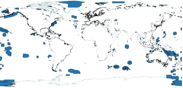
Even though only a small fraction of the ocean is protected, a considerable progress has been made in the last decade. Lubchenco and Grorud-Colvert (2015) reported 3.5% of the ocean being protected, while the current assessment by the United Nations Environment World Conservation Monitoring Centre (UNEP-WCMC) with support from IUCN and its World Commission on Protected Areas (WCPA) refers that 6.97% of the global seas are protected (Fig.1.1). This rise is expected to continue in the next years, with the emerging trend for establishing and implementing remote large-scale marine protected areas within and beyond national jurisdiction (Leenhardt et al. 2015). Marae Moana Marine Park in the Cook Islands designated in 2017 became the largest multi-use marine park in the world, covering an area of of nearly two million square kilometres.
While the broad objective of the initial movement for protected areas was to conserve iconic and vulnerable seascapes and species, their purpose has changed over the past century towards the emergence of a much more systematic and ecosystem-based approach. A shift in protected areas philosophy promotes the protection of the structures and functions of marine systems, the provision of crucial ecosystem services (food security, human health, carbon storage), contribution to national and local economies (replenish fisheries, tourism revenues), and expects them to play a key part in the resilience and mitigation of climate change (Watson et al. 2014, Gormley et al. 2015).
Chapter I
13
Figure 1.1 Map showing current worldwide MPAs (blue polygons and dark coastal contour). This database is updated monthly and managed by the United Nations Environment World Conservation Monitoring Centre (UNEP-WCMC) with support from IUCN and its World Commission on Protected Areas (WCPA). At present, the database reports 15 609 designated, inscribed, and/or established MPAs, includes 25,245,207 km² of marine areas and covers 6.97% of the total ocean (https://protectedplanet.net/marine).
In general, MPAs’ benefits and/or challenges largely depend on MPA purpose, location, design, management approaches and level of protection, funding and restrictions on human uses. Currently, MPAs should no longer be established on an individual ad hoc basis, but scale up to a network approach, considering the protection of the structures and functions of marine systems, in an integrative manner.
1.2 From individual MPAs to Networks of MPAs
At an international level, the fact that MPAs should work in synergy with each other has been comprehensively outlined by the International Convention on Biological Diversity Aichi Biodiversity Target 11 (CBD 2010). This target for marine conservation, signed by over 150 government leaders, states that “by 2020 at least 10% of coastal and marine areas, especially areas of particular importance for biodiversity and ecosystem services, would be
conserved through effectively and equitably managed, ecologically representative and well-connected systems of protected areas and other effective area-based conservation measures that are integrated into the wider seascapes.” This way, simply reaching large percentage area
Chapter I
14
coverage of MPAs is not sufficient to meet the requirement of ‘ecologically representative and well-connected systems’ defined by the CBD.
A more ambitious goal was set by the IUCN World Parks Congress 2014 in Sydney, with a recommendation to “urgently increase the ocean area that is effectively and equitably
managed in ecologically representative and well-connected systems of MPAs or other effective conservation measures. This network should target protection of both biodiversity and ecosystem services and should include at least 30% of each marine habitat. The ultimate aim is to create a fully sustainable ocean, at least 30% of which has no extractive activities."
The term ‘network of MPAs’ is therefore frequently used in environmental policies and guidelines, but it is still poorly defined. In this sense, it is important to distinguish a network of MPAs from a set of MPAs (Roff 2005). While a set of MPAs is any group of protected areas within a defined geographic region, a network of MPAs is a “a collection of individual MPAs operating cooperatively and synergistically, at various spatial scales, and with a range of protection levels designed to meet objectives that a single reserve cannot achieve” (IUCN-WCPA 2008). It is then expected that the network increases the ecological, social and economic benefits when compared to the individual performance of its constituent MPAs. Planning for the networks requires careful considerations of their purpose for implementation, design, size, spacing and level of protection of the individual MPAs. Several studies have already highlighted the ecological benefits of networks of MPAs (Sala et al. 2002, Planes et al. 2009, Christie et al. 2010, Grorud-Colvert et al. 2014).
In European waters, MPA networks have largely been driven by the European Union (EU) Natura 2000 network, an important environmental pillar of the wider EU Integrated Maritime Policy. This ongoing process aims to develop a coherent network of special areas of
conservation to protect threatened species and vulnerable habitats. The marine area included
in the network doubled in the last five years and is currently comprised of more than 3140 marine sites, covering around 7% of EU seas (Natura barometer October 2017).
Additionally, the Marine Strategy Framework Directive (MSFD) stipulates that Member States need to include into their programmes “spatial protection measures, contributing to
coherent and representative networks of MPAs”, so as to support a Good Environmental Status
(GES) in the marine environment by 2020. Moreover, the European Regional Seas Committees (RSC) promotes the establishment of a coherent network of MPAs to ensure the sustainable use, protection and conservation of marine biological diversity and its ecosystems (e.g. OSPAR 2007, HELCOM 2010).
Chapter I
15 At the national level, the Portuguese government recently adopted the National Strategy for the Seas (ENM 2013-2020) (Resolution of the Council of Ministers No. 12/2014 of 12 February. D.R. No. 30, Series I). It promotes “the establishment of a network of marine
protected areas, efficiently managed, coherent and adapted to the territory within the framework of the international commitments and the national strategy for nature conservation, in order to recover degraded ecosystems and promote its potential as a recruitment area, thus contributing to improve the efficiency of activities, in particular fisheries”. Importantly, it also refers that the “the delimitation of new marine protected areas, as well as the implementation of management plans, requires the scientific recognition of the natural values and its impacts and pressures, thus contributing to consolidate the process of the Natura 2000 network to the marine environment.”
In mainland Portugal, which is the focus of this thesis, the establishment and management of protected areas (at national and regional level) is a competency of the Institute for Nature Conservation and Forests (ICNF) in articulation with the Directorate-General of Natural Resources, Security and Maritime Services. The designation of areas classified under the Natura 2000 network, RAMSAR Convention, European Network of Biogenetic Reserves (Council of Europe) and the Biosphere Reserves (Man and Biosphere - UNESCO) – are also a responsibility of ICNF. There are different types of protected areas with different management objectives and regimes according to the protection category: natural monuments, natural reserves, natural parks, national parks, protected landscapes, classified sites, private protected areas and “marine parks or “marine reserves”.
Six national protected areas in mainland Portugal include a maritime area, hereafter called national marine protected areas. They cover an area of 535.71 km2, representing 0.16% of the Portuguese EEZ (of mainland territory), with a combined no-take area barely covering 5 km2 (0.0015% of the EEZ). Their sizes range from 2.6 km2 to 290 km2, and are separated from each other by an average distance of 80 km (Abecasis et al. 2017). Regarding the Natura 2000 network, Portugal has already designated 7 marine Special Protection Areas (SPAs) under the Birds Directive, covering an area of 6366 km². As for the Habitats Directive (Sites of Community Importance, SCIs) Portugal designated 6 sites, covering an area of 23340 km² (Banco Gorring SCI alone covers an area of 22887.8 km²). There is also a formalized national proposal for the creation (or expansion) of 3 additional marine SCIs, awaitting approval by competent national authorities. While SPAs are designated directly by Member States, SCIs are first proposed by Member States and, when approved by the European Commission, are designated as Special Areas of Conservation (SACs). Portuguese MPAs, designated Natura 2000
Chapter I
16
SPAs and SCIs and currently proposed SCIs in continental Portuguese shelf waters, are mapped in Fig. 1.2, 1.3 and described in table 1.2.
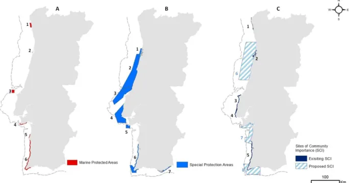
Figure 1.2 A - Current Portuguese MPAs B – Natura 2000 Special Protection Areas (SPAs) C - Existing and proposed Natura 2000 Sites of Community Importance (SCI). Banco Gorringe SCI is showed in figure 1.3. Dashed lines represent 200 m depth contours. Numbers in the maps are described in Table 1.2.
Chapter I
17 Table 1.2 Current Portuguese MPAs, Natura 2000 SPAs and SCIs (and proposed SCIs). Numbers represent areas in figures 1.2 and 1.3 and areas in brackets represent no-take areas.
*The total area of Portuguese continental Exclusive Economic Zone (EEZ) is 327,667 Km².
**According to the IUCN categorization of protected areas, Category IV (Habitat/Species Management) - protected areas aimed to protect particular species or habitats and management should reflect this priority. Category V (Protected Landscape/Seascape) - A protected area where the interaction of people and nature over time has produced an area of distinct character with significant, ecological, biological, cultural and scenic value: and where safeguarding the integrity of this interaction is vital to protecting and sustaining the area and its associated nature conservation and other values.
Networks of MPAs should operate cooperatively and synergistically to meet objectives that a single reserve cannot complete. In Europe, the process of creating networks of MPAs have been largely motivated by the CBD international target for marine protection, and driven by the Natura 2000 process, by Regional Seas Conventions, and backed up by national legislations.
Classification Nº Designation Area (km²)
Creation (reclassificat ion) Managem ent Plan (IUCN) category) General objectives Pa rk 1 Litoral Norte 74.5 1987 (2005) 2008 (V)
Res erve 2 Dunas de Sao Jacinto 2.6 1979 (2004) 2005 (IV)
Pa rk 3 Berlengas 94.4 1981 (1999) 2008 (IV)
Pa rk 4 Arrábida 52.71 (4.32) 1971 (1976) 1980 (V)
Res erve 5 Lagoas de Santo André Sancha 21.4 2000 2007 (IV) Res erve 6 Sudoeste Alentejano e C. Vicentina 290 (0.63) 1988 (1995) 1995 (V)
1 Ria de Aveiro 264.0 1999 2 Aveiro/Nazaré 2929.3 2015 3 Ilhas Berlengas 1026.6 1999 4 Cabo Raso 1335.0 2015 5 Cabo Espichel 155.8 1999 6 Costa Sudoeste 552.3 1999 7 Ria Formosa 103.3 1999 1 Litoral Norte 17.93 2004 2 Ria de Aveiro 80.8 1999 3 Peniche/Santa Cruz 57.99 2000 4 Sintra/Cascais 93.13 1997 5 Costa Sudoeste 202.5 1997
6 Ba nco Gorri nge 22887.82 2015
6 Maceda/Praia da Vieira 5026
7 Costa de Setúbal 1233
8 Costa Sudoeste 1632
Total a rea des i gna ted 30242 (4.95) % of ma i nl a nd EEZ protected 9.22% (0.0015%) Adi tiona l a rea propos ed 7891.0 TOTAL Na tiona l MPAs Si tes of Communi ty i mportance (SCI) Propos ed expa ns i on or crea tion of SCIs Na tura 2000 Speci a l Protection Area s (SPA) Ha bi tats , s peci es a nd cul tura l va l ue cons erva tion Sus tai na bl e ma na gement of economi c a ctivi ties a nd a rtis a na l fi s heri es Ma i ntena nce/res tora ti on of cons erva tion s tatus of bi rds s peci es l i s ted i n Annex A-I to Decree-La w No 140/99, a nd thei r ha bi tats ; a nd mi gra tory s peci es wi th regul a r occurrence i n the na tiona l terri tory. Contri bute to bi odi vers i ty protection through the
cons erva tion of threa tened na tura l ha bi tats a nd s peci es l i s ted i n theHa bi tats Di rective nº 92/43/CEE
under discussion
Chapter I
18
1.3 The concept of ecological coherence for networks of MPAs
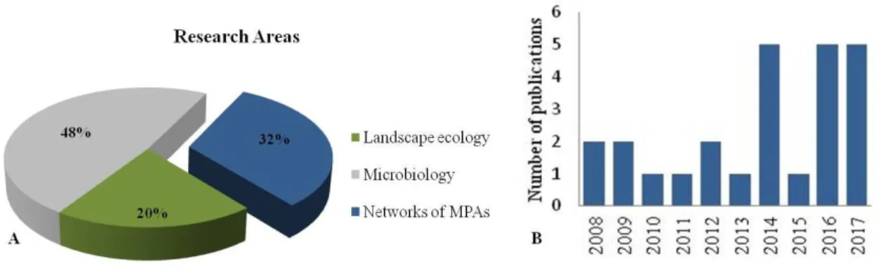
In environmental policies, the notion of networks of MPAs is usually associated with the concept of ecological coherence, whose definition is still vague and arbitrary. The term ‘ecological coherence’ lacks a theoretical foundation in ecological conservation science, and therefore, is difficult to implement (Jones and Carpenter 2009). Nonetheless, ‘ecological coherence’ appears in several key European environmental policy legal documents (reviewed in Catchpole 2013), but is rarely employed in peer reviewed environmental publications. Results from a search on ISI Web of Knowledge for the words ‘‘ecological coherence’’ or ‘‘ecologically coherent” appearing in the title or abstract fields resulted in 80 publications, with only 25 studies referring networks of MPAs (Fig. 1.4A).
From the analysis, 20% of the studies on ISI Web of Knowledge fit in the terrestrial ecology field and habitat restoration and almost half of the studies belonged to microbiology research field (48%), mostly concerning bacterial communities (where “ecological coherence of a taxon” means sharing general life strategies or traits that distinguish them from members of other taxa). Interestingly, the first peer reviewed study relating ecological coherence and networks of MPAs came out in 2008 (Fig. 1.4B), almost 16 years after the Habitats Directive (Council Directive 92/43/EEC, Article 3) mention the need of “a coherent European ecological network”, and five years after the ministerial commitment to achieve ecological coherence within the OSPAR and HELCOM networks of MPAs (JMM 2003).
Figure 1.4 A - Results from a search on ISI Web of Knowledge for the words ‘‘ecological coherent’’ or ‘‘ecologically coherent” appearing in the title or abstract fields, separated by research areas. B - Results concerning the search described for the networks of MPAs category. The number of published articles per year is plotted. The graph starts with the first hit.
Chapter I
19 In Europe, the concept of ecological coherence is mostly linked with the Natura 2000 and regional seas conventions. In the Natura 2000 Habitats Directive (Council Directive 92/43/EEC), the term “ecological coherence” was made in the preamble to the Habitats Directive Article 3.1: “A coherent European ecological network of special areas of conservation shall be set up under the title Natura 2000”. In the context of the Natura Directive an ecologically coherent network should:
i. represent the full range of variation in valued features; ii. replicate specific features at over a wide geographic area;
iii. allow for dispersal, migration and genetic exchange of individuals between relevant sites, and include all critical areas for rare, highly threatened and endemic species; iv. be resilient to disturbance or damage caused by natural and anthropogenic factors.
A more comprehensive policy-based definition of ecological coherence comes from the OSPAR Convention (Ardron 2008), where an ecologically coherent network of MPAs:
i. interacts with and supports the wider environment;
ii. maintains the processes, functions and structures of the intended protected features across their natural range;
iii. functions synergistically as a whole, such that the individual protected sites benefit from each other in order to achieve the other two objectives;
iv. should be designed to be resilient to changing conditions.
In general, these concepts for ecological coherence are built upon many branches of ecological theories and supported by evidence-based research on: community ecology (e.g. Koelle and Vandermeer 2004, Leibold et al. 2004), ecological health (e.g. Lu and Li 2003), ecosystem integrity (e.g. De Leo and Levin 1997) and ecological resilience (e.g. Holling, 1996, Peterson 2000, Mumby et al. 2014, Scheffer et al. 2015). An integrated and consensual theory of “ecological coherence” is however, still missing.
The concept of ecological coherent in regards to networks of MPAs seems to be much more policy-driven rather than scientifically grounded. Coherent networks should deliver added ecological, economic, and social benefits through complementary outcomes of individual MPAs in fisheries management (Gell and Roberts 2003), biodiversity conservation (Almany et al. 2009) and climate change adaptation and recovery after disturbance (Foley et al. 2010).
Chapter I
20
1.4 Criteria used to assess the degree of ecological coherence of networks of MPAs
In order to be efficient, networks of MPAs depend mostly on its configuration (size, shape, spacing, and location) and management. It is then necessary to find clear and measurable objectives to establish ecologically coherent networks of MPAs and demonstrate the ‘added-value’ of MPAs networks in relation to individual ones (Grorud-Colvert et al. 2014). For the purpose of this study, and in order to avoid multiple definitions and concepts, I have focused on four main criteria used to assess ecological coherence of networks of MPAs, recognized by the Convention on Biological Diversity (CBD 2008), the regional sea conventions (OSPAR 2007, HELCOM 2010) and recommended by an independent study requested by the EU Directorate-General for the Environment (Wolters et al. 2015): representativity, replication, adequacy and connectivity.
The international guidance reports concerning network coherence show that there is a general concordance in these four criteria employed for the European marine regions (Fig. 1.5) However, there are other relevant and comparable criteria cited in the literature. For example Catchpole (2013) underlined the importance of viability and resilience criteria; Lawton et al. (2010) gave more emphasis on anthropogenic factors, such as human accessibility and management and for Connor et al. (2002), representativity is called ‘typicalness’. Moreover, CBD (2008) considered “Ecologically or biologically significant areas” as places providing important services to one or more species/ populations of an ecosystem or to the ecosystem as a whole, compared to other surrounding areas.
1.4.1 Representativity
As species diversity increases with habitat diversity, MPAs that include a variety of habitats and community types within well-connected networks, contribute to the persistence and resilience of ecosystems and ecological processes (Roberts et al. 2003). In this sense, scale is a key criterion to assess representative. While at a broader regional level, assessments can be made at a biogeographic regional scale defined by temperature and depth or major geomorphology (OSPAR 2013), at smaller scales, other units may constitute more ecologically meaningful surrogates for representation. Examples include the use of marine landscapes (Golding et al. 2004), individual habitat types and species, such as rare habitats (Roberts et al. 2003) and areas of critical importance for different life stages of species (Roberts and Sargant 2008). However, the smaller the scale, the more refined and in-depth knowledge is required on the overall distributions of habitats and species.