Resumo: O vale do Tua, no norte de Portugal, está neste momento a passar por uma intensa transformação com a conclusão da construção da barragem de Foz-Tua. Como consequência, parte do vale e da centenária linha do Tua serão submergidos. Contudo, as ramificações completas deste empreendimento ainda não são conhecidas. Neste artigo não iremos fazer julgamentos sobre a barragem ou o encerramento da linha. Preten-demos sim apresentar as transformações tecnológicas do vale do Tua e interpretar esta região como paisa-gem simbólica e tecnológica, contribuindo para o debate sobre a compreensão da paisapaisa-gem e sobre a proble-matização das fronteiras entre tecnologia e paisagem, muitas vezes consideradas realidades inconciliáveis. Palavras-chave: Paisagem Tecnológica; Paisagem Simbólica; Vale do Tua; Linha do Tua; Barragem de Foz-Tua.
Abstract: The Tua Valley, in northern Portugal, is undergoing an intense transformation with the conclusion of the construction of the Foz-Tua dam. As a consequence, part of the valley and part of the centennial Tua railway will be flooded by the dam’s lake. However the complete consequences of this undertaking are yet to be fully known and understood. In this paper we do not aim to judge the decision to build the dam or to close the railway line. Our goal is to display the technological evolution of the Tua Valley and question the interpre-tation of this region as both symbolic and technological landscape. We wish to contribute to the debate about understanding landscape, and discuss the frontier between technology and landscape, two realities that are often seen as incompatible and disagreeing.
Keywords: Technological Landscape; Symbolical Landscape; Tua Valley; Tua Railway; Foz-Tua Dam.
THE TUA VALLEY IN
TRANSITION, SYMBOL
AND TECHNOLOGICAL
LANDSCAPE
ELLAN FEI SPERO* HUGO SILVEIRA PEREIRA**
INTRODUCTION
The Tua Valley, in northern Portugal, is going through a dramatic transformation with the construction of the Foz-Tua dam currently underway. As we write in May 2016, this work already is nearing completion. The reservoir will soon begin to fill and energy production is planned for early 2017, according to the dam’s operator, Energias de Portu-gal (EDP)1.
* Massachusetts Institute of Technology. Singapore University of Technology and Design. [email protected].
** CIUHCT – Interuniversity Center for the History of Science and Technology (Faculty of Science and Technology – Univer-sidade NOVA de Lisboa). Institute of Railway Studies (University of York). [email protected]. Financed by National Funds Post-doctoral fellow ref. SFRH/BPD/95212/2013.
1 Ecologistas pedem intervenção da UNESCO para impedir barragem do Tua. «Económico», 22/05/2016. Available in <economico. sapo.pt/noticias/ecologistas-pedem-intervencao-da-unesco-para-impedir-barragem-do-tua_250015.html>. [Visited on 25/05/2015].
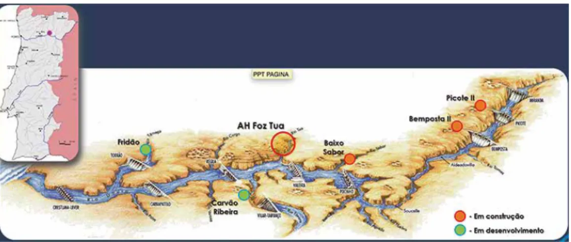
Figure 1 – Location of Foz-Tua dam.
Source: COSTA, 2011.
The impact of this construction project, partially situated in a UNESCO World Heritage area, will undoubtedly be considerable, however the complete ramifications are yet to be fully understood. This paper emerges from a three-year project (2011-2013) that brought together historians, engineers, and designers from Portugal, Europe and North America to study the history and interpretation of the Tua railway line and its Valley, which would be flooded in the dam construction process. This collaborative and cross-disciplinary project itself is well suited to this special issue themed around border crossing and connecting edges. Facing the impending changes to the Tua Valley with the introduction of a large technical system, the dam, this group convened to contextualize the construction of yet another – the narrow gauge rail line, which would soon be submerged2. This group focused on the history of narrow gauge mountain tracks: the decision-making processes that brought them into being, their technical features and challenges, their past and present social, economic, geographical and geological contexts, their operation, subsequent closures, and also possible reuse and transformation into new forms as heritage rail and other forms of recreational transport3. In some respect, it was a historical project seeking to shock the new, with the old, to borrow a few words from historian of technology, David Edgerton4. As scholars and practitioners working together, our role was to gather and analyze while also seeking to preserve and foster discussion about the cultural value of both the industrial and natural heritage of the valley and its railway. This paper follows in that spirit. It is not our intention to pass judgment on the dam construction, or the fate of the railway line. It also not our intent to determine the impact the dam will have on the valley’s landscape or whether it will have consequences on the Douro Valley’s UNESCO classification as World Heritage site.
2 For more on large technical systems see HUGHES, 1983 and VLEUTEN, 2006.
3 McCANTS et al., 2016.
Rather, we aim to present the technological transformation of the Tua Valley, and offer this case as a site to interrogate the interpretation of this region as symbolic and techno-logical landscape5. Through this example, we wish to contribute to the ongoing conver-sation about the metaphors we use to understand landscape, and problematize the boundaries so often drawn between technology and landscape, as two irreconcilable and conflicting realities6. In closing, we will offer a comparative case of controversial lands-cape change with another large technical system, the Eurotunnel constructed in the 1990s in Kent, United Kingdom7.
THE FOZ-TUA DAM CONSTRUCTION PROJECT,
AND A CLASH OF SYMBOLS
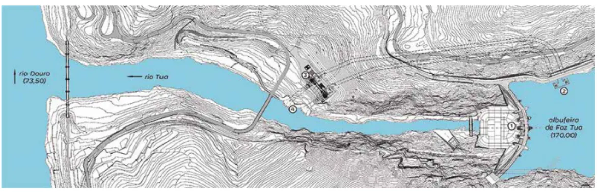
In addition to the dam, itself over 100m in height, with a maximum threshold of 170m above the sea level, a power station was also constructed. This structure, designed by the Pritzker Award-winning architect Souto Moura, was meant to be partially obscured by a bunker beneath the cliffs that surround the river8. When the reservoir is complete, part of the river’s shores and forest will be submerged, along with part of the metaphor-laden Tua railway9. While the full implications are still yet to be realized, this plan presented a smaller scale intervention than earlier proposed scenarios. Two other proposals were considered with higher walls, which would create a larger reservoir (maximum elevation of 180 m and 195 m, respectively) that would have submerged a wider area of the valley and a larger extension of the railway10.
Figure 2 – Schematics of the dam and power station.
Source: EDP.
5 ROLLINS, 1995: 496. MACEDO, 2009. SPERO, 2013.
6 NYE, 1999. See LATOUR, 2004: 57-62 for a similar analysis of the «disastrous opposition» between human beings and their environment.
7 DARIAN-SMITH, 1999.
8 ALVES, 2012.
9 EDP, 2016. PINTO, 2016.
Unsurprisingly, the decision to build the dam created a considerable controversy within Portuguese publics. In fact even the overall plan in which the Foz-Tua dam was envisaged (National Program for Dams of High Hydro-electrical Potential/Programa Nacional de Barragens de Elevado Potencial Hidroelétrico), approved in 200711, was recei-ved with skepticism, to say the least. Its elaboration was considered hasty and based upon outdated information, even though it might be an in important step for the future deve-lopment of hydro-electrical production12.
However, even so-called clean energy production infrastructures are being contested for their impact on landscape (in addition, for the Foz-Tua case there were also doubts about the added energetic value of the dam). Indeed according to research by Delicado et al. on community perception of energy technologies, «there is a widespread opinion that renewable energy generation technologies (…) stand in conflict with landscape preserva-tion and values.». They are thus perceived as «threats to collective identity, emopreserva-tional connections to a particular location or scenic feature»13. This is particularly evident in the case of wind and solar farms14.
In addition to these issues about the construction of renewable energy systems, the Foz-Tua dam project would also bring with it the closure of the Tua line, the last Portu-guese mountain narrow gauge track still in operation. However, in 2006 the PortuPortu-guese Railway Company (CP) had already anticipated the termination of this line15. The line between Foz-Tua and Mirandela was indeed closed in 2008 (the track between Mirandela and Bragança had been shut down 17 years before), after a few accidents with its LRVs (light rail vehicles) that secured passengers traffic between Mirandela and Foz-Tua. The decision to close the track also met with controversy. After all, the Tua line was a centen-nial railroad, inaugurated from Tua to Mirandela in 1887 (and to Bragança in 1906)16, and with this status came a very high-perceived value as cultural heritage. In addition, some sectors of Portuguese society and politics correlated the recent accidents on the Tua line with the decision to build the dam17.
Furthermore, despite cultivation of viticulture in this region, it was also publically argued that the Tua Valley was almost a wild region, in a natural and rough state. Indeed, as recent as the 1970s, well after the growth of the wine industry and railway in this region, the Portuguese writer Miguel Torga described the Tua Valley as a «virginal universe»18. However, since electricity was only slowly introduced in this region during the 1960s19, a 11 GOMES, 2016.
12 FÉLIX, 2010: 101-102.
13 DELICADO et al., 2016: 85-86.
14 DELICADO et al., 2016: 91.
15 AZEVEDO & SALGUEIRO, 2015: 472. CP quer liderar ferrovia na Península Ibérica em 2010. «Diário de Notícias», 27/03/2006. Available in <www.dn.pt/arquivo/2006/interior/cp-quer-liderar-ferrovia-na-peninsula-iberica-em-2010-638134.html>. [Visited on 26/05/2015].
16 ALEGRIA, 1990.
17 Linha do Tua: os acidentes e a barragem. «Esquerda.net», 27/12/2008. Available in <www.esquerda.net/dossier/linha-do--tua-os-acidentes-e-barragem>. [Visited on 26/05/2015].
18 Apud LAGE & BEIRA, 2013: 2.
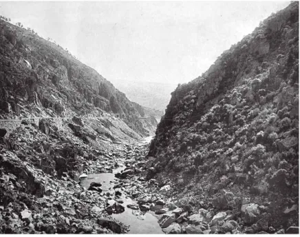
process that Torga could have witnessed firsthand, his characterization of a remote and wild place is not entirely unfounded. Unsurprisingly, nearly a century earlier, during the inauguration of the railway line in September 1887, descriptions of the valley in the popular press, Diario de Noticias, shared a similar sentiment. The reporter highlighted the impressive scenery of the Tua Valley – that surely had posed major difficulties to the builders of the line – but in particular he emphasized the right margin of the river, with its ravines, narrow passes, and huge and smooth granite rocks as evidence that humans had never set foot in such areas20. Pictures taken at the time of the inauguration of the railway in 1887 by Karl Emil Biel (figures 3 and 4) and even contemporary panoramic images (figure 5) that highlight the ruggedness of the landscape might also be interpreted to reaffirm the enduring (or even perceived timeless) wildness of the valley.
This notion of wilderness also serves as a powerful metaphor for what it means to be an inhabitant of these regions – a transmontano, a tough, fearless, survivor in a harsh land21. It was argued that the building of the dam would present serious damage to this spirit. In this process place attachment, an emotional and affective connection between an individual or a collectivity and a given area, also plays an important role; and it may account for the conflict towards technologies that will change «sites or spatial elements included in the affections and in both individual and collective memory»22,23. For the transmontano, or at least characterization of this group of people, the landscape may be considered not only a home but a social space, an expression of ideology, and more importantly one that is capable of defining a collective imagination24. Hence, the analysis of how the local populations perceive the new technological system will also be taken into consideration in this paper25.
The debate surrounding the dam decision-making process and the actual commence-ment of works in February 2011 only served to enhance the strength of the representation of the Tua Valley as an untouched wilderness26. The authenticity of this powerful symbol of untouched nature was placed into jeopardy with the construction of the dam, described as a monster by some popular press27,28. A 2016 news article in the Portuguese news magazine Visão also highlighted the condition of raw nature of the valley29. The reinforcement of this representation of the Tua Valley as a particularly untainted place in the popular imagination is by no means unique. Indeed, it is consistent with philosopher of science and technology, Bruno Latour’s argument that «nature is a historically situated social representation», a
20 Apud MARTINS et al., 2015: 97.
21 LAGE, 2015: 376. For the connection between landscape, territory, place and identity see CAROLINO & PINTO-CORREIA, 2011: 91-92 and 110-112.
22 DEVINE-WRIGHT & HOWES, 2010.
23 DELICADO et al., 2016: 89 and 91.
24 DARIAN-SMITH, 1999: 21.
25 ESCOBAR GÓMEZ, 1995: 834.
26 Barragem do Tua representa investimento de 305 milhões de euros. «Público», 18/02/2011. Available in <www.publico.pt/ economia/noticia/barragem-do-tua-representa-investimento-de-305-milhoes-de-euros-1480988>. [Visited on 26/05/2015].
27 For a discussion of representation and its influence on reality see MOSCOVICI, 2005.
28 PARAFITA, 2016.
social and cultural construction30. This often occurs when the observer travels away from regions were technology is more present and widespread. Literary scholar, Neil Rennie, describes this sort of travel as regressive. Here, the traveler encounters, «not a new land so much as a new location for old, nostalgic fictions about places lost in the distant past». These so-called nostalgic fictions are «now found on the distant present, found and confir-med, it seeconfir-med, in the form of exotic facts»31. This exoticism and rediscovery of the wilder-ness, especially in comparison to the more familiar Portuguese urban centers such as Lisbon or nearby Porto, was reflected in the romantic symbolism of the Tua Valley in the popular imagination. Although representations may be deformed perceptions of a particu-lar reality, they can also take the place of that reality. Indeed, they are often more seductive than the real from which they were inspired32. Bruno Latour also identified this phenome-non while describing how westerners perceived phenome-non-Western peoples as living integrated with nature, while in fact there were multiple examples of «massive disharmony»33. Perhaps in the case of the Tua Valley landscape it is more romantic to understand this place as a natural region rather than a place fraught with all kinds of technological traces – the agri-cultural terraces, bridges, dykes, and in particular the decaying railway, especially in the face of yet another large and very controversial technological system.
30 LATOUR, 2004: 232 and 33-35.
31 RENNIE, 1995.
32 FERNANDES, 1998.
33 LATOUR, 2004: 44.
Source: BEIRA, 2014: 14.
Figure 4 – Another aspect of the Tua Valley by Karl Emil Biel, 1887.
Source: BEIRA, 2014: 20.
Figure 5 – Panoramic shot of the Tua Valley, as photographed by Nuno Beira 2015.
THE TUA VALLEY, A TECHNOLOGICAL LANDSCAPE
The characterization of an untouched wilderness facing a hulking technological menace is of course a powerful image that resonates far beyond this small region in Portugal, or for that matter this particular fragment of time. However, it also obscures a more nuan-ced human history of the valley, its inhabitants and their technological systems including agriculture and railway systems. It is this need to reconcile a longer history of human intervention within a changing landscape that urges us to find other tools for thinking about the valley more inclusively. With its stunning ridges and slopes, its climate, its terraces for vineyards, its railways, old donkey roads, new motorways, bridges, and the recent addition of the dam, the Tua Valley provides a useful and striking context to reflect upon ever-shifting concepts of technological progress, center and periphery, connectivity, what constitutes traditional or high-tech agricultural practices, and the complexity of the preserving and interpreting the past. To aid in this thought experiment, we turn to the concept of technological landscape as a process of change.
First, let us return to the notion of landscape itself. In J. B. Jackson’s Discovering the Vernacular Landscape (1984), landscape is «a composition of man-made or man-modi-fied spaces to serve as infrastructure or background for our collective existence»34. Histo-rian of technology, David Nye builds upon Jackson’s interpretation and highlights the concept of landscape «not as natural, but cultural». Within this framing, «it is not static, but part of an evolving set of relationships». Nye characterizes landscape as, «part of the infrastructure of existence (…) inseparable from the technologies that people have used to shape land and their vision»35. Hence, for Jackson and Nye technologies and landscape are not opposites, but rather subtly interwoven items. Nye emphasizes the role of lands-cape as «a process embedded in narrative, or time,» not only an object but also an action36. Literary scholar and art historian, W. J. T. Mitchell also highlights the dynamic aspect of landscape «not as an object to be seen or a text to be read, but as a process by which social and subjective identities are formed»37.
Building on Nye’s technologies of landscape, we use the related, yet distinct concept, technological landscape38. Our use of this term is meant to encompass both the human and non-human actors of the valley together in a socialized relationship under Latour’s methodological umbrella of the actor-network theory39; or within the Territorial Analysis theoretical paradigm that takes into consideration a structured array of different elements (physical, demographic, infrastructural, anthropological, cultural) in a determined
Terri-34 JACKSON, 1984.
35 NYE, 1999: 3.
36 NYE, 1999: 5-7.
37 MITCHELL, 2002: 1.
38 MACEDO, 2009. SPERO, 2013.
39 For more discussion of actor-networks, non-human actors, the relevance of the seamless and interweaving relationships between human and non-human actors, and the need to socialize non-humans see: CALLON, 1986/1998, CALLON & LATOUR, 1992, LATOUR, 2004: 49-90, and PICKERING, 1993.
torial System, which is also influenced by its historical evolution and other external elements40.
In the case of the Tua Valley, we not only include the wild or natural features such as the ridges, the cliffs, and the river, but also railway, bridges, dykes, viaducts, agricultu-ral structures, the dam under construction, and of course human and non-human beings into and integrated whole. Here, it is our intention to privilege neither the people, nor land, nor technologies in this discussion, but rather to blur the boundaries between them and treat these actors as parts of a dynamic and interconnected system. Yet, while this interconnected, or going one step farther, co-produced approach is certainly not new to scholars of science and technology, this more unified concept is still yet to take hold in the more popular understanding of science, technology and environment41.
If we observe the valley and its history outside of the binary assumption of nature and artifice – what else might we see? Let us return to the photographs taken by Biel in 1887. Indeed, when Biel’s photographs are viewed together as a more complete collection portraying the region at the end of the 19th century, another view of the landscape comes
into focus. This focus on photography as a tool for preservation and communication about the landscape also helps us interrogate this representation of the wild. It by no means diminishes the authenticity of the image of wilderness – rather it places it into context. Just as the words and sentiments employed in popular writing focused on one particular aspect of the valley, the camera and photographer also explicitly decided what would be captured within the frame and what should remain outside the scope of the composition.
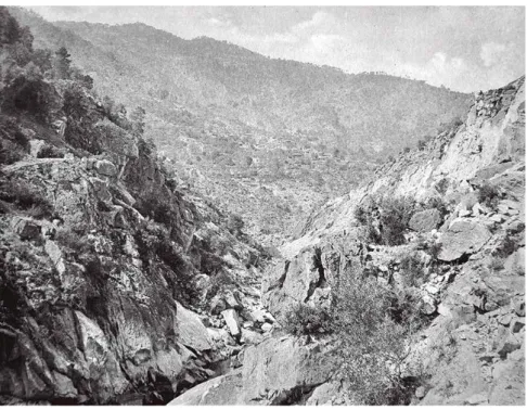
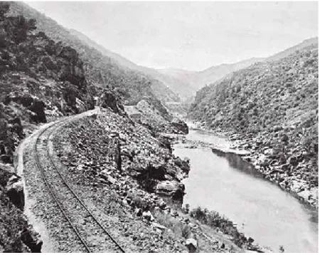
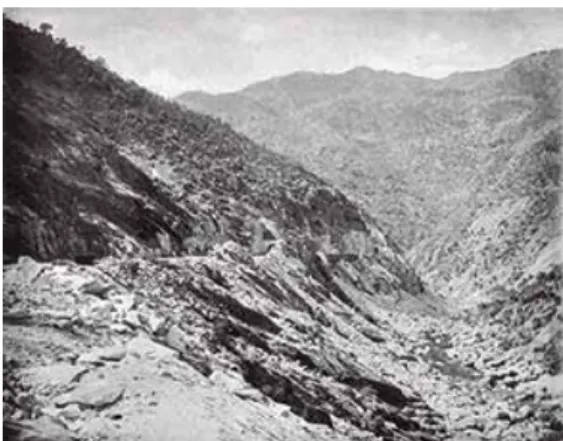
In Biel’s photographs of the newly laid track in 1887, evidence of the construction process is also apparent. The tunnels, viaducts, and the road itself required the use of dynamite to blast away a path in the valley’s cliffs. The construction of the supporting walls for the first 21 km of track alone required 170,000 m3 of rock. For example, in Figure 6, we can see not only the railroad and its bed, but also the rubble that was drilled from the ridges and discarded into the valley’s slopes, along with a small dyke across the river. Figure 8 depicts yet another aspect of the impact of the drilling to make way for the railroad. Figure 7 portrays the Fragas Más complex including two tunnels and a viaduct between them. In this image there is also a considerable deposit of broken rock in the river. Finally, in Figure 9 we can compare the differences between the opposite sides of the valley: the left bank with the railway and the trundled rocks above the river slopes; and the right bank with its intact rocks and bushes.
40 ESCOBAR, 1995: 832.
Built between 1884 and 1887, this section of the railway leading to Mirandela inclu-ded five tunnels, two viaducts and 118 supporting walls adjacent to the first 21 km of track along the narrowest part of the valley. Due to the challenging engineering circums-tances, the Tua line became a working monument to Portuguese ingenuity42. Not only a method of transport, and symbol for national engineering achievement, the railroad was also symbol for the arrival of progress for one of the most underdeveloped provinces of Portugal43. In addition, the opening of the line brought yet another element to this valley now lined with tracks – the trains themselves. Beginning with different steam locomoti-ves that operated until the 1970s along with the more recent additions of Dutch and Yugoslavian railcars and diesel engines, the apparent stillness of the Tua Valley was often punctuated by the roar of the locomotives engines and whistles and the rattling and clanking of the assorted wagons and carriages44.
42 MARTINS et al., 2015: 96.
43 LAGE, 2015: 373.
44 PEREIRA, 2016.
Source: BEIRA, 2014: 18.
Figure 7 – The Tua line in Fragas Más, as photographed by Karl Emil Biel, 1887.
Source: BEIRA, 2014: 17.
Figure 8 – The São Lourenço station, as photographed by Karl Emil Biel, 1887.
Source: BEIRA, 2014: 23.
Figure 9 – A curve in the Tua line just outside São Lourenço station,
as photographed by Karl Emil Biel, 1887.
While the transformation of the valley with the railway construction might be the most comprehensively planned and dramatic over such a short time frame, other signifi-cant land shaping practices included agricultural systems, roads of various scales, bridges and dykes. Already by 1910 almost half of the Tua river basin area was being used for agricultural purposes. Uncultivated lands accounted for 38% of the total area whereas the remainder was occupied by forest. It is important to note that, «the distribution of the uncultivated areas is consistent with the areas of steep slopes and hilltops [the valley itself], but not exclusive»45. As a matter of fact terraces (socalcos) may be found wides-pread in the lower Tua Valley, specifically for the cultivation of vineyards and olive groves46. Throughout the remainder of the 20th century, the occupation of the territory proceeded at different rates, varying along with the socio-economic dynamics of the region. In 1990 we note a huge decrease in uncultivated areas (from 22% to just below 2%), and a high increase in the forest area that covered almost 54% of the total area. Cultivated areas also witnessed a slight decrease, as the forest reclaimed many previously cultivated areas. This trend of reforestation, mainly due to demographic factors like emigration and the aging of the population, continued into the beginning of the twenty--first century47.
Several bridges spanning the valley demonstrate a long history of construction in the region. The first bridge was the so-called Ponte do Diabo (The Devil’s Bridge) connec-ting the two banks of the Tua near Abreiro. Although a precise date of construction is yet unknown, it was thought to be several hundred years old by the time it washed away in a flood in 1909. A modern cement bridge replaced this structure in the early 1940s. At the same time another similar bridge was also constructed near the mouth of the Tua River not far from the older railway bridge of the Douro line, inaugurated in 1883. More recently, new roads were also added, two near Brunheda, and two others in the vicinities of Vilarinho das Azenhas and Frechas.
Other man-made structures also changed the face of the Tua Valley and River, like for instance small weirs and dykes built along the river and even a small cable car in Amieiro in the right bank of the Tua that made the connection to the line (at the former Santa Luzia station) on the other shore.
45 VIEIRA et al., 2013a: 114.
46 VIEIRA et al., 2013b: 132-133 and 140.
47 VIEIRA et al., 2013a: 112-121. For the evolution of land use in the Basque Country (Spain) and the former German Demo-cratic Republic see, respectively, ESCOBAR GÓMEZ & HERRERA RUEDA, 1993: 527 and 529 and VOGELER, 1996.
Figure 10 – The bridges over the Tua River just below Mirandela.
Source: Google Maps with modification by authors.
Figure 11 – A cable car in use to cross the Tua River in the early 1980s.
Nye reminds us that, «human beings have repeatedly shaped the land to new uses and pleasures, and what appears to be natural to one generation often is the end result of a previous intervention»48. This naturalization of previous transformative processes crea-ted a not only accepcrea-ted, but even unnoticeable feature aided by use and the passage of time. In this respect, German motorways which were praised by both foreign and domes-tic observers for the «natural way in which the Autobahn’s twin concrete ribbons blended and flowed into the German countryside» and the human-made terraces carved into the steep slopes of the Douro and Tua Valleys which tend to fade into a kind of bucolic ideal in the popular imagination may be surprisingly similar49. Despite its origins – a product of explosives, men armed with pickaxes, and steel supporting a fleet of smoky and noisy machines – the railway began to be absorbed into the valley over time, gradually beco-ming associated with the countryside as a feature of its authenticity. This is clearly percei-ved in the novels and poems about the Tua Valley, in which the region is presented with the river and the line conflated as a single unit50. The lack of investment in maintenance the line also contributed to this representation. For years the route of the track remained unchanged and its infrastructure only suffered slight improvements. Steam locos opera-ted exclusively in the line until the 1940s and from that date onwards until the mid-1970s they coexisted with diesel and petrol vehicles. Track and rolling stock kept an old and dated design that just added to incorporation of the track within the scenery.
We can argue that the same process of gradual naturalization occurred with not only the agricultural systems and railways, but also the previously constructed dams along the nearby Douro River. The oldest dam on the Douro was built in 1958, the most recent in 1985. There are eight dams in total; three along the international route flowing between Spain and Portugal (Miranda, Picoto, and Bemposta); three in the World Heritage Area of the Douro Wine Region (Pocinho, Valeira, and Régua); and two other in the outskirts of Porto (Carrapatelo, and Crestuma-Lever). UNESCO described the Douro Region, including these three dams, as «a cultural landscape of outstanding beauty that reflects its technological, social and economic evolution»51. Indeed, it is precisely the combination of natural aesthetic entangled with human technologies that underscores this particular category of value as world heritage.
The pattern of initially intense conflict followed by what we may call naturalization or integration into an accepted feature of the terrain is a common feature of «an historical landscape where nature lies in strange familiarity with technology»52. Unlike German autobahns in the 1930s, in which the implementation of these large technical systems took on an identity of not only naturalness through curvilinear design but also integrated regional identity, this was not the case for the construction of railways nor roads
48 NYE, 1999: 3.
49 ROLLINS, 1995: 498.
50 LAGE & BEIRA, 2013: 10 and 22. LAGE, 2015: 378.
51 Alto Douro Wine Region. Available in <whc.unesco.org/en/list/1046>. [Visited on 28.5.2015]
elsewhere in Europe roads in the 19th and 20th centuries53. In the case of wind and solar farms, «evidence suggests that the landscape change is internalised (sic) by many resi-dents after the construction stage»54. The construction of the Eurotunnel in Kent in the 1990s and its subsequent operation provides a useful comparison for the Tua Valley dam project now underway. This tunnel is also large technical system, an engineering feat, which can also be interpreted as a symbol of progress and of control of nature through technical-scientific rationality. However, at the same time it was also a focal point for controversy, since it threatened not only the geographical isolation of Britain (as it would connect to France), but also the Englishness of Kent’s landscape55.
Kent was called the Garden of England and it was deemed a representation of British authenticity. In addition, the term garden aside from the nationalist sentiment carried metaphorical weight. In the British context it was equated with civilization in a utopic place of bucolic tranquility, rural idealism, innocence and leisure. However Kent was more than just rolling green hills spotted with mansions and weekend foxhunts. It was also home to 1,5 million inhabitants, a bustling passage point between England and France, which turned the county into one of the most cosmopolitan British regions. However, the representation of the countryside, despite its fantasy, still resonates in the popular imagination and is often employed to unite the Kentish in common causes and of course promote tourism in the region. Along with the impending tunnel construction came the feeling that the region was being violated and buried beneath tons of concrete, asphalt and steel. That bucolic representation of Kent added to the representation of the dire consequences the tunnel would bring. Contestation, demonstrations, and even confrontations with the authorities followed, despite this controversy, the tunnel was built and set into operation56.
Both the tunnel in Kent and the Tua dam, were (and still are) sites for contention. At these sites, two large technological systems confronted a terrain ripe with symbolic value steeped in not only concepts of nature, but also of regional identity. In Kent the connection to Europe would defy the Englishness of the county. In the Portuguese case, the dam might dispute the centennial traditional autonomy of the transmontanos, molded in the centennial saying «Para lá do Marão mandam os que lá estão»57. In both of these cases, the symbolic power of the place only grew stronger as a possible defense against the large construction projects.
Although both the tunnel and the dam could be interpreted with «a positive aesthetic value, as symbols of progress, modernity and development,»58 this sentiment seems less obvious in a world already filled with a wide array of technological systems and the daily
53 ROLLINS, 1995: 498 and 510. One may also wonder if this success is also influenced by the strength of the identity of the German automobile industry.
54 DELICADO et al., 2016: 89 and 91.
55 DARIAN-SMITH, 1999: 2-8.
56 DARIAN-SMITH, 1999: 41-52.
57 There is no direct translation of this saying into English. Roughly it means: beyond the Marão range (that marks the western limit of the Province of Trás-os-Montes), the people who live there are the rulers.
conveniences they provide. These places are rich with uncertainty, symbolism and place attachment. The new large technological systems are deemed invaders, disruptors, and destroyers. One of the interviewees of Visão’s news article confessed that, «it’s a piece of me that lies here [in the valley],»59 a piece that perhaps will be flooded along with the rest of the valley. While it is yet uncertain whether either the tunnel or dam would ever be natu-ralized or eventually embraced into the popular imagery of the landscape just as the agri-cultural terraces or railway line was, one piece is certain – that these projects have signifi-cant and lasting impact within these ecosystems – both in symbolic and physical character.
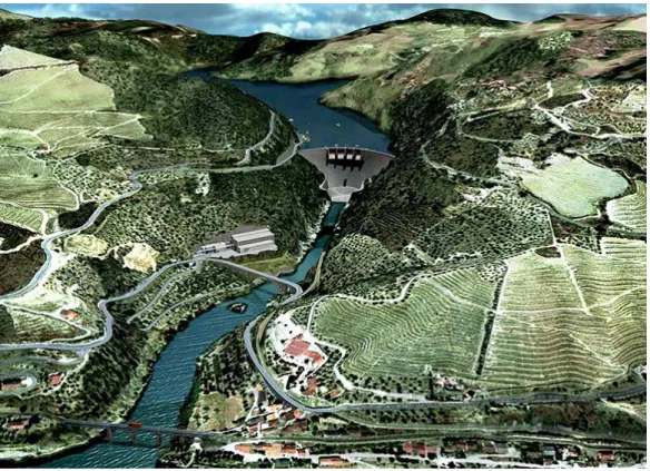
Figure 12 – Artist’s depiction of the Tua valley after the construction of the dam.
Source: COSTA, 2011.
These examples are important venues to think with, especially when facing a pres-sing need to reach between the too often separate worlds of academic analysis and civic engagement. How might we as scholars make our work relevant to multiple publics and offer new ways for people to question their assumptions about the technological world so frequently hidden within the mundane. Rather than being caught up in value judgments about a valley, a railroad, a dam, or a tunnel exclusively – we aim to engage the very
titution of these values themselves, and how they may change with time, audience and economic context. Apart from the interchanging binary between the romanticization and demonization of technological change, we may venture to instead see it as a continuous, contentious, and entangled process of history in the making60.
SOURCES
ALVES, Tiago Rodrigues (2012) – Souto Moura enterra central de Foz Tua em bunker no monte. «Jornal de Notícias», 29/02/2012. Available in <www.jn.pt/local/noticias/braganca/carrazeda-de-ansiaes/interior/ souto-moura-enterra-central-de-foz-tua-em-bunker-no-monte-2332574.html> [Visited on 26/05/2015]. COSTA, António Freitas da (2011) – Novos projectos hidroeléctricos. Barragem de Foz Tua. Cerimónia de lan-
çamento da obra. Apresentação do projecto. Available in <www.a-nossa-energia.edp.pt/arquivo_conteu-dos/resources/presentations/apresentacao_foz_tua.pdf> [Visited on 25/05/2015].
EDP (2016) – Barragem de Foz Tua. Available in <www.a-nossa-energia.edp.pt/centros_produtores/empre- endimento.php?item_id=80> [Visited on 25/05/2015].
GOMES, Paulo Zacarias (2016) – Governo cancela construção de barragens do Alvito e Girabolhos e suspende Fridão. «Negócios», 18/04/2016. Available in <www.jornaldenegocios.pt/empresas/energia/detalhe/ governo_cancela_construcao_de_barragens_do_alvito_e_girabolhos_e_suspende_fridao.html> [Visi-ted on 26/05/2015].
PARAFITA, Alexandre (2016) – Vem aí o monstro… «Jornal de Notícias», 06/05/2016. Available in <www. jn.pt/opiniao/convidados/interior/vem-ai-o-monstro-5160492.html>. [Visited on 26/05/2015]. PINTO, Luísa (2016) – Campanha alerta que estes podem ser os últimos meses do Tua. «Público», 22/05/2016.
Available in <www.publico.pt/local/noticia/campanha-alerta-que-estes-podem-ser-os-ultimos-meses--do-tua-1732684?page=-1> [Visited on 26/05/2015].
RUELA, Rosa; MONTEIRO, Lucília (2016) – A última viagem ao Tua. «Visão», n.º 1212 (26/05/2016), p. 30-40.
BIBLIOGRAPHY
ALEGRIA, Maria Fernanda (1990) – A organização dos transportes em Portugal: as vias e o tráfego (1850-1910). Lisbon: Centro de Estudos Geográficos.
AZEVEDO, Ana Carina; SALGUEIRO, Ângela (2015) – Evolução do sistema de mobilidade e decadência da linha. In PEREIRA, Hugo Silveira, ed. – A linha do Tua (1851-2008). Porto: EDP; MIT Portugal Program; Universidade do Minho, p. 458-472.
BEIRA, Eduardo (2014) – 1887. A linha do Tua e as fotografias de E. Biel. Porto: EDP; MIT Portugal Program; Universidade do Minho.
CALLON, Michel (1986, abridged 1998) – Some Elements of a Sociology of Translation: Domestication of the Scallops and Fisherman of St. Brieuc Bay. In BIAGIOLI, Mario, ed. – The Science Studies Reader. New York, NY; London: Routledge, p. 67-83.
CALLON, Michel; LATOUR, Bruno (1992) – Don’t Throw the Baby Out with the Bath School! A Reply to Collins and Yearly. In PICKERING, Andrew, ed. – Science as Practice and Culture. Chicago, IL: Univer-sity of Chicago Press, p. 343-368.
CAROLINO, Júlia; PINTO-CORREIA, Teresa (2011) – Paisagem material, paisagem simbólica e identidade no concelho de Castelo de Vide. «Análise Social», no. 46:198, p. 89-113.
DARIAN-SMITH, Eve (1999) – Bridging Divides. The Channel Tunnel and English Legal Identity in the New Europe. Berkeley, CA; London: The University of California Press.
DELICADO, Ana; FIGUEIREDO, Elisabete; SILVA, Luís (2016) – Community perceptions of renewable ener-gies in Portugal: Impacts on environment, landscape and local development. «Energy Research & Social Science», no. 13, p. 84-93.
DEVINE-WRIGHT, Patrick; HOWES, Yuko (2010) – Disruption to place attachment and the protection of restorative environments: a wind energy case study. «Journal of Environmental Psychology», no. 30:3, p. 271-280.
EDGERTON, David (2008) – The Shock of the Old. Technology and Global History since 1900. Londres: Profile Books.
ESCOBAR GÓMEZ, Gabriel (1995) – Ordenación del territorio y planificación hidrológica. «Ciudad y Terri-torio. Estudios territoriales», no. 106, p. 825-840.
ESCOBAR GÓMEZ, Gabriel; HERRERA RUEDA, Macarena (1993) – Medio ambiente y ordenación del terri-torio de rango regional. El Suelo No Urbanizable en las Directrices de Ordenación del Territerri-torio del País Vasco. «Ciudad y Territorio. Estudios territoriales», no. 98, p. 525-532.
FÉLIX, Nuno Miguel Cardoso (2010) – Reflexões e Análises Críticas ao Programa Nacional de Barragens de Elevado Potencial Hidroeléctrico. Porto: Faculdade de Engenharia da Universidade do Porto. Masters dissertation.
FERNANDES, António Teixeira (1998) – Os fenómenos políticos: sociologia do poder. Porto: Afrontamento. HUGHES, Thomas Parker (1983) – Networks of Power. Electrification in Western Society, 1880-1930.
Balti-more, MD; London: The Johns Hopkins University Press.
JACKSON, John Brinckerhoff (1984) – Discovering the Vernacular Landscape. Yale, CT: Yale University Press. JASANOFF, Shelia, ed. (2004) – States of Knowledge: The Co-production of Science and the Social Order.
London: Routledge.
____ (2005) – Designs on Nature: Science and Democracy in Europe and the United States. Princeton, NJ; Woodstock: Princeton University Press.
LAGE, Maria Otília Pereira; BEIRA, Eduardo (2013) – Tua. Colectânea Literária: o vale, o rio e a lineal-férrea. Porto: EDP; MIT Portugal Program; Universidade do Minho.
LAGE, Maria Otília Pereira (2015) – A linha na literatura. In PEREIRA, Hugo Silveira, ed. – A linha do Tua (1851-2008). Porto: EDP; MIT Portugal Program; Universidade do Minho, p. 365-381.
LATOUR, Bruno (2004) – Politics of Nature. How to bring the sciences into democracy. Cambridge: Harvard University Press.
MACEDO, Marta Coelho de (2009) – Projectar e construir a Nação. Engenheiros e território em Portugal (1837-1893). Coimbra: Universidade de Coimbra. Ph.D. dissertation.
McCANTS, Anne; BEIRA, Eduardo; CORDEIRO, José Manuel Lopes; LOURENÇO, Paulo B., PEREIRA, Hugo Silveira, eds. (2016) – New Uses for Old Railways. Porto: Iniciativa TUA; IN+; Universidade do Minho; MIT Portugal Program.
MARTINS, Lurdes; VASCONCELOS, Graça; LOURENÇO, Paulo B. (2015) – A construção e os aspectos laborais. In PEREIRA, Hugo Silveira, ed. – A linha do Tua (1851-2008). Porto: EDP; MIT Portugal Program; Universidade do Minho, p. 95-114.
MITCHELL, W. J. T. (2002) – Landscape and Power. Chicago, IL; London: Chicago University Press. MOSCOVICI, Serge (2005) – Representações sociais. Investigações em psicologia social. Petrópolis: Vozes. NYE, David (1999) – Technologies of Landscape. Cambridge, MA; London: The MIT Press.
PEREIRA, Hugo Silveira (2016) – Máquinas e Homens: o material circulante da linha do Tua. Porto: Iniciativa TUA; IN+; Universidade do Minho; MIT Portugal Program.
PICKERING, Andrew (1993) – The Mangle of Practice: Agency and Emergence in the Sociology of Science. In BIAGIOLI, Mario, ed. – The Science Studies Reader. New York, NY; London: Routledge, p. 372-393. RENNIE, Neil (1995) – Far-Fetched Facts: The Literature of Travel and the Idea of the South Seas. Oxford:
Oxford University Press.
ROLLINS, William H. (1995) – Whose Landscape? Technology, Fascism, and Environmentalism on the Natio-nal Socialist Autobahn. «AnNatio-nals of the Association of American Geographers», no. 85: 3, p. 494-520.
SPERO, Ellan Fei (2013) – The Tua River Valley: A “Technological Landscape”. In McCANTS, Anne; BEIRA, Eduardo; CORDEIRO, José Manuel Lopes; LOURENÇO, Paulo B., eds. – Railroads in Historical Context. Porto: EDP; MIT Portugal Program; Universidade do Minho, vol. 3, p. 239-248.
VISEU, Albano (2007) – Memórias históricas de um espaço rural: três aldeias de Trás-os-Montes (Coleja, Cachão e Romeu), ao tempo do Estado Novo. Porto: Faculdade de Letras da Universidade do Porto. Ph.D. dissertation.
VIEIRA, António; PIMENTA, Eduarda; LOURENÇO, António; LOUREIRO, Eurico (2013a) – Changes in land use in the Tua valley during the 20th century: a GIS-based approach. In McCANTS, Anne; BEIRA, Eduardo; CORDEIRO, José Manuel Lopes; LOURENÇO, Paulo B., eds. – Railroads in Historical Context. Porto: EDP; MIT Portugal Program; Universidade do Minho, vol. 3, p. 107-124.
____ (2013b) – Terraces in the Tua valley. In McCANTS, Anne; BEIRA, Eduardo; CORDEIRO, José Manuel Lopes; LOURENÇO, Paulo B., eds. – Railroads in Historical Context. Porto: EDP; MIT Portugal Program; Universidade do Minho, vol. 3, p. 125-142.
VOGELER, Ingolf (1996) – State Hegemony in Transforming the Rural Landscapes of Eastern Germany: 1945-1994. «Annals of the Association of American Geographers», no. 86:3, p. 432-458.
VLEUTEN, Erik van der (2006) – Understanding Network Societies. Two Decades of Large Technical System Studies. In VLEUTEN, Erik van der; KAIJSER, Arne, eds. – Networking Europe. Transnational Infras-tructures and the Shaping of Europe, 1850-2000. Sagamore Beach, MA: Science History Publications, p. 279-314.